Showing 10387 items
matching plan
-
 Glen Eira Historical Society
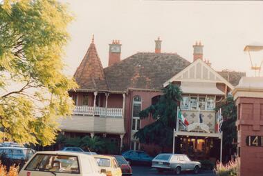
Plan - Tudor Court, Kooyong Road, 141, Caulfield North
Six page colour pamphlet of Tudor Court with interior and exterior photographs. Includes menu for functions, pamphlet describing mid week wedding specials with photos of interior, photocopy of part of Ground Floor floor plans, circa 1985, and colour photograph. All undated except floor plan in 1983.caulfield, kooyong road, tudor court, mansions, weddings, reception rooms, orlane institut de beaute, menus, architectural features, federation style, towers, chimneys, floor plans -
 Bendigo Historical Society Inc.
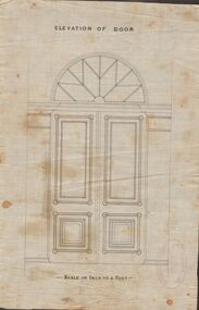
Document - MARKS COLLECTION: DRAWING FOR ELEVATION OF DOOR
Drawn on waxed paper. On top of plan 'Elevation of Door' printed in black ink, on bottom 'Scale an inch to a foot'. Plan shows double doors, arched window above. Contained in items from Fortuna Villa, although not marked as such. On bottom of plan purple ink stamp 'Vahland & Getzschmann, Architects, Sandhurst'.Vahland & Getzschmann, Architects, Sandhurst.bendigo, house, fortuna villa -
 Glen Eira Historical Society
Plan - Kooyong Road, 18, Caulfield North
Copies of correspondence, (5 pages) dated 8/07/1954 from valuer to Mr K W Blue concerning valuation of property at 18 Kooyong Road, Caulfield North. Correspondence provides property measurements, details of property, improvements and costings. In addition, the file also includes 2 pages of handwritten notes, undated and unattributed providing valuation details. Also included in the file is a hand-drawn property plan (150mm x 155mm) undated and unattributed. The plan may be of the property at 18 Kooyong Road ; the room measurements given by the plan correspond with the measurements for 18 Kooyong Road given by the correspondence. However, the plan has been labeled (in a biro pen) as 15 Kooyong Road, East St Kilda, though 18 has been written above the number 15.blue k w, a’beckett mrs, kooyong road, malonga court, caulfield, east st kilda, brick houses, land values, caulfield north -
 Federation University Historical Collection
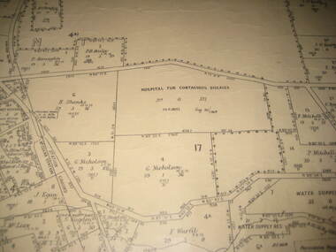
Plan - Plan - Cadastral, Parish of Ballaarat - Sheet 3 (only), 03/03/1932
Sheet 3 of the Parish of Ballart showing Government roads, crown allotments, dimensions, crown grantees, date of grants, etc,ballarat, plan, hospital for contagious diseases, sebastopol, sebastopol rifle range, fiscalini, leigh river, yarrowee creek -
 Williamstown Botanic Gardens- Hobsons Bay City Council
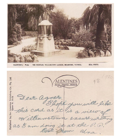
Postcard - Williamstown Botanic Gardens, c1900-1920
The original postcards in this series (2013.002 to 2013.018) were generously loaned to Williamstown Botanic Gardens by a private collector for copying. The fountain is located on the southern side of the ornamental lake and was erected to celebrate the jubilee of the municipality (17 March 1906). Controversy surrounded the commission for the design and construction of the fountain, as it was originally assigned to a contractor in Carlton. Williamstown residents insisted the fountain be designed and constructed locally, and on December 1906 the fountain was tendered by local firm Bliss and Sons and opened for public use in 1906. The fountain features a symmetrical plan, consisting of fur granite columns supporting a granite canopy and is fully operational following restoration work in 2013. The idea for the fountain came from an elderly resident of Williamstown who suggested the council follow the example of Ballarat’s gardens with its many statues and monuments. The postcards are evidence of the interest the gardens held as a subject for postcard publishers. The text and images provide a snapshot into fashions, social interests and concerns of the time. The professionally produced images provide a pictorial history of Gardens including changing planting styles, various structures and features of the Gardens eg the aviary, cannons, the fountain, the second Curator’s Lodge and gates. The images offer an opportunity to compare garden vistas with the present day. The significance of the fountain is its reflection of how Williamstown people felt for their Gardens and the importance placed on investing in locally operated business. It was noted in the Brief Jottings column of the Williamstown Chronicle, February 24 1906, the fountain is a “We favor the erection of the jubilee fountain in the Giffard-street (Williamstown Botanic) Gardens. Ornaments of that kind there will make that beauty spot even more attractive.” Sepia scene of a fountain situated on paths bordered with rocks. The fountain in on a plinth and the postcard shows the plaque and two of the four drinking stations. The fountain features a symmetrical plan, consisting of four granite columns supporting a granite canopy. Front: VALENTINE’S, M.355 THE FOUNTAIN, WILLIAMSTOWN GARDENS MELBOURNE, VICTORIA. REAL PHOTO. Reverse: vertical on left side of card and underlined: ‘Published by the Valentine & Sons Publishing Co. Ltd. / Queen St, Melb’. Top centre of card: Contains logo of ‘VALENTINES / REAL PHOTO SERIES’. The postcard is addressed to ‘Dear Agnes’ from ‘Una’. Marked in pencil on to right hand corner ‘1920 / $8’ believed to be put on the postcard by the vendor. postcard, gardens, post-card, williamstown-botanic-gardens, hobsons-bay-city-council, jubilee-fountain, fountain drinking-fountain, 1920, granite, bliss-and-sons, 1906 -
 City of Moorabbin Historical Society (Operating the Box Cottage Museum)
A laminated , photocopy of the ‘Plan of Box Cottage c 1865 ‘, 1985
The original small, pioneer cottage was built in the late 1840s to early1850s, by an unknown pioneer. It was located on part of a 30 Acre allotment that was originally part of Dendy’s Special Survey granted in 1841. The doors and window sashes, (made of red deal joinery timber), as well as the brass locks and fittings, are from the original cottage, and were imported from England. The fire-place bricks are from the original cottage, and are sun-dried, (not kiln fired), and are hand-made. Convict marks can be seen on two bricks. There is a small display of external cladding shingles from the original pioneer cottage. These shingles were hand-split, and most likely made from locally collected timber The nails included in this display were used to fasten the shingles on the original cottage, and are also hand-made. The cottage was occupied by William Box and family from 1865 until 1914 when it was sold to William Reitman who resided there until 1950. The enamel nameplate, “Colonial”, on the wall of the cottage, was the name chosen for the original pioneer cottage by Mr William Reitman, when he purchased the property in around 1915, for 1200 Pounds approximately. In 1974 Mr Lewis, a timber specialist, found the dilapidated building on property he had recently purchased in Jasper Rd and suggested it be reconstructed and relocated. Moorabbin Council agreed and the cottage was rebuilt just about 250 metres from its original site. The cost of the rebuild was met by 'Victoria's 150th Committee, plus a small grant from the City of Moorabbin, and Mr Laurie Lewis donated much of the timber for the reconstruction. The re-constructed cottage plan has followed faithfully the original dimensions, and plan of the original pioneer cottage, and as many original items from that cottage’s long occupation have been incorporated. The photographs in Album 1 record the progress of the reconstruction from February 1984 to the First Public Open Day November 18th 1984Mrs H Deam and Mr A. Smith, CMHS members, photographed the progress of the 'Reconstruction' from February 1984 to November 1984. Although 'Box Cottage' is a re-construction, it is an unique museum that, being located in the midst of a modern community in Ormond Victoria, can educate and demonstrate many aspects of the early settler’s way of life in Victoria. As such, it is an invaluable resource for students and all kinds of visitors. A laminated , photocopy of the ‘Plan of Box Cottage c 1865 ‘ Hand drawn layout of 2 houses with shrubs, trees, plants, wells, gardens on the Box Cottage site c1930 as recalled by Stefanie Rietman Rennick. brighton, moorabbin, cottages, pioneers, ormond, colonial, mckinnon, dendy henry, box william, box elizabeth, reitman william, convicts lewis timber co. ltd., deam h, museums, box alonzo, smith a, -
Bendigo Historical Society Inc.
Map - SPRING PLAINS, Examined 31/01/1876
Map: Parish of Springplains, County of Dalhousie. Parish plan June 1874 A.D. Scott Examined E.D. 4.7.74 Additions made March 1877 Written in blue " See new plan."map, dalhousie, parish plan, spring plains -
Lakes Entrance Regional Historical Society (operating as Lakes Entrance History Centre & Museum)
Book, Perrott Lyon Mathieson Pty. Ltd, Journal of Australasian Mining History Vol. 8 - Mining for Oil in Victoria. The Lakes Entrance Shaft, 1991
A commissioned study of the Lake Tyers Beach and surrounding area prior to future planning with regard to urban development, tourism and conservation of natural beauty. Contains illustrations and a plan of proposed boat ramps.waterfront, township, tourism -
Whitehorse Historical Society Inc.
Pamphlet, Halliday Park, c1988
A pamphlet describing Halliday Park in Mitcham outlining its history and plans for its development as a city park. Members of the Committee of Management are listed and the verso has the concept plan being developed.A pamphlet describing Halliday Park in Mitcham outlining its history and plans for its development as a city park. Members of the Committee of Management are listed and the verso has the concept plan being developed.A pamphlet describing Halliday Park in Mitcham outlining its history and plans for its development as a city park. Members of the Committee of Management are listed and the verso has the concept plan being developed.halliday park, city park -
Whitehorse Historical Society Inc.
Audio - Audio Cassette, Municipal Planning, 13/04/1996 12:00:00 AM
Cassette - Talk by Ron O'Neill on Municipal Planning given to Nunawading & District Historical Society meeting, 13th April, 1996. Ron was the former Strategic Planning Officer in the former City of Nunawading.nunawading and district historical society, o'neill, ron, municipal planning -
Bendigo Historical Society Inc.
Document - MARKS COLLECTION: PLAN OF CHIMNEY STACK
Unlabelled plan, drawing shows side view of chimney stack, '5 feet' written on base of chimney. Plan could be associated with a mine on New Chum Reef Line, Victoria Hill.bendigo, mining, chimney side section, chimney stack -
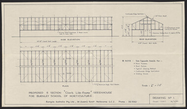 University of Melbourne, Burnley Campus Archives
Plan, "Clark Lite-Frame" Greenhouse, 1965
Plans for new greenhouse by Banyule Australia Pty. Ltd. (1) Drawing No 1 G.W.C. Proposed 8 Section "Clark Lite-Frame" Greenhouse for Burnley School of Horticulture, Plan Side Elevation, End Elevation. (2) Drawing No 2 Typical Glazing Detail, End Corner Detail, Typical Section Thru' Greenhouse. (3) Drawing No 3. Continuous Ridge Ventilator detail. Drawing No. 4. Sliding Door Arrangement. Drawing No 5. Framing Arrangement. Dated 24.10.1965 - 29.10.1965.banyule, greenhouse -
 University of Melbourne, Burnley Campus Archives
Plan, Perennial Border Spring Display, 1982-1997
(1) Tracing paper plan of bed. (2) Perennial Border Spring Display Planted 1982, plantings numbered but no names. (3) Pencil on paper, names of plants, some in pen. Area now known as the Grey Garden. Old Storage Shed cleared in 1979. (4) Tracing paper copy, VCAH Burnley Plan Survey: Perennial Border and Environs, dated 8.11.90. Scale 1:100. This might be where the Herbaceous Border is in 2012. (Also see 11.0615).gardens, shed, vcah -
 Bendigo Historical Society Inc.
Book - LESSON PLANS AND WORK PROGRAM, 27/7/1954 - 18/11/1955
Book, Lesson plans and work program books.The lesson plans book is a large book bound by two screws through front and back heavy cardboard which is covered in black material.The plans range from 20/7/1954 to 18/11/1955.They cover a lot of local schools in the Bendigo area.book, bendigo, education -
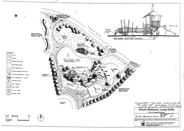 Bendigo Historical Society Inc.
Document - LONG GULLY HISTORY GROUP COLLECTION: CHUM RESERVE LONG GULLY
Copy of a plan of the Chum Reserve, Long Gully, dated September 1998. The plan between Derwent Drive and Dyason Court show play area, trees, swings, fire pit, tree house and grassy area. There is also a plan of the tree house - South East Elevation. Drawn by Mary Jeavons Landscape Architects.bendigo, history, long gully history group, the long gully history group - chum reserve long gully, shared action long gully community house, city of greater bendigo, mary jeavons landscape architects -
Port Melbourne Historical & Preservation Society
Plan - Proposed Alterations, Port Melbourne Town Hall, B S Elms & Co Pty Ltd, 23 Jun 1966
Drawing from a set of two, 1966 - Plans - details of alterations to Town Hall - not proceeded with. Details of Council Chamber, Councillors Room and first floor of Town Hall, hand coloured and material samples attachedport melbourne town hall -
Port Melbourne Historical & Preservation Society
Plan - Liardet Community Centre, Port Melbourne, Barry Merat, Architect, 1988 - 1989
Set of 3 preliminary drawings, plan for remodelling former Temperance Hall as new "Liardet Community Centre" (in use at this time as Senior Citizens' Centre and Children's Library) - copied from sketches then coloured. 1988.built environment - civic, port melbourne temperance hall, barry merat, liardet community centre -
Port Melbourne Historical & Preservation Society
Plan - Annotated and handcoloured by Peter Libbis to indicate his research into Libbis family residences and hotels on copy of a section of an MMBW map, Melbourne and Metropolitan Board of Works, c. 1980s
Peter LIBBIS obtained these copies from the MMBW when he researched his family history in the 1980s. He has annotated them, colour in hotels etc. Donated to Society in 1997.One of a group of 19 photocopies of various 20th century MMBW plans, annotated/coloured in to indicate residences of Libbis family and local hotels, by Peter LIBBIS in family and hotel research - Harper's and lagoon, 1950s?business and traders - hotels, built environment - domestic, transport - railways, melbourne and metropolitan board of works, libbis family -
Port Melbourne Historical & Preservation Society
Plan - Annotated and handcoloured by Peter Libbis to indicate his research into Libbis family residences and hotels on copy of a section of an MMBW map, Melbourne and Metropolitan Board of Works, c. 1980s
Peter LIBBIS obtained these copies from the MMBW when he researched his family history in the 1980s. He has annotated them, colour in hotels etc. Donated to Society in 1997.One of a group of 19 photocopies of various 20th century MMBW plans, annotated/coloured in to indicate residences of Libbis family and local hotels, by Peter LIBBIS in family and hotel research - Princes, Graham to LiardetAnnotation: referenced on back to our valuation books (302)business and traders - hotels, built environment - domestic, transport - railways, melbourne and metropolitan board of works, libbis family, thomas libbis -
Southern Sherbrooke Historical Society Inc.
Plan - Plans for Proposed Sports Pavillion and Scout Hall at Menzies Creek
Two copies of sketches for a proposed sports pavilion and Scout Hall at Menzies Creek, from multiple angles (front, side and rear). All sketches are at 1:100 scale. Includes floor plan of the building. -
 University of Melbourne, Burnley Campus Archives
Plan, Department of Public Works, Burnley School of Horticulture, c.1951
Department of Public Works, Melbourne, Victoria plan No. 51/66 of extension of grounds. Area bounded by Yarra River to north and south. Additional areas coloured. Position of new buildings and new house shown.burnley school of horticulture -
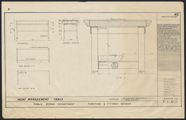 University of Melbourne, Burnley Campus Archives
Plan, Home Management Table, 1959
Plan. Specification No. 45 for Home Management Table for Education Dept., High Schools. Drawing No. T:1:11:1 for Public Works Dept., Furniture & Fittings Branch, Chief Architect. Drawn by K.H.furniture -
University of Melbourne, Burnley Campus Archives
Plan - Photocopy, County, c.1930
Given to Archives by Emma Ferguson and Jo van Berkel who used it in preparation of their 1994 thesis on the history of the Burnley Gardens. Photocopy of a plan depicting Burnley College as it was in the 1930's. It shows the Pavilion and surrounding gardens, coops and yards, various small outbuildings. Shows the contours of the land in the northern section of the property bordering Swan St. Some additions and comments have been added to original document, mainly to do with sewerage and water supplyburnley college, pavilion, emma ferguson, jo van berkel -
University of Melbourne, Burnley Campus Archives
Plan - Photocopy, Burnley College, 1980
Copied by Emma Ferguson and Jo van Berkel for their Oct 1994 ThesisPhotocopy of plan of Burnley College naming the majority of buildings, including Administration Building, residence, silo bins, store, manure bins, milking shed, P lant Research Lab., breeder pens, Gardensburnley college, pavilion, emma ferguson, jo van berkel -
University of Melbourne, Burnley Campus Archives
Plan, Richmond Park, 1926-1954
Photocopy of Section of a Survey Plan 1926 showing fencing and hedging dated 1927. Stamp, Department of Lands and Survey 8.9.54 Neg 18378 See F? 71331(4?). From the Dept of Lands and Survey.Part of handwritten notes signed "Mr Anderson ? 28/2/45."parks, richmond -
University of Melbourne, Burnley Campus Archives
Plan, SAB Surv(ey?), c. 1986
Copy with right side cut off so difficult to read. Plan of Student Amenity Building and surrounding area with legend. By Peter Ell(emans? Student in 1986) Subject: Engineering. Scale 1:100.students, amenities, burnley college of horticulture, student amenity building -
 University of Melbourne, Burnley Campus Archives
Plan, Approved Signs for Burnley Gardens, 1996
(1) 2 copies, list of signs with descriptions. (2) Tracing paper copy, Suggested Construction for Interpretative Signs Student Gardens V.C.A.H. Burnley. (3) Plan of Campus with placement of signs as per (1).students, gardens, vcah, signage, burnley gardens -
Glen Eira Historical Society
Plan - St James Parade, 12, Elsternwick
Hand drawn pencil plan of 12 St. James Parade, Elsternwick, unknown author and undated.st. james parade, elsternwick, plans -
Port Melbourne Historical & Preservation Society
Document - Report, Ewan Ogilvy's Bayside Papers, Bayside EES Inquiry, Ewan Ogilvy's Bayside Papers, Box One, 1988
Ewan Ogilvy, former Melbourne Councillor and also of Community Services Victoria, Inner Urban Ministerial Advisory Committee and Uniting Church's Centre for Urban Research and Action (CURA), was instrumental in social justice approaches to town planning. He and CURA's Social Justice and the City Project funded Port Melbourne community groups protesting against the SCDC development in 1987. His files were presented to the Society in May 2001 on his preparation for leaving Victoria.From Ewan Ogilvy's chronologically organised 'Bayside Papers' relating to the proposed development of Port Melbourne industrial land in the late 1980s: EES Inquiry report to the Minister for Planning and Environment 7 April 1988, included in bound black file. Appendix 5: Panel's recommendation re site contamination (one page)All items signed 'Ewan Ogilvy'town planning, town planning - proposals shelved - bayside, public action campaigns, environmental issues, ewan ogilvy, centre for urban research and action, sandridge city development co pty ltd, scdc, linton r lethlean, judy arndt, francis b barnes -
Port Melbourne Historical & Preservation Society
Document - Report, Ewan Ogilvy's Bayside Papers, Bayside EES Inquiry, Ewan Ogilvy's Bayside Papers, Box One, 1988
Ewan Ogilvy, former Melbourne Councillor and also of Community Services Victoria, Inner Urban Ministerial Advisory Committee and Uniting Church's Centre for Urban Research and Action (CURA), was instrumental in social justice approaches to town planning. He and CURA's Social Justice and the City Project funded Port Melbourne community groups protesting against the SCDC development in 1987. His files were presented to the Society in May 2001 on his preparation for leaving Victoria.From Ewan Ogilvy's chronologically organised 'Bayside Papers' relating to the proposed development of Port Melbourne industrial land in the late 1980s: EES Inquiry report to the Minister for Planning and Environment 7 April 1988, included in bound black file. Appendix 6: Panel's response to PMCC Counsel Michael Wright 6ppAll items signed 'Ewan Ogilvy'town planning, town planning - proposals shelved - bayside, public action campaigns, environmental issues, ewan ogilvy, centre for urban research and action, sandridge city development co pty ltd, scdc, linton r lethlean, judy arndt, francis b barnes, michael wright - qc, port melbourne city council