Showing 5071 items
matching victoria st.
-
 St Kilda Historical Society
Photograph - Photo map, 13/01/1968
One of a series of photo-maps produced for the Department of Crown Lands and Survey (1857-1983). For correlation with a current map, and access to other historical photo maps of Victoria, see the Historic Photo-Maps Index published by the Department of Environment, Land, Water and Planning at https://services.land.vic.gov.au/DELWPmaps/historical-photomaps/Black and white aerial photograph2138 State Aerial Survey Melbourne 1968 Proj. Run 26 13.1.68 5100 ASL 203st kilda west, albert park, fawkner park, south yarra, prahran, windsor, 1968 -
 St Kilda Historical Society
Photograph - Photo map, 11/01/1968
One of a series of photo-maps produced for the Department of Crown Lands and Survey (1857-1983). For correlation with a current map, and access to other historical photo maps of Victoria, see the Historic Photo-Maps Index published by the Department of Environment, Land, Water and Planning at https://services.land.vic.gov.au/DELWPmaps/historical-photomaps/Black and white aerial photographVic 2132 State Aerial Survey Melbourne 1968 Proj. Run 27E 11.1.68 5100 ASL 69st kilda, albert park, st kilda east, st kilda beach, alma park, windsor, prahran, 1968 -
 St Kilda Historical Society
Photograph - Photo map, 11/01/1968
One of a series of photo-maps produced for the Department of Crown Lands and Survey (1857-1983). For correlation with a current map, and access to other historical photo maps of Victoria, see the Historic Photo-Maps Index published by the Department of Environment, Land, Water and Planning at https://services.land.vic.gov.au/DELWPmaps/historical-photomaps/Black and white aerial photographVic 2132 State Aerial Survey Melbourne 1968 Proj. Run 28E 11.1.68 5100 ASL 81st kilda, balaclava, st kilda east, ripponlea, elwood, elsternwick, caulfield, st kilda botanical gardens, 1968 -
 St Kilda Historical Society
Photograph - Photo map, 11/01/1968
One of a series of photo-maps produced for the Department of Crown Lands and Survey (1857-1983). For correlation with a current map, and access to other historical photo maps of Victoria, see the Historic Photo-Maps Index published by the Department of Environment, Land, Water and Planning at https://services.land.vic.gov.au/DELWPmaps/historical-photomaps/Black and white aerial photographVic 2132 State Aerial Survey Melbourne 1968 Proj. Run 29E 11.1.68 5100 ASL 194elwood, elwood beach, elwood park, elsternwick park, ripponlea, elwood canal, balaclava, st kilda, 1968 -
 St Kilda Historical Society
Photograph - Photo map, 11/01/1968
One of a series of photo-maps produced for the Department of Crown Lands and Survey (1857-1983). For correlation with a current map, and access to other historical photo maps of Victoria, see the Historic Photo-Maps Index published by the Department of Environment, Land, Water and Planning at https://services.land.vic.gov.au/DELWPmaps/historical-photomaps/Black and white aerial photographVic 2132 State Aerial Survey Melbourne 1968 Proj. Run 27E 11.1.68 5100 ASLst kilda, st kilda west, st kilda pier, catani gardens, st kilda beach, albert park, 1968 -
 St Kilda Historical Society
Photograph - Photo map, 11/01/1968
One of a series of photo-maps produced for the Department of Crown Lands and Survey (1857-1983). For correlation with a current map, and access to other historical photo maps of Victoria, see the Historic Photo-Maps Index published by the Department of Environment, Land, Water and Planning at https://services.land.vic.gov.au/DELWPmaps/historical-photomaps/Black and white aerial photographVic 2132 State Aerial Survey Melbourne 1968 Proj. Run 29E 11.1.68 5100 ASL 196elwood, elwood park, elwood canal, elwood beach, st kilda marina, mc moran reserve, point ormond, 1968 -
 St Kilda Historical Society
Photograph - Photo map, Department of Crown Lands and Survey (1857-1983), 22/01/1970
One of a series of photo-maps produced for the Department of Crown Lands and Survey (1857-1983). For correlation with a current map, and access to other historical photo maps of Victoria, see the Historic Photo-Maps Index published by the Department of Environment, Land, Water and Planning at https://services.land.vic.gov.au/DELWPmaps/historical-photomaps/Black and white aerial photographVic 2358 Department of Crown Lands and Survey Victoria,.© Melbourne 1970 Project Run 41E 22.1.70 5,100 ASL 62caulfield, caulfield north, st kilda east, armadale, 1970 -
 St Kilda Historical Society
Photograph - Photo map, 14/12/1963
One of a series of photo-maps produced for the Department of Crown Lands and Survey (1857-1983). For correlation with a current map, and access to other historical photo maps of Victoria, see the Historic Photo-Maps Index published by the Department of Environment, Land, Water and Planning at https://services.land.vic.gov.au/DELWPmaps/historical-photomaps/Black and white aerial photographVic 1807 Melbourne 1963 Project Run 17 14.12.63 Lens 205 152.70 M/M 5.150 36st kilda, st kilda botanical gardens, balaclava, st kilda east, elwood canal, ripponlea, caulfield north, elwood, caulfield, 1963 -
 St Kilda Historical Society
Photograph - Photo map, Department of Crown Lands and Survey (1857-1983), 22/01/1970
One of a series of photo-maps produced for the Department of Crown Lands and Survey (1857-1983). For correlation with a current map, and access to other historical photo maps of Victoria, see the Historic Photo-Maps Index published by the Department of Environment, Land, Water and Planning at https://services.land.vic.gov.au/DELWPmaps/historical-photomaps/Black and white aerial photographVic 2358 Department of Crown Lands and Survey Victoria,.© Melbourne 1970 Project Run 42E 22.1.70 5,100 ASL 77st kilda, st kilda east, st kilda marina, elwood, elwood canal, elsternwick park, point ormond, balaclava, mc moran reserve, ripponlea, st kilda botanical gardens, peanut farm, 1970 -
 St Kilda Historical Society
Photograph - Photo map, Department of Crown Lands and Survey, 22/01/1970
One of a series of photo-maps produced for the Department of Crown Lands and Survey (1857-1983). For correlation with a current map, and access to other historical photo maps of Victoria, see the Historic Photo-Maps Index published by the Department of Environment, Land, Water and Planning at https://services.land.vic.gov.au/DELWPmaps/historical-photomaps/Black and white aerial photographVic 2358 Department of Crown Lands and Survey Victoria,.© Melbourne 1970 Project Run 43E 22.1.70 5,100 ASL 208elwood, elwood beach, point ormond, elwood park, elwood canal, mc moran reserve, 1970 -
 St Kilda Historical Society
Photograph - Photo map, Department of Crown Lands and Survey, 22/01/1970
One of a series of photo-maps produced for the Department of Crown Lands and Survey (1857-1983). For correlation with a current map, and access to other historical photo maps of Victoria, see the Historic Photo-Maps Index published by the Department of Environment, Land, Water and Planning at https://services.land.vic.gov.au/DELWPmaps/historical-photomaps/Black and white aerial photographCONTROLLED Vic 2358 Department of Crown Lands and Survey Victoria,.© Melbourne 1970 Project Run 41E 22.1.70 5,100 ASL 66st kilda, albert park, st kilda west, catani gardens, st kilda botanical gardens, st kilda pier, st kilda beach, 1970 -
 St Kilda Historical Society
Photograph - Photo map, Department of Crown Lands and Survey, 22/01/1970
One of a series of photo-maps produced for the Department of Crown Lands and Survey (1857-1983). For correlation with a current map, and access to other historical photo maps of Victoria, see the Historic Photo-Maps Index published by the Department of Environment, Land, Water and Planning at https://services.land.vic.gov.au/DELWPmaps/historical-photomaps/Black and white aerial photographVic 2358 Department of Crown Lands and Survey Victoria,.© Melbourne 1970 Project Run 42E 22.1.70 5,100 ASL 75st kilda, st kilda beach, st kilda marina, point ormond, st kilda pier, 1970 -
 St Kilda Historical Society
Photograph - Photo map, 14/12/1963
One of a series of photo-maps produced for the Department of Crown Lands and Survey (1857-1983). For correlation with a current map, and access to other historical photo maps of Victoria, see the Historic Photo-Maps Index published by the Department of Environment, Land, Water and Planning at https://services.land.vic.gov.au/DELWPmaps/historical-photomaps/Black and white aerial photographVic 1807 Melbourne 1963 Project Run 16 14.12.1963 Lens 205 152.70 M/M 5.150 177st kilda, st kilda pier, catani gardens, middle park, albert park, st kilda west, st kilda beach, 1963 -
 St Kilda Historical Society
Photograph - Photo map, Department of Crown Lands and Survey, 22/01/1970
One of a series of photo-maps produced for the Department of Crown Lands and Survey (1857-1983). For correlation with a current map, and access to other historical photo maps of Victoria, see the Historic Photo-Maps Index published by the Department of Environment, Land, Water and Planning at https://services.land.vic.gov.au/DELWPmaps/historical-photomaps/Black and white aerial photographVic 2358 Department of Crown Lands and Survey Victoria,.© Melbourne 1970 Project Run 41E 22.1.70 5,100 ASL 64st kilda, st kilda cemetery, balaclava, st kilda east, windsor, caulfield north, alma park, 1970 -
 St Kilda Historical Society
Photograph - Photo map, Department of Crown Lands and Survey, 08/01/1970
One of a series of photo-maps produced for the Department of Crown Lands and Survey (1857-1983). For correlation with a current map, and access to other historical photo maps of Victoria, see the Historic Photo-Maps Index published by the Department of Environment, Land, Water and Planning at https://services.land.vic.gov.au/DELWPmaps/historical-photomaps/Black and white arial photographVic 2345 Department of Crown Lands and Survey Victoria,.© Melbourne 1970 Project Run 40 8.1.70 5,100 ASL 77albert park, fawkner park, south yarra, middle park, prahran, windsor, st kilda, st kilda west, 1970 -
 St Kilda Historical Society
Photograph - Photo map, 22/01/1970
One of a series of photo-maps produced for the Department of Crown Lands and Survey (1857-1983). For correlation with a current map, and access to other historical photo maps of Victoria, see the Historic Photo-Maps Index published by the Department of Environment, Land, Water and Planning at https://services.land.vic.gov.au/DELWPmaps/historical-photomaps/Black and white aerial photographVic 2358 Department of Crown Lands and Survey Victoria,.© Melbourne 1970 Project Run 43E 22.1.70 5,100 ASL 206elwood, elsternwick, elsternwick park, 1970 -
 St Kilda Historical Society
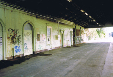
Photograph, St Kilda Railway Station - images collection
Opened in 1857, St Kilda Railway Station is the oldest surviving railway station in Victoria. In the 1920s it was the second busiest station in Victoria after Flinders Street. Competition from motor traffic led to the decline of the station and of St Kilda itself. Services on the line were reduced in 1981 and it was converted to a tram route in November 1987. In 1989, several fires damaged the timber station building and by December, the roof had been destroyed. Metropol Apartments at 60 & 64 Fitzroy Street, completed by 2002, were constructed on the station forecourt site. The former station has been heavily redeveloped and now houses bars, restaurants and retail outlets. Colour photographst kilda, st kilda railway station, st kilda train, fitzroy street -
 St Kilda Historical Society
Photograph, Thalassa Mansion exterior - images collection
Images prior to restoration c2000Images of building at 14/17 Byrne Avenue, Elwood, Victoria before renovation c2000.mansions, byrne avenue, elwood -
 St Kilda Historical Society
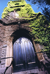
Photograph
... 167 Fitzroy Street, St Kilda, Victoria ... St Kilda, was one of the first Wesleyan churches in Victoria ...The bluestone 1857-58 former Wesleyan Church, on the corner of Fitzroy Street and Princes Street St Kilda, was one of the first Wesleyan churches in Victoria designed in the gothic style. It had a square central entrance tower and early English stepped buttresses and pinnacles above. It was later the St Kilda Uniting Church and was closed on 25 June 1978. It has now been covered to flats.According to Heritage Victoria: The old St Kilda Methodist Church is a finely designed 1850's church building and centrepiece of a group of individually significant buildings in an urban conservation area. Towered churches from the 1850s are rare in Melbourne and this building is thus of special significance in this regard as well as for its design and detailing. This building is an important work of architects Crouch & Wilson. Thomas Crouch was prominent in St Kilda Methodist church affairs and lived locally. He served a term as mayor of St Kilda and also designed the chapel at Pentridge and Methodist churches at Fitzroy, Collingwood, Flemington, Daylesford and Maldon. St Kilda was the home of many of the better off Melbournians in the 1850s, '60s and '70s. The adjacent former Sunday School is one of Melbourne's finest and the combination of fine church and hall side by side gives each added significance. https://vhd.heritagecouncil.vic.gov.au/places/1110churches, fitzroy street, st kilda, crouch, st kilda uniting church, st kilda wesleyan methodist church, princes street -
 St Kilda Historical Society
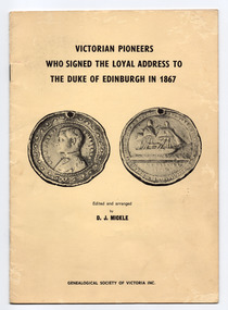
Pamphlet, Genealogical Society of Victoria Inc, Victorian pioneers who signed the loyal address to the Duke of Edinburgh in 1867, 1970
Contents include: Preface, Introductory Note, Port Phillip Pioneers Group, The Address, The Duke's Reply, The Signatories and Dates of Arrival in the ColonyPamphlet of 20 cream coloured pages, printed in black, in yellow coloured cover that is also printed in black. Stapled.non-fictionContents include: Preface, Introductory Note, Port Phillip Pioneers Group, The Address, The Duke's Reply, The Signatories and Dates of Arrival in the Colonyvictoria - history, royal visits, victorian pioneers, prince alfred - duke of edinburgh, 19th century -
 St Kilda Historical Society
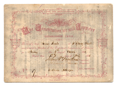
Card - Membership card, Protestant Association of Victoria, The Constitution We Will Support, 1858
The Protestant Association of Victoria was established in 1858. It is distinct from the Victorian Protestant Association that was established in 1917 and was active during and after World War I.The card carries the signatures of the founding members of the Association, including John Pascoe Fawkner, who, after settling in Hobson's Bay in October 1835, amassed large land holdings, was a newspaper proprietor and served on the Legislative Council for 18 years. Cream coloured card certifying the membership of James Hinds of 61 Spring Street as Member no. 17 of the Protestant Association of Victoria on 5 March 1958. Printed in dark brown/purple. Handwriting in black ink. Rules printed on the back.James Hinds of 61 Spring Street was elected as Member of the Protestant Association of Victoria on Friday the 5th of March 1958. Dated this 12th day of July 1958. Signatures of John P Fawkner (President), William Hinds (Treasurer), William Robinson (Secretary). No. 17.1858, john pascoe fawkner, 19th century, protestant association of victoria, victoria - history -
 St Kilda Historical Society
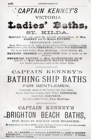
Poster - Advertisement, Captain Kenney's Victoria, 1880s
Captain William Kenney pioneered swimming baths at St Kilda after arriving in Victoria in 1852. Later, he built baths at Brighton Beach.Laminated photocopy of printed advertisement for Kenny's Baths at St Kilda and Brightoncaptain kenney, st kilda bathing ship, brighton beach baths, 19th century -
 St Kilda Historical Society
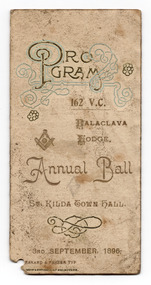
Ephemera - Dance card, Program 162 VC Balaclava Lodge Annual Ball, 1896
Freemason Lodges in Victoria were numbered in the order they were founded. The Balaclava Lodge was 162 and is now defunct. Dance cards became popular in the Victoria era. They were often worn looped around the woman's wrist and had a pencil attached (note the small hole for this at the bottom corner of this card).Folded card printed in gold and blue, being dance card for the Annual Ball of Masonic Lodge 162, Balaclava Lodge, held in St Kilda Town hall on 3 September 1896. List of officers of the lodge printed on the back of card. Inside the card is a list of dances and, in handwriting, the names of dance partners.Names of dance partners, written in pencil. On the back of the card are notes, apparently written much later when the card was donated to the SKHS: 'Gran', 'Mrs Tierney', (illegible).freemasons, dance card, balaclava lodge, st kilda town hall, 19th century -
 St Kilda Historical Society
Ephemera - Dance card, Metropolitan Fire Brigade (Permanent Staff) Third Annual Ball
Dance cards became popular in the Victoria era. They were often worn looped around the wrist and had a pencil attached. This card was worn by a man, as indicated by the female names written against the dances.Green coloured retangular shaped card, edged in gold, printed in black, with corner hole punched. Dance programme on the back. Names inserted in pencil.Names inserted in handwritten pencil. dance card, metropolitan fire brigade, 19th century, st patrick's hall -
 St Kilda Historical Society
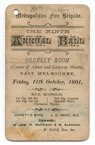
Ephemera - Dance card, Metropolitan Fire Brigade The Ninth Annual Ball, 1901
From 1845, separate and competing volunteer fire brigades were established in Melbourne and grew in number. Following the passage of the Fire Brigades Act 1890 and the creation of the Metropolitan Fire Brigade (MFB) on 1 May 1891, the 56 volunteer brigades that then existed were disbanded and the firefighters were invited to join the MFB. The MFB was abolished in 2020 and the firefighters absorbed into the newly established Fire Rescue Victoria.White coloured rectangular shaped card printed in black on both sides. Hole in top left hand corner.Front Metropolitan Fire Brigade. The Ninth Annual Ball. Orderly Room (Corner of Albert and Gisborne Streets) EAST MELBOURNE, Friday, 11th October, 1901. MFB QUADRILLE. 1st Fig. 1st Set; 3rd Fig, 1st Set; 3rd Fig. Lancers; Spanish Waltz; Circassian Figure. JARRETT'S BAND. J. C. PRICE, M. C. Stewards: MESSRS. H. HARRISON 7 R. GLENNON W. CAVE, Hon. Sec. Back: List of dances, against which some names and initials have been written by handmetropolitan fire brigade, orderly room - east melbourne, jarrett's band, 20th century, melbourne - history -
 St Kilda Historical Society
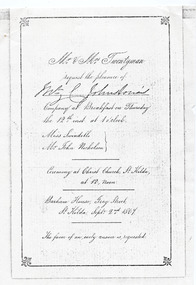
Ephemera - Invitation - wedding, Invitation to wedding of Miss Swindles and Mr John Nicholson 1867, 1867 (original)
... 51 Grey Street, St Kilda, Victoria, Australia ...The Argus, 27 September 1867 p4 - MARRIAGES: NICHOLSON—SWINDELLS.—On the 12th inst., at Christ Church, St. Kilda, by the Rev. D. Seddon, John, eldest son of the late Hon. W. Nicholson, to Gertrude Sarah, youngest daughter of the late James Swindells, Esq., of Manchester. No cards. https://trove.nla.gov.au/newspaper/article/5779002 Barham House was built in 1850 by Edward Bernard Green (1809-1861) a successful land speculator. It was a magnificent residence built in the regency style to the design of architect John Gill and set in landscaped grounds of nine acres and included an ancient Swiss cottage. When Green died in 1861, his executor was his neighbour, William Nicholson (1816-65) who owned Fernleigh immediately to the north in Grey Street, but actually lived in Barham House during his time as Premier of Victoria 1859 - 1860 until his death in 1865. In 1866 Richard Twentyman purchased Fernleigh from the Nicholson Estate and a year later he married Nicholson's widow, Sarah. Both remained at Barham House until June 1870. In 1871 the building was substantially remodelled and re-named Eildon. It is one of the larger surviving 19th century houses in Melbourne.Black and white photocopy of invitation, wedding breakfast menu and envelope(handwritten) Original in possession of Lady Johnston. (handwritten) Gerty's marriage? Invitation: Mr and Mrs Twentyman request the pleasure of [unclear] Johnstone's Company at Breakfast on Thursday the 12th at 1 o'clock. Miss Swindells Mr John Nicholson. Ceremony at Christ Church St Kilda, at 12, Noon Barham House, Grey Street, St Kilda Sept. 2nd. 1867 The favour of an early answer is requested Menu: Déjeuner Barham House, St Kilda, 12. September, 1867. Menu items listed on following page Envelope: [unclear] Johnstone Esq Care of J C Johnstone Esq Sunburybarham house, christ church, st kilda, 19th century, eildon house, grey street -
 St Kilda Historical Society
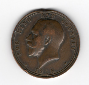
Souvenir - Medallion, ANZAC day medallion, 1916
The ANZAC Day medallion was struck by the Education Department of Victoria for school children in 1916, to commemorate the first anniversary of the ANZAC Forces landing at Gallipoli on 25 April 1915. It was issued for sale to children and the general public.Circular medallion with head of King George V facing left on obverse, and a wreath surrounding the word 'ANZAC' on the reverseObverse: FOR KING AND COUNTRY 1916 Reverse; ANZAC (surrounded by wreath) DEPT. OF EDUCATION VICTORIA LEST WE FORGET 25 APR 15 (around circumference) wwi, world war i, anzac day -
 St Kilda Historical Society
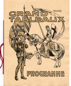
Ephemera - Concert program, Grand Tableaux Programme, 1915
An example of tableaux drama. Ten 'scenes from the Empire' were presented: King Alfred Disguised as a Harper in the Camp of the Danes'; 'The Signing of the Magna Carta'; 'Queen Elizabeth Knighting Drake on the Deck of the "Golden Hind"' etc. Contains details of Executive of the Victorian Artists' Society and the St Kilda Executive Committee. Under the patronage and in the presence of, among others, the Governor of Victoria, the Lord Mayor of Melbourne and Madame Melba. To raise funds 'to provide an Ambulance for the Australian Wounded'.Yellowed cream cardboard, printed in black and gold, folded in half to form the cover. Inside two sheets of paper, printed in black and red and folded to make four pages, are fastened to the cover by stitched red string.wwi, world war i, victorian artists' society, wwi fund-raising -
 St Kilda Historical Society
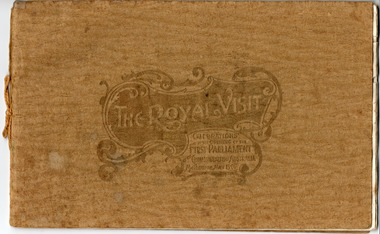
Memorabilia - Booklet, The Royal Visit Celebrations at the Opening of the First Parliament Commonwealth of Australia Melbourne May 1901, 1901
Booklet contains photographs of: THH the Duke and Duchess of Cornwall and York; Earl of Hopetoun, Governor General, and Countess; Commonwealth Ministry; The Royal Party at Government House Melbourne; TRH the Duke and Duchess Landing at St Kilda Pier; The Mayor of Melbourne Welcoming His Royal Highness at the entrance to the City; Procession Passing down Bourke Street; Presentation of War Medals to Victorian Soldiers; The Duke of York and his Staff; St Kilda and Prahran Arch; City Arch; Procession passing Princes Bridge; Opening Ceremony at First Federal Parliament; Citizens' Arch; Queen Victoria Arch; Royal Yacht Ophir; Warships Gromoboi (Russian) and Brooklyn (USA); German Arch; Chinese Arch; State School Fete at Exhibition Building; The University Commencement; Group of Fijian Constabulary; Laying Foundation Stone, Soldiers' Memorial Ballarat; Visit to South Star Gold Mine, Ballarat; Illuminations at Princes Bridge and Flinders Street Station; Illuminations at Parliament House and Treasury; Illuminations at Town Hall and City ArchGold coloured paper cover embossed and tied with gold thread. Contains 16 pages of cream coloured paper printed in black, some with blue decorative margins.Handwritten inscription on title page: 'For the Boy from Grandfather in memory of a very happy time we spent together May 1901'duke and duchess of cornwall and york, royal visits, 1901, opening of parliament, federation arch, st kilda and prahran arch, city arch, german arch, chinese arch -
 St Kilda Historical Society
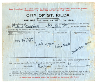
Administrative record - Form, Dog registration forms, 1915
5 blue coloured paper forms printed in black and red. Details inserted in handwritten ink.city of st kilda, dog registrations, 1890 dog act - victoria