Showing 10429 items
matching sites
-
 Whitehorse Historical Society Inc.
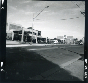
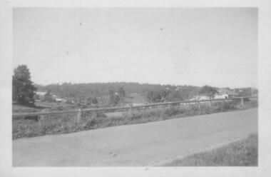
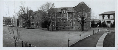
Photograph, View east side Mitcham Road, c. 1987
The site was the former medical rooms of Dr Stanley Cochrane and Dr Vernier ThrelkeldBlack and white photograph of the east side Mitcham Road, opposite Victoria Street, showing the office block, now (in 2004) occupied by Jobs East. c. 1987|See Historymitcham road, mitcham, victoria street, cochrane . stanley dr, threlkeld, verner w. dr. -
 Whitehorse Historical Society Inc.
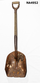
Tool - Shovel
The shovel was probably used at the Burwood Brick Works as it was found during redevelopment of the site.Large steel shovel with steel and wooden handle.Tulloch Phoenix Pat No. 51268. 11-9-51 No 7rural industry, agriculture -
 Stawell Historical Society Inc
Book - History, The People of Gariwerd, by Gib Wettenhall, 1999
Archaeology Rock Art Sites Aboriginal Heritage and History Koori Brambuk Grampians Orange and Black in Colour with Photo of sun behind mountains, Hand Prints and figure. Aurthor Gib Wettenhall Published 2019first people -
 Buninyong & District Historical Society
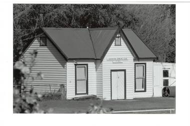
Photograph - B/W photograph, Clive Brooks, Buninyong Bowling Club, 1870's Clubhouse
C19th Bowling club, on original site, early 1870's clubhouse remains.B/W photo Buninyong Bowling Club, White painted wooden building, gabled tin roof, two tall windows, plank double doors. Greens roller on right.buninyiong, bowls, bowling club, -
 Bendigo Military Museum
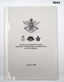
Manual - Australian Defence Force - Military Geographic Information Encyclopedia, Information Strategic Concepts Branch of the Australian Defence Force Strategic Command Division, Directorate of Strategic Military Geographic Information, 27 Aug 1998
Military Geographic Information Encyclopedia in 3 Parts- Acronyms, Definitions, Web sitesSoft Film Cover, 3 Parts (Chapters), 77 Pagesroyal australian survey corps, rasvy, fortuna, army survey regiment, army svy regt, asr -
Lakes Entrance Regional Historical Society (operating as Lakes Entrance History Centre & Museum)
Postcard, Rose Series P4145, 1945 c
Site selected by Shire in 1927 fully developed by 1937 Mrs Boyes as caretakerBlack and white postcard of Mitchell Gardens Campground Bairnsdale VictoriaThe Camping Ground Bairnsdale Vicaccommodation, businesses, hotels -
 Lakes Entrance Regional Historical Society (operating as Lakes Entrance History Centre & Museum)
Postcard, 1940
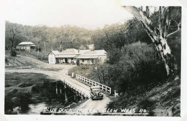
Hotel buildings moved from Omeo to present site, 1928 by William O'ConnellBlack and white postcard showing Blue Duck Hotel, Glen Wills Rd, East Gippsland, Victoria. Bridge over Mitta Mitta River, house at back, sedan car leaving bridge, dense forest surrounding.Blue Duck Hotel Glen Wills Roadbridges, boats and boating -
 Lakes Entrance Regional Historical Society (operating as Lakes Entrance History Centre & Museum)
Photograph, Holding M, 1999
Appears to have been relocated from unknown site, more research required.Colour photograph of a timber dwelling. Has high pitched corrugated iron roof, decorative timber frieze under pitch of gable over front room. Steps leading up to veranda. Set in native vegetation, at 6 Worcester Street, Lakes Entrance Victoriaaccommodation, houses, heritage study -
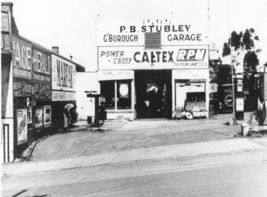
 Greensborough Historical Society
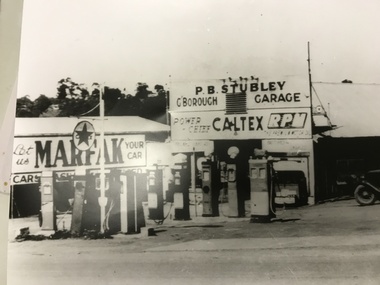
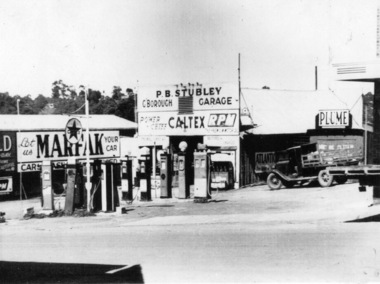
Photograph, Stubley's Garage, 1948c
Purcell Stubley bought the garage site in 1946, and this photograph would have been taken shortly afterwards. Note the multiple fuel bowsers, each selling a different brand. Watson Holden was on this site until the late 1970's. Then Woolworths constructed the current building which Savers now occupy. Part of a collection of photographic enlargements of Greensborough sites.Black and white enlargement of photographic imagestubley motors, main street greensborough, woolworths greensborough, watson holden, savers -
 Greensborough Historical Society
Photograph - Digital image, Rear of Stubley Motors, 1951_
Rear of Stubley Motors 1951. The Stubley Group began in 1946 when Purcell Stubley purchased a site with petrol bowsers in Main Street from 'Snowy' Jessop. In 1948 Purcell began building the new Stubley Motors, working round the old site to keep the business operating. It was completed in 1951.Digital copy of black and white photographpurcell stubley, stubley motors, stubley group greensborough -
 Greensborough Historical Society
Photograph - Digital image, Stubley Garage, 1946_
Stubley Garage 1946. The Stubley Group began in 1946 when Purcell Stubley purchased a site with petrol bowsers at 96 Main Street from 'Snowy' Jessop. In 1948 Purcell began building the new Stubley Motors, working round the old site to keep the business operating. It was completed in 1951.Digital copy of black and white photographpurcell stubley, stubley motors, stubley group greensborough -
Clunes Museum
Film - DVD, Nine Network Australia, Postcards - Episode 22, 2008
Visual programme featuring Widow Twankey's. a local cafe, and the Clunes Museum prior to the redevelopment of the site at 36 Fraser Street, in 2012. Interviews of Tim Hayes, owner of Widow Twankey's and Pat Cook the Curator of Clunes Museum. Images of significant sites and historic buildings as well as streetscapes and landscapes of Clunes.DVD IN WHITE PAPER SLEEVE CHANNFEL 9 POSTCARDS, EPISODE 22 "GENERAL SHOW"widow twankey's, pat cook, tim hayes, clunes museum -
 Merri-bek City Council
Photograph, Peta Clancy, Undercurrent, 2018-19
Peta Clancy is a descendent of the Bangerang people from South-Eastern Australia. She explores hidden histories of colonisation in Australia. Through manipulating photographic prints, she reconstructs these hidden histories in a contemporary setting. In 2018, Clancy was awarded the inaugural Fostering Koorie Art and Culture grant from the Koorie Heritage Trust. The grant enabled her to collaborate with the Dja Dja Wurrung community to create a body of work investigating massacre sites on Dja Dja Wurrung country. The exhibition Undercurrent at the Koorie Heritage Trust focussed on a massacre site submerged under water. Clancy says of the exhibition and this work: ‘I explored this site as a metaphor for the hidden history of many massacres throughout Australia and the denial of this aspect of our history and the trauma these sites evoke’. -
 Greensborough Historical Society
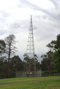
Photograph - Digital Image, Marilyn Smith, Air Navigation Facility, Montmorency, 2018. Tower, 04/12/2018
Air Navigation Facility, Palara Court Montmorency, is made up of a tower and brick building surrounded by wire fences. It is sited in parkland at the end of Palara Court close to the Plenty River Trail. Warning signs are placed on the fences, including: "This facility is provided for the control and guidance of aircraft". This photograph shows the tower on the site.Digital copy of colour photographsair navigation facility, air control, palara court montmorency -
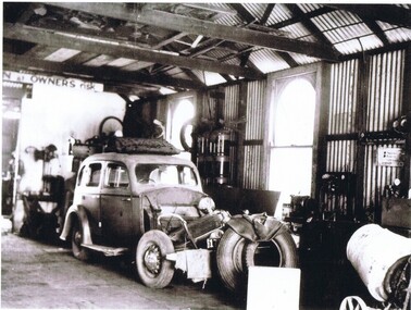
 Greensborough Historical Society
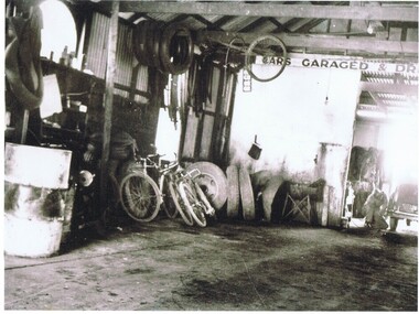
Photograph - Digital image, Stubley Garage - Interior View 1946, 1946_
Interior view of Stubley Motors 1946. The Stubley Group began in 1946 when Purcell Stubley purchased a site with petrol bowsers in Main Street from 'Snowy' Jessop. In 1948 Purcell began building the new Stubley Motors, working round the old site to keep the business operating. It was completed in 1951.Digital copy of black and white photographpurcell stubley, stubley motors -
 Greensborough Historical Society
Photograph - Digital image, Stubley Garage - Interior View 1946, 1946_
Interior view of Stubley Motors 1946. The Stubley Group began in 1946 when Purcell Stubley purchased a site with petrol bowsers in Main Street from 'Snowy' Jessop. In 1948 Purcell began building the new Stubley Motors, working round the old site to keep the business operating. It was completed in 1951.Digital copy of black and white photographpurcell stubley, stubley motors, stubley group greensborough -
 Greensborough Historical Society
Photograph - Digital Image, Stubley Garage, 1946_
Stubley Garage 1946. The Stubley Group began in 1946 when Purcell Stubley purchased a site with petrol bowsers at 96-104 Main Street from 'Snowy' Jessop. In 1948 Purcell began building the new Stubley Motors, working round the old site to keep the business operating. It was completed in 1951.Digital copy of black and white photographpurcell stubley, stubley motors, stubley group greensborough -
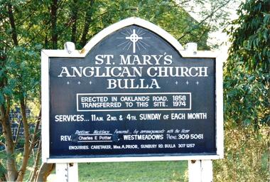 Hume City Civic Collection
Photograph, late 1990s
St. Mary's Anglican Church at Bulla was originally built on the outskirts of Bulla township in 1858. In the early 1970s it was moved to its present site to make way for the flight path at the newly constructed Tullamarine Airport. The former site was on the corner of Oaklands and Sunbury Roads and is covered with vegetation. The church was designed by Thomas Taylor.A coloured photograph of the board which is along the fence line outside St. Mary's Church at Bulla. The white writing is on a navy blue background and is framed in white. The notice gives details of services, clergy and caretaker.churches, religion, anglican church, taylor, thomas, potter, charles e. rev., prior, a., st. mary's anglican church, george evans collection -
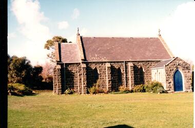 Hume City Civic Collection
Photograph, late 1990s
St. Mary's Anglican Church at Bulla was originally built on the outskirts of Bulla township in 1858. In the early 1970s it was moved to its present site to make way for the flight path at the newly constructed Tullamarine Airport. The former site was on the corner of Oaklands and Sunbury Roads and is covered with vegetation. The church was designed by Thomas Taylor.A profile view of the west side of St. Mary's Anglican Church at Bulla and the garden area around the church. A slate covered gable roof has been constructed over the porch nave and chancery with a cross at each end of the roof over the nave. 6 bluestone buttresses and 3 lance windows are along the side with 3 small lancet windows and a blue painted wooden lancet door on the porch.churches, religion, taylor, thomas, st. mary's anglican church, george evans collection -
 Old Colonists' Association of Ballarat Inc.
Photograph - Photograph - Colour, Ballarat Old Colonists' Association Homes, Charles Anderson Grove, Ballarat
HISTORY OF THE BALLARAT OLD COLONISTS' ASSOCIATION HOMES AT CHARLES ANDERSON GROVE, LAKE GARDENS One of the original objectives of the Association was “to provide the shelter of a house for those Pioneers of the Goldfields whom the reverses of fortune have deprived of the means of procuring the comforts of life in their declining years.” While the first home at Charles Anderson Grove was built in 1925 the Association had previously provided relief for needy pioneers from the time it was formed in 1883. Relief included monthly monetary payments, loads of firewood, medical assistance and distribution of Christmas boxes of groceries to deserving pensioners and in some cases payment of burial costs. Records indicate that in September 1922 three of the pensioners being assisted by the Association were accepted as residents in the newly erected Hassell Homes in Gillies Street (now demolished-opposite the High School). The first site for an Asylum for Indigent Members of the Old Colonists' Association was temporarily reserved from sale in October 1891. The site was approximately 28 acres in area in Mt Clear nearly opposite Midvale Shopping Centre in Main Road. The site was heavily timbered and when cleared over 260 tons of wood was sold to the Woah Hawp Gold Mining Company. A set of gates were erected but no homes built, although a plan for this reserve was drawn which showed twenty buildings ranging from one to four unit per building. The reserve was revoked in November 1909. The second site temporarily reserved in November 1909 as an Asylum was in Alfredton and consisted of some 7 acres and was adjacent to land reserved for an Abattoirs for the Ballarat Council. The reserve was revoked in February 1912 as it was deemed more appropriate to be added to the Abattoir site. Council suggested four (4) other sites in exchange for this land and they were inspected by the President, Vice President and Secretary on 22 December 1912. The first site inspected was land on the west side of Creswick Road opposite the brick kilns (now occupied by the showgrounds and oval). The land was described as being good quality, well fenced, no trees, good drainage and ample acreage but some distance from trams. The second site was Perry Park which was described as being good land, well fenced, having frontage to Gillies Street, good drainage and about 26 acres (but subsequently reduced to 10 acres). It was closely planted with Pinus Insignias and Wattle and had easy access from the Botanic Gardens tram. The third site was the North West portion of Victoria Park (corner of Sturt and Gillies Street) and was described as good land, well fenced and drained and well located. The fourth site was the South West corner of Victoria Park and known as Pound Paddock (corner of Winter Street and Gillies Street). It was considered to be low lying and too close to the Abattoir, and was also a considerable distance from trams. While the third site was recommended as the most suitable for the erection of homes it was considered unwise from the point of view as citizens to reduce the acreage of the park and therefore it was recommended that the Perry Park site be asked for as the most acceptable to the Association for the building of homes. The site was eventually temporarily reserved for an Asylum for Indigent Members of the Association in April 1914 with the gates from Mt Clear having been removed to the site a year earlier and eventually erected in 1917 for £12.10.0. In the same year the first 290 pine trees were advertised for removal in July and sold for £16. A sign indicating that the site was reserved for the erection of cottages was erected in September 1917. Stripping of the wattle bark (for tanning) and the cutting of the wood occurred in November 1918 with the land then being leased until it was required for the construction of the first homes in 1924. While the site was the third to be reserved it was the only one which was used for its intended purpose. It was named as Charles Anderson Grove in honour of Charles Anderson who joined the Association in 1918 and was President of the Association from 1942 to 1944. A number of cottages in the Ballarat Old Colonists' Association Retirement Village of Gillies Street, Ballarat.charles anderson grove, old colonists' club, ballarat, old colonists' association, old colonists' homes, retirement village -
 Vision Australia
Photograph - Image, Demolition of Raleigh Street premises, 200
On September 23, 1925 the State Goverment gazetted a transfer of land in Raleigh Street, Prahran to RVIB. This was used to establish a hostel for women apprentices and workers, and building commenced in 1926 and was completed in 1927, at a cost of 3500 pounds. Demand for accommodation was strong and in 1929 a hostel for men was completed. The building were used as hostels for many years, but as demand decreased, the Institution found other ways to utilise the buildings. In 1972, a plant nursery was established on the site and other departments temporarily used the site. In 1994 the Employment Services team moved out of the building and the site was sold to developers.17 col. images of the partially demolished house at Raleigh Street, Prahranroyal victorian institute for the blind, raleigh street hostel -
 Eltham District Historical Society Inc
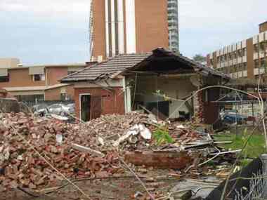
Document - Series Listing, Fraser Faithfull et al, Series 21: Eltham Library construction, 300 photographs, sketch plans, 2000
Series consists of I) 7 sepia toned photographs or Librarian Linda McConnell inspecting work on the site orthe new library. 2) 11 B& W, sepia and colour photographs or work on the site. 3) 3 laminated colour sketches: floor plan, roor plan & exterior 4) A set or approximately 280 colour snapshots documenting work on the construction site, arranged chronologically month-by-month. There are also 5 "panorama" panels or between 2-4 snapshots taped together. These have been mounted on acid-free card.shire of eltham archives, series listing -
 Whitehorse Historical Society Inc.
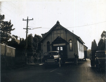
Photograph, Methodist Church Mitcham, 1/06/1967 12:00:00 AM
1888 First Wesleyan church erected on the East corner of Richards St and Whitehorse Rd. 1021 Church was transferred and enlarged on Mitcham Rd. site. 1932 Church was extended Westward. Kindergarten room was extended east to form Wesley Hall. 1953 Church connected to Wesley Hall. 1957 house next to Church purchased. 1958 Community Hall opened. Presbyterian site used by both denominations. 1967 old Methodist site closes, Church building and Wesley hall transferred to Doncaster East and these photos show the Church being moved.Church being moved to Doncaster East. Man on the roof lifting power linesmethodist church mitcham, churches -
 Greensborough Historical Society
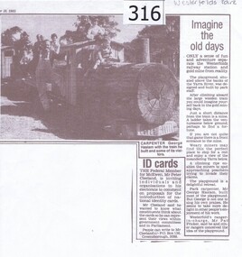
Newspaper clipping, Diamond Valley Leader, Imagine the old days, 10/09/1985
News article relating the opening of a 'gold mining' site and wooden train at Westerfolds Park.Photocopy of article from Diamond Valley News 1985. Includes photograph of children on miniature train.westerfolds park, gold mine, parks, playgrounds, george haslam, yarra river -
 Greensborough Historical Society
Photograph - Digital image, Nance Reardon, Grimshaw Street looking from the Simons' house 1950s, 1950s
Photograph of Grimshaw Street looking from the Simons' house. The WaterMarc complex is now on this site.Digital copy of black and white photograph.simons family, grimshaw street greensborough, watermarc -
 Greensborough Historical Society
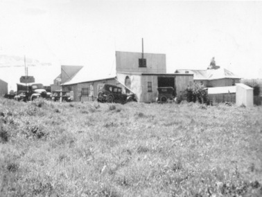
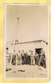
Photograph - Digital Image, Mystery mine photographs: Building staff quarters with men outside, 1935c
This photograph shows the workers huts at the mine site, nearing completion, with men standing outside..An interesting collection of photographs, the connection to Greensborough remains a mystery. Digital copy of black and white photograph, one of 30 photos of mining operations. Photos have no markings or dates. Donor unknown.tasmania, mines and mining, mining machinery -
 Greensborough Historical Society
Document, Victoria. Department of Environment Land Water and Planning, Proposed planning changes for Austin Hospital, 28/10/2016
Information on proposed changes to heritage overlays on the Austin Hospital site on Studley Road Heidelberg4p. coloured information sheet, with one page covering letter from the Government Land Standing Advisory Committeeaustin hospital -
 Federation University Historical Collection
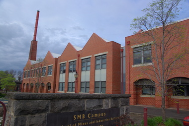
Photograph, Clare Gervasoni, Brewery Complex at Federation Australia SMB Campus, 2011, 06/10/2011
The brewery building was built on the site of the Ballarat Brewery. It is part of the Ballarat School of Mines Campus.Photographs of a red brick building with large chimney. The building is the Brewery Complex at Federation University Australia SMB Campus. The chimney is a remnant for the Ballarat Brewery. federation university, federation university australia, feduni, smb campus, ballarat school of mines, brewery complex, ballarat brewery, buildings -
 Federation University Historical Collection
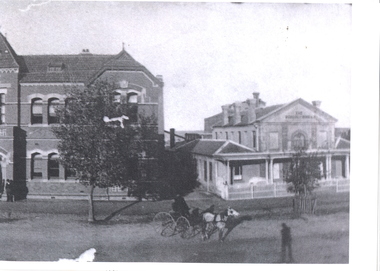
Photograph - Photograph - Black and White, School of Mines Ballarat; c1910, c1910
The former Ballarat Circuit Courthouse was used as the first site of the Ballarat School of Mines in 1870.Black and white photograph of two buildings at the Ballarat School of Mines. The one on the right is the former Ballarat Circuit Court House which was demolished to make way for the Ballarat Technical Art School (Gribble Building). The building on the left was orginally known as the New Classrooms and were opened in 1901. It is now known as the Administration Building (A-Building).ballarat school of mines, administration building, new classrooms, ballarat circuit court house, lydiard street south -
 Federation University Historical Collection
Photograph - Photograph - Black and White, Ballarat School of Mines, c1980s, c1910
The Ballarat School of Mines was estabished in 1870, making it the first site of technical education in Australia. Ballarat School of Mines from Lydiard Street South. From left to right - the Ballarat Uniting Church, School of Mines Museum (Former Wesleyan Church), New Classrooms and Administration Building, Ballarat Technical Art School, Gaol Governor's residence.ballarat school of mines, ballarat school of mines museum, former wesleyan church, lydiard street south, ballarat technical art school, governor's residence