Showing 23712 items
matching creeks
-
 Ballarat Tramway Museum
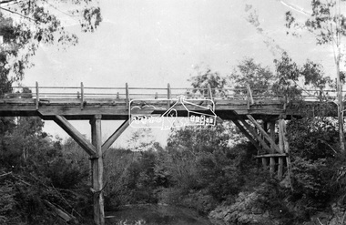
Photograph - Black & White Photograph/s, Wal Jack, 10/04/1950 12:00:00 AM
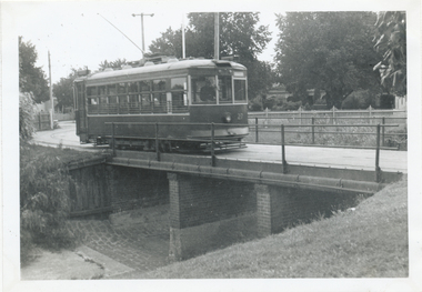
Black and White print contained within the Wal Jack Bendigo and Geelong Album, see Reg Item 5003 for more details. Photo of Bendigo Birney No. 27 crossing the bridge entering the depot 10-4-1950, Photo by Wal Jack. Printed on Ilford paper. i1 - scan of print in the album i2 - rear of image i3 - scan of negative at 3200dpi added 6/6/2020. On the rear in blue ink "SEC Bendigo Birney #27 crossing over creek near depot 10-4-50" with Wal Jack copyright stamp in the top right hand corner and the number "T210" written in.trams, tramways, bendigo, depot, birney, tram 27 -
 Ringwood and District Historical Society
Newspaper, Scrapbook Clipping, Library Collection, Ringwood, Victoria
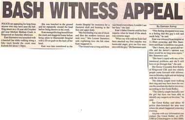
Newspaper Clipping from "The Post", 13 October,1993, page 1. "Bash witness appeaL"'.Police are appealing for help from anyone who may have seen the baffling attack on a 16 year old Croydon girl near Mullum Mullum Creek. Kate Stammers was assaulted with a baseball bat. She was knocked to the ground and hit repeatedly around the head before being thrown in the creek. She was taken to Maroondah Hospital with a 30 cm gash on the back of her head, before being transferred to the Austin Hospital for treatment for a fractured skull; and bruising to the face and the upper body. -
 Orbost & District Historical Society
black and white photograph, late 19th century - early 20th century
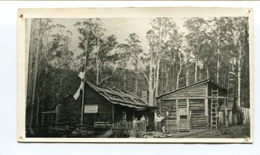
Peter Jensen came to Martin's Creek (35 miles north of Orbost) in 1890 having been told that Martin's Creek would be on the railway line. He was a cooper who made the casks from silver wattles. He cleared the area for farming and then built an accommodation house, Danebo., which was well used by travellers to Bonang and Bendoc. . Gippsland was a relatively less developed part of Victoria in the nineteenth century. Danebo Hotel, Martin’s Creek, would have been an important stopping point for travellers to Bonang and Bendoc. The hotel is no longer standing A black / white photograph of a timber building - a house and another building at an angle. There are three people standing in front - a man. woman and child. On the left is a flag on a mast. In the background is bush.danebo-hotel-martins-creek jensen-peter -
 Greensborough Historical Society
Map, Melbourne and Metropolitan Board of Works. Survey Division, MMBW, Yarra 2500 / 14.23. Diamond Creek, Sutherland Homes, 1979_05
Melbourne and Metropolitan Board of Works. Yarra 2500 [base map] 14.23. Diamond Creek, Sutherland Homes. Parish of Morang 3183 and Nillumbik 3310. Municipality of Diamond Valley 257. Prominent streets Aqueduct Road, Diamond Creek Road, Yan Yean Road and McLaughlans Lane. Features include the abandoned Maroondah aqueduct and Sutherland Cottages.MMBW Map in 1:2500 [scale] series. Cream parchment with green tape reinforcing on edges and punched holes on left edge.mmbw, melbourne and metropolitan board of works, shire of diamond valley, plenty - maps, sutherland homes, maroondah aqueduct -
 Eltham District Historical Society Inc
Photograph, Diamond Creek Gold Mine
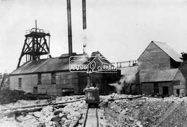
Situated at the end of Fraser Street, Diamond Creek. The Diamond Creek Gold Mine was the largest in the Diamond Valley Shire with a shaft depth of over 290 metres at the peak of its development in 1915. The surface plant was quite large with four boilers and five steam engines working the battery, winder, water pump, air compressor and lighting generator.This photo forms part of a collection of photographs gathered by the Shire of Eltham for their centenary project book, "Pioneers and Painters: 100 years of the Shire of Eltham" by Alan Marshall (1971). The collection of over 500 images is held in partnership between Eltham District Historical Society and Yarra Plenty Regional Library (Eltham Library) and is now formally known as 'The Shire of Eltham Pioneers Photograph Collection.' It is significant in being the first community sourced collection representing the places and people of the Shire's first one hundred years.Digital imagesepp, shire of eltham pioneers photograph collection, diamond creek, goldmine, gold mine, poppet head -
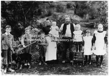 Eltham District Historical Society Inc
Negative - Photograph, Sabina and Will Mills and family, Upper Diamond Creek (Wattle Glen), c.1899
Sabina and William Henry Mills lived at "Golden Valley", Upper Diamond Creek (Wattle Glen) and had nine children in total. Here they are pictured with seven young children. Sabina died in 1916 aged 57 and William died in 1921 age 64. They are buried together at Diamond Creek (Nillumbik) cemetery. Reproduced on p46 of 'Pioneers & Painters'This photo forms part of a collection of photographs gathered by the Shire of Eltham for their centenary project book, "Pioneers and Painters: 100 years of the Shire of Eltham" by Alan Marshall (1971). The collection of over 500 images is held in partnership between Eltham District Historical Society and Yarra Plenty Regional Library (Eltham Library) and is now formally known as 'The Shire of Eltham Pioneers Photograph Collection.' It is significant in being the first community sourced collection representing the places and people of the Shire's first one hundred years.Digital image 4 x 5 inch B&W Neg 20 x 25 cm printsepp, shire of eltham pioneers photograph collection, wattle glen, sabina mills, will mills, mills family, pioneers and painters, upper diamond creek -
 Stawell Historical Society Inc
Archive, Archives from Pleasant Creek Training Centre
-1 Large Ledger 1943 Tools & Consumables for Manual Training Class. -2 Pleasant Creek Special School, School Policy and Curriculum 1947 -3 2 X WEL magazines 1983 -4 Test Material for the Measurement of Intelligence -5 Invitation for registration of expression of interest for Former Pleasant Creek Centre at Western Highway Stawell.Large Green Ledger with Brown Spine. Yellow covered Book with black binding combs. Two A3 Sized Negative Booklets. Two sets of Intelligence Test Material. Expression of Interest for site.education -
Hume City Civic Collection
Photograph, Jacksons Creek Viaduct
The four arch railway bridge, known as the Jacksons Creek Viaduct Bridge, spans the Jacksons Creek north of the Sunbury Railway Station. The weir at the base of the bridge was used to dam water as well as ensuring a water supply for the steam trains. The pump house at the base of the bridge was where the water was pumped and then taken to the railway station for the steam engines.This bridge is one of notable four railway bridges along the railway line that are in Sunbury. An enlarged black and white photograph with a white border of a high bridge over a watercourse.bridges, jacksons creek viaduct, jacksons creek viaduct bridge, railways -
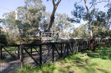 Eltham District Historical Society Inc
Photograph, Peter Pidgeon, Manna Gum, Main Road Bridge, Eltham South, 8 Sep. 2021
This significant tree located near the Main Road Bridge and Diamond Creek Trail footbridge over the Diamond Creek at Eltham dates back to the early 1900s. The original timber bridge over the Diamond Creek was built around 1840. It was destroyed by floodwaters in October 1923. A temporary bridge was rigged up but further damaged in April 1924. A new concrete bridge was built and opened in October 1926. The bridge decking was widened along with Main Road to Dalton Street by the Road Construction Authority in 1984., The uygraded bridge was opened in October 1984, 78 years after its original opening.These trees are not only significant for the natural environment but also present a navigational beacon back in time as the environmental landscape is developed around them.Born Digitaleltham south, main road bridge, manna gum, significant tree, diamond creek trail -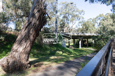
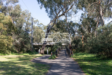
 Eltham District Historical Society Inc
Photograph, Peter Pidgeon, Manna Gum, Main Road Bridge, Eltham South, 8 Sep. 2021
This significant tree located near the Main Road Bridge and Diamond Creek Trail footbridge over the Diamond Creek at Eltham dates back to around 1870-1880. The original timber bridge over the Diamond Creek was built around 1840. It was destroyed by floodwaters in October 1923. A temporary bridge was rigged up but further damaged in April 1924. A new concrete bridge was built and opened in October 1926. The bridge decking was widened along with Main Road to Dalton Street by the Road Construction Authority in 1984., The uygraded bridge was opened in October 1984, 78 years after its original opening.These trees are not only significant for the natural environment but also present a navigational beacon back in time as the environmental landscape is developed around them.Born Digitaleltham south, main road bridge, manna gum, significant tree, diamond creek trail -
 Eltham District Historical Society Inc
Photograph, Peter Pidgeon, Manna Gum, Main Road Bridge, Eltham South, 8 Sep. 2021
This significant tree located near the Main Road Bridge and Diamond Creek Trail footbridge over the Diamond Creek at Eltham dates back to around 1870-1880. The original timber bridge over the Diamond Creek was built around 1840. It was destroyed by floodwaters in October 1923. A temporary bridge was rigged up but further damaged in April 1924. A new concrete bridge was built and opened in October 1926. The bridge decking was widened along with Main Road to Dalton Street by the Road Construction Authority in 1984., The upgraded bridge was opened in October 1984, 78 years after its original opening.These trees are not only significant for the natural environment but also present a navigational beacon back in time as the environmental landscape is developed around them.Born Digitaleltham south, main road bridge, manna gum, significant tree, diamond creek trail -
 Eltham District Historical Society Inc
Photograph, Peter Pidgeon, Manna Gum, Main Road Bridge, Eltham South, 8 Sep. 2021
This significant tree located near the Main Road Bridge and Diamond Creek Trail footbridge over the Diamond Creek at Eltham dates back to the early 1900s. The original timber bridge over the Diamond Creek was built around 1840. It was destroyed by floodwaters in October 1923. A temporary bridge was rigged up but further damaged in April 1924. A new concrete bridge was built and opened in October 1926. The bridge decking was widened along with Main Road to Dalton Street by the Road Construction Authority in 1984., The uygraded bridge was opened in October 1984, 78 years after its original opening.These trees are not only significant for the natural environment but also present a navigational beacon back in time as the environmental landscape is developed around them.Born Digitaleltham south, main road bridge, manna gum, significant tree, diamond creek trail -
 Eltham District Historical Society Inc
Photograph, Hurst's Bridge, c.1912
The area of Hurstbridge was originally known as Hurst’s-bridge after the timber bridge built over the Diamond Creek near Hurst’s station in late 1881/early 1882 on Hurstbridge-Arthurs Creek Road, Hurstbridge. It was built by John McDonald, of Arthur's Creek and was demolished and replaced in 1917 by a reinforced concrete arch bridge designed by John Monash. Part of a slide show presentation "Bridges & Waterways of the Shire" by Russell Yeoman to the 13 September 1989 Society meeting. The presentation included slides of historic photos from the Shire of Eltham Pioneers collections as well as several recent views. This photo forms part of a collection of photographs gathered by the Shire of Eltham for their centenary project book, Pioneers and Painters: 100 years of the Shire of Eltham" by Alan Marshall (1971). The collection of over 500 images is held in partnership between Eltham District Historical Society and Yarra Plenty Regional Library (Eltham Library) and is now formally known as 'The Shire of Eltham Pioneers Photograph Collection.' It is significant in being the first community sourced collection representing the places and people of the Shire's first one hundred years.Digital imageshire of eltham pioneers photograph collection, 1912, bridge, diamond creek (creek), hurstbridge, hurst's bridge -
 Orbost & District Historical Society
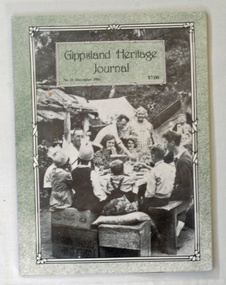
book, E-Gee Printers Pty Ltd, Gippsland Heritage Journal, December 1991
Gippsland Heritage Journal is a journal, produced about every nine - twelve months, for those interested in regional, local and family history in Gippsland, Victoria, Australia. It is compiled by Meredith Fletcher, Debbie Squires and Linda Barraclough and includes a diverse range of articles, both academic and non-academic. Since No.24 it has been a partially refereed journal. This copy was used in the library of Orbost Secondary College. This item is a useful reference tool on the history of Gippsland.A 64 pp magazine, titled Gippsland Heritage Journal No 11 (December 1991). It cost $7.00. The front cover is light green with a b/w photograph of a birthday party for one of the children at Black Snake Creek about 1937. The magazine contains photographs, articles on the history of Gippsland, -
 Bendigo Historical Society Inc.
Document - NOTES ABOUT THE LIFE OF REV MICHAEL CLARKE, 29/3/2007
Document, Rev.Michael Clarke was a Primitive Methodist Minister who was stationed at Castlemaine, Campbell's Creek, and Eaglehawk during the 1850's and 1860's, and one of his sons married into the Avery family of Bendigo. Letter offering Tin Trunk to BHS. Tin Trunk in shipping container 20.1.2022Ian Clarkereligions, christian, primitive methodist -
Bendigo Historical Society Inc.
Map - EGERTON : COUNTY OF BENDIGO, 1-3-30
Map. Egerton, County of Bendigo, Minto, Diggorra, Elmore, Nolan, Goornong, Bagshot, Whirrakee. Bendigo Creek. By authority J.J. Green, Govt. Printer. Photo-Lithographed at the Department of Lands and Survey, Melbourne. Price 2/-. 1-3-30. (number 47 in map cupboard 1)J.J. Green, Govt. Printer.map, bendigo, egerton -
 Bendigo Historical Society Inc.
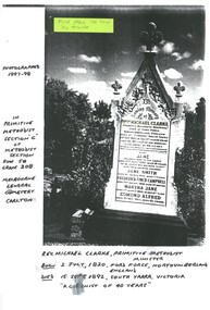
Document - PHOTOGRAPH OF HEADSTONE OF REV MICHAEL CLARKE, 1997
Copy of a photograph of the headstone of Rev.Michael Clarke who was a Primitive Methodist Minister who was stationed at Castlemaine, Campbell's Creek, and Eaglehawk during the 1850s and 1860s, and one of his sons married into the Avery family of Bendigo. Buried at Melbourne General Cemetery. Tin Trunk in shipping container 20.1.2022Ian Clarkereligions, christian, primitive methodist -
 Bendigo Historical Society Inc.
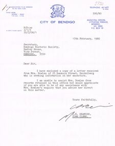
Document - BOWLEN (BOWLAN?) FAMILY: CORRESPONDENCE RE FAMILY HISTORY, 1980
Bowlen (Bowlan?) family - correspondence on enquiry from Mrs Philomena Bowlen, Heidelberg, 1980. re Family History. Seeking information - mention of Edward Timothy Bowlen (born ca. 1856 at Sandhurst or Eaglehawk). Son was John Bowlen (first white baby born at Back Creek?).person, family, bowlen family, edward timothy bowlen (bowlan), silver mines hotel. -
Whitehorse Historical Society Inc.
Legal record - Correspondence, Goldfields and mineral districts of Victoria, 1985
Letter from the State Library of Victoria about location of a gold mime near Koonung Creek in Box Hill North with a reef 2 feet in thickness which yielded 1oz per ton.Letter from the State Library of Victoria about location of a gold mime near Koonung Creek in Box Hill North with a reef 2 feet in thickness which yielded 1oz per ton. Information from R. Brough Smyth 'Goldfields and mineral districts of Victoria'. - 1869Letter from the State Library of Victoria about location of a gold mime near Koonung Creek in Box Hill North with a reef 2 feet in thickness which yielded 1oz per ton. mines and mining, state library of victoria, jackson avenue, box hill north, goldmining -
 Whitehorse Historical Society Inc.
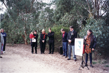
Photograph, Opening of Whitehorse Heritage Trail, 2/07/2001 12:00:00 AM
Heritage Trail funded by grant to the City of Whitehorse from Commonwealth of Australia to celebrate 100 years of Federation.Coloured photograph of Koori Representative speaking at opening of Whitehorse Heritage Trail at Gardiners Creek Reserve, Burwood. From left, Cr. Bill Bowie, Mayor of Whitehorse, Cr. Bernie Millane, Geoff Pascoe, City of Whitehorse, Cr. Kaele Way, and Anna Burke, MHR for Chisholm.whitehorse heritage trail, city of whitehorse, bowie, bill, millane, bernie, pascoe, geoff, way, kaele, burke, anna -
 Whitehorse Historical Society Inc.
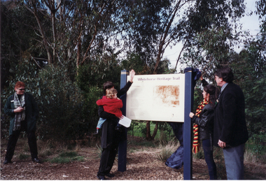
Photograph, Opening of Whitehorse Heritage Trail, 2/07/2001 12:00:00 AM
Heritage Trail funded by grant to the City of Whitehorse from Commonwealth of Australia to celebrate 100 years of Federation.Coloured photograph of Anna Burke, MHR, for Chisholm, and the Koori representative unveiling the Display Panel at opening of Whitehorse Heritage Trail at Gardiners Creek Reserve, Burwood. On Right: Cr. Bill Bowie, Mayor City of Whitehorse|On left: Lois Binnie, Heritage & Leisure Manager, City of Whitehorsewhitehorse heritage trail, city of whitehorse, burke, anna, bowie, bill, binnie, lois -
 Whitehorse Historical Society Inc.
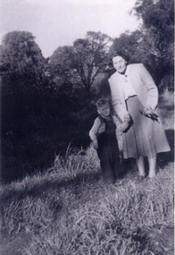
Photograph, Antonio Park - Doris Harris, C1960
The photo is part of a set provided by Robin Harris of his early life (1953-1962) in 'The Shack' at Antonio Park. See ND5241 for his story 'When Antonio Park was home'.)Black & white photograph of Doris Harris (1900-1975) with her grandson, and Robin Harris's nephew, Mark Coleclough. Photo was taken from the eastern side of the shack looking toward Deep Creek Road and showing part of the overgrown fruit orchard in the background. See ND5241 for history.antonio park mitcham, harris. dorothy, coleclough. mark, the shack, whitehorse road, mitcham, no.627, harris. robin, bushfire - 1962 -
 Bendigo Historical Society Inc.
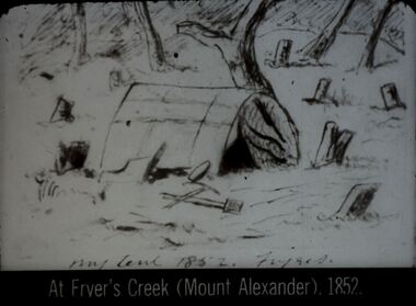
Slide - DIGGERS & MINING. DIGGERS AND MINERS, c1852
Diggers & Mining. Diggers and miners. At Fryer's Creek (Mount Alexander) 1852. Slide; My tent 1852 Fryers St. Shows miners' tent amongst trees some of which have been cut down. Markings: 43 994:LIF I. Used as a teaching aid.hanimounteducation, tertiary, goldfields -
 Bendigo Historical Society Inc.
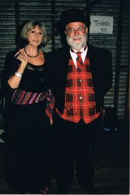
Photograph - PETER ELLIS COLLECTION: PETER ELLIS AND MARG HOGAN
Colour photograph. Man in tartan waistcoat and tie. Woman in long black dress, coloured sash. Corrugated iron wall behind them with toilets boys sign on wall. Back of photo reads: Wedderburn Old Timers Marg Hogan Peter Ellis also Emu Creek.entertainment, dance, bush dance -
 Bendigo Historical Society Inc.
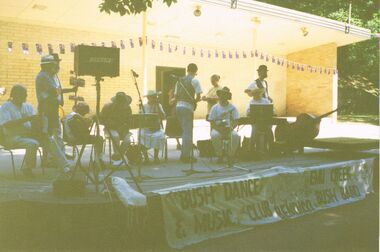
Photograph - PETER ELLIS COLLECTION: EMU CREEK BUSH BAND
Colour photograph. Quite hard to see, photo too dark. Band on stage outside. Banner reading 'The Bush Dance & Music Club of Bendigo with the Emu Creek Bush Band'. Australia flag bunting. Back of photo reads: 5A Sound Shell Rosalind Park Bendigo.entertainment, music, emu creek bush band -
 Bendigo Historical Society Inc.
Ephemera - The Sun Newspaper Sunbeams Club Envelopes and Awards, 1943
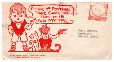
Parry Collection ‘Sunbeams’ and ‘Corinella’ were two of the few ways an Australian kid could get some acknowledgement and a pat on the back from the big wide world from the 1930s through to the 1950s. The Corinella columns ran in the Sun Newspaper with puzzles, jokes and colouring competitions. Kath Farmer played the role of ‘Corinella’ for yonks and hosted annual ‘Corinella’ Parties for boys and girls aged 5 to 13 years for decades. Sunbeam Certificates were awarded to young readers for good puzzles, riddles, drawings or original stories or verses. The Sun Newspaper Sunbeams Club Envelopes and Awards, envelopes with Ginger Meggs effigy and warning for the postman to take care with the delivery; various certificates received in return for colouring competitions and puzzles submitted back to the Sun Newspaper. Letters were sent to Merle Symons, Orville, Murphys Creek.history, bendigo, sunbeam club sun newspaper, merle lummis collection -
 Kew Historical Society Inc
Photograph - Flooding of the Yarra Valley at Kew East, 1974
Flooding of the Yarra Valley, including that section of the Yarra bordering Kew and Kew East in the north and west of the municipality, was a regular occurrence. Extreme flood events of the Yarra River are recorded to have occurred in 1891, 1901, 1916, 1923 and 1934. The Municipality of Kew's response to these floods was to enact planning decisions restricting residential development in flood prone areas following the floods of 1916, 1921 and 1934. While floods continued after the development of the Upper Yarra Reservoir (construction 1948-57), the regularity and extent of these inundations diminished. During the nineteenth century, the land abutting the south side of the Yarra in Kew was devoted to dairy farming. In the twentieth century, before and after the construction of the Eastern Freeway, much of this low-lying area was used as golf courses and public parks.Late example of the capacity of the Yarra Valley at Kew to flood, even though drainage works and the Upper Yarra Reservoir had reduced their regularity.Original black and white print photograph of the low-lying land at East Kew under floodwater on 16 May 1974. The vantage point of the photographer is Lister Street. In the photo, the fences of the Kilby Farm can be seen. Flooding was caused by overflowing water in Glass' Creek and the River Yarra. Annotation verso: "Hay's Paddock op No.30 Lister Street / 16 May 1974 11.50am / R.L. 46.04"hays paddock, floods, yarra river, glass' creek, lister street