Showing 11366 items matching "land-clearing"
-
 Whitehorse Historical Society Inc.
Document, Archie's Story, 1998 ?
Brief history on Eastside Plants (Archies Cafe, Nunawading). Land previously site of market garden owned by Archie McArthur. After Archie's death in late1990's, his house was converted into Archies Cafe.pioneers, market gardens, plant nurseries, eastside plants, archies cafe, mcarthur, archibald, gourlay, robert, lalor, peter -
 Whitehorse Historical Society Inc.
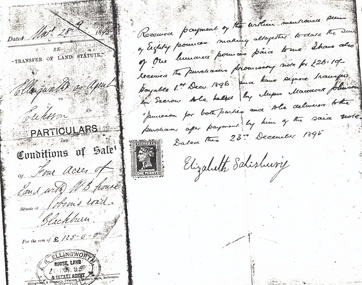
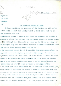
Document, Jobson's Road, 28/12/1895
Part of contract of sale between Elizabeth Salisbury (Vendor) and Eriksson (purchaser) of four acres of land with weatherboard house at Jobson's RoadPart of contract of sale between Elizabeth Salisbury (Vendor) and Eriksson (purchaser) of four acres of land with weatherboard house at Jobson's Road, Blackburn (now Junction Road, Blackburn North), 28 December 1895.Part of contract of sale between Elizabeth Salisbury (Vendor) and Eriksson (purchaser) of four acres of land with weatherboard house at Jobson's Roaderiksson, salisbury, elizabeth, jobson's road, blackburn, junction road, blackburn north, land sales -
Whitehorse Historical Society Inc.
Article, Housing plan for reserve, 2012
VicRoads has earmarked large parts of the Healesville Freeway Reservation for housing under concept plans for the land's future.VicRoads has earmarked large parts of the Healesville Freeway Reservation for housing under concept plans for the land's future. Some community groups and Whitehorse Council are calling for the entirety of the reserve to be preserved as open space.VicRoads has earmarked large parts of the Healesville Freeway Reservation for housing under concept plans for the land's future. healesville freeway reservation, whitehorse -
Whitehorse Historical Society Inc.
Document, Lee Parade, 1/11/1960
Lee Parade/Barkly Terrace area land use study, City of Nunawading. Review and recommendations by Hassell Planning Consultants Pty. Ltd., November 1960. In the folder correspondence, petitions and submissions from residents.land use, hassell planning consultants, lee parade, mitcham, barkly terrace, mitcham, whitehorse road, mitcham, church street, mitcham -
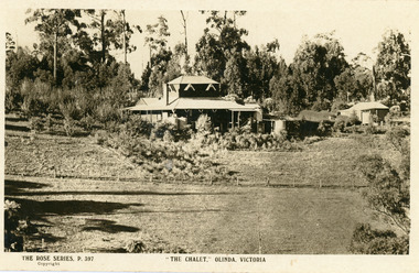 Mt Dandenong & District Historical Society Inc.
Photograph, The Chalet, Olinda, Victoria
Rose Series Postcard depicting "The Chalet" guest house at Olinda. Built c1906, The Chalet was situated at the southern corner of Chalet and McCarthy Roads. The building was destroyed by fire in 1935 and Ted Woolrich acquired the land.On front: The Rose Series P. 397the chalet, rose series, olinda, guesthouse, guest house -
 Southern Sherbrooke Historical Society Inc.
Photograph - Photos of house and land at 12c Black Hill Rd, Menzies Creek
Photographs of the house and land at 12c Black Hill Rd, Menzies Creek, taken by Chris Girvan in 2011. Features the run-down, abandoned interior and exterior of the house (missing glass pane windows), and shed. -
 Bendigo Historical Society Inc.
Document - JOHANSON COLLECTION: RICHARDS TO MELROSE CONVEYANCE
Legal document: on front 21st June 1921. Mrs. Catherine Richards to Mrs. Isabella Melrose, conveyance. On bottom : Fred. Douglas Jones, Solicitor, Bendigo. Land allotment 10, section 80, Bendigo.bendigo, land sales -
 Melton City Libraries
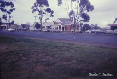
Photograph, High Street, Melton, 1969
View of High Street with the Police Station [House] and Court House in the background. Small house in McKenzie street on right in the distance. Land vacant prior to construction of Supermarket. Small house at the rear of Police Station. emergency services, local architecture -
 Bendigo Historical Society Inc.
Postcard - BLANCHE SLY POSTCARD COLLECTION, 1900 - 1920
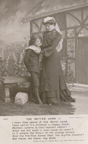
Postcard Album of Blanche Sly. Postcards stored in Folder 81 (49 postcards). 1403.1 - 1403.28 Grey linen look cover with picture of a small sailing boat pasted centre front pf cover. Partly torn sticker on lower LH corner. Blanche Victoria SLY Born: 11 Oct 1890, daughter of William and Hannah Sly Address: 1913; Loddon Vale Address: 1980; 100 Barnard Street Bendigo Died: Bendigo 12 June 1982, buried Bendigo G3 William Sly: Born: 1856 at Smythesdale, Victoria Married in Victoria in 1887; Hannah Theilman Died: Bendigo 1937, buried Bendigo G1 Hannah Sly Nee Theilman Born: 1866 Married in Victoria in 1887; William Sly Died: Bendigo 1948, buried Bendigo G3 See additional Research .Postcard Album of Blanche Sly containing 49 postcards. See 1403 B&W studio photo of a lady looking down at a youth Cottage and flowers as a backdrop. A poem 'The Better Land' beneath the photo.Addressee - Miss E Port (Staff), Convalescent Home, Woolton. Nr Liverpool Sender - Florrie Date stamp Jan 11, 1906postcard, collector, blanche sly -
 Bendigo Historical Society Inc.
Document - SANDHURST SCHOOL OF MINES COLLECTION: LETTER FROM COHEN , KIRBY & WOODWARD SOLICITORS
SANDHURST (BENDIGO) SCHOOL OF MINES LETTER from Cohen, Kirby & Woodward Solicitors to Registrar School of Mines Bendigo. Re Hayes and School of Miners, dated 17.6.1907, - dispute over a small area of landdocument, bendigo school of mines -
University of Melbourne, Burnley Campus Archives
Newspaper - Newspaper Cutting, The Age, University May Axe Regional Campuses, 01.10.2004
university of melbourne, regional campuses, faculty of land and food resources, memo, dean faculty of land and food resources, country campuses, closure of campuses -
Lakes Entrance Historical Society
Book, VEAC, Draft Paper on Historical Places Investigation, 2015
In March 2014 the minister of environment and climate change requested VEAC to undertake an investigation into historic places on public land in Victoria. This draft paper initiated a public consultation after which a final report in 2016.historic sites -
Lakes Entrance Historical Society
Book, Goding, Alison, This Bold Venture - The Story of Lake Tyers House, 1990
The story of Lake Tyers House, Gippsland, Victoria, built in 1886, and the early tourism industry. It is also describes early transport and land settlement, and touches on Aboriginal life before and after European. Index and bibliography.tourism, aboriginals, transport, waterways -
University of Melbourne, Burnley Campus Archives
Plan - Photocopy, County [of Bourke], c.1930
Given to Archives by Emma Ferguson and Jo van Berkel who used it in preparation of their 1994 thesis on the history of the Burnley Gardens. Photocopy of a plan depicting Burnley College as it was in the 1930's. It shows the Pavilion and surrounding gardens, coops and yards, various small outbuildings. Shows the contours of the land in the northern section of the property bordering Swan St. Some additions and comments have been added to original document, mainly to do with sewerage and water supplyburnley college, pavilion, emma ferguson, jo van berkel, orchard, water supply -
 Ringwood and District Historical Society
Map - Plan of Subdivision, Part of Crown Allotment 43, Parish of Ringwood, County of Mornington - (Circa 1950)
Copy of land title map in manilla folder showing layout and size of seven residential allotments (Lots 1 to 4 and 17 to 19) in Canterbury Road Heathmont, north-east of Bedford Road corner.Ronald G. Lee Licensed Surveyor, 195 Bridge Road, Richmond. Tel 42-6356. -
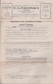
 Bendigo Historical Society Inc.
Document - H. A. & S. R. WILKINSON COLLECTION: CONTRACT OF SALE
Contract of sale of land dated 28th April, 1956 between Mr. L. F. Bright (vendor) and Mrs. E. Tyack (purchaser). Property: land having a frontage of 125 links to McKenzie street West by a depth of 392 links to Mistletoe Street being Crown allotment 10 section 578 Parish of Sandhurst City of Bendigo being land described in certificate of title volume 5975 folio 905 and situate corner McKenzie Street West and Mistletoe Street, Golden Square, together with weatherboard dwelling and all sundry outbuilding, also all inside and outside blinds, lino in backroom, all curtains, except those in the front bedroom and all electric light fittings and shades escept shade in lounge room. Price 1,100 pounds.organization, business, h.a. & s.r wilkinson real estate -
 Bendigo Historical Society Inc.
Document - H. A. & S. R. WILKINSON COLLECTION: CONTRACT OF SALE
Conditions of sale by private contract dated 9 July, 1946 between Mr. J. W. W. + Mr. H. S. P. + Ms. A. A. Challenger executors of estate of E. Challenger (vendor) and Mr. A. R. Thomson (purchaser). Property: land situate No. 70 Barkly Place, Bendigo at present occupied by Mr. C. Thomson as tenant, being part of Crown allotment 4 section 33C Parish of Sandhurst City of Bendigo, land described in certificate of title volume 4751 folio 950016 - Secondly land being part of Crown allotment 14 section 33C described in certificate of title 3547 folio 709284, together with 6 roomed brick and weatherboard dwelling, all sundry outbuildings except those belonging to the tenant. Subject to existing weekly tenancy. Price: 840 pounds.organization, business, h.a. & s.r wilkinson real estate -
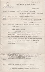
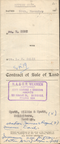 Bendigo Historical Society Inc.
Document - H.A. & S.R. WILKINSON COLLECTION: CONTRACT OF SALE
This business was owned by father and son, Henry Archibald Wilkinson and Samuel Ronald "Ron" Wilkinson. Henry (1882-1954) was born in Shepparton and died in Bendigo. He was married to Grace Hovendon in 1908. Samuel Ronald "Ron" (1914-1995), Henry's son, was married to Florence Jean McKerlie in 1937.Contract of sale of land dated 28th November, 1958 between Mrs. V. Hunt (seller) and Mrs. L.M. Salis (buyer). Solicitor for vendor: Messrs. Hyett, Willis & Hyett, Bull Street, Bendigo. Solicitor for purchaser: Messrs. Watson, James & Rogers, Bull Street, Bendigo. For so much and such parts as lie above the depth of fifty feet below the surface of land being lot 1 on the vendor plan of subdivision situate at the corner of Victoria and Prout Streets, Bendigo part of allotment 420A section K land being delineated and colored red, blue and brown on the map in the margin hereof, together with all buildings thereon and with all floor coverings, internal and external blinds, curtains and electric light fittings and shades. Price 2,000 pounds.organization, business, h.a. & s.r wilkinson real estate -
 Ballan Shire Historical Society
Map - Map. Moorarbool East and West, Country Lands in the Parishes of Moorarbool East and Moorarbool West. Counties of Bourke and Grant
This is a map of "Country Lands" around the Werribee River, north of Ballan in the Counties of Bourke and Grant.A relatively small map, paper on a material backing. Shows topographical features, roads and property divisions. Scale of forty chains to one inch. The map is dated March 31st, 1859.There is a small inscription under the chain scale that reads "No 58/364 John Phillips ? Survey 1st August 1858". The name Dugald McPherson is hand written on one of the blocks of land.moorarbool west, moorarbool east, dugald mcpherson, county of bourke, county of grant, werribee river, ballan -
![7 Roomed Brick [villa]; Modern Conveniences](/media/collectors/550653872162f11fb04854aa/items/59ec3da221ea690fdc4ba793/item-media/59ec3ee521ea690fdc4d0c37/item-fit-380x285.jpg) Kew Historical Society Inc
Kew Historical Society IncPhotograph - 7 Roomed Brick [villa]; Modern Conveniences, 1920s
The Kew Historical Society's map collection includes a substantial number of real estate subdivision plans, mainly of Kew but also of surrounding suburbs in Melbourne. Most of the subdivision plans date from the 1920s and 1930s when the districts old homes and local farmland were being split up to accommodate residential growth in the postwar period. These early plans were assembled by a local firm, Jas R Mather & McMillan, which had an office in Cotham Road. Many of the plans, and sometimes photos, were annotated by the agents.Subdivision plans are historically important documents used as evidence for the growth of suburbs in Australia. They frequently provide information about when the land was sold as well as evidence relating to surveyors and real estate and financial agents. The numerous subdivision plans in the Kew Historical Society's collection represent working documents, ranging from the initial sketches made in planning a subdivision to printed plans on which auctioneers or agents listed the prices for which individual lots were sold. In a number of cases, the reverse of a subdivision plan in the collection includes a photograph of a house that was also for sale by the agent. These photographs provide significant heritage information relating house design and decoration, fencing and household gardens.The photograph may also be aesthetically significant depending on the importance of the photographic atelier.A professionally produced photograph for a local real estate agent, probably Jas. R. Mathers, Son & McMillan. The photograph is of a Federation-era bungalow, in Kew. The photo is on the reverse of a subdivision plan for the Normanby Heights Estate, Kew.The mount on which the photograph is placed includes: "Kew. 1 minute to tram. Good Position. / 7 roomed brick. Modern conveniences. / Land 60 x 135. 1100 pounds"real estate photographs, houses - kew, federation architecture -
 Ringwood and District Historical Society
Photograph, Original Ringwood Police Station built 1988. c1970's
Black and white photograph of brick building.Written on rear of backing sheet: "Old Police Station 1888, 32 Mt. Dandenong Rd. Used as private residence. Sold for $20.000. Originally cost £20 (land only)." -
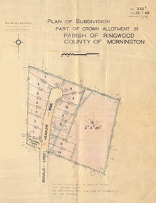 Ringwood and District Historical Society
Map - Plan of Subdivision, Part of Crown Allotment 39, Parish of Ringwood, County of Mornington - 1968
Map showing residential allotments numbered 1 to 14 Headline Court, Heathmont, Victoria, off Bronaldi Street and Yallamba Place. Adjoining lot 15 marked as 2 acres 3 roods 29.8 perches with house and garage.Paul Millar & Associates, Land & Engineering Surveyors, First Floor, 14A Main Street Croydon (Phone) 723 4493. Ref. 232B Date 23.1.68 Amended 12.3.68 & 1.12.71. -
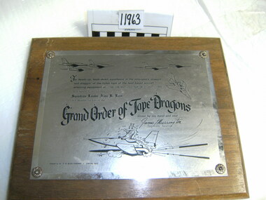 National Vietnam Veterans Museum (NVVM)
Plaque, Grand Order Of Tape Dragons
Silver plaque mounted on solid wood depicting seven fighter jets, five at top, one flying downwards with a dragon in the cockpit, one at bottom with a full length dragon atop of fighter jet. Sgn Ld Alan r Reed is a Life member of the Grand Order Of tap DragonsFor head-sup, hook-down excellence in the emergency snaggin' and draggin' of the nylon tape of the land-based aircraft arresting equipment at Tan Son Nhut, Vietnam on 21st Sept 1968plaque, alan reed, tan son nhut -
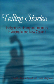 Victorian Aboriginal Corporation for Languages
Book, Fiona Magowan, Telling stories : Indigenous history and memory in Australia and New Zealand, 2001
Telling Stories looks at the place of life stories and of memory in history: who tells life stories: the purpose for which they are told: the role of story and history in the politics of land claims: and the way language impacts on research and writing. Contents: Introduction /? Bain Attwood and Fiona Magowan 1. Indigenous Australian life writing: tactics and transformations /? Penny van Toorn 2. Stories for land: oral narratives in the Maori Land Court /? Ann Parsonson 3. Crying to remember: reproducing personhood and community /? Fiona Magowan 4. The saga of Captain Cook: remembrance and morality /? Deborah Bird Rose 5. Encounters across time: the makings of an unanticipated trilogy /? Judith Binney 6. In the absence of vita as genre: the making of the Roy Kelly story /? Basil Sansom 7. Autobiography and testimonial discourse in Myles Lalor's 'oral history' /? Jeremy Beckett 8. Taha Maori in the DNZB: a Pakeha view /? W. H. Oliver 9. Maori land law and the Treaty claims process /? Andrew Erueti and Alan Ward 10. 'Learning about the truth': the stolen generations narrative /? Bain Attwood.B&w photographsindigenous history, maori history, oral histories -
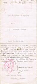
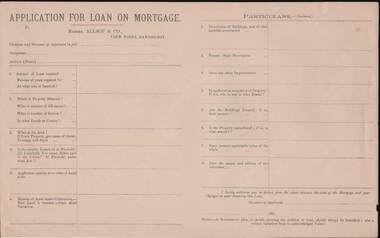 Bendigo Historical Society Inc.
Document - KELLY AND ALLSOP COLLECTION: APPLICATION FOR LOAN ON MORTGAGE
Application for Loan on Mortgage. Messrs Allsop & Co., View Point, Sandhurst. Application has space for name, occupation, amount of Loan, number of years, interest rate, Where, number of Allotment, Section, parish or County, Area, Leasehold or Freehold. Applicants opinion as to value of Land alone. Number of Acres under Cultivation. How Land is watered. State Shire Valuation, Description of Buildings and materials used, Fences, Improvements. Application for Loan on Mortgage. Messrs Allsop & Co., View Point, Sandhurst. Application has space for name, occupation, amount of Loan, number of years, interest rate. Where, number of Allotment, Section, parish or County, Area, Leasehold or Freehold. Applicants opinion as to value of Land alone. Number of Acres under Cultivation. How Land is watered, State Shire Valuation, Description of Buildings and materials used, Fences, Improvements. Is applicant in occupation of Property, if not who is, and at what Rental. Are Buildings Insured, if so, what amount. Is the Property encumbered, is so, to what amount. Present marketable value of the whole, and names and addresses of two references. Authorization to deduct from the advance the costs of the Mortgage and Charges on obtaining the Loan. Note at the end - A Government plan, or sketch showing the position of the land and written valuation from an acknowledged Valuer. On the back is space for a Valuator's Report and a note to the Valuators, also a Proposal for Loan on Mortgage with details of the loan. Date on the form is 188-.business, stockbroker, kelly & allsop, kelly and allsop collection - application for loan on mortgage, allsop & co. -
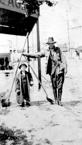 Surrey Hills Historical Society Collection
Photograph, Fred Lyons and his son Arthur after a hail storm, 1924, 1924
Lyons family history: Frederick Adolphus (Fred) Lyons operated a cab / taxi service in Union Road for several decades. Arthur was the only son of Frederick Adolphus Lyons (1891-1980) who was born in Surrey Hills, son of Thomas and Catherine Lyons. He married Elizabeth Ruby Hall in 1918. They lived at 55 Sunbury Crescent. The Lyons’ home was called ‘Knopshambury’ - this was probably a misspelling of Knockshanbally in Co Kilkenny, the birth place of Fred’s father, Thomas Edmund Josias Lyons (1846-1915).Arthur Lyons was born in Surrey Hills on 12 Jun 1920. He became a motor mechanic / welder and lived his whole life at 55 Sunbury Crescent. This is one of a series of photos donated by Arthur Lyons. The donation was made while he was in hospital. He died shortly afterwards (23 Sep 1990). Donation was finalised by a neighbour, Mrs Florence Ann Armitstead, wife of Glen Victor Armitstead. Glen was a local hairdresser. They moved to 11 Sunbury Crescent after their marriage in 1939. Arthur had no relatives to distribute the material to. The hail storm occurred on 2 December 1924.Despite the poor condition, this is significant because of the clear detail of the Union Road buildings and railway crossing in the background in 1924.Black and white photo of cab driver Fred Lyons with his son Arthur taken at the cab rank near the Surrey Hills station, clearing up after a hail storm in 1924. Fred balances 2 large shovels; Arthur has an over-sized jacket on. The railway gates and overhead lines can be clearly seen in the background. Despite the poor condition, it is a relatively significant photo as it details Union Road buildings and the railway crossing clearly behind it.On back of photo is written in pencil "copied 1996" and in blue pen "2/12/24"railway crossings, hail storms, frederick adolphus lyons, fred lyons, arthur frederick lyons, arthur lyons -
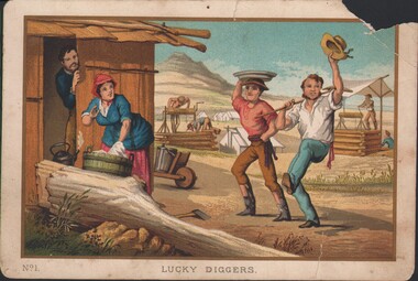 Bendigo Historical Society Inc.
Postcard - WES HARRY COLLECTION: LUCKY DIGGERS
From a set of ten plates, the plates are: 1. Lucky diggers -- 2. Clearing the forest -- 3. Spearing emus -- 4. The stockrider -- 5. The vineyard -- 6. A pannikin of gold -- 7. Throwing the boomerang -- 8. Opossum hunting -- 9. Washing tailings -- 10. Teamsters' rest. The prints are numbered 1-10 and individually titled. Also available online http://nla.gov.au/nla.obj-139535117 U1526-U1535.A colour or coloured print of some lucky diggers dancing in the street with some smiling onlookers. In the background there are some tents and two windlasses. On the bottom left of the card is printed No. 1, indicating that this is one of a series. postcard, mine site, diggers, mining camp -
 Ringwood and District Historical Society
Flyer, Executor's Auction Subdivision Advertisement, Lilydale Road and Oban Road, Ringwood East, Vic. - 1937
Single page advertisement for Executor's Auction of land in Ringwood East on Saturday, May 29, 1937 with locality map showing 26 building sites for auction highlighted in brown, and brief summary of local services available. Subdivision includes Old Lilydale Road, Joseph Street, Dynes Street, Albert Street (later Wyrunga Street), Carcoola Road, and Mount Dandeong Road. (Carcoola Road incorrectly shown as Oban Road on the subdivision plan). Auctioneer - C.E. Carter, (Phone Ringwood 24. -
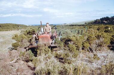 Phillip Island and District Historical Society Inc.
Photographs/Slides, Laurie Dixon, 1961
Five of a collection of slides donated by Laurie Dixon. Water was pumped from Candowie Reservoir to nearby Almurta Basin and gravity fed to Wimbledon Heights Storage Basin. These open water basins were two main components of the water distribution of the day and supplied the area from 1964 to 1989. The Almurta and Wimbledon Heights Storage Basins were decommissioned in 1999 when the San Remo Basin was improved an now is the vital link in the transfer of water from Candowie via the Purification Plant.Five of a collection of slides taken by Laurie Dixon. (Photographs scanned by E Alexander). The photographs are of the machinery used to clear the land for the reservoir constructed at Wimbledon Heights in September 1961 273-08 Robert Cleeland on TractorInscriptions of slides 273-09. Tourerpull & crawler at reservoir Sep. 61 273-10. Reservoir Sep 61 273-11. Reservoir Sep 61 273-12. Building reservoir Sep 61wimbledon heights reservoir, laurie dixon -
Glenelg Shire Council Cultural Collection
Postcard - Postcard - Flooding in Casterton, n.d
SOURCED FROM CASTERTON TOWN HALL (FORMER SHIRE OF GLENELG) Sourced From Casterton Town Hall (Former Shire of Glenelg)Black and white photo postcard. 1946 flood. Water halfway up tin fence, man standing on railing, tractor towing horse float, flooded shed, trees part submerged, no dry land visibleBack: Purple stamp - 'POSTCARD' Purple photographer's stamp