Showing 4875 items matching "plantings"
-
 Wangaratta RSL Sub Branch
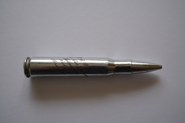
Souvenir - Cartridges, St Louis Ordnance Plant, 1942
The headstamp on these cartridges indicates they were manufactured in 1942 at the St Louis Ordnance Plant in Missouri USA. They were souvenired and engraved by Australian servicemen in New Guinea during WW2. All five cartridges are engraved with RAAF and Dutch New Guinea with one having additional engraving of Hollandia, Nadzab and Merauke. They belonged to 285492 Maurice Gerard HENDERSON born 21/9/1899 who enlisted at the age of 40 and served with the RAAF during WW2. He was deployed on 26/5/1944 with 113 FCU to Merauke in New Guinea.No. 13 Fighter Sector Headquarters was formed at Garbutt airfield on 16 Apr 1943. They embarked from Cairns, Queensland on 27 Jun 1943 and disembarked at Merauke on 2 Jul 1943. The Unit was renamed as No.113 Fighter Control Unit (113 FCU) on 7 Mar 1944. They moved to Townsville on 25 Feb 1945. The Unit was finally disbanded on 22 Apr 1945.Five white metal cartridges with round base tampered to a pointed top.Headstamp - SL 42 Engraved - RAAF Dutch New Guinea raaf, ww2, cartridge sl42, new guinea -
 Robin Boyd Foundation
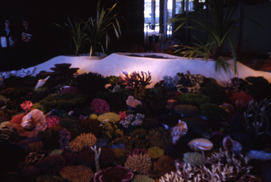
Slide, Robin Boyd, 1967
Robin Boyd was appointed Exhibits Architect for the Australian Pavilion at Expo ‘67 in Montreal. The garden outside the pavilion featured a sculptural pool, a coral display, animal pool, a pit for kangaroos and Eucalypts and other native plants. The indoor exhibits covered aspects of Australian art and culture, architecture, industrial design and scientific innovation, such as the Snowy Mountains Hydro-Electric Power Scheme, the Parkes radio telescope, the design of Canberra, and the Australian way of life. The coral display was prepared by E Grant, a fisheries research biologist.Colour slide in a mount. Coral display depicting the Great Barrier Reef, Australian Pavilion, Montreal Expo '67, Canada. Made in Australia / 17 / MAY 67M6 / 6 (Handwritten with red pen) / 10 (Handwritten)expo 67, montreal, robin boyd, slide -
 Mt Dandenong & District Historical Society Inc.
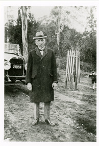
Photograph, Billy Hughes at Sassafras
Copy of a photograph of Mr W M (Billy) Hughes, the Australian Prime Minister from 1915 to 1923 in the Main Street of Sassafras. Billy Hughes had a holiday house called Ty-Coed in Clarkmont Road. The Prince of Wales made an unofficial visit in 1920 and stayed with Billy Hughes in his holiday home. The Prince of Wales planted a tree in Anzac Avenue that had been officially opened on April 14th, 1920 by Captain Stanley Melbourne Bruce, who became Prime Minister after Billy Hughes.Black and white photograph showing well dressed man standing in front of a car .billy hughes, w m hughes, sassafras, prime minister -
 Mt Dandenong & District Historical Society Inc.
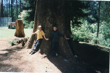
Photograph, Mount Dandenong Primary School 1997, 1997
The first Mt Dandenong State School opened in a shed on the property of William Ferguson on the corner of Blythe and Old Coach Roads. The first teacher was Miss Ethel Gruber who opened the school on May 11th, 1897. It wasn’t until 1901 that the school shifted over the road into an old school building that was moved up to the new site from Ringwood. All the old buildings were demolished to make way for a new school that opened in 1991. There are many old, European trees that were planted in the grounds during Arbor Days. Students standing at base of large Sequoia Tree in grounds of school in 1997, centenary year.mount dandenong, mt dandenong school, sequoia, centenary, trees -
 Friends of Westgarthtown
Painting, John Borrack, Ziebells, German Lane, South View
Painted from Gardenia Road. The extensive farm complex on the right. (Western side of Gardenia Road). was demolished in 1972 for housing development. Buildings shown are cowshed, hay barn, engine shed and stables. Painted in the late afternoon, the lengthening shadows and lowering sky, could presage the ominous fate awaiting the farm with development. The Ziebell Farm was known as “The Pines†and sadly none of the many that proliferated there remain. Today they would be equivalent to those at the cemetery, having been planted at the same time. Provenance: John Borrack CollectionWatercolour depicting Ziebell Farmhouse from the north, Thomastown and Mernda. In gold frame with cream border.Artist signature: John Borrack; 70's Ziebells German Lane South Viewillustrations, watercolours, john borrack, ziebell, watercolour, painting -
 Vision Australia
Text, Association for the Blind George Vowell Branch Committee meeting minutes 8/2/1989-11/10/2000, 1989-2000
Minutes of the Mt Eliza branch committee (later known as the George Vowell branch committee) including centre activities, staffing changes, fund raising appointment and resignation of committee members and life governorships. Some highlights include: 9/5/1990 - the success of the 10th Anniversary Ball, which was greatly enjoyed. 10/3/1993 - a demonstration of the new Dial-in News Service that operated from Kooyong. 14/4/1999 - A time capsule was being prepared to be 'planted' in the courtyard during Volunteers Week.1 bookassociation for the blind -
 Vision Australia
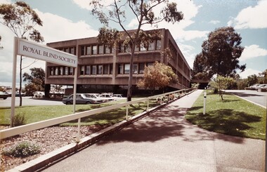
Photograph - Image, Royal Blind Society of New South Wales in Enfield
Colour photograph taken of the Royal Blind Society of New South Wales building in Enfield, as viewed from Mitchell Street. The two storey building has a car park underneath, with a separate external car park in the front of the building and a sloping driveway and footpath up to the covered entrance. To the right of the driveway is a short term visitors park. Gum trees are planted amongst a well kept lawn. Image was taken around the later 1970s-mid 1980s. A "Royal Blind Society' sign points up the driveway.Digital Image of Enfield building taken from Mitchell Streetroyal blind society of new south wales, buildings -
 Harcourt Valley Heritage & Tourist Centre
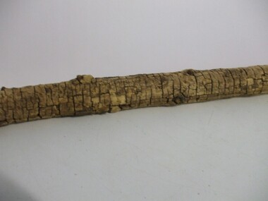
Mulberry Tree Branch, 1874
An unsuccessful attempt was made to set up a silkworm industry at Mt Alexander, to be an occupation for ladies of the district as well as to introduce the silk industry to Victoria. An attempt by women to enter the business world was beaten by difficulties: (1). Road access to the property (2). Heavy frost damage to mulberry plants. (3). Disease of silkworms. (4). Lack of quantity of leaves. (5) drought and rabbits. Experiments proved silk harvested and woven was superior to overseas products, but the venture was defeated by the climate and the surviving trees were relocated to Corowa NSWA relic of the far-sighted venture by the Victorian Ladies Sericulture Co, promoted by the charismatic Mrs Bladen Neill , who was anxious to generate employment opportunities for women..A dead branch from a mulberry tree grown at Sericulture Farm, Mt Alexander, in the early 1870s. This long limb's bark has cracked with age, forming a pattern of brown cracks. Remnants of smaller branch axilla are clearly visible. An inscription on paper is pasted around the branchTyped: "Part of a limb of a mulberry tree from the Sericulture Farm on Mt Alexander which was started by Mrs Bladen-Neill in early 1870s, finally closing in 1878. Mrs Bladen-Neill died in September 1884 at the residence of Dr Barker, Melbourne" "Courtesy of Keith Henderson, Harcourt" -
 Wodonga & District Historical Society Inc
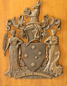
Sign - 2 Victorian State Shields from the Wodonga Court house
The Royal Warrant assigning the Armorial Bearings to Victoria was signed on the 6th June, 1910 by King George V. The motto Peace and Prosperity was the first to be in English among the Arms of any Public Authority in Australia. In 1958 the Pink Heath was proclaimed as the floral emblem of Victoria. This led to a request to have it included somewhere in the Armorial Ensigns of the State. The solution was to have the plant shown growing from a grassy mound. On the 28 March 1973 Queen Elizabeth II signed a further Royal Warrant which added the mound. This shield is the official emblem of the State of Victoria. It can only be displayed in limited place such as Law Courts and Victorian Government offices with permission of the Victorian Government.2 Victorian Coat of Arms from the Victorian State Government offices in Wodonga. The kangaroo at the top holds a crown. The shield also features the Southern Cross. Two female figures represent Peace and Prosperity. The figure on the left wears a laurel wreath crown and carries a sprig of olive in her hand, representing Peace. The other figure wears a crown of golden cereal and holds the horn of cornucopia, representing abundance or Prosperity. The first one is mounted on a wooden, varnished board.At the bottom of each shield "'PEACE AND PROSPERITY"shield, heraldry, victorian state government -
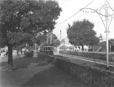 Melbourne Tram Museum
Photograph - W2 399 Victoria Parade, Sutcliffe Pty Ltd, c1930
Black and white photograph of W2 399 eastbound in Victoria Parade with the destination of Deepdene. The tram was fitted with route number boxes in 4/1930. The Victoria Parade line was opened to electric trams on 15/9/1929, dating the photo c1930. The photos shows established hedgerows that were planted along the tram track. The tram is at the Lansdowne St stop which has a tram stop shelter. Note the ornate scroll work on the centre poles. Iin the far distance can be seen the chimney of the Victoria Brewery,Yields information about the then new Victoria Parade tramway and tram 399.Black and white print with photographers stamp on the rear.Sutcliffe Photographers stamp.tramways, tramcars, w2 class, victoria parade, deepdene, centre poles, shelters, tram 399, mmtb -
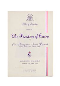 City of Greater Bendigo - Civic Collection
Ceremonial object - Invitation, City of Bendigo, The Freedom of Entry, 1970
On the 27th March, 1942 'Fortuna House' was occupied by LHQ Cartographic Company, Australian Survey Corps. Fortuna was the site of the base map plant and during this time approximately sixteen million maps of Australian Territories in the South West Pacific area were produced for use by the Allied Services. Fortuna was purchased in 1951 by the Commonwealth Government and until 1970 the Survey Corps and Regiment became part of community life in the district. This event to grant the Regiment Freedom of Entry took place at the Queen Elizabeth Oval on Sunday 14th June, 1970.Booklet outlining the celebrations commemorating the Army Survey Regiment's time in Bendigo. Includes a short history of the Regiment's association with the City which spanned from 1942 - 1970 as well as the day proceedings attended by the Mayor and Councillors.fortuna house, george lansell, royal aust survey corps, queen elizabeth oval, mayor jeffrey -
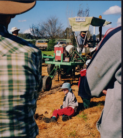 Wooragee Landcare Group
Photograph, 27 August 2004
This photograph was taken on Friday the 27th of August 2004 as part of an event called 'Direct Seeding Expo'. This event was one of many held by the Wooragee Landcare Group in the early 2000s which aimed to educate the local community on certain agricultural and biodiversity conservative techniques. This particular event took place at the property of Lisa and Marcus O'Connor in Wooragee. This photograph shows a demonstration being given on a Hamilton Tree Seeder (a soil ripper). This machine is used to loosen tough, compact soil in order to prepare it for the planting of seedlings.This photograph is significant as it provides evidence of a project undertaken by the Wooragee Landcare Group in the early 2000s to educate members of the public on alternative and potentially more efficient methods of planting seedlings. The Wooragee Landcare Group has been instrumental in the co-ordination of programs relating to biodiversity protection in the local area, providing great assistance to landholders.Portrait coloured photograph printed on gloss paperReverse: WAN NA EONA2N2. ANN+ 2 4240 / wooragee, wooragee landcare group, marcus and lisa o'connor, direct seeding expo, direct seeding, seeding, seedlings, soil ripper, soil ripping, ripper, hamilton tree seeder, alternative planting, seeding methods -
 Bendigo Military Museum
Mixed media - SCRAPBOOK BENDIGO RSL, 1963 - 1974
This is the final 4 pages of the Scrap book Cat No 8225. Page 17. The article refers to Mrs Doreen Crawford having spent 12 years as Assistant Secretary at the Bendigo RSL Memorial Hall until 1967, on leaving this job she took on a Visiting Officers role with Legacy in McKenzie Street Bendigo where she be looking after and visiting approximately 200 War Widows in their own homes as well as Homes & Hospitals. Page 18 & 19. The two photos re building sites pertain to the construction of the War Widows Flats in Kangaroo Flat about 1971/72. Page 20a. The B & W photo shows the completed War Widows Flats in Kangaroo Flat in 1973. This was a project by the War Veterans Homes Trust and the Bendigo RSL. Page 20b. The article is re the newly installed Bendigo RSL President Jack Plant receiving a Life Membership in 1974 from Robert Temple immediate past President. The article goes on to outline Jack Plants RSL work with the RSL, he first joined the RSL in Chinkapook in 1944, Committee and President Raywood RSL 1956 - 1958. Refer Cat No 8129P for his Bendigo RSL involvement.Four pages from a Spiroflex sketch pad. Page 17. Article with a photo of a female as main item. Page 18. B & W photo of a building under construction. page 19. B & W photo of cleared ground with building beginnings. Page 20. one B & W photo showing several buildings in a row. Article with two persons re award of Life membership.On page 17 in blue pen, "Advertiser 11.9.76", page 18 in blue pen, "War Widows Flats at Kangaroo Flat"brsl, smirsl, scrap book -
 Eltham District Historical Society Inc
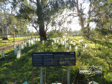
Photograph, Liz Pidgeon, Heritage Excursion; Eltham Lower Park Walk and Talk, 1 July 2017, 1 July 2017
Area planted with indigenous plants with information sign board Newsletter No., 234, June 2017 Heritage Excursion - Saturday 1st July - Eltham Lower Park - Walk and Talk Eltham Lower Park has played an important part in the history of our area since the early days of European settlement when it was used by local residents as an informal racecourse. Prior to that its location at the junction of the Diamond Creek and the Yarra River made it an important meeting place for the Wurundjeri people. The park combines formal elements and sporting facilities with remnant bushland that is of environmental significance. It is home to sporting and horse riding clubs, popular play spaces and the Diamond Valley Miniature Railway, which attracts large numbers of visitors. The park will be the venue for our July excursion which will comprise a walk of about 3.5 km around the park and adjacent areas. Along the way we will discuss the history and natural history of the area. The path along the creek and the river provides a pleasant and scenic walk. This walk on Saturday 1st July is about 3.5 km in length and will take 2 to 2.5 hours. It will start at 2pm at the Main Road car park at the front of the park. (Melway ref 21 H 10). Born Digitalheritage excursion, activities, eltham district historical society, eltham lower park, indigenous plants -
 National Wool Museum
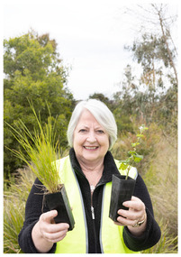
Photograph - Portrait of Rhonda Kelly, Nicole Marie, 2021
Thousands of volunteers work tirelessly to conserve and protect the environment of Geelong and the Bellarine. Their work often goes unnoticed. In 'The Work of Nature' the National Wool Museum and the Environment Department at the City of Greater Geelong worked with photographer Nicole Marie to showcase the significant contribution of environment volunteers in our region. Each of the eight people showcased in these portraits were nominated by their peers and members of the community for their significant contribution to conserving and protecting the environment. Rhonda Kelly - Friends of Waurn Ponds Creek Conservation volunteer projects not only have great biodiversity outcomes but are also collegial community groups that bring people together. Rhonda Kelly has worked tirelessly for over a decade for Waurn Ponds Creek. The Friends group is recognised throughout Geelong as a well-run, well organised and successful community group. This is due to the hard work of people like Rhonda. Rhonda is involved with all aspects of the Friends Group as Convener of the group, seed collector and propagator of plants at the community nursery. She is welcoming, passionate and hardworking. Not only does she organise the planting days and monthly clean-up days, but she also works with the community and schools engaging people with the value and beauty of the creek. Photo at Waurn Ponds Creek by Nicole Marie.Image showing an environmental portrait of a woman holding two potted seedlings with trees and grass in the background.environment, conservation, portraits, geelong, nature, exhibition, work of nature, geelong nature forum, volunteers -
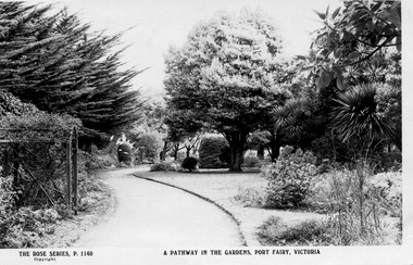
 Port Fairy Historical Society Museum and Archives
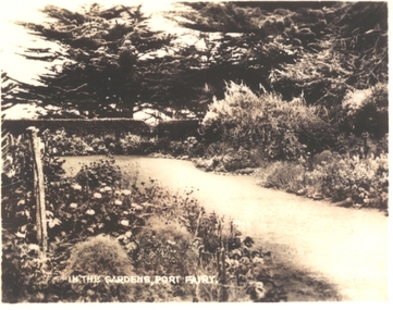
Postcard, In the Gardens, Port Fairy
The Port Fairy Botanical Gardens were formed in 1856 making it one of the earliest gardens in Victoria. The first curator was James Prior, he was paid fifty-two pounds per annum. He was an outstanding curator having been apprenticed to the trade in England at the age of 12, his brother Edward in later years was the Curator of the Koroit Gardens. Prior retired in 1903. During the years of his curatorship Port Fairy was said to have the best gardens outside the city of Melbourne, he was constantly in touch with Baron Von Mueller and later Guilfoyle of the Royal Botanical Gardens of Melbourne. In the early years plants from all over the world were planted here with varying rates of success many of them sent by Baron Von Mueller. In the 1930’ and 40’s the gardens were still very beautiful, and the curator was Roy Manuell. The beautiful iron gates at the entrance were destroyed in the 1946 floods and were replaced in 1989 using some of the material from the original gates. From the 1950’s on the gardens went into a state of decline, much being taken up by the caravan park until in 1986, after a public meeting ‘Friends of the Gardens’ was founded when the entrance section was restored. Black and white photograph of a path through the Botanical GardensIn the Gardens Port Fairygardens, botanical, path, griffith street, trees -
 Port Fairy Historical Society Museum and Archives
Photograph
Gardens in winter. The Port Fairy Botanical Gardens were formed in 1856 making it one of the earliest gardens in Victoria. The first curator was James Prior, he was paid fifty-two pounds per annum. He was an outstanding curator having been apprenticed to the trade in England at the age of 12, his brother Edward in later years was the Curator of the Koroit Gardens. Prior retired in 1903. During the years of his curatorship Port Fairy was said to have the best gardens outside the city of Melbourne, he was constantly in touch with Baron Von Mueller and later Guilfoyle of the Royal Botanical Gardens of Melbourne. In the early years plants from all over the world were planted here with varying rates of success many of them sent by Baron Von Mueller. In the 1930’ and 40’s the gardens were still very beautiful, and the curator was Roy Manuell. The beautiful iron gates at the entrance were destroyed in the 1946 floods and were replaced in 1989 using some of the material from the original gates. From the 1950’s on the gardens went into a state of decline, much being taken up by the caravan park until in 1986, after a public meeting ‘Friends of the Gardens’ was founded when the entrance section was restored. Bare trees In theBotanical Gardensgardens, botanical, griffith street, winter, autumn -
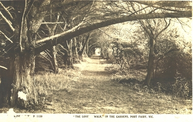 Port Fairy Historical Society Museum and Archives
Postcard - Post Card, The Rose Series / The Rose Stereographs, The Lovers Walk in the Gardens, Port Fairy
The Port Fairy Botanical Gardens were formed in 1856 making it one of the earliest gardens in Victoria. The first curator was James Prior, he was paid fifty-two pounds per annum. He was an outstanding curator having been apprenticed to the trade in England at the age of 12, his brother Edward in later years was the Curator of the Koroit Gardens. Prior retired in 1903. During the years of his curatorship Port Fairy was said to have the best gardens outside the city of Melbourne, he was constantly in touch with Baron Von Mueller and later Guilfoyle of the Royal Botanical Gardens of Melbourne. In the early years plants from all over the world were planted here with varying rates of success many of them sent by Baron Von Mueller. In the 1930’ and 40’s the gardens were still very beautiful, and the curator was Roy Manuell. The beautiful iron gates at the entrance were destroyed in the 1946 floods and were replaced in 1989 using some of the material from the original gates. From the 1950’s on the gardens went into a state of decline, much being taken up by the caravan park until in 1986, after a public meeting ‘Friends of the Gardens’ was founded when the entrance section was restored. Black and white Photograph of the path running along the river side of the gardens with trees overhanging the walkThe Rose Series P 1139 The Lovers Walk in the Gardens, Port Fairy, Vic.lovers walk - gardens, path, botanical, trees -
 Port Fairy Historical Society Museum and Archives
Postcard, The Rose Series / The Rose Stereographs, Entrance to the Gardens Port Fairy Victoria, 1926
The Port Fairy Botanical Gardens were formed in 1856 making it one of the earliest gardens in Victoria. The first curator was James Prior, he was paid fifty-two pounds per annum. He was an outstanding curator having been apprenticed to the trade in England at the age of 12, his brother Edward in later years was the Curator of the Koroit Gardens. Prior retired in 1903. During the years of his curatorship Port Fairy was said to have the best gardens outside the city of Melbourne, he was constantly in touch with Baron Von Mueller and later Guilfoyle of the Royal Botanical Gardens of Melbourne. In the early years plants from all over the world were planted here with varying rates of success many of them sent by Baron Von Mueller. In the 1930’ and 40’s the gardens were still very beautiful, and the curator was Roy Manuell. The beautiful iron gates at the entrance were destroyed in the 1946 floods and were replaced in 1989 using some of the material from the original gates. From the 1950’s on the gardens went into a state of decline, much being taken up by the caravan park until in 1986, after a public meeting ‘Friends of the Gardens’ was founded when the entrance section was restored. Black and white Photograph of the main path through the botanical Gardens with the arbour to the left and mature trees and lawn on the rightEntrance to the Gardens Port Fairy Victoriagardens - entrance, path, arbour, trees, griffith street -
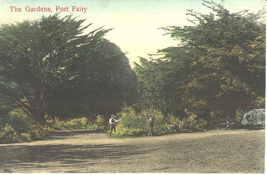 Port Fairy Historical Society Museum and Archives
Postcard - Post Card, The Gardens, Port Fairy
The Port Fairy Botanical Gardens were formed in 1856 making it one of the earliest gardens in Victoria. The first curator was James Prior, he was paid fifty-two pounds per annum. He was an outstanding curator having been apprenticed to the trade in England at the age of 12, his brother Edward in later years was the Curator of the Koroit Gardens. Prior retired in 1903. During the years of his curatorship Port Fairy was said to have the best gardens outside the city of Melbourne, he was constantly in touch with Baron Von Mueller and later Guilfoyle of the Royal Botanical Gardens of Melbourne. In the early years plants from all over the world were planted here with varying rates of success many of them sent by Baron Von Mueller. In the 1930’ and 40’s the gardens were still very beautiful, and the curator was Roy Manuell. The beautiful iron gates at the entrance were destroyed in the 1946 floods and were replaced in 1989 using some of the material from the original gates. From the 1950’s on the gardens went into a state of decline, much being taken up by the caravan park until in 1986, after a public meeting ‘Friends of the Gardens’ was founded when the entrance section was restored. hand tinted photograph of two men working in the Botanical Gardens at the fork in the pathThe Gardens, Port Fairygardens, botanical, gardener -
 Port Fairy Historical Society Museum and Archives
Postcard - Post Card, Wm Thompson, Gardens, Port Fairy
The Port Fairy Botanical Gardens were formed in 1856 making it one of the earliest gardens in Victoria. The first curator was James Prior, he was paid fifty-two pounds per annum. He was an outstanding curator having been apprenticed to the trade in England at the age of 12, his brother Edward in later years was the Curator of the Koroit Gardens. Prior retired in 1903. During the years of his curatorship Port Fairy was said to have the best gardens outside the city of Melbourne, he was constantly in touch with Baron Von Mueller and later Guilfoyle of the Royal Botanical Gardens of Melbourne. In the early years plants from all over the world were planted here with varying rates of success many of them sent by Baron Von Mueller. In the 1930’ and 40’s the gardens were still very beautiful, and the curator was Roy Manuell. The beautiful iron gates at the entrance were destroyed in the 1946 floods and were replaced in 1989 using some of the material from the original gates. From the 1950’s on the gardens went into a state of decline, much being taken up by the caravan park until in 1986, after a public meeting ‘Friends of the Gardens’ was founded when the entrance section was restored. PhotographThe Gardens, Port Fairygardens, botanical -
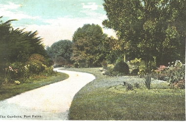
 Port Fairy Historical Society Museum and Archives
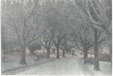
Postcard, Botanical Gardens, c.1930
circa 1930. The Port Fairy Botanical Gardens were formed in 1856 making it one of the earliest gardens in Victoria. The first curator was James Prior, he was paid fifty-two pounds per annum. He was an outstanding curator having been apprenticed to the trade in England at the age of 12, his brother Edward in later years was the Curator of the Koroit Gardens. Prior retired in 1903. During the years of his curatorship Port Fairy was said to have the best gardens outside the city of Melbourne, he was constantly in touch with Baron Von Mueller and later Guilfoyle of the Royal Botanical Gardens of Melbourne. In the early years plants from all over the world were planted here with varying rates of success many of them sent by Baron Von Mueller. In the 1930’ and 40’s the gardens were still very beautiful, and the curator was Roy Manuell. The beautiful iron gates at the entrance were destroyed in the 1946 floods and were replaced in 1989 using some of the material from the original gates. From the 1950’s on the gardens went into a state of decline, much being taken up by the caravan park until in 1986, after a public meeting ‘Friends of the Gardens’ was founded when the entrance section was restored. Black and white Photograph of the botanical gardensIn The Gardens Port Fairybotanical, gardens, 1930, path, trees, hedge, griffith street -
 Port Fairy Historical Society Museum and Archives
Photograph
The Port Fairy Botanical Gardens were formed in 1856 making it one of the earliest gardens in Victoria. The first curator was James Prior, he was paid fifty-two pounds per annum. He was an outstanding curator having been apprenticed to the trade in England at the age of 12, his brother Edward in later years was the Curator of the Koroit Gardens. Prior retired in 1903. During the years of his curatorship Port Fairy was said to have the best gardens outside the city of Melbourne, he was constantly in touch with Baron Von Mueller and later Guilfoyle of the Royal Botanical Gardens of Melbourne. In the early years plants from all over the world were planted here with varying rates of success many of them sent by Baron Von Mueller. In the 1930’ and 40’s the gardens were still very beautiful, and the curator was Roy Manuell. The beautiful iron gates at the entrance were destroyed in the 1946 floods and were replaced in 1989 using some of the material from the original gates. From the 1950’s on the gardens went into a state of decline, much being taken up by the caravan park until in 1986, after a public meeting ‘Friends of the Gardens’ was founded when the entrance section was restored. Bless keep and white photograph of a circular flower gardengarden, flowers, paths, trees -
 Wodonga & District Historical Society Inc
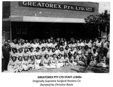
Photograph - Greatorex/ Supreme Surgical Hosiery Co. Wodonga
The Greatorex company came to Wodonga in August 1945 under the Cain Government decentralisation policy. It initially had premises in Beechworth Road, around the corner from Tallangatta Road (now Thomas Mitchell Drive). Due to expansion they later relocated to the corner of Tallangatta Road and Anne Street Wodonga in 1952. Greatorex had its main manufacturing plant in Melbourne, Victoria. At their peak Greatorex Pty Ltd. which also operated as Supreme Surgical Hosiery Co., manufactured brassieres, swimsuits, elastic thread, surgical hosiery and employed 90 staff in Wodonga. The company which was operated by Thomas Greatorex with Mr M. P. Brain as Manager, also owned Fulflex Yarns Pty. Ltd. Fulflex produced elastic yarns to be used in the manufacture of garments at Supreme Surgical Hosiery. In 1960, due to the increasing cost of freight charges for moving raw materials and manufactured goods to and from Melbourne, the company was forced to close down. Plant and machinery valued at over £30,000 was moved to Melbourne. Some personnel were given the opportunity to also transfer to the parent company. In 2024, the company still operates as Greatorex Textile Industries P/L in Moorabbin, Victoria.These images are significant because they document an industry which operated in Wodonga in the 1940s and 1950s.A collection of black and white photos of workers at the Greatorex / Supreme Surgical Hosiery Co. in Wodonga.Names listed beneath one of the images.greatorex industries, wodonga industries -
 Eltham District Historical Society Inc
Photograph - Digital Photograph, Marguerite Marshall, Hawthorn hedges, Eltham-Yarra Glen Road, Kangaroo Ground, 3 October 2006
Hawthorn hedges are important reminders of Kangaroo Ground's Scottish heritage. They are Registered on the Victorian Heritage Register. They are "historically significant because the planting of hawthorn hedges reflects the adoption of Eurorpean farming techniques by the Kangaroo Ground population in the period following settlement and because the grid pattern of paddocks that the Hawthorn hedges define is very different to today's farm landscapes." Covered under Heritage Overlay, Nillumbik Planning Scheme. Published: Nillumbik Now and Then / Marguerite Marshall 2008; photographs Alan King with Marguerite Marshall.; p21 Hawthorn hedges bordering Kangaroo Ground’s gently rolling farmlands are important reminders of its Scottish heritage and are rare so close to Melbourne.1 As early as the 1840s newly arrived farmers from Scotland planted hawthorn hedges around their properties, to protect crops from the numerous kangaroos and wallabies. Many of these hedges survive today. These farmers had the good fortune to settle some of the most fertile land available for cropping in the Colony of Victoria. At that time the black volcanic soil could sustain an amazing two crops a year. By the mid 1850s, 500 acres (202ha) of wheat were growing in Kangaroo Ground. But the crops were threatened by kangaroos, which were so plentiful, that Surveyor-General, Robert Hoddle, named the district Kangaroo Ground in 1838. As post-and-rail fences proved inadequate barriers for the bounding kangaroos, the Scots planted hawthorn hedgerows as they had done in Scotland. Some also used the hedges to net birds, presumably for the table. Interestingly the farmers in the bordering townships of Panton Hill and Christmas Hills, did not plant hawthorn hedges around their properties. Perhaps it was because by the time they settled in the 1860s and 1870s most of the wildlife had been gunned down by residents.2 The canny Scots planted the hedges on public land outside their own farms, as the hedgerows could spread to about five yards (five m) in width. With this impenetrable barrier Kangaroo Ground’s industrious farmers flourished to gain the economic power that saw the Shire of Eltham governed from Kangaroo Ground for 79 years (1858-1937). The Scots jealously guarded their land, so hard to get in Scotland. That is why they refused to release any of it ‘for local roads to follow easier grades as was the case in surrounding districts where roads generally followed ridgelines or streams’.3 Instead the roads were built in accordance with the magnetic bearings of their first survey in 1847 whether that suited the steep topography or not. This could force traffic to diverge when wet through Greensborough and Diamond Creek. Until 1921, the Eltham-Yarra Glen Road beside Wellers Restaurant, ‘dipped down into the upper reaches of Stony Creek’.4 Later some corners were compulsorily cut for the increasing motor traffic. As late as the 1960s, corners were cut to form sweeping curves above and alongside the Kangaroo Ground Cemetery and opposite the Emergency Operations Centre. In the latter case, the farmers – understanding their hedgerows as important heritage – insisted upon their reinstatement to conform to the altered road alignment. Kangaroo Ground’s ancient manna gums also point to the district’s history and to that of the hedgerows. The Aboriginal people had transformed the original forests into grasslands with the fires they lit to attract kangaroos, (which the Scots were to exclude by planting hedgerows). But the Wurundjeri hunters left the gums (Eucalyptus vimminalis cygnetensis), on the grasslands as ‘stalking trees’ to hunt kangaroos. The hawthorn hedges in Kangaroo Ground were neglected for around 60 years from about the middle of the 20th century. Bushfires had created gaps and the hedgerows were not trimmed. Then in late 2005, local historian Mick Woiwod, formed a group to lobby the Nillumbik Shire to restore the hedges, which could last for many centuries. Some hedges in parts of Britain date back to AD 800.5 Although the original Scottish farmers have gone, the hedges are a reminder of when they flourished in the district, which has changed little in 150 years.This collection of almost 130 photos about places and people within the Shire of Nillumbik, an urban and rural municipality in Melbourne's north, contributes to an understanding of the history of the Shire. Published in 2008 immediately prior to the Black Saturday bushfires of February 7, 2009, it documents sites that were impacted, and in some cases destroyed by the fires. It includes photographs taken especially for the publication, creating a unique time capsule representing the Shire in the early 21st century. It remains the most recent comprehenesive publication devoted to the Shire's history connecting local residents to the past. nillumbik now and then (marshall-king) collection, eltham-yarra glen road, hawthorn hedgerow, kangaroo ground -
 Eltham District Historical Society Inc
Photograph - Digital Photograph, Alan King, Diamond Creek, Barak Bushlands, Eltham, 2008
A habitat corridor and it strengthens the community. Published: Nillumbik Now and Then / Marguerite Marshall 2008; photographs Alan King with Marguerite Marshall.; p185 Barak Bushlands lie west of the Diamond Creek on the corner of Falkiner Street and busy, noisy Main Road. They form part of an important habitat corridor linking the Yarra River to the Kinglake National Park.1 Manna Gums, tawny frogmouths and platypuses are some of the indigenous plants and animals that have made their home there. The bushlands are the result of more than nine years of hard work by the local community with the Nillumbik Council, to transform a degraded flood plain into this refuge of natural beauty. In 1997, shortly after moving into the new Riverside Estate on Falkiner Street, Eltham, several residents noticed the sorry state of the Diamond Creek and surrounding area. Part of it was used as a cow paddock and although small patches of vegetation survived, the area was infested with weeds, rabbits, rubbish and drainage from the housing estate. At various times the 4.4 hectares had been used as a market garden and for shire stock piles. The residents began to restore the area by revegetating land along the Diamond Creek. In 1998 they established the Friends of the Diamond Creek Falkiner Street Reserve2 and 35 families joined from the 90-house Estate. Carolyn Mellor, as the Friends’ Land Manager, undertook a four-year horticulture course to guide this massive project for a volunteer organisation. Since 1999, she has been the Friends’ President. In 1999 the Friends urged the Nillumbik Council to undertake a feasibility study into establishing a wetland system and urban forest. Work began in 2002 with Nillumbik Council funding the project, supplemented by government grants. The Friends also received grants from Melbourne Water and Parks Victoria. Aided by the Friends and other community members, the Council created the Barak Bushlands consisting of a forest, a wetland, a bridge, a path and open space. The beautiful wetland treats most of the estate’s stormwater runoff. Storm water is filtered through plants in the wetland ponds then is released slowly into the billabong, before flowing into the Diamond Creek. The wetland also helps to minimise flooding and the improved water quality provides a flora and fauna habitat. The Friends and other volunteers planted more than 27,000 plants, more than one third of which they grew from seeds they collected at Lower Eltham and Wingrove Parks. Eltham High School students planted thousands of these through a Year Eight program introduced for this purpose. Other groups who assisted were: Green Corps, local Scouts and Guides – 2nd Montmorency, 1st Diamond Creek and 1st Eltham Cub Packs, Eltham College students, Eltham East Primary School, Landcare members, Eltham Lions Club and the Eltham Baptist Church. To maintain enthusiasm for the mammoth task, the Friends and other volunteers ‘adopted’ trees to water and wrote their names on the stakes. In 2004, to recognise the area’s original occupiers, the reserve was named Barak Bushlands. William Barak, who lived from 1824 to 1903, was the last chief of the Yarra Yarra tribe of the Wurundjeri-willam people. Traces of these original inhabitants remain in scar trees (bark sections removed to make a shield or canoe). That same year the Friends’ group was a finalist in the prestigious Federal Government, Banksia Environmental Awards. The Friends have also participated in Clean Up Australia, removing tonnes of rubbish and regularly testing the billabong, wetland and creek, for pollutants. For years the Friends, together with the Australian Platypus Conservancy, have tagged, measured and checked the health of platypuses from the Diamond and Mullum Mullum Creeks. With Latrobe University the Friends have conducted night walks to view owls, possums, bats and sugar gliders. Challenges for the council and the Friends continue with a large rabbit population, some vandalism, weed eradication and maintenance. However, thanks to this community effort, locals can now escape confined urban living on small blocks of land and enjoy the beauty of indigenous plants and animals. Working together has also strengthened the local community,This collection of almost 130 photos about places and people within the Shire of Nillumbik, an urban and rural municipality in Melbourne's north, contributes to an understanding of the history of the Shire. Published in 2008 immediately prior to the Black Saturday bushfires of February 7, 2009, it documents sites that were impacted, and in some cases destroyed by the fires. It includes photographs taken especially for the publication, creating a unique time capsule representing the Shire in the early 21st century. It remains the most recent comprehenesive publication devoted to the Shire's history connecting local residents to the past. nillumbik now and then (marshall-king) collection, barak bushlands, diamond creek (creek), eltham -
 Marysville & District Historical Society
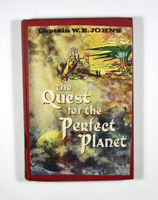
Book (item) - Hardcover book, Captain W.E. Jones, The Quest for the Perfect Planet-A story of Space Exploration, 1961
A novel by Captain W.E. Jones that was held in the Marysville State School library.A book from the Marysville State School library.Stamp of the STATE SCHOOL No. 1273/ UPPER/ 3/ FICTION/ MARYSVILLE In both front and back inside cover's labels have been removed leaving behind glue residue. Stamp of the Marysville & District Historical Society Inc/ P.O. Box 22/ Marysville 3779captain w.e. jones, planet, earth, space exploration, fiction -
Federation University Historical Collection
Book - Annual Report, Berry, Anderson & Co, Ballarat School of Mines Calendar Year 1901-02 with Annual Report and Balance Sheet for 1900, 1901
Calendar and Annual Report 1901-02, Associateship and Final Certificates, Calendar for 1902, Certificates issued during 1900 in Metallurgy of Gold and Ore Dressing, Discipline, Discipline Board, Fees, Full Certificates Issued, General Regulations, Honorary Correspondents, Meteorological Observations, Office Bearers, Passes Obtained since 1892 in Final Examinations, President's Annual Report, Professors and Lecturers, Results of Examinations Conducted by Education Department 1900, Statement of Receipts and Expenditure for Year 1900, Statistics - Students Attending Lectures, Subscriptions and Donations, Subjects Included in Regulations Technical Schools, Subjects of Instruction - Department of Chemistry and Metallurgy, Geological Department, Engineering Department, Electrical Department, Department of Mathematics and Physics, Practical, Plane and Solid Geometry, Photography, Time Table 1) 05225.1 Ballarat School of Mines Calendar for the Year 1901-02 with Annual Report and Balance Sheet for 1900, Pale grey soft cover, 93 Pages 2) 05225.2 Ballarat School of Mines Calendar for the Year 1901-02 with Annual Report and Balance Sheet for 1900, Pale grey soft cover, 93 Pages Images include: Senior Members of Staff, Interior of Museum, Balance Rooms, Engineering Lecture Room, Part of Cyanide Plant, Senior Chemistry Laboratory, Chemistry Lecture Room, Assay Laboratory, Junior Chemistry Laboratoryannual report 1901-02, andrew anderson - president, r. denham pinnock - vice president, hon. r.t. vale - vice president, the hon. john warrington rogers - trustee, the right reverend samuel thornton bishop of ballarat - trustee, james millhinch bickett - trustee, james oddie - trustee, the hon. henry cuthbert - honorary solicitor, r. g. middleton - honorary treasurer, thomas s. hart - curator of museum, chas. kent - auditor, fred j. martell - director, professor alfred mica smith, daniel walker, hubert r. murphy, charles a. deane, percy r. osborne, arthur garrad, thomas evans, douglas a. runting, ernest trend, thomas s. hart, g. stephen hart, professor g. j. dawbarn, a. e. c. kerr, herbert krause, henry j. hall, john m. sutherland, kerr grant, j. f. usher, chas, e. campbell, charles kent - auditor, chemistry laboratory, assay laboratory, electricity lecture room, charles kent, cyanide plant, judge warrington rogers, john warrington rogers, samuel thornton, james bickett, thomas hart, t.s. hart, henry hall, charles campbell, j.m. sutherland -
Federation University Historical Collection
Correspondence, Correspondence concerning the Burke Family, 1954, 20/05/1954
Some possibility the author is writing about Robert O'Hara Burke, but he was not married.Two letters typed .1) An air letter form J.L. Lonergan of Eastern Pensylvania addressed to Ballaratt University, and eventuallty delivered to the Ballarat School of Mines. The letter requests information on a Mrs Burke of Ballarat, whose husband was lost in the Bush. Mrs Burke ran a boading house. The author worked for Morris Machine Works and remembered a Chief Engineery from Ballarat visiting the plant at the beginning of World War One. .2) A letter on University of Melbourne letterhead redurecting the letter to Ballarat. The letter was signed by F.G. Elford for F.H. Johnston (Registrar)/j.l. lonergan, robert o'hara burke, mrs burke, kearney, f.g. elford, letterhead, f.h. johnston, morris machine works, air letter, aerograme -
 Bendigo Historical Society Inc.
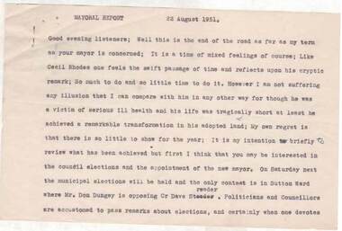
Document - NORMAN OLIVER COLLECTION: SPEECH NOTES 22 AUGUST 1951
The Norman Oliver collection. Norman Oliver was three times Mayor of Bendigo - 1950-51, 1964-65, 1970-71. Sixteen pages of typed notes headed Mayoral Report 22 August 1951. Corrections in blue ink. In the format he used for his talks on 3BO 'The Mayor Speaks'. The last report for his first Mayoral term. Topics include : the Year's work - land reclamation, the loan for earth moving plant, garbage disposal, sports grounds, drainage, Sewerage Authority, the saleyards, the Aerodrome, Housing, and the Bendigo Creek and town planning.bendigo, council, speech notes, norman joseph oliver , councillor norman oliver. mayor of bendigo. 3bo 'the mayor speaks'.