Showing 6380 items matching "system"
-
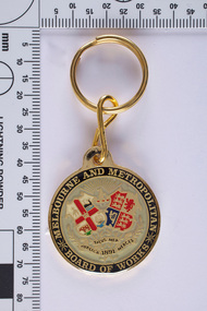 Melbourne WaterAs the Yarra became unsuitable as a source of water, several attempts were made to find alternative sources for the growing population of Melbourne. It was not until 1891 that the efforts to sewer Melbourne came to fruition with the setting up of the Melbourne Metropolitan Board of Works (MMBW), now known as Melbourne Water. From 1891 until 1992, it was the responsibility of the MMBW to safeguard public health by providing a sewerage system and a safe water supply system. In 1992, The MMBW merged with a number of smaller urban water authorities to form Melbourne Water. The seal incorporates the coat of arms of Melbourne and the United Kingdom, and the motto of the board 'Publica Merces Salus Mea', 'Public Health is my Reward'. Text around the circular edge and in banners below two shields. The banners have leaves entwined. Above the two shields there is a kangaroo in profile beneath sun rays. One shield is part of the Coat of Arms of Melbourne and has a hanging fleece (top left quadrant), whale (top right quadrant), a bull (lower left quadrant) and a three-masted ship (lower right quadrant). The other shield is part of the Coat of Arms of the United Kingdom and has three lions passant (top left and lower right quadrants) representing England, a lion rampant (top right quadrant) representing Scotland and a harp (lower left quadrant) representing Ireland. This MMBW key ring is of historical significance for its association with the former Melbourne and Metropolitan Board of Works (MMBW). The key ring is in a perfect condition and is significant as is represents a proud organisation and represents the organisations historical development of services, a strong theme of the collection. The key ring is aesthetically pleasing while the coat of arms holds great meaning. Gold key ring with the MMBW seal. mmbw, melbourne metropolitan board of works, souvenir, melbourne water, coat of arms, proud, seal, organisation
 -
 Bendigo Military Museum
Photograph - Aerotriangulation Production – Army Survey Regiment, Fortuna, Bendigo, c1970s to 1980s
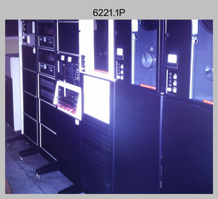
This collection of 14 photos was most likely taken in the 1970s and 1980s in Air Survey Squadron. The PDP 11/70 minicomputer shown in photo .1P was the operating system introduced in 1977 as the mainframe system for the control of the APC4, aerial triangulation block adjustments, SORA OP Analytical Orthophoto control, APR Analytical Terrain Profile Recorder computation, graphics, and general computing. Technicians used the Wild A9 Stereocomparator shown in photo .2P to accurately measure between pass, tie, and survey control points on aerial photographs. The Zeiss D2 Planimat Stereoplotter shown in photos .3P to .4P was used for analytical orthophoto control. It was introduced in 1972-1973 The Zeiss (Jena) Stecometer analytic stereocomparator for air photography shown in photos .5P to .11P and .14P was introduced at Air Survey Squadron in 1963. Aerotriangulation production was expedited using computers for analytical photogrammetric processes. The technician accurately measured between pass, tie, and survey control points on aerial photographs. Wild PUG4 point transfer devices shown in photos .12P to .13P were introduced in c1968 superseding the PUG2 devices. PUG4 devices were used by technicians to stereoscopically view the photography containing the survey control points and the mapping aerial photography. The Control points were transferred from the control photography to the mapping diapositives of aerial photography by drilling their locations into the photographic emulsion.This is a set of 14 photographs of Air Survey Squadron personnel operating aerotriangulation equipment at the Army Survey Regiment at Fortuna, Bendigo, c1970s to 1980s. Photographs .1P to .13P were on 35mm colour slide film and scanned at 96 dpi. Photograph.14P was printed on photographic paper and was scanned at 300 dpi. They are part of the Army Survey Regiment’s Collection. .1) - Photo, colour, c1979, PDP-11 minicomputer. .2) - Photo, colour, c1970s, Unidentified technician operating a Wild A9 Stereocomparator. .3) - Photo, colour, c1970s, Zeiss D2 Planimat Stereoplotter. .4) - Photo, colour, c1970s, Zeiss D2 Planimat Stereoplotter, unidentified technicians. .5) - Photo, colour, c1970s, Zeiss D2 Planimat Stereoplotter, SGT Christopher Wardley. .6) - Photo, colour, c1970s, Zeiss D2 Planimat Stereoplotter. .7) to.9) - Photo, colour, c1970, Zeiss (Jena) Stecometer, unidentified technicians. .10) to.11) - Photo, colour, c1988, SPR Toni Wright operating a Zeiss (Jena) Stecometer. .12) - Photo, colour, c1970s, Wild PUG4 point transfer device, SPR John Shepard. .13) - Photo, colour, c1970s, Wild PUG4 point transfer device, SPR David Edwards. .13) - Photo, colour, c1970s, Wild PUG4 point transfer device, SPR David Edwards. .14) - Photo, colour, c1980, Zeiss (Jena) Stecometer, SGT Bruce Hammond.Some of the equipment is annotated on the frame of the 35mm slides.royal australian survey corps, rasvy, army survey regiment, army svy regt, fortuna, asr, aerotrig, photogrammetry -
 Ballarat Tramway Museum
Ephemera - Ticket/s, State Electricity Commission of Victoria (SECV), Set of SEC predecimal tickets - Wal Jack Collection, 1960's
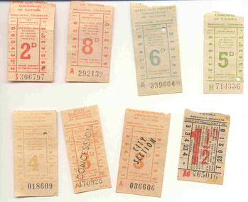
Yields information about the style and printing of tickets used in Ballarat tramways and how they were presented at the commencement of the SEC fare system. Generally issued c1963, some have dates on rear.Group of eight different pre-decimal values of used SEC Ballarat Tickets, ex the Wal Jack Collection. Tickets already held on the BTM system in blocks. All except .7, have a tartan or criss cross back. 1. - 5d Green (5 No. - B400836, B265927, W808385, B400835, Z742326) - note the same as Reg Items 3991 and 3994, though the printing of the section marks do vary a bit. These were not imaged. 2. - 5d Green (M714336) - imaged - has different section system on the side to the above - used 1/3/1963. 3. - 6d Teal - (34 No.) - some sequential - All A series. Note the same as Reg Item 3993. 4. - 6d Teal (L918047) - imaged 4009i4 - has different section system on the side to the above. 5. - 8d Red - (5 No. all A series, 292132 & 3, 206314, 315138 & 362937) - note the same as Reg Item 3984. 6. - 2d Red (S306797) - different section layout to Reg item 3986. 7. - 1 1/2d - (Ad705016) - black ticket, with red overprint of 1 1/2d fare and ticket prefix number - similar to Reg Item 2115, but different sectional layout. The section layout is the same as Reg Item 2116. Has Bushells Pty Ltd Tea advertisement on the rear. 8. - 3d City Section, Orange - (3No. A032622, 036606, 047637) - note the same as Reg Item 3982. All have dates on the rear - August 1963. 9. - 3d Concession - Orange, (A447731, 470928) - note the same as Reg Item 3989 and 4001. One has date of 1/3/63 on rear. 10 - 4d Brown (7 No. Y997727, 998446, Z004193, 005655, 012671, 018609 & 024899) - Some have dates of 1963 in pencil on the rear. Note the same as Reg Item 3995, though different series letter. All tickets and Reg Item 4006, 4007, 4010 to 4018 were received originally in a folded cloth wrapper - wax canvas? - with "All Since 1/3/1963 /3d Concession since 1/8/63" written in pencil on it. Stored with this item. See image btm4009i3. Tickets have not been formally numbered on the rear for this item No. All numbers recorded except for the 6d Teals. trams, tramways, secv, ticket -
 Melbourne Tram Museum
Pamphlet, Metlink, "Fares and Travel Guide", 2003 to 2008
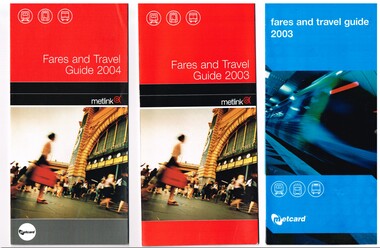
Set of nine "Fares and Travel Guide" for years 2003 (2 issues) to 2008. Each have contact details, and maps of the tram and train systems of Melbourne. Details fares, Metcard products, buying and validating Metcards, concession cards, refunds, travelling with pets, surfboards, general info. .1 - 2003 - Pamphlet - DL size, blue coloured covers six fold full colour printed on gloss paper, with details of operators - M>Train, Connex, M>Tram, Yarra trams - early 2003. .2 - 2003 - Pamphlet - DL size, red coloured covers six fold full colour printed on gloss paper, with details of operators - M>Train, Connex, M>Tram, Yarra trams - late 2003. .3 - 2004 - Pamphlet - DL size, red coloured covers six fold full colour printed on gloss paper, with details of operators - Yarra trams and Connex Trains. .4 - 2005 - Pamphlet - DL size, red coloured covers six fold full colour printed on gloss paper, with details of operators - Yarra trams and Connex Trains. Dated Jan. 2005. .5 - 2006 - Book - DL size, red coloured covers 20 pages, centre stapled, colour printed on gloss paper with fold out map, has index, ticket guides and other details about the Melbourne transport system. Dated Jan. 2006. .6 - 2007 - Book - DL size, red coloured covers 24 pages, centre stapled, colour printed on gloss paper with fold out map, has index, ticket guides and other details about the Melbourne transport system. Dated Jan. 2007. .7 - 2007 - June - as for .6 .8 - 2008 - January 2008 - as for .6, with D1 3510 and Flinders St station on front cover. (.7 added 16-11-2015 and .8 added 16-8-2017) .9 added - as for .5, but dated Feb. 2006. - added 8/7/2018. .10 - 2010 - 32 pages, red cover with an C2 class at Southern Cross station, etc - added 19/11/2020 See 2476.1 > 2476.4 for 2009 copy and another three languages. See 2328 for a 2011 copy. See 2393 for a 2013 copy. See 2507 for 2000 and 2001 copies.trams, tramways, tickets, fares, connex, m>tram, m>train, yarra trams, guides -
 Ballarat Tramway Museum
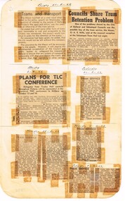
Newspaper, State Electricity Commission of Victoria (SEC) and The Courier Ballarat, Councils share tram retention problem, Sep. 1962
Yields information about the view of The Courier, and locals about the mooted closure of the tramway system.Foolscap sheet of plain paper, with rounded corners, with 8 newspaper cuttings, concerning the mooted closure of the Ballarat Tram system September. 1962. All from The Courier. 1 - "Trams and transport" - Editorial 2 - "Councils Share Tram Retention Problem" - discussions between the City and Sebastopol. Quotes Cr. Mills and Cr. Nicholson 3 - "Plans for TLC Conference" - discussions by Trades Hall in Mildura during Oct. 4 - Letter - Tram Battler - re pensioners and sermons 5 - Letter - Trammie - fare increases 6 - Letter - W. J. Parsons - re tram operations and church services 7 - Letter - Old Digger - Geelong services 8 - Letter - Retired teacher - safety and response to Old Digger. closure, letter to the editor, editorial, sec, unions -
 Ballarat Tramway Museum
Document - Report, COTMA, "Report of Sub-Committee on Fares and Sections appointed at Australasian Tramways Conference 1929", 1929
Demonstrates a report into tram fares and tickets around Australasia.Report - 13 foolscap duplicated pages, stapled along the left hand edge, titled "Report of Sub-Committee on Fares and Sections appointed at Australasian Tramways Conference 1929" Reports on a questionnaire to 14 different systems - Bendigo considered the same as Ballarat for the purposes of the report. Looks at the Section and their average length, Overlapping sections, fares, children fares, Sunday and holiday rates, workmen's concession tickets, scholars', swimming tickets, blind passes, police officers, civil servants, municipal bodies, concessions to charitable institutions, defence force, boy scouts, state members and officials, employee's passes, periodical or prepaid tickets, specials charges, passenger luggage. Compares to the USA, flat fares, one man trams.Has "Mr Mawby" in ink on front cover and "Copy sent to Mr Old 22.7.30"trams, tramways, tickets, fares, sections, australasian tramway conference, ballarat -
 Ballarat Tramway Museum
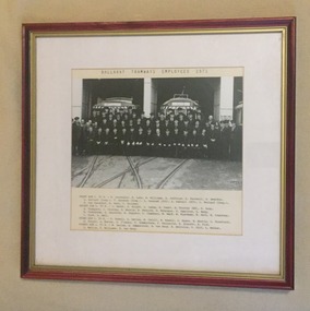
Photograph - Framed Photographs, Williams Studios and Ballarat, 1971
Yields information about the Ballarat tramway staff at the time of closure of the SEC operated system. Demonstrate framing of photographs.Framed Black and white photograph, mounted (partly loose) onto heavy card of the SEC Ballarat tram crews shortly before the closure of the tramway system in front of the depot building with three tramcars behind. Has a printed list of all employees or staff underneath. Titled "Ballarat Tramways Employees 1971". Frame - wooden, red stained wood with a painted gold coloured frame, glazed, with a cut cardboard piece on stippled paper. Rear backing sheet - brown leather type printed finish with a fold out section stapled to the rear to enable the photograph to be stood upright. Backing piece has been nailed to the frame. See Reg Item 1861 for further details of the photograph and list of employees.trams, tramways, ballarat, sec crews, personnel, staff photo, closure -
 Ballarat Tramway Museum
Newspaper, The Courier Ballarat, "Trams out in force for special day", 28/09/1992 12:00:00 AM
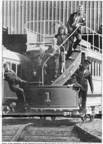
Newspaper cutting from The Courier, Ballarat, Monday Sept. 28, 1992, page 3 of the celebration of the Museum by operating trams along the shore of Lake Wendouree for almost 17 hours to mark the 21st anniversary of the closure of the Ballarat system. Includes a photo of a group of members sanding on the front of Horse Tram No. 1 - Len Millar, Frank Puls, David O' Neil, Alastair Reither, Colleen Low, John Phillips, Andrew Mitchell and Richard Gilbert. Includes comments by Richard Gilbert on the Museum, its Collection Policy and the winners of the colour competition including details of the prizes. Photo by Lachlan Bence and story by Kim Norbury. 2nd copy added 24/5/2006 Image of newspaper with text added 28/3/2011trams, tramways, 21st anniversary, horse tram no. 1, btm, celebrations -
 Ballarat Tramway Museum
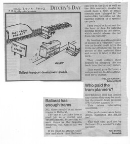
Newspaper, The Courier Ballarat, "Ballarat has enough trams", "Who paid the tram planners?", 7/08/2002 12:00:00 AM
Newspaper cutting from the Letters to the Editor Section of The Courier, Ballarat dated 7/8/2002 regarding the reintroduction of trams to Ballarat. Letter to the Editor titled - "Ballarat has enough trams" - written by Thelma Rungkat, suggesting that a City tramway was not needed, but a system of coin operated electric cars would suffice. Letter to the Editor, by Tom Evans of Creswick titled "Who paid the tram planners", questioning who paid the consultants - the City of Ballarat Ratepayers? Also has a cartoon by inkcinct, titled Ballarat Transport development speeds, with the fast train at 0kmph and the tram restoration project at 6kmph, passing a 'test you speed' sign. 2nd Copy added 12-1-2016 from donation of Kathy Stanley."Courier 7.8.02" in blue ink on top of cutting, Second copy - Has date and page number written in under headline in ink.ballarat revival, letter to the editor, ballarat city tramway, city of ballarat -
 Ballarat Tramway Museum
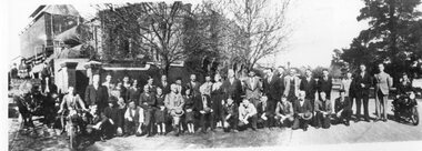
Photograph - Black & White Photograph/s, 1920s
Yields information about the ESCo / SEC employees based at Ballarat A Power station, with some names known or identified on the photograph.566 - black and white photographs, copy photograph of group of employees, photographed in front of Ballarat Powerhouse (later Ballarat A), with horse drawn vehicle in entry gate, over tram tracks and employees either standing or kneeling. Five employees, three men and two ladies are seated, and two are riding motor cycles. See attached notes for some names and details. This photo added 28/7/2007 - has a brown discolouration in the centre of the photo. Printed for Alan Bradley by John Phillips c1996. 566 - A4 photograph in AS Box 54. 566 A and B - 6 x 4 photographs in AS Box 52. Two part prints (enlargements) A & B of above photo - was original images added into the system. Printtrams, tramways, ballarat power station, personnel, esco, employees -
 Beechworth RSL Sub-Branch
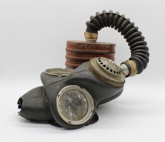
Gas mask, c 1942
This gas mask dates to 1942 in the Second World War. This mask is representative of a style of gas mask that was widely distributed during the Second World War, and can be found in other Australian collections. Rubberised face mask with two circular plastic windows with metal rim for sight by wearer. The mask is fitted by six black elastic straps with red and yellow stripes, which are attached via metal buckles at six points at the top, middle and bottom of the face. Straps converge on rubber backed fabric cross-shaped component which is stamped. Over mouth area is a filter comprised of several layers of metal sheeting with holes. At chin, a metal fitting fits into a black rubber concertina tube which fits into the top of a rounded rectangular container with ribbed edges. Both attachment points have what appears to be adhesive fabric tape wrapped around the closure, possibly to make the system air tight.On cross-shaped component, "No 410/22-12-42" Stamped on mask, "O.T.R.C/6/42", "NORMAL" Filter mask stamped with, "EBRO/1942", "No 4/G.P. 1942" Canister stamped with "WILLOW/[broad arrow]/ML42(?)3/GS174". On canister base "No4A/WILLOW/1942/257/EVI" gas mask, breathing apparatus, chemical warfare, second world war, world war ii, world war 2 -
 Flagstaff Hill Maritime Museum and Village
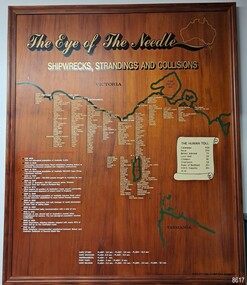
Artwork, other - Shipwreck Board, The Eye of the Needle: Shipwrecks, Stranding's and Collisions, ca 2002
The Shipwreck Board is a feature of Flagstaff Hill Maritime Museum and Village/ its subject is explained briefly in the Museum's handbook, The Flagstaff Hill Navigator, published in 2008: - "Known as the ‘Eye of the Needle’ the treacherous entrance to Bass Strait is littered with the wreckage of large international vessels and smaller sail and steam craft used in coastal trade. The vessels bringing emigrants and cargo to Australia found the western entrance to Bass Strait the most dangerous part of their voyage. They had to thread their way between the southern point of Victoria (Cape Otway) and the northern point of King Island, a stretch of water less than 90 km wide. Many smaller coastal vessels were lost at Portland, Port Fairy, Warrnambool and Apollo Bay which are not safe harbours in certain weather conditions. "The Shipwreck Board shows shipwrecks, strandings and collisions which occurred in this area up to the year 1940. Wrecks are identified by a yellow light and collisions/strandings by a green light. These lights also identify the decade the wreck occurred by lighting up when the relevant decade button is pushed. Interesting happenings of the decades are listed next to the buttons." The Shipwreck Board's demonstration of The Eye of the Needle is an interactive visual display that helps teach the perils and dangers faced by early settlers in Victoria. It tells of the vast number of lives lost. It lists the names of many infamous shipwrecks and significant events.The large stained and lacquered timber board is mounted in a timber, frame. It is painted with a small sketch of Australia, and an enlarged outline of the southern coast of Victoria, King Island and the North West coast of Tasmania. The interactive display highlights the shipwrecks, standings and collisions suffered by many vessels as they navigated the 'Eye of the Needle', a narrow stretch of Bass Strait. The locations of the Lighthouses are pinpointed. Lists of groups of ships are below the coastlines. A painted scroll shows eight major shipwrecks with the number of lives lost for each one. A table shows historical facts associated with the decades from pre-1830 to 1940. A system of coloured lights compares the decades with the vessels that suffered damage. The board was created by artist and signwriter, Alex O'Flynn Computer Signs.flagstaff hill, maritime museum, maritime village, shipwreck coast, eye of the needle, shipwreck locations, bass strait, basses strait, king island, north west tasmania, south coast of victoria, cape otway, victorian lighthouse, king island lighthouse, strandings, coastal tracers, emigrant ships, sea trade, 1930s-1940s, shipwreck board, the eye of the needle, collosions, alex o'flynn, alex o’flynn computer signs, shipwrecks of western victoria -
 Ballarat Tramway Museum
Document - Photocopy, Dave Macartney, Drawing of ESCo Ballarat Tramways, c1990
Photocopy of a drawing prepared by Dave Macartney in the mid 1980's of the track layout of the Electric Supply Co. of Victoria's Ballarat Tramway system, excluding the single track to Sebastopol. Plan shows the location of the loops, loop type, street names, position of replacement loops installed by the SEC during the reconstruction, depot layout, powerhouse siding and railway in Lydiard St. North. Prepared from inspecting the Plans of Ballarat services drawings in the Ballarat Water Board's Offices. Drawn on the back of old import forms of a light weight paper and has shown through the printing underneath. Titled "Ballarat Tramways Company Days 1905 - 1930" Number of small differences to the map drawn for Keith Kings, "The Ballarat Tramways" book, page 22.trams, tramways, ballarat, esco, track layout, map -
 Melbourne Tram Museum
Pamphlet, Public Transport Victoria (PTV), "Check if you can travel on a concession fare", late 2017 to 4/19
.1 - Three fold, DL titled "Check if you can travel on a concession fare", issued late 2017 early 2018 with images of allowable concession cards, including senior and other concession card. ..2 - Five fold DL titled "Your go-to guide to myki" explaining the Myki system costs, types, the Explorer pack for visitors and has a map of the CBD Free Tram Zone. .3 - two fold DL titled "Explore the Night" giving details of night services for trains, trams, bus and coaches. .4 - three fold DL update of .1, issued April 19. Has contact details, languages and Transport for Victoria logo with PTV web address. Printed on recycled paper.trams, tramways, fares, tickets, myki, concession fares, public transport, free tram, night trams -
 Melbourne Tram Museum
Functional object - Run Number Plate, Melbourne & Metropolitan Tramways Board (MMTB), Malvern M74, 1960's to 1970's
Pressed metal plate with corners trimmed and rounded, top section partly folded with two slotted holes, four with sides folded to give strengthening to the plate, painted with a white background and the letter "M" and numbers painted in red, to give a Run Number Plate for Malvern Depot. Painted with the same detail on either side of the plate. Used by Malvern Depot until they were phased out and replaced with the Automatic Vehicle Monitoring system c1990. Used to identify the depot and "run number" or timetable that the tram was running on, two in each tram, to enable monitoring by inspectors and crews. M74 See Also Reg Item 189 and associated item for other examples of Malvern plates. Strengthening of the plate was the result of damage by crews to the plain sheet type.trams, tramways, mmtb, timetables, buses, trams, inspectors, malvern depot -
 Melbourne Tram Museum
Document - Radio Transcript, Melbourne & Metropolitan Tramways Board (MMTB), "Wireless address 3LO by Mr Alex Cameron, Chairman MMTB 12 Jan 1930 - 745pm - Our Trams and Safety", 12/01/1930 12:00:00 AM
Radio transcript - 10 foolscap sheets, typed, titled "Wireless address 3LO by Mr Alex Cameron, Chairman MMTB 12 Jan 1930 - 745pm - Our Trams and Safety". Introduction refers to a request from the Safety Council of Australia, about safety around trams. Notes braking systems, tramcar maintenance, Preston Workshops, training, medical examinations, accident statistics, cable trams, more accidents with cable cars, knock downs mainly in the city, step accidents, crowding on trams, passengers knocked down by motor cars, tram stops, safety zones, traffic regulation, motor traffic, motor vehicle licencing, parking, and lane markings. Has a lists of don't for motorists, pedestrians and passengers.trams, tramways, radio stations, accidents, behaviour, driver training, brakes, safety, medical, cable trams, statistics, motor vehicles, traffic control -
 Melbourne Tram Museum
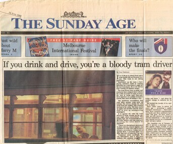
Newspaper, The Age, "If you drink and drive, you're a bloody tram driver", "Taking Victoria for a ride", 14/06/1992 12:00:00 AM
Set of two Newspaper clippings about the public transport and political and financial issues, both The Age 14/6/1992 .1 - Front page of The Sunday Age, "If you drink and drive, you're a bloody tram driver", written by Tony Parkinson, with a photo by Wayne Ludbey of a driver with a stubbie in hand at the Albert Park terminus. Item about this and the financial performance of the system and the operational aspect of crew management. .2 - "Taking Victoria for a ride"- Tony Parkinson - looking at the performance of the Labor Government in addressing Victorian public transport operations and costs, including the railways, unions, the Premier John Cain, Transport Ministers Steve Crabb, Tom Roper, Jim Kennan and Peter Spyker's attempts and problems of the era. PTC, costs.trams, tramways, operations, transport, public transport, unions, finances, redundancies, transport minister -
 Melbourne Tram Museum
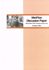
Document - Report, The Met, "MetPlan discussion Paper - Metropolitan Public Transport Industry Plan, Oct. 1987
Report or discussion paper, 76 pages printed on off white paper, with card cover, centre stapled, titled "MetPlan discussion Paper - Metropolitan Public Transport Industry Plan - October 1987". Prepared by Metropolitan Transit authority and Ministry of Transport, signed by the Kevin Shea as Managing Director the MTA. Has a summary of contents, table of contents, many figures and tables (see images 2 and 3). Looks at the current policies and objectives, Melbourne's urban development and public transport system, financial and staff picture, future public transport needs and planning the development of a future service. Gives details of book designers and printers on the last page. Second copy from donation of John Prideaux added 24-6-2016trams, tramways, metplan, minister for transport, public transport, the met, mta, melbourne -
 Melbourne Tram Museum
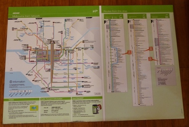
Poster, Yarra Trams, "Melbourne Tram Network" and "Routes from this Stop", Dec. 2012
Full colour poster printed on a vinyl plasticized based sheet, titled "Melbourne Tram Network" - showing a diagrammatic layout of Melbourne tram routes, Myki ticket notes and where tickets can be obtained, information numbers (PTV, phone applications) and information on Tram Tracker, twitter and other contact systems on the left side. On the right side titled "Routes from this Stop" is the information and detailed plan of every stop on routes 3, 3a, 16 and 96, including buses and train stop and connecting tram services. Printed for Stop 136, The Esplanade. Map shown as effective April 2011, printed December 2012. Has the document information on the right hand side of the poster. Two copies held.trams, tramways, yarra trams, ptv, maps, tramtracker, myki, the esplanade, route 96, route 3, route 16 -
 Orbost & District Historical Society
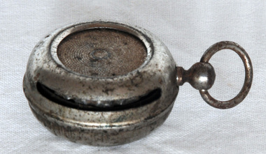
sovereign case, Early 20th century
Coins are one of the worlds oldest types of currency, though the worlds first coins were very basic . They first began to appear in the ancient world and by the time of the Roman and Greek civilisations, coins were being issued in a range of denominations with quite sophisticated designs. With coins being used instead of older systems such as barter, people needed a way to carry and store their money and the coin holder appeared on the scene. Sovereign cases were small portable boxes usually in cylindrical shape and made from various metals with snap shut covers to contain the coin. This one is kept safe by being attached to a fob chain. The silver sovereign holder was used for carrying either full or half gold sovereigns. It had the shape of a locket or of a watch and was often worn on a chain and kept by gentlemen in a waist coat pocket. This item is an example of a commonly used sovereign case.A small round metal ( nickel plated?) sovereign coin holder. it has a spring opening with a slot for insertion of coin, It has a link attached to top.currency coin sovereign-case personal-effects -
 Glen Eira Historical Society
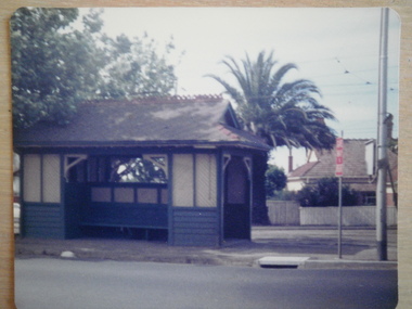
Article - Tram Shelter, Balaclava Road
Caulfield Conservation study by Andrew Ward dated October 1994 on Tram Shelter, corner of Balaclava Road and Orrong Road with a brief history and a statement of significance from the National Trust of Australia. Four black and white photos of Balaclava Road tram shelter. National Trust classification report giving detail of shelter and others on the tramway routes of Melbourne. Includes history of cable car system and reasons for tramways amalgamations. It includes architectural features. Article from the Trust News, June 2000 on history of Melbourne Tram shelters, various architectural design and features and where they were built and who designed thembalaclava road, orrong road, tram shelters, street furniture, cast iron work, verandahs, edwardian style, the prahran and malvern tramways trust, ward andrew, historic buildings, dandenong road, caulfield north, glenhuntly road, green robert -
 Federation University Historical Collection
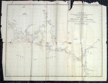
Map, British New Guinea, 1893, 1893
The map was surveyed by ship compass, distances by estimation or rate of launch by officers of the Government ; supervised and compiled by J.B. Cameron, G.S. March 1893. This map was in the possession of Charles Carty Salmon (1860-1917), politician, born on 27 July 1860 at Amherst, Victoria. (http://adb.anu.edu.au/biography/salmon-charles-carty-8328 ) Although living in Melbourne Charles Carty Salmon kept property at Talbot. The property was leased, then purchased by the donor's family. A copy of "The Goulburn Weir and its Dependent System of Works" and this map (in a government envelope addressed to Salmon) were left at the property. See http://nla.gov.au/nla.map-rm1894-1 .1) Sketch map showing the rivers and an outline of the coast from Long. 144?30'E. to Long. 146?30'E. Gulf of Papua British New Guinea Scale [ca. 1:316,800]. .2) Large envelope addressed to The Hon Charles Carty Salmon M.P., Talbot, Victoria. The map was folded and stored in this envelope. Map extending from Port Bevan to Kaikavau Pt, showing rivers and notes on soil and vegetation. Relief shown by hachures and spot heights. Also available in an electronic version via the Internet at: http://nla.gov.au/nla.map-rm1894-1 .1) "Enclosure in Despatch No. 32 of 3rd May 1893 - Appendix G.". "Map no. 4 British New Guinea report 1892-93". .2) "This envelope can only be lawfully used by Government Officials on public business. Any use by Officials on private business, or by others under any circumstances, is punishable." "Commonwealth Celebrations. General Secretary's Office, Melbourne."carty salmon, charles carty salmon, new guinea, j.b. cameron -
 Flagstaff Hill Maritime Museum and Village
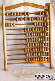
Article - Abacus, Probably second half of 19th Century or first half of the 20th Century for this particular item
The abacus has been used by many civilisations, and is still in use today. Its origin is masked in the depths of time, but it is believed to have originated in crude form around the years c.2500 BCE. It is interesting to note that this abacus, although in use in Australian schools, contains ten rows, each containing ten beads, suggesting that it was heavily influenced by the decimal system. The number 12 was quite prominent in Australia, no doubt introduced by the British during the first settlements. It's use, as in dozens, twelve shillings in the pound and twelve inches in a foot, was widespread until decimalisation in 1966. Even today, many items are sold in dozens or sixes.Before more sophisticated adding machines and then calculators were developed in the 19th and 20th centuries, the abacus would have been in worldwide use.Abacus or counting frame with ten rows, each containing ten wooden beads.Noneflagstaff hill, warrnambool, shipwrecked-coast, flagstaff-hill, flagstaff-hill-maritime-museum, maritime-museum, shipwreck-coast, flagstaff-hill-maritime-village, wood, abacus -
 Federation University Historical Collection
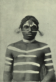
Image - black and white, Barwon River Man (New South Wales)
Digitised directly from 'The Native Races of the British Empire: Victoria' The Barwon River in New South Wales is formed through the confluence of the Macintyre River and Weir River (part of the Border Rivers system), north of Mungindi, in the Southern Downs region of Queensland. The Barwon River generally flows south and west, joined by 36 tributaries, including major inflows from the Boomi, Moonie, Gwydir, Mehi, Namoi, Macquarie, Bokhara and Bogan rivers. During major flooding, overflow from the Narran Lakes and the Narran River also flows into the Barwon. The confluence of the Barwon and Culgoa rivers, between Brewarrina and Bourke, marks the start of the Darling River.Black and white Image of an Aboriginal man from Barwon River, New South Wales. Aboriginal people from six language groups originally occupied the area of the Barwon River wetlands. These were the Ngemba, the Baranbinja, the Murrawari, the Ualayai, the Weilwan, and the Kamilaroi peoples. The Aboriginal people generally used the wetlands for hunting, fishing, and gathering uses, and for cultural association.(Wikipedia) The name "barwon" is derived from the Australian Aboriginal words of barwum or bawon, meaning great, wide, awful river of muddy water; and also baawan, a Ngiyambaa name for both the Barwon and Darling rivers. The history, culture and livelihoods of the local Aboriginal people are closely intertwined with the Barwon River and its associated tributaries and downstream flows. (Wikipedia)aborigine, aboriginal, barwon river -
 Unions Ballarat
Why You Should be a Socialist, Strachey, John, 1938
The book describes itself as a "terse guide to such questions as, what causes unemployment, what causes war, what makes booms and slumps, what is socialism [and] what is capitalism." Book index: I. The Secret in the Pay Envelope II. How the System Works III. What They Get Out of It IV. What It has Done to Us V. Why It Stops Working VI. Must we Die for It? VII. What can we Put in its Place? VIII. "I have Seen the Future, and It Works" IX. What would Socialism be like Here? X. How to Get There Written and produced in Britain 1938. Pertinent Britain's economy and work force in the 1930s. Observations about wages and employment.Softcover book. Front cover: black and white background, red, white and black lettering. Back cover: white background; black lettering.Front cover: title and author's name. Back cover: advertisement for the Left Book Club, London; International Bookshop Pty Ltd stamp.btlc, ballarat regional trades and labour council, ballarat trades hall, socialism, politics and government, unemployment, war, economy, capitalism, wages -
 Kew Historical Society Inc
Plan, Melbourne & Metropolitan Board of Works : Borough of Kew : Detail Plan No.1576, 1904
The Melbourne and Metropolitan Board of Works (MMBW) plans were produced from the 1890s to the 1950s. They were crucial to the design and development of Melbourne's sewerage and drainage system. The plans, at a scale of 40 feet to 1 inch (1:480), provide a detailed historical record of Melbourne streetscapes and environmental features. Each plan covers one or two street blocks (roughly six streets), showing details of buildings, including garden layouts and ownership boundaries, and features such as laneways, drains, bridges, parks, municipal boundaries and other prominent landmarks as they existed at the time each plan was produced. (Source: State Library of Victoria)This plan forms part of a large group of MMBW plans and maps that was donated to the Society by the Mr Poulter, City Engineer of the City of Kew in 1989. Within this collection, thirty-five hand-coloured plans, backed with linen, are of statewide significance as they include annotations that provide details of construction materials used in buildings in the first decade of the 20th century as well as additional information about land ownership and usage. The copies in the Public Record Office Victoria and the State Library of Victoria are monochrome versions which do not denote building materials so that the maps in this collection are invaluable and unique tools for researchers and heritage consultants. A number of the plans are not held in the collection of the State Library of Victoria so they have the additional attribute of rarity.Original survey plan, issued by the MMBW to a contractor with responsibility for constructing sewers in the area identified on the plan within the Borough of Kew. The plan was at some stage hand-coloured, possibly by the contractor, but more likely by officers working in the Engineering Department of the Borough and later Town, then City of Kew. The hand-coloured sections of buildings on the plan were used to denote masonry or brick constructions (pink), weatherboard constructions (yellow), and public buildings (grey). Development in the 20th century has irreparably altered that part of Kew represented in this plan. In the block bounded by Cotham Road, Charles Street, Wellington Street and Gellibrand; just one house standing in 1903 remains. This block included two of the most historic houses in Kew: ‘Ordsall’ (later ‘Southesk’) and ‘Madford’ (previously ‘Elm Lodge’). Ordsall was the home of the second chairman of Kew, John Halfey. It contained some of the most significant interior murals in Kew, created for Halfey by artists working for Cullen & Co. It was demolished in 1960 to make way for the Kew Civic Centre. Elm Lodge had been built for William Siddeley in ca. 1864. Arthur Septimus King purchased it in 1874. The lower paddocks of Madford were sold in 1905 by his wife to the Borough of Kew and, after landscaping by George and Thomas Pockett, opened as the Alexandra Gardens in 1908. Elm Lodge/Madford was in 1922 to become St. Anthony’s Home for Little Children before its subsequent demolition in the 1980s.melbourne and metropolitan board of works, detail plans, maps - borough of kew, mmbw 1576, cartography -
 Kew Historical Society Inc
Plan, Borough of Kew Detail Plan No.1577, 1904
The Melbourne and Metropolitan Board of Works (MMBW) plans were produced from the 1890s to the 1950s. They were crucial to the design and development of Melbourne's sewerage and drainage system. The plans, at a scale of 40 feet to 1 inch (1:480), provide a detailed historical record of Melbourne streetscapes and environmental features. Each plan covers one or two street blocks (roughly six streets), showing details of buildings, including garden layouts and ownership boundaries, and features such as laneways, drains, bridges, parks, municipal boundaries and other prominent landmarks as they existed at the time each plan was produced. (Source: State Library of Victoria)This plan forms part of a large group of MMBW plans and maps that was donated to the Society by the Mr Poulter, City Engineer of the City of Kew in 1989. Within this collection, thirty-five hand-coloured plans, backed with linen, are of statewide significance as they include annotations that provide details of construction materials used in buildings in the first decade of the 20th century as well as additional information about land ownership and usage. The copies in the Public Record Office Victoria and the State Library of Victoria are monochrome versions which do not denote building materials so that the maps in this collection are invaluable and unique tools for researchers and heritage consultants. A number of the plans are not held in the collection of the State Library of Victoria so they have the additional attribute of rarity.Original survey plan, issued by the MMBW to a contractor with responsibility for constructing sewers in the area identified on the plan within the Borough of Kew. The plan was at some stage hand-coloured, possibly by the contractor, but more likely by officers working in the Engineering Department of the Borough and later Town, then City of Kew. The hand-coloured sections of buildings on the plan were used to denote masonry or brick constructions (pink), weatherboard constructions (yellow), and public buildings (grey). MMBW Plan No.1577 includes some of the most significant houses in Kew: Herbert Henty’s ‘Roxeth’ (now part of Trinity Grammar), ‘Butleigh Wooton’, ‘Bokara’ and ‘Harrow’. It also includes the streets that have since changed their names. That part of College Parade linked to Glenferrie Road is now named College Place, College Parade now extends further north, and Charles Street did not yet reach Barkers Road. Roxeth is one of a number of Henty houses in Kew. Herbert Henty made his home here and was elected a member of Kew Municipal Council in 1864 and mayor in 1868-69. Walter Henry Serle, of Harrow served in the First World War. He was awarded the Military Medal ‘’For conspicuous bravery and devotion to duty. On 29th September near BELLICOURT he showed the greatest bravery and determination when his platoon was attacked by enemy bombing parties. It was due largely to his personal efforts that all the attacks were repulsed. Until wounded, his utter disregard of personal safety and boldness in dealing with the attacks were the means of saving the situation and were an inspiring example to his men.’melbourne and metropolitan board of works, detail plans, maps - borough of kew, mmbw 1577, cartography -
 Kew Historical Society Inc
Plan, Melbourne & Metropolitan Board of Works : Borough of Kew : Detail Plan No.1578, 1904
The Melbourne and Metropolitan Board of Works (MMBW) plans were produced from the 1890s to the 1950s. They were crucial to the design and development of Melbourne's sewerage and drainage system. The plans, at a scale of 40 feet to 1 inch (1:480), provide a detailed historical record of Melbourne streetscapes and environmental features. Each plan covers one or two street blocks (roughly six streets), showing details of buildings, including garden layouts and ownership boundaries, and features such as laneways, drains, bridges, parks, municipal boundaries and other prominent landmarks as they existed at the time each plan was produced. (Source: State Library of Victoria). This plan forms part of a large group of MMBW plans and maps that was donated to the Society by the Mr Poulter, City Engineer of the City of Kew in 1989. Within this collection, thirty-five hand-coloured plans, backed with linen, are of statewide significance as they include annotations that provide details of construction materials used in buildings in the first decade of the 20th century as well as additional information about land ownership and usage. The copies in the Public Record Office Victoria and the State Library of Victoria are monochrome versions which do not denote building materials so that the maps in this collection are invaluable and unique tools for researchers and heritage consultants. A number of the plans are not held in the collection of the State Library of Victoria so they have the additional attribute of rarity.Original survey plan, issued by the MMBW to a contractor with responsibility for constructing sewers in the area identified on the plan within the Borough of Kew. The plan was at some stage hand-coloured, possibly by the contractor, but more likely by officers working in the Engineering Department of the Borough and later Town, then City of Kew. The hand-coloured sections of buildings on the plan were used to denote masonry or brick constructions (pink), weatherboard constructions (yellow), and public buildings (grey). MMBW Plan No.1578 is significant in that it defines the extent of two private schools: Xavier College and Kew High School (now part of Trinity Grammar) by 1904. In relation to the latter, the plan clarifies which buildings the High School operated from behind the mansion ‘Molina’. Established in 1902, Trinity Grammar was to later lease and subsequently buy Molina (now ‘Merritt House’) and ‘Elsinore’ (now ‘Roberts House’). Xavier College had been established in 1872. This 1904 plan delineates the West Wing and the Great Hall (built in 1890).melbourne and metropolitan board of works, detail plans, maps - borough of kew, mmbw 1578, cartography -
 Kew Historical Society Inc
Plan, Melbourne & Metropolitan Board of Works. Borough of Kew Detail Plan No.1579, 1904
The Melbourne and Metropolitan Board of Works (MMBW) plans were produced from the 1890s to the 1950s. They were crucial to the design and development of Melbourne's sewerage and drainage system. The plans, at a scale of 40 feet to 1 inch (1:480), provide a detailed historical record of Melbourne streetscapes and environmental features. Each plan covers one or two street blocks (roughly six streets), showing details of buildings, including garden layouts and ownership boundaries, and features such as laneways, drains, bridges, parks, municipal boundaries and other prominent landmarks as they existed at the time each plan was produced. (Source: State Library of Victoria). This plan forms part of a large group of MMBW plans and maps that was donated to the Society by the Mr Poulter, City Engineer of the City of Kew in 1989. Within this collection, thirty-five hand-coloured plans, backed with linen, are of statewide significance as they include annotations that provide details of construction materials used in buildings in the first decade of the 20th century as well as additional information about land ownership and usage. The copies in the Public Record Office Victoria and the State Library of Victoria are monochrome versions which do not denote building materials so that the maps in this collection are invaluable and unique tools for researchers and heritage consultants. A number of the plans are not held in the collection of the State Library of Victoria so they have the additional attribute of rarity.Original survey plan, issued by the MMBW to a contractor with responsibility for constructing sewers in the area identified on the plan within the Borough of Kew. The plan was at some stage hand-coloured, possibly by the contractor, but more likely by officers working in the Engineering Department of the Borough and later Town, then City of Kew. The hand-coloured sections of buildings on the plan were used to denote masonry or brick constructions (pink), weatherboard constructions (yellow), and public buildings (grey). While MMBW Plan No.1579 does not include many buildings, those that it does show are significant to Kew’s history. These include the ‘Kew [Railway] Station’ in Denmark Street and the ‘Recreation Hall’ and rear courts off Wellington Street. The plan shows the outline of the Recreation Hall, constructed in 1880, at the rear of which is listed a bowling green, two tennis courts, a ‘skittle alley’ and a pavilion. When the Hall was first built, the Kew Cricket Club occupied an adjacent ground, however in 1885 this was acquired by the State Government as the future location of the Kew Railway Station. The Plan also shows a single oval at Xavier College. This oval was completed in 1883. One of the current ovals conforms to this oval’s original shape and position in the school grounds.melbourne and metropolitan board of works, detail plans, maps - borough of kew, mmbw 1579, cartography -
 Kew Historical Society Inc
Plan, Melbourne and Metropolitan Board of Works, Borough of Kew : Detail Plan No.1580, 1904
The Melbourne and Metropolitan Board of Works (MMBW) plans were produced from the 1890s to the 1950s. They were crucial to the design and development of Melbourne's sewerage and drainage system. The plans, at a scale of 40 feet to 1 inch (1:480), provide a detailed historical record of Melbourne streetscapes and environmental features. Each plan covers one or two street blocks (roughly six streets), showing details of buildings, including garden layouts and ownership boundaries, and features such as laneways, drains, bridges, parks, municipal boundaries and other prominent landmarks as they existed at the time each plan was produced. (Source: State Library of Victoria)This plan forms part of a large group of MMBW plans and maps that was donated to the Society by the Mr Poulter, City Engineer of the City of Kew in 1989. Within this collection, thirty-five hand-coloured plans, backed with linen, are of statewide significance as they include annotations that provide details of construction materials used in buildings in the first decade of the 20th century as well as additional information about land ownership and usage. The copies in the Public Record Office Victoria and the State Library of Victoria are monochrome versions which do not denote building materials so that the maps in this collection are invaluable and unique tools for researchers and heritage consultants. A number of the plans are not held in the collection of the State Library of Victoria so they have the additional attribute of rarity.Original survey plan, issued by the MMBW to a contractor with responsibility for constructing sewers in the area identified on the plan within the Borough of Kew. The plan was at some stage hand-coloured, possibly by the contractor, but more likely by officers working in the Engineering Department of the Borough and later Town, then City of Kew. The hand-coloured sections of buildings on the plan were used to denote masonry or brick constructions (pink), weatherboard constructions (yellow), and public buildings (grey). The area represented in this detail plan has undergone significant change during the 20th century. The widening of High Street in the 1930s and 1950s involved the shops on the south side of High Street being demolished and later rebuilt to fit the widened street. Another significant loss was the mansion ‘Drayton’ fronting Wellington Street, owned at this stage by Susannah Fenton. Her family name would later to be given to Fenton Way, which was to be built over the grounds of the house following its demolition. The plan of the garden is particularly interesting, containing a batten dome fronting Wellington Street, an ornamental pond, a fountain and a brick and glass conservatory. The notes by the plumbing contractor on this plan are particularly detailed. Pink borders delineate the ownership of the varying parcels of land. Some of the better known owners listed include the real estate agent Cr. Henry de Castres Kellett (bt) and John Padbury, the funeral director. This particular plan provides a clear view of the configuration of the Kew Junction in 1903 and the commercial buildings that surrounded it.melbourne and metropolitan board of works, detail plans, maps - borough of kew, mmbw 1580, cartography