Showing 640 items
matching footpaths
-
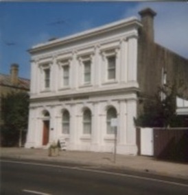
 Clunes Museum
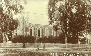
Postcard, ST PAULS CHURCH
IMAGE OF ST. PAULS CHURCH CLUNES WITH TWO TALL GUM TREES EITHER SIDE - WHITE PICKET FENCE IN FRONT AND THREE CHILDREN WALKING ALONG FOOTPATH. .1 ORIGINAL SEPIA POSTCARD .2 SEPIA PHOTOCOPY OF POSTCARD .3 1 ENLARGED BLACK AND WHITE PHOTOGRAPHIC PRINT .4.1 ENLARGED PHOTOCOPY OF POSTCARDPRINTED IN WHITE AT THE BOTTOM ON EACH IMAGE "ST. PAUL'S CHURCH, CLUNES"local history, churches, st pauls anglican -
 Whitehorse Historical Society Inc.
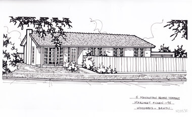
Artwork, other - Ink Line Drawing, Margaret Picken, 5 Manhattan Square., Vermont, 1995
A property illustration by Margaret Picken Commissioned by a real estate agency for the purpose of advertising 6 Lusk Dve., Vermont This property is listed as having sold for $136,000 in 1995 Made by using Rotring ‘Rapidigraph’ drafting pens with Rotring ink on Rapidigraph polyester drafting film, double matte. Trained as a cartographic draftsman within the mining industry, Margaret Picken is an artist who worked producing property illustrations for real estate agencies in eastern suburbs of Victoria from 1983-2005. Retiring from the industry as technological changes favored coloured photography over illustrations, and commissioning companies over sole contractors.This artwork is of Historical Significance as a record of local domestic architecture.A black ink line drawing on drafters film by Margaret Picken, of a single story brick house with a path up to the front door from the footpath in the foreground. On the left is a front lawn, and on the left is a timber fence enclosing the other half of the property frontage. There are two hole punch holes just below centre of the upper edge5 Manhattan Square., Vermont Margaret Picken - 95 Woodards - Balwynwhitehorse historical society, schwerkolt cottage, housing, architecture, margaret picken, house, garden, real estate, vermont, vermont south -
 Glenelg Shire Council Cultural Collection
Photograph - Photograph - Unknown double story building, c. 1970
Photographic print of a rephotographed photograph. Image shows double storey building with pitched iron roof and fenced balcony on first floor, attached to single storey building with slate roof, 2 large multi-paned windows and partly open front door. Small child in open doorway, man in top hat and small boy on footpath. -
 Federation University Historical Collection
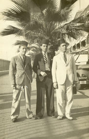
Photograph - Black and White, Three Men at Port Said, 1933, 4/9/1933
Frank Wright was a renown resident of Smeaton, where he was born. He lived at Laura Villa, and attended Smeaton State School. His father William was a gold miner and his mother's name was Sarah. Their family won many singing and instrumental awards. Frank was tutored by Percy Code and was awarded a gold medal for the highest marks in the ALCM examinations in the British Colonies at the age of seventeen years. He became the Australian Open Cornet Champion by the age of eighteen. A year later, Frank conducted the City of Ballarat Band, and later the Ballarat Soldiers’ Memorial Band. He formed the Frank Wright Frisco Band and Frank Wright and his Coliseum Orchestra. These bands won many South Street awards, and Frank as conductor won many awards in the Australian Band Championship contest. In 1933 Frank Wright sailed to England to conduct the famous St Hilda’s Band and was later appointed Musical Director of the London County Council, where he organized many amazing concerts in parks, in and around the London district. He was made Professor of Brass and Military Band Scoring and conducted at the Guildhall of Music and Drama. Frank was often invited to adjudicate Brass Band Championships around Europe, in Australia, including South Street and in New Zealand. The Frank Wright Medal at the Royal South Street competition is awarded to an individual recognized as making an outstanding contribution to brass music in Australia..1) Black and white photograph of three men dressed in suits and wearing Egyptian hats. They are standing on a footpath with a large palm tree behind, a fence to the left and part of a car and building to the right. The men are from the left Tony Hanlon, Dan Barry and Frank Wright. The place is Port Said. .2) Frank Wright wearing an Egyptian hat.Written in pencil on back - Tony Hanlon (left), Dan Barry (centre), Frank Wright, Port Said 4/9/33 Printed on back - Carte Postalefrank wright, dan barry, tony hanlon, port said, conductor -
 Federation University Historical Collection
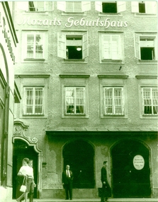
Photograph - black and white, Mozart's Geburthaus, 1963, September 1963
Frank Wright was a renoun resident of Smeaton, where he was born on 2 August 1901. He lived at Laura Villa, and attended Smeaton State School. His father William was a gold miner and his mother's name was Sarah. Their family won many singing and instrumental awards. Frank was tutored by Percy Code and was awarded a gold medal for the highest marks in the ALCM examinations in the British Colonies at the age of seventeen years. He became the Australian Open Cornet Champion by the age of eighteen. A year later, Frank conducted the City of Ballarat Band, and later the Ballarat Soldiers’ Memorial Band. He formed the Frank Wright Frisco Band and Frank Wright and his Coliseum Orchestra. These bands won many South Street awards, and Frank as conductor won many awards in the Australian Band Championship contest. In 1933 Frank Wright sailed to England to conduct the famous St Hilda’s Band and was later appointed Musical Director of the London County Council, where he organized many amazing concerts in parks, in and around the London district. He was made Professor of Brass and Military Band Scoring and conducted at the Guildhall of Music and Drama. Frank was often invited to adjudicate Brass Band Championships around Europe, in Australia, including South Street and in New Zealand. The Frank Wright Medal at the Royal South Street competition is awarded to an individual recognized as making an outstanding contribution to brass music in Australia. He died on 16 November 1970.Black and white photograph of the front of a building. At street level there is an arched window and beside it is an arched double door. Above are levels of paned windows, with the first floor windows barred. Above the second floor windows is the written Mozarts Geburtshaus. On the footpath, along with three pedestrians, there is a man standing facing the camera. The man is Frank Wright and the city is Salzburg.Written in pen on the back - September 1963, Salzburg, Mozart's birthplacefrank wright, mozart, salzburg, mozarts geburtshaus -
 Hume City Civic Collection
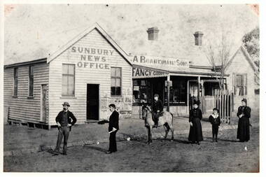
Photograph, Sunbury News Office
The Boardman family were local business people in Sunbury, who were storekeepers and also produced the local newspaper. Their original building was in Brook Street near the railway station but they later located their business further down in Brook Street on the corner of O'Shanassy Street. A black and white photograph with a cream border of a news office, store and cottage with a picket fence. The buildings are weatherboard with corrugated iron roofs.A young tree surrounded by a tree guard has been planted on the footpath between the cottage and shop.Two men and two ladies and a boy are standing in front of the buildings on the unmade road. A boy on horseback is alsoweith the group.j.a. boardman, sunbury news office, businesses., brook street -
 Ballarat Tramway Museum
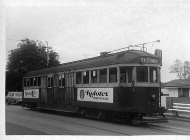
Photograph - Black & White Photograph/s, Ian Barkla, 18/10/1969 12:00:00 AM
Black and white photograph of MMTB tram 541 in Glenferrie Road Toorak, 18-10-69. Tram has destination of "Kew-Cotham Rd", all blinds are drawn and two panel ads for Kolotex hosiery. No driver in cab. Seat on footpath, indicating a stop possibly with a Bundy clock. ( Image on the dark side.) On Kodak paper.On rear in black biro "541 Glenferrie RD, Toorak, / 18-10-69"trams, tramways, melbourne, glenferrie rd. , tram 541 -
 Surrey Hills Historical Society Collection
Photograph, Fred Lyons' hansom cab, c1916, 1916
This is one of a series of photos donated by Arthur Lyons. From 1907 a cab service operated from near the railway gates in Union Road. It was established and maintained by Mr C Fraser until c1916. George Rea either took over then or set up in opposition; he retired in 1945. Fred Lyons initially worked for George until he set up his own business. In time he changed over to a motor vehicle and continued his service until 1960. Frederick Adolphus Lyons (1891-1980) was born in Surrey Hills, son of Thomas and Catherine Lyons. He married Elizabeth Ruby Hall in 1918. They lived just around the corner at 55 Sunbury Crescent. The Lyons’ home in Sunbury Crescent was called ‘Knopshambury’ - this was probably a misspelling of Knockshanbally in Co Kilkenny, the birth place of Fred’s father, Thomas Edmund Josias Lyons (1846-1915). Arthur Lyons was born in Surrey Hills on 12 Jun 1920. He became a motor mechanic / welder and lived at 55 Sunbury Crescent. W T Nisbe... is probably William Thomson Nisbet, traveller of 'Maroona', Brenbeal Street, Balwyn listed in 1903, 1914, 1919 electoral rolls. His wife was Mary Grace Nisbet, son was William Thomson Nisbet Jnr (clerk) and daughter was Olive Thomson Nisbet (dressmaker). The donation was made while he was in hospital. He died shortly afterwards (23 Sep 1990). Donation was finalised by a neighbour, Mrs Florence Ann Armitstead, wife of Glen Victor Armitstead. Glen was a local hairdresser. They moved to 11 Sunbury Crescent after their marriage in 1939. Arthur had no relatives to distribute the material to.Black and white photo of Fred Lyons in one of his hansom cabs with his horse 'Barney' taken near Surrey Hills railway station. Another hansom cab is to the right of the photo and there is another man standing on the footpath. In the background are shops and the partial hoarding of W T Nisbe... is visible. The photo was taken between 1916-1927. On rear of the duplicate print in pencil in Jocelyn Hall's handwriting : "NO 59 / and 89 / Spare ? / perhaps better than enlargement"transport, horse drawn vehicles, businesses, fred lyons, frederick adolphus lyons, william thomas nisbet -
 Surrey Hills Historical Society Collection
Photograph, Fred Lyons, taxi driver of Surrey Hills
This is one of a series of photos donated by Arthur Lyons. From 1907 a cab service operated from near the railway gates in Union Road. It was established and maintained by Mr C Fraser until c1916. George Rea either took over then or set up in opposition; he retired in 1945. Fred Lyons initially worked for George until he set up his own business. In time he changed over to a motor vehicle and continued his service until 1960. Frederick Adolphus Lyons (1891-1980) was born in Surrey Hills, son of Thomas and Catherine Lyons. He married Elizabeth Ruby Hall in 1918. They lived just around the corner at 55 Sunbury Crescent. The Lyons’ home in Sunbury Crescent was called ‘Knopshambury’ - this was probably a misspelling of Knockshanbally in Co Kilkenny, the birth place of Fred’s father, Thomas Edmund Josias Lyons (1846-1915). Arthur Lyons was born in Surrey Hills on 12 Jun 1920. He became a motor mechanic / welder and lived at 55 Sunbury Crescent. The donation was made while he was in hospital. He died shortly afterwards (23 Sep 1990). Donation was finalised by a neighbour, Mrs Florence Ann Armitstead, wife of Glen Victor Armitstead. Glen was a local hairdresser. They moved to 11 Sunbury Crescent after their marriage in 1939. Arthur had no relatives to distribute the material to.Black and white photo of Fred Lyons dressed in suit and cap standing on the footpath beside his taxi. Behind the taxi is another car approaching from a street at right angles. There are wide stretches of grass planted with trees including palm trees. In the background are houses with picket fences; the most visible house is clearly Victorian in style. transport, businesses, taxis, fred lyons, frederick adolphus lyons, uniforms -
 Kilmore Historical Society
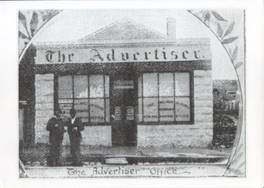
Photograph, 19 Sydney Street
30cm x 21cm black and white photograph of the building at 19 Sydney Street which was occupied by The Advertiser Office. Purchased from the State Library of Victoria. There is two men standing outside of the office which is a light coloured single story building with advertising in the windows and a smal ramp out the front of the building connecting the footpath and the road.Written on the back: Photo purchased from SLV July 2006 1894 19 Sydney Streetnewspapers -
 Kilmore Historical Society
Photograph, 39 Sydney Street, 1980's?
Was the site of the Old Colonial Bank of Australasia Ltd.9.5cm x 10cm coloured photograph of the building at 39 Sydney Street. The double story building has an ornate light-coloured facade, which darker brickwork on the sides. Arched windows on the ground floor and rectangle window with trim on the top floor. Signage on the building states "Dornal Antiques". There is also a planter out the front on the footpath.storefront, shopfront, antiques, antique dealers, retail stores -
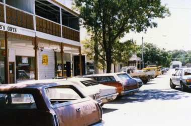 Charlton Golden Grains Museum Inc
Photograph, High St Charlton, Procter's Building c. 1987, c.1987
Ross's Gifts formerly Ike Richards Gents Hairdresser and Gift Shop. Building built in 1880 as Procter's butcher's shop with upstairs residence. Extended to triple frontage in 1884.Colour photograph showing High St looking west. Two storey building with verandah over footpath and cast iron balcony on 2nd storey. Cars parked along the street. Yellow panel van in front of panel beaters. White car just pulling out. Fire Station at the end of the street. Large tree in centre of photo.ross's gifts, ike richards hairdresser, procter, business, charlton -
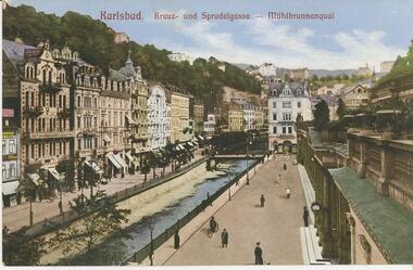 Bendigo Historical Society Inc.
Postcard - ROY AND DORIS KELLY COLLECTION: KARLSBAD, 1900-1920
Postcard, coloured image of Karlsbad a Spa City in the current Czech Republic. On the front are the words 'Kreuz und Sprudelgasse' that translates as 'Cross and Bubble gases' Picture shows a canal with 5 story buildings on the left and part of a colonnaded building on the right. People strolling on footpaths. Also ' Muhlbrunnenquai' On the back is printed '61614 Herman Poy, Dresden'postcard, photograph, postcard, karlsbad, czech republic, germany -
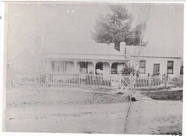 Linton and District Historical Society Inc
Photograph, Original O'Beirne Home on Skipton Road
The original O'Beirne home on the Skipton Road, c.1901. Transported from Ballarat to Linton in 1872 for Henry and Catherine O'Beirne. The cottage on the right was the office of O'Beirne's Wool and Skin Business.Black and white copy of original photograph showing a weatherboard house with verandah and lattice work, next to a smaller building (office) with 2 windows a door and no verandah. One pine tree behind the buildings on the photograph. A light coloured picket fence in front of the buildings with a gate half way along. Two small children on the footpath in front of the house."Original O'Beirne Home Little cottage on the right was the office c.1901"o'beirne house, skipton road linton, c1901, henry and catherine o'beirne, office of o'beirne's wool and skin business. -
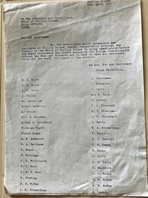 Phillip Island and District Historical Society Inc.
Document, Petition for bridge between Phillip Island and San Remo 1937
On 29 November 1940, a suspension bridge opened between San Remo on the mainland and with Newhaven on Phillip Island. The 540 metre bridge had two lanes but no footpaths, instead having six pedestrian refuges. The main span was 168 metres long. The cables had previously been used on a bridge on Sydney's North Shore. Because of weight restrictions, tourist coaches had to offload their passengers. [Wikipedia]HistoricalFoolscap size photocopy of a petition to Shire of Phillip Island for a bridge to Phillip Island in 1937. Signed by 42 local residents and ratepayers.first phillip island bridge to san remo, phillip island suspension bridge, petition, odlum, ockleford, regos, mcguigan, west, mcfee, richardson, underdown, mcmaster, cleeland, neely, leeson, saunders, scott, brown, hislop, donnellan, rackham, findlay, anderson -
 Eltham District Historical Society Inc
Slide, Joh Ebeli, Preserving parts of the old Baker's house, corner of York Street and Main Road, Eltham, c.Sep. 1979
The old weatherboard building, possibly dating from the 1860s, comprised a dwelling with a shop in the front room opening off a timber verandah deck which directly fronted the Main Road footpath. At the rear is a brick building of much later date which was for many years used for the bakery. The buildings were demolished for flat construction. Joh Ebeli and Elwers Howard endeavoured to preserve some parts of the house.35 mm colour positive transparency Mount - Agfachrome Professional black (Germany) 4 dotsmain road, old eltham bakery, york street -
 Ballarat Tramway Museum
Photograph - Ballarat 15 in Victoria Street, Bob Lilburn, early 1950s
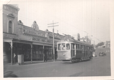
Photo shows Ballarat bogie tram 15 in Bridge Street Ballarat, near Stones Corner. The tram arrived in Ballarat in Oct. 1945 and was renumbered to No. 36 in Sept 1953. Photo early 1950s. In the background is W J Rodda Pty Ltd Grocery, wines and spirits store and Dunstan's leather store. Note the metal box on the footpath - could be an Electric Supply Co. cable power terminal box.Yields information about bogie tram 15, early 1950s.Black and White photograph of Ballarat 15 in Bridge StreetHas in ink on rear " R Lilburn"ballarat, tramways, trams, stones corner, bridge st, tram 15, esco, w j rodda -
 Vision Australia
Photograph - Image, Kevin Stapleton and Wally Urgacz using their white canes, 1969
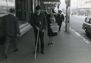
RBS client Kevin Stapleton uses a white cane as he descends church steps, crosses a road and walks along the footpath. Another RBS client, Wally Urgacz, walks behind Kevin as he crosses the road in the Sydney CBD. Wally Urgacz steps off the Bondi Beach bus and up a flight of stone stairs using his Hoover long cane, under the purview of Margaret Rihr.5 x B/W photographs of men using a white caneMobility - historicalroyal blind society of nsw, white cane day, kevin stapleton, wally urgacz, margaret rihr -
 City of Kingston
Photograph - Black and white, c. 1958
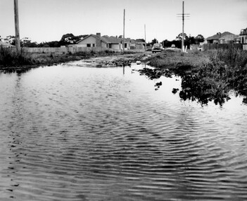
This photograph depicts flooding of Ozone Avenue in Beaumaris, located off Balcombe Road. Roads in the Beaumaris area lacked sufficient drains to clear surface water. In many cases streets were unsealed and without footpaths and some were dirt tracks. Gutters and road surfaces were made of clay and in the wetter months of winter, unsealed roads and tracks became impossible quagmires that were unnavigable for vehicles and pedestrians. In the first decade after World War II there was rapid expansion in construction of new houses in the suburb of Beaumaris. Utilities and infrastructure to support the growth of housing was inadequate and not provided for prior to the development of the area. Without rudimentary drainage, flooding was frequent. Storm water runoff, domestic sullage and septic tank overflow would form large pools and families were sometimes marooned within their homes. The frequent flooding caused isolation and hardship and residents endured difficulties with accessibility to facilities. These disadvantages had the potential to cause social issues for the new residents.Black and white photograph of flooding in Ozone Avenue, Beaumaris. The image shows floodwaters with boggy and rough terrain on an unsealed road with housing in the distance.Handwritten in blue ink: 2124 circled Handwritten in red ink: 80% Handwritten in blue ink on yellow Post-It note: Chap 6. underlined, 2194 Ozone Ave Beaumaris 1958beaumaris, ozone avenue, balcombe road, flooding, roads, infrastructure -
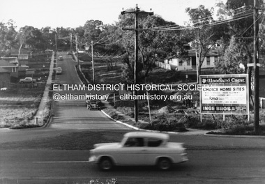 Eltham District Historical Society Inc
Photograph, R.J. Manuell, Woodland Crest, Briar Hill, c.1964
View of Squires land which was subdivided for housing - two parts Woodland Crest higher part off Woodland Grove and Calrossi Avenue, Briar Hill showing new roads with curb and channelling and footpaths. No date. Looking up Hyacinth Avenue, Briar Hill from Sherbourne Road. Hibiscus Avenue first on right then Acacia Court. The white house on Hibiscus Avenue still exists (No. 3)Black and white photograph printed with white bordersVerso: COO2briar hill, real estate, woodland grove, squires, roads, acacia court, hibiscus avenuse, hyacinth avenue, woodland crest estate, inge bros pty ltd -
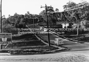 Eltham District Historical Society Inc
Photograph, R.J. Manuell, Sherbourne Rise, Briar Hill, c.1964
Sherbourne Rise Estate, looking up Woodland Grove from Calrossie Avenue, Briar Hill. The house is believed to be No. 8. This is prior to Regal Court being established off Woodland Grove. View of Squires land which was subdivided for housing - two parts Woodland Crest higher part off Woodland Grove and Calrossi Avenue, Briar Hill showing new roads with curb and channelling and footpaths. No date.Black and white photograph printed with white bordersVerso: COO2briar hill, real estate, woodland grove, squires, roads, sherbourne rise estate -
 Bacchus Marsh & District Historical Society
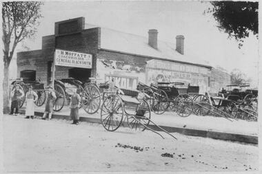
Photograph, H.Moffatt Coachbuilder General Blacksmith Main Street Bacchus Marsh
H. Moffatt, blacksmith, opened new brick premises in 1899 on the site of a similar building burnt down the previous year. He continued to operate as a coachbuilder and blacksmith on this site until 1927 when he retired. Since then, the premises have been used for coffin making, a hardware store, furniture store, bathroom supplies among other things. It is now operating as Lola's Restaurant.Black and white photographic print. Dating from the early 1900s, this photograph is of a substantial brick building opened in 1899 by Mr H. Moffatt at 110 Main Street on the site of a similar building which burnt down in 1898. A sign at the front reads: H.MOFFATT COACHBUILDER GENERAL BLACKSMITH. A number of horse-drawn carriages, two and four-wheeled, stand on the footpath, roadway and on the vacant block next door. The road appears to be unmade and is separated from the elevated footpath by barge boards. Advertising signs line the side wall of the building. Four men stand on the road, three wearing the leather apron worn by blacksmiths, one wearing a long white apron as was often worn by shop assistants. Horse droppings, a common sight in those days, can be seen on the roadway. shops bacchus marsh vic., main street bacchus marsh vic., h. moffatt, coachbuilders, general blacksmiths -
 Kew Historical Society Inc
Photograph - Royal Hotel, Sunbury, C.H.R. Christianson, 1890s
This item is part of a larger collection donated to the Kew Historical Society by Anna French. The collection includes personal items from the donor's family, as well as items given to the donor and her mother by a family friend, Lucy Merritt (Jean) Hornby. The item is from that part of the collection inherited or assembled by Jean Hornby. The collection is significant given Jean Hornby's mother's descent from Robert Hornby (1854-1935) and Eva Merritt (1865-1959); her mother the chid of a family who settled in Kew in the 1850s, this providing a chain of provenance for items dating to the mid-nineteenth century, when her maternal forebears arrived in Melbourne. Other items represent Jean Hornby's contribution to her local and wider community.This 19th century photograph includes significant architectural details of an important hotel in Sunbury, Victoria. Additionally, it was taken by a local photographer - CHR Christianson - who operated the Sunbury [photographic] Studio. Silver albumen print, mounted on board, of the original Royal Hotel on the corner of Brook and Evans Streets, Sunbury, Victoria.The single-storey, rendered brick building with a corrugated galvanised iron roof includes a number of pieces of information that may assist in dating the photograph. The licensee's name above the door appears to be M.A. Williams. To the left of the door on the external wall is a painted sign: 'BILLIARDS". Another painted sign on the front of the building reads "ROYAL HOTEL [illegible] BILLIARDS." An attached building at right may be the residence of the licensee. Specific architectural features of the building include a corner doorway with a lamp above, three sash windows and a larger square lead-light window to the right of the doorway. The latter identifies the space behind as the "BAR". On the footpath in front of this building is a grill set into the footpath to enable deliveries to a cellar. At least four figures can be identified in the photograph: a woman in the doorway, a man to her right, leaning against the wall, and two other men at the right hand side of the building. Beyond the boundary of the building is a sloping footpath to a bluestone edged gutter. An elm [sic] within a protective, picketed surround is in front of the building. C.H.R. Christianson is identified on the reverse as the photographer. Reverse in pencil: Royal Hotel Billards Sunbury / CHR Christianson photographerroyal hotel -- sunbury (vic.), chr christianson -- photographer, hotels -- sunbury (vic.), recreation -- billiards