Showing 560 items
matching land sales.
-
 City of Kingston
Pamphlet - Colour, Farrow Falcon Press, Printers, Ozone Estate, Bluff Road, Hampton, c.1940
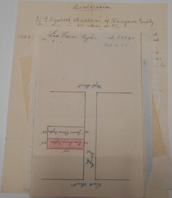
... Land sales...Sales plan for land in the suburb of Hampton (Highett... Parkdale Sales plan for land in the suburb of Hampton (Highett ...Sales plan for land in the suburb of Hampton (Highett), bounded by Bluff Road, Wickham Road, Peterson Street and June Street. Includes Morley Street, Follett Avenue, and Parrett StreetThe developing urban area of Highett within the City of Kingston. This land sale pamphlet illustrates the subdivision of land within the municipality and the changing demographic of the district as new houses are constructed close to infrastructure.Colour pamphlet advertising for private sale the Ozone Estate, Bluff Road Hampton. Incorporates a map of the estate bordered by Bluff Road, Wickham Road, June Street and Peterson Street including Morley Street, Follett Avenue and Parrett Street.Handwritten in grey pencil on reverse: Ozone Printed in purple ink on front top right-hand corner: Vendors are - Leslie Harcourt MacGowan, Esq / Neerim Road, Caulfield / & / Arthur Alfred Parrett, Esq / 311 Flinders Lane / Melbourneland sales, estate, hampton, highett -
 City of Kingston
Pamphlet - Colour, Farrow Falcon Press, Printers, Ozone Estate, Bluff Road, Hampton, c. 1940
... Land sales...Sales plan for land in the suburb of Hampton (Highett... Parkdale Sales plan for land in the suburb of Hampton (Highett ...Sales plan for land in the suburb of Hampton (Highett), bounded by Bluff Road, Wickham Road, Peterson Street and June Street. Includes Morley Street, Follett Avenue, and Parrett StreetThe developing urban area of Highett within the City of Kingston. This land sale pamphlet illustrates the subdivision of land within the municipality and the changing demographic of the district as new houses are constructed close to infrastructure.Colour pamphlet advertising for private sale the Ozone Estate, Bluff Road Hampton. Incorporates a map of the estate bordered by Bluff Road, Wickham Road, June Street and Peterson Street including Morley Street, Follett Avenue and Parrett Street.Handwritten in grey pencil on rear: Ozone Estateland sales, estate, highett, hampton -
 City of Kingston
Pamphlet - Black and white, J. F. Brady, The Hill Estate, Highett, c. 1905
... Land sales...Sales plan for land in the suburb of Highett, bounded... Parkdale Sales plan for land in the suburb of Highett, bounded ...Sales plan for land in the suburb of Highett, bounded by Sandford Street, Turner Street and Point Nepean RoadThe developing urban area of Highett within the City of Kingston. This land sale pamphlet illustrates the subdivision of land within the municipality and the changing demographic of the district as new houses are constructed close to infrastructure.Black and white pamphlet advertising for sale the Hill Estate, Highett. Incorporates a map of the estate bordered by Sandford Street, Turner Street and Point Nepean Road.Handwritten in grey pencil on reverse: The Hillland sales, highett, estate -
 City of Kingston
Pamphlet - Colour, Highett Town, 1888
... Land sales...Sales plan for land in the suburb of Highett, bounded... Parkdale Sales plan for land in the suburb of Highett, bounded ...Sales plan for land in the suburb of Highett, bounded by Highett Road, Worthing Terrace and the railway line, and incorporating Major Street and Train Street.The developing urban area of Highett within the City of Kingston. This land sale pamphlet illustrates the subdivision of land within the municipality and the changing demographic of the district as new houses are constructed close to infrastructure.Colour pamphlet advertising for private sale the Station Entrance Estate, Highett. Incorporates a map of the estate bordered by Wickham Road, Railway Parade, Highett Road and Point Nepean Road.land sales, highett -
 City of Kingston
Pamphlet - Colour, J. F. Brady, Matthiesson's Estate, Highett, c. 1905
... Land sales...Sales plan for land in the suburb of Highett, bounded... Parkdale Sales plan for land in the suburb of Highett, bounded ...Sales plan for land in the suburb of Highett, bounded by Tennyson Street, James Street and Point Nepean Road and including Maher Street, Connors Street, Enright Street, Edward Street, James Street and Matthieson Street.The developing urban area of Highett within the City of Kingston. This land sale pamphlet illustrates the subdivision of land within the municipality and the changing demographic of the district as new houses are constructed close to infrastructure.Colour pamphlet advertising for private sale subdivisions in the Matthiesson's Estate, Highett. Incorporates a map of the estate bordered by Tennyson Street, James Street and Point Nepean Road and including Maher Street, Connors Street, Enright Street, Edward Street, James Street and Matthieson Street.Handwritten in blue pencil: x marked on every subdivision on the map Handwritten in grey pencil at the end of the Price List: x not sold Handwritten in grey pencil adjacent to subdivisions 58, 167 and 166: JP. Turner Handwritten in grey pencil adjacent to subdivision 164: [indecipherable] Markings in grey pencil around the edges of the subdivision map Handwritten in grey pencil on reverse: Matthiesson / Matthiesson Estate / Matthiesson Estateland sales, estate, highett -
 City of Kingston
Pamphlet - Colour, Smith, Nicolson Pty. Ltd, Cheltenham Estate, c. 1890
... Land sales...Sales plan for land in the suburb of Cheltenham, bounded... Parkdale Sales plan for land in the suburb of Cheltenham, bounded ...Sales plan for land in the suburb of Cheltenham, bounded by Point Nepean Road and Swinden Avenue, including Evesham Road and Wallingford Street.The developing urban area of Cheltenham within the City of Kingston. This land sale pamphlet illustrates the subdivision of land within the municipality and the changing demographic of the district as new houses are constructed close to infrastructure.Colour pamphlet advertising for private sale Cheltenham Estate. Incorporates a map of the estate bordered by Point Nepean Road and Swinden Avenue, including Evesham Road, and Wallingford Street.Handwritten in red ink on subdivison 45: D / H Handwritten in red ink on subdivision 46: Anderson Handwritten in red ink on subdivisions 88, 87, 77 and 56: K / D Handwritten in red ink on subdivision 86: D / H Handwritten in red ink on subdivision 63 and 62: Hudson Handwritten in red ink on subdivision 59 [indecipherable] Handwritten in red ink on subdivision 58: aB Handwritten in red ink on subdivision 57: Lavosh Handwritten in grey pencil on subdivision 28, 26, 24, 67, 58, 49: B Handwritten in grey pencil on subdivisions 78 and 79: Paint Handwritten in purple pencil on subdivsion 114 and 86: B land sales, estate, cheltenham -
 City of Kingston
Pamphlet - Colour, Moorabbin News Print, Auction = Sale Heather Grove Estate, c. 1914
... Land sales...Sales plan for land in the suburb of Cheltenham, bounded... Parkdale Sales plan for land in the suburb of Cheltenham, bounded ...Sales plan for land in the suburb of Cheltenham, bounded by Tulip Grove and Heather Grove.The developing urban area of Highett within the City of Kingston. This land sale pamphlet illustrates the subdivision of land within the municipality and the changing demographic of the district as new houses are constructed close to infrastructure.Colour pamphlet advertising auction of Heather Grove Estate, Cheltenham. Incorporates a map of the estate bordered by Wickham Road, Railway Parade, Highett Road and Point Nepean Road.Handwritten in grey pencil on subdivision 1: Sold / 20/- Handwritten in grey pencil on subdivision 2: 25/- Handwritten in grey pencil on subdivision 3: 30/- Handwritten in grey pencil on subdivision 4: 110 / 30/- Handwritten in grey pencil on subdivisions 1, 11, 10, 9 and 8: Sold Handwritten in grey pencil beneath 'Heather Grove': 20/- 20/- 20/- 20/- Handwritten in black ink on subdivison 12 and 7: £85 Handwritten in back ink on subdivision 5: £60 Handwritten in back ink on subdivision 6: £65 Handwritten in grey pencil above subdivision map: 1-8-9-10-11 Handwritten in grey pencil above subdivision map: [enclosed in a circle] 12- / £75 Handwritten in grey pencil above subdivision map: [enclosed in a circle] 2 / £85 Handwritten in grey pencil above subdivision map: [enclosed in a circle] 3 / £100 Handwritten in grey pencil above subdivision map: [enclosed in a circle] 4 / £100 Handwritten in grey pencil above subdivision map: [enclosed in a circle] 5 / £60 Handwritten in grey pencil above subdivision map: [enclosed in a circle] 6 / £65 Handwritten in grey pencil above subdivision map: [enclosed in a circle] 7 / £25- Handwritten in grey pencil above subdivision map: [enclosed in a circle] £125 / [indecipherable] Handwritten in grey pencil above subdivision map: 37.00 / 18.10 / 56.80 / 3 / [horizontal line] / 59 8 Handwritten in grey pencil along railway line marking: 21/6 / 12/6 / 13/- / 19/-land sales, estate, cheltenham -
 Bendigo Historical Society Inc.
Map - BENDIGO PARISH PLAN
... Land sales...BHS Collection BENDIGO Land sales parish map Bendigo Parish ...BHS CollectionBendigo Parish Plan Section Kbendigo, land sales, parish map -
 Bendigo Historical Society Inc.
Document - LANDS OFFICE - CROWN LANDS SURVEYED AND SOLD SANDHURST - 1857 - 1879, 1857 - 1879
... Land sales...PLACE Land sales Lands Office crown land land surveys ...Journal: black hard cover with buff spine and corners. Contains details of crown land surveyed and sold, district of Sandhurst. Double pages numbered on top right, page columns - parish, town lands, particulars, survey fees, date of survey, date of sale, auction, selection price per acre, total amount, purchaser. No index. On spine '08' 'Bendigo A' 26th June 1857 to 1879 (?)Lands Officeplace, land sales, lands office, crown land, land surveys, bendigo, sandhurst -
 Bendigo Historical Society Inc.
Document - LANDS OFFICE - CROWN LANDS SURVEYED AND SOLD SANDHURST, 1860 onwards
... Land sales...Land sales bendigo Lands Office Journal: LANDS OFFICE ...Journal: LANDS OFFICE - CROWN LANDS SURVEYED AND SOLD SANDHURST green hard cover journal with buff spine and corners. Contains details of crown land surveyed and sold in the district of Sandhurst. Indexed in front by parish, alphabetical double pages not numbered. On LH page, parish, town, suburban, country, date of survey. On RH page, date of sale, auction, selection, price, total amount, purchaser. On spine ' index book' 'F' and '09'. Dated from 1860 onwardsLands Officeland sales, bendigo -
 Bendigo Historical Society Inc.
Document - LANDS OFFICE, CROWN LOTS SURVEYED AND SOLD IN THE SANDHURST DISTRICT 1857 - 1905, 1857 - 1914
... Land sales...Land sales Lands Office land surveyed land sold Bendigo ...Document: blue hard cover journal with buff spine and corners. (spine in poor condition, frayed and pieces missing) Contains details of crown lands surveyed and sold in Sandhurst district. LH page: town, suburban or country lands. RH page: auction, selection, price per acre, price overall and purchaser. Indexed by parish inside front cover. On spine ' Index book' ' Lands and Survey' '07' written on spine under damaged spine cover. Dated from 26/6/1857 to 24 February 1914Lands Officeland sales, lands office, land surveyed, land sold, bendigo, sandhurst -
 Bendigo Historical Society Inc.
Document - LANDS OFFICE, CROWN LANDS SURVEYED AND SOLD, 1860/70
... Land sales...Land sales Lands office land surveyed land sold Bendigo ...Document: buff hard cover journal, embossed on borders. On spine 'Lands and Survey' 'Index Book' and '03'. Contains list of parishes in front cover, indexed to page numbers which describes land surveyed and sold in parishes. Double page entries. 230 pages in book. LH page ' town lands, suburban lands, country lands, total lands surveyed, date of survey. RH page: date of sale, by auction, by selection, price per acre, total amount name of purchaser.Lands Officeland sales, lands office, land surveyed, land sold, bendigo, sandhurst -
 Bendigo Historical Society Inc.
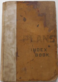
Document - LANDS OFFICE, - INDEX TO CROWN LANDS SURVEYED AND SOLD IN THE DISTRICT OF SANDHURST
... Land sales...Land sales Lands Office land surveyed land sold Bendigo ...Document: Buff hard cover book, with fawn coloured binding on spine (later addition to mend spine?) On front cover drawn in black pen ' PLANS' and 'Index Book' On spine written in black ink ' plans index book'. Contains index of parishes in front of journal with 470 pages indexed to parishes. Double page entries: LH side page: town, suburban or country lands, total lands surveyed. Date of survey. RH page: allotment, section, particulars, no. page. Entries are not dated.Lands Officeland sales, lands office, land surveyed , land sold, bendigo, sandhurst -
![Map, Plan of Town Allotments Bacchus Marsh [1873]](/media/collectors/5e461d8021ea67224c82f2a1/items/677a8ee7ab7bb47995c5573f/item-media/677a8fdeab7bb47995c55b56/item-fit-380x285.jpg) Bacchus Marsh & District Historical Society
Bacchus Marsh & District Historical SocietyMap, Plan of Town Allotments Bacchus Marsh [1873]
... Land Sales Bacchus Marsh... Streets, are also shown on this map. Land Sales Bacchus Marsh ...James Young was a prominent businessman, land owner and public figure in the early colonial period of Bacchus Marsh. After his death in 1871 land remaining from his estate in Bacchus Marsh was sold at auction in 1873. The sale of his estate included the substantial stone residence in Bennett Street which later became known as 'Stone Villa'. The sale of his land in 1873 was conducted by local auctioneer James Crook. 29 allotments were advertised for sale, although the plan for the sale indicated 30 allotments. The sale notice in the Bacchus Marsh Express of 11 October 1873 noted that the allotments were " in the very centre and heart of the most populous and business portion of the township, at the same time being the only remaining portion of the business block available for purchase by public sale, which fact intending purchasers should not lose sight of, as the opportunity cannot occur again". The designation of a new street, 'Bennett Street', shown on the plan, is also indicated in the advertising, "In reference to the main street frontages, opposite the Border Flour Mills. The Auctioneer would also direct attention to the plan, showing the formation of a new thorough fare (Bennett street) leading from Young street into Gell street, thus opening up the township on the high, more healthy, and commanding position so much to be desired for private dwellings".An important cartographic document which indicates an early major subdivision of land in the inner urban area of the Bacchus Marsh township. This subdivision lead to the continuing residential and commercial development of the township of Bacchus Marsh in the later part of the 19th century. The location of two well known demolished public structures, the Free Gardeners Hall in Gell Street, and the Old Mechanics Institute Hall (aka the Buffs Hall), on the corner of Young and Bennett Streets, are also shown on this map.A single page paper map showing 30 blocks of land for sale around 1873 in the vicinity of Bennett Street and Lerderderg Street. Described in contemorary sources as a 'lithographed copy'. No scale is indicated. The map is pasted into a bound volume containing 76 maps or plans in total. High resolution digital image stored on BMDHS computer network. land sales bacchus marsh, bacchus marsh victoria maps, james young 1816-1871, bacchus marsh roads and streets, bennett street bacchus marsh -
![Map, Liquidator's sale, 1896. [Woolpack Estate, Bacchus Marsh]](/media/collectors/5e461d8021ea67224c82f2a1/items/6779ee97032b72846b5995f2/item-media/6779ef33032b72846b599b30/item-fit-380x285.jpg) Bacchus Marsh & District Historical Society
Bacchus Marsh & District Historical SocietyMap, Liquidator's sale, 1896. [Woolpack Estate, Bacchus Marsh]
... Land Sales Bacchus Marsh... also of Bacchus Marsh. Land Sales Bacchus Marsh Bacchus Marsh ...The Woolpack Estate was an area of land owned by various landowners in the Bacchus Marsh area since the early Colonial period of the 1840s. The area was located on the eastern side of the Bacchus Marsh township about 7 kilometers from the town. The Lerderderg River ran through part of the land and so did the Melbourne to Ballarat Road. The historic Woolpack Inn associated with James Crook was also located on this land. By 1896 150 acres of this land was under the control of liquidators for the Federal Bank of Australasia who instructed that the land be sub-divided and sold in lots by public auction. A successful sale was held on 24 June 1896. Most of the blocks of land were sold for higher than expected prices and most of the buyers were people from the town and district of Bacchus Marsh. The map includes various details about the land which is described on the map as an "important sale of rich alluvial irrigable flat land in the Bacchus Marsh Valley, and other properties". The auction was conducted by the local agents W. Anderson and Bence in conjunction with Pearce Brothers also of Bacchus Marsh.A single page paper map showing a plan of 150 acres of land from the Woolpack Estate to be sold in various lots in June 1896. Also shown on the map are lots for sale at Robinson's Farm on Coimadai Creek and allotments near Bacchus Marsh railway station, including lots on Government Road (East Maddingley Road), View Street and Government Road (Parwan Road). No scale provided. The map is pasted into a bound volume containing 76 maps or plans in total. High resolution digital image stored on BMDHS computer network. land sales bacchus marsh, bacchus marsh victoria maps, woolpack estate bacchus marsh victoria -
 Bacchus Marsh & District Historical Society
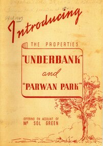
Booklet, Introducing the Properties Underbank and Parwan Park offering on account of Mr Sol Green
... Land Sales Bacchus Marsh... Stud Land Sales Bacchus Marsh Solomon (Sol) Green was a major ...Solomon (Sol) Green was a major bookmaker, businessman, real estate investor, racehorse owner and trainer, and philanthropist. His connection to Bacchus Marsh was through his ownership of the Underbank Stud property which he purchased in 1924. He also owned the Parwan Park property for some time. Both of these properties were put up for sale in 1947 just a year before the death of Sol Green in 1948.Stapled printed softcover booklet. 20 pages. 200mm x 290mm. Facsimile reproduction of a real estate booklet originally produced in 1947 by Sands and McDougall Pty Ltd for sale of the Underbank and Parwan Park properties in Bacchus Marsh. Facsimile reprint of original publication. Date of reprint copy c.2022. Original copy, printed 1947, is also held by Bacchus Marsh and District Historical Society. BMDHS Location: AR/SU4non-fictionSolomon (Sol) Green was a major bookmaker, businessman, real estate investor, racehorse owner and trainer, and philanthropist. His connection to Bacchus Marsh was through his ownership of the Underbank Stud property which he purchased in 1924. He also owned the Parwan Park property for some time. Both of these properties were put up for sale in 1947 just a year before the death of Sol Green in 1948. solomon green 1868-1948, bookmakers, parwan park, underbank stud, land sales bacchus marsh -
 Bacchus Marsh & District Historical Society
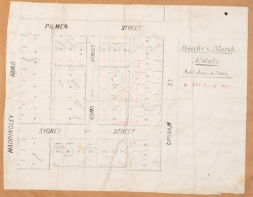
Map, Bacchus Marsh Estate sold 30th June 1888 and sold 28 December 1895
... Land Sales Bacchus Marsh... in 1888 and 1895. Bacchus Marsh Victoria Maps Land Sales Bacchus ...Blocks of land in this area of Bacchus Marsh were sold in lots between 1888 and the late 1890s. This map shows sales made in 1888 and 1895.Single page map showing allotments of land bounded by Pilmer Street, Graham Street, Sydney Street and Maddingley Road (Grant Street) in Bacchus Marsh.The area is dissected by Como Street down the central area. 43 blocks of land are shown with the names of buyers or sellers in 1888 written in black in. Buyers or sellers for December 1895 are written in red ink. Part of a set of maps which are pasted into a bound volume containing 76 maps or plans in total. High resolution digital image stored on BMDHS computer network. bacchus marsh victoria maps, land sales bacchus marsh, pilmer street bacchus marsh, graham street bacchus marsh, sydney street bacchus marsh, como street bacchus marsh, maddingley road bacchus marsh, grant street bacchus marsh -
 Bendigo Historical Society Inc.
Document - RESIDENCE AREAS REGISTER: VOLUME 23, 1935 - 1936
... land sales...residence areas Bendigo Sandhurst land sales Document ...Document: RESIDENCE AREAS REGISTER - Volume 23. Green hard covered book with buff spine and corners. 202 pages, with entries up to page 31. Bendigo District, Sandhurst Division. Dates 1935 - 1936.residence areas, bendigo, sandhurst, land sales -
 Bendigo Historical Society Inc.
Document - RESIDENCE AREAS REGISTER - VOLUME 23 - CORRESPONDENCE, 1935 - 36
... land sales...Bendigo Sandhurst land sales residence areas Document ...Document: correspondence and plans relating to Volume 23 residence areas register. Enclosed inside front cover in plastic pocket.bendigo, sandhurst, land sales, residence areas -
 Bendigo Historical Society Inc.
Document - RESIDENCE AREAS REGISTER - INDEX TO VOLUME 23, 1935 - 1936
... land sales...residence areas Bendigo Sandhurst land sales index Document ...Document: red and grey book, indexed to Volume 23. Dates 1935 - 1936.residence areas, bendigo, sandhurst, land sales, index -
 Bendigo Historical Society Inc.
Document - RESIDENCE AREAS REGISTER: VOLUME 22, 1932 - 1935
... land sales...Bendigo Sandhurst land sales residence areas Document ...Document: RESIDENCE AREAS REGISTER - Volume 2. Green hardcover register with buff spine and corners. 202 pages listing residence areas, Bendigo district, Sandhurst division 3 May 1932 to 6 November 1935. Index contained in separate book. Correspondence enclosed inside book.bendigo, sandhurst, land sales, residence areas -
 Bendigo Historical Society Inc.
Document - RESIDENCE AREAS REGISTER: INDEX TO VOLUME 22, 1932 - 1935
... land sales...Bendigo Sandhurst land sales residence areas index Document ...Document: Index book, blue and buff soft cover. Index to Residence areas register 22.bendigo, sandhurst, land sales, residence areas, index -
 Bendigo Historical Society Inc.
Document - RESIDENCE AREAS REGISTER: CORRESPONDENCE VOLUME 22, 1932 - 1935
... land sales...Bendigo Sandhurst land sales plans residence areas Document ...Document: correspondence and plans relating to Volume 22 residence areas register.bendigo, sandhurst, land sales, plans, residence areas -
 Buninyong Visitor Information Centre
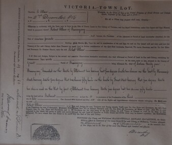
Document - Grant of Land, Victoria - Town Lot Register of Town Purchases 1856 Buninyong, 2 December 1856 (Original)
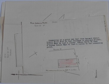
... Land Sales... contribution to Buninyong. Land Sales Robert Allan Buninyong Framed ...Records the details of a purchase of land (Lot 1, Section 34) by Robert Allan in Buninyong in December 1856. Refer to 'Three Times Blest' for details of Robert Allan's contribution to Buninyong.Framed record of land purchase copied from the Register of Town Purchases, No. 59, p. 82. Relates to purchase of land by Robert Allan in Buninyong on 2 December 1856. land sales, robert allan, buninyong -
 Whitehorse Historical Society Inc.
Pamphlet - Advertising brochure, Lucknow Estate, unknown
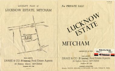
... land sales...90 lots. Agent: Drake & Co land sales lucknow estate ...Brochure advertising sale of Lucknow Estate Mitcham. 90 lots. Agent: Drake & CoBrochure advertising sale of Lucknow Estate Mitcham. 90 lots. Agent: Drake & CoBrochure advertising sale of Lucknow Estate Mitcham. 90 lots. Agent: Drake & Coland sales, lucknow estate, lucknow street, owen street, brian street, ross street, ronald street, lucknow court -
Whitehorse Historical Society Inc.
Pamphlet - Advertising Brochure, The Surrey Estate Mitcham, circa 1948
... land sales...surrey estate land sales mitcham road mitcham rosstrevor ...Brochure detailing plan and prices of Surrey Estate, Mitcham, ca 1948.surrey estate, land sales, mitcham road, mitcham, rosstrevor crescent, alwyn street -
 Bendigo Historical Society Inc.
Document - LANDS OFFICE - INDEX OF CORRESPONDENCE 1964 - 1974, 1964-74
... land sales...PLACE Lands Office Bendigo Sandhurst land sales ...Journal: LANDS OFFICE - INDEX OF CORRESPONDENCE 1964 - 1974 Blue hard cover with red spine and corners. Contains blue lined pages with details of correspondence received/sent. Details include serial number, local number, correspond. Number, name, locality, type, date received, f/book, marking, precis. On spine of book 'ZZ' on white sticker. Written in front page in biro 'walking down the street so fancy free with another guy that could be me'Lands Officeplace, lands office, bendigo, sandhurst, land sales, correspondence -
 Bendigo Historical Society Inc.
Document - RESIDENCE AREAS REGISTER: DOCUMENTS FROM VOLUME 19, 1920-1940
... land sales...land sales residence areas plans Sandhurst Bendigo ...Documents: Collection of drawings, sketches of land allocations (with names) and plans that relate to Residence Areas Register Volume 19.Match page numbers 0f Volume 19 - 11006.1 (Box 56) Covers 1920s to 1930s. Sorted by page number.land sales, residence areas, plans, sandhurst, bendigo -
 Bendigo Historical Society Inc.
Administrative record - LANDS OFFICE: LAND BOARD SCHEDULE 1936 - 1949, 1936 - 1949
... land sales...PLACE land board schedules Bendigo Sandhurst land sales ...Ledger. Hard cover journal, orange-tan cover with leather spine and corners. Contains unused index in front of book. 740 pages with details of local land board dealings, including 'show cause'. On each page: schedule of applications and other matters considered by local land board at (name of area inserted). Some areas listed: Boort, Bendigo, Sea Lake, Robinvale, Swan Hill, Kerang, Kyabram, Castlemaine, Echuca, Daylesford, Manangatang.Lands Officeplace, land board schedules, bendigo, sandhurst, land sales -
 Bendigo Historical Society Inc.
Administrative record - LANDS OFFICE: APPLICATIONS FOR ALLOTMENTS FOR SALE 1869 - 1877, 1869 - 1877
... land sales...PLACE land sales Bendigo Sandhurst Lands Office Ledger ...Ledger. Hard cover journal, green cover with dark red spine and corners. Approx. 500 pages. LH page: date, parish, sec. allot. Area, applicant, address, valuation. RH page: owner of improvements, any other improvement on lot, upset price, remarks. On spine - 'applications for allotments for sale' and 'appn's for sale'.Lands Officeplace, land sales, bendigo, sandhurst