Showing 811 items
matching maps and sections
-
 Bendigo Historical Society Inc.
Map - HUSTLER'S REEF NO 1 MINE - TRANSVERSE SECTION OF THE HUSTLER'S REEF NO 1 MINE
Map of a transverse Section of the Hustler's Reef No 1 Mine on the hustler's Line of Reefs Bulletin No 33, Plate No XXI. Map shows poppet legs at 801.07 feet above Sea Level and drawing of shaft with the different levels. Also shown are geological features and stone encountered. Geological Survey of Victoria emblem H Herman, Director, W Dickson, Secretary of Mines and The Hon. J. Drysdale Brown MLC Minister of Mines. Signed by H S Whitelaw, Underground Survey Office Bendigo, September 1913. This item has not been scanned or photographed.mining, parish map, hustler's reef no 1 mine, hustler's line of reefs, geological survey of victoria, underground survey office bendigo, h s whitelaw, h herman, w dickson, the hon j drysdale brown -
 Warrnambool and District Historical Society Inc.
Map - An Angler's map of the Hopkins River Estuary, Angler's map Hopkins River, 1980s
This is a map of the Hopkins River Estuary prepared by Dr John Sherwood for the benefit of anglers. The information on the sheet includes the location of sand banks, the water depths, boat ramp facilities and public access facilities. Some of the information has been gathered from aerial photographs. The map has been produced by the Warrnambool Institute of Advanced Education which was developed in the late 1960s from the tertiary section of the Warrnambool Technical College and with all its departments established by 1984 at the Sherwood Campus five kilometres from Warrnambool on the Princes Highway. Today the site is occupied by Deakin University, Warrnambool campus. The Warrnambool Anglers’ Club has its headquarters on the banks of the Hopkins River near the mouth of the river and the Lyndoch Aged Care facility.This map is of interest as a specialist one, providing fishermen with detailed information on all aspects of the Hopkins river estuary. Fishing has been both a profession and a popular recreational pursuit for Warrnambool residents since the early days of the city’s settlement. The Hopkins River Estuary has been a focal point for fishermen throughout Warrnambool’s history. This is a sheet of paper folded three times to produce a folded map. The front cover has a black and white photograph of two fishermen with a large fish. The map of the Hopkins River Estuary is in yellow, blue and black and covers the side of one sheet and three quarters of the other side. There is an advertisement for the Hopkins River Boathouse with a black and white sketch of the boathouse and notes on the map written by Dr John Sherwood. There are several diagrams showing the water depths. The map has some silverfish damage and some tearing at the folds. warrnambool anglers’ club, history of warrnambool, hopkins river, hopkins river estuary, john sherwood -
 Bendigo Military Museum
Booklet - A survey of the North Australian Coast on AK121 Aroetta, NT Force, NT Coastal Recce Unit RAE, 6 Aust Army Topo Survey Corps, AKA121 Aroetta, 28 Mar 1945
The work of the Australian Survey Corps is to make maps for the Army. At the outbreak of war very little of the mainland had been mapped, especially the northern parts. The best maps in existence of the N.T. coast in Dec "41 were those made by Matt Flinders in 1801 -1802. The Army soon got out new maps of all important areas including much of the inland. Later it was decided to bring the complete coastline up to date. Several parties put in between them six months on the coast during the dry season of "45 but a couple more months would be needed to complete the program when the "wet" interrupted the work. A small section from Buckingham Bay - Groote Eylandt was still untouched and this diary covers that section of the N.T. Coast. A survey party of four men was chosen who were to be transported from place to place by the AK121 Aroetta - a ketch of 25 tons belonging to an army unit called N.T. Coastal Recce whose work it was to patrol the coast and as well do air - sea rescue. The survey party: Lieut Jack Worsley (the Loot) Sgt Jack Love, Spr Jack Cook, Spr Pat Hede. Crew of Aroetta: Liet Ralph Warne (Skipper), Sgt Buckley (Buck) (First Mate and Orderly Rm), Sgt Jim Terjesen (Jumbo) Bosun, WO2 Tom Davis (Engineer), Cpl Kevin Monk (Artificer), L/Cpl Jack Cox (Deck Hand), Spr Jack Andrews (Signals), Spr Laurie Rament (Ass. Engineer), Spr McKenzie (Mac) (Cook). The complete history is not available after July 31 1945. The remainder of the notes are very badly water-damaged and in some places unreadable.A4 Booklet, plain paper with text and diagrams and half tone photograph of Lt Jack Worsley with plastic binderSigned by George Barton Maj. for LtCol GS. NT Forceroyal australian survey corps, rasvy, fortuna, army survey regiment, army svy regt, asr -
 Bendigo Military Museum
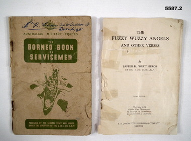
Booklet - BOOKLETS WW2, 2) Sapper H "Bert" Beros NX6925, Fuzzy Wuzzy Angels, The Borneo Book, 1) c.1940's. .2) c.1942
items in the collection re George Lunn VX76842 2/9 Fld Coy, refer Cat No 5581 for his service history..1) The Borneo book for servicemen, card cover 58 pages, maps, photos, contents are in 10 sections re aspects of life/service in Borneo. At rear is 4 pages of hand written notes possibly by a child. .2) Bok Fuzzy Wuzzy Angels and other verses, no covers, 102 pages, contains photos, stories and poetry, held together by 3 staples.booklets, borneo, fuzzy wuzzy -
 Bendigo Military Museum
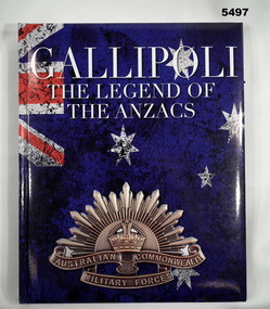
Book - BOOK, GALLIPOLI, HERRON BOOK DISTRIBUTORS PTY LTD, Gallipoli The Legend of the ANZACS, 2016
Hard cover book Hard cover- cardboard with glossy coloured paper finish. White print on illustrated background. Front illustration-colour section of Australian flag and including the Rising Sun Badge . Back illustration- troops in group photograph- sepia tones. 156 pages - glossy paper, white, cut, plain. Illustrated black and white and colour photographs, maps and illustrations.books, gallipoli, anzacs -
 Bacchus Marsh & District Historical Society
Map, Atkins and Clarke Land Sale situate at Bacchus Marsh 1856 Copy 2
This plan of land allotments for sale indicates the property once owned by the Bacchus family in and around the township area of Bacchus Marsh. The Bacchus family sold their property in Bacchus Marsh to John Atkins and Robert Nalder Clarke in March 1851. Atkins and Clarke kept the property for a number of years until April 1856 when these allotments were put up for sale.This plan is almost identical to another copy held by the Bacchus Marsh and District Historical Society, VC Record 707, BMDHS collection). This plan, VC Record 452 Copy 2, contains a less detail than than VC Record 707 Copy 1. For example the selling agents and the surveyor who created the plan are not indicated on this copy of the plan. This copy of the plan does indicate the name Crook Street on the map. As the Crook family were the buyers of the Manor House property and surrounding land from Atkins and Clarke in 1856 it suggests that this copy is a later one of the earlier version. It is unlikely that the Crook family would have had the adjacent street named after them prior to purchasing the house and property. This is a very early land sales plan for the township of Bacchus Marsh and it therefore provides some clues as to how the early urban development of the township took place. Upon seeing the map in 1911 Bacchus Marsh Express newspaper editor Christopher Crisp wrote "The sale appears to have created the present township, which had a nucleus in earlier times further east", Express, 30 September, 1911, page 3. A single page paper map showing a portions of land available for sale in Bacchus Marsh in 1856. The subdivided land shown was owned by John Atkins and Robert Nalder Clarke, but previously owned by the Bacchus Family and was in and around their Manor House (Mansion) property in Bacchus Marsh.There are 5 portions of land further divided into numerous small portions. The land for sale is bounded by the present day streets of Main Street, Young Street, McFarland Street, Morton Streets, Crook Street, and part of the eastern section extends to the Lerderderg River. Scale: 4 chains to 1 inch. The map is pasted into a bound volume containing 76 maps or plans in total. High resolution digital image stored on BMDHS computer network. Plan of the first portion of land. The property of Messers Atkins and Clarke situate at Bacchus Marsh.land sales, land sales bacchus marsh, manor house bacchus marsh, crook family bacchus marsh -
 Bendigo Historical Society Inc.
Map - BENDIGO GOLDFIELD VERTICAL PROJECTIONS
Map of Bendigo Gold Field in two sections showing 'vertical projections along several anticlinal axial planes showing pitch, stratigraphical zones, faultlines, shafts and etc.'. Bulletin No 47 written top left hand side. Lines of reef described: Christmas line Lancashire line Nell Gwynne line New Chum line Hustlers line Garden Gully line Sheepshead line Mines along the reef lines are listed. This map forms part of the Geological Survey of Victoria, Structure of Bendigo Goldfield report, No. 47, 1923. H.Herman, late Director of Geological Survey. On bottom of second section : Prepared in the Geological Survey Office, Bendigo, under the direction of H. Herman, late Director of Geological Survey, from surveys by H.S. Whitelaw, Field Geologist, assisted by E.S. Usher, A.J.J. Moore and R.A. Keble.Geological Survey of Victoriabendigo, gold mining, reef lines -
 Eltham District Historical Society Inc
Document - Folder, Eltham Shire: Guide to historical sources held in the LaTrobe and Reference Library Collections, State Library of Victoria, 1980
Two copies. Folders 68 and 74 from Harry Gilham Collection. "The following work was undertaken at the request of the Shire Planner of the Shire of Eltham to aid in the establishment of a total inforamtion system for the Shire. It is primarily a guide to sources of historical information on the area within the present shire boundaries and also the additional areas which were within the shire's former boundaries". Sources are arranged in the following sections: bibliographies, books and pamphlets, serials, electoral rolls, directories, statistical material, maps, pictorial material and manuscripts.12 pages in a manilla folderWithdrawn copy from Yarra Plenty Regional Librarybibliography, library -
 Ballarat Tramway Museum
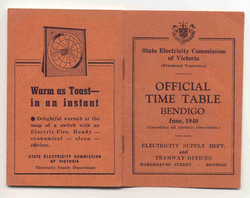
Ephemera - Timetable/s, State Electricity Commission of Victoria (SECV), "Official Time Table Bendigo June 1940", Jun. 1940
Centre pages show a map of the system and the sections. The extension to North Bendigo is yet to be constructed. Gives times for trams leaving the city or the terminals for the routes and for the Eaglehawk route, leaving Long Gully Bridge. Has four SECV Advertisements within the book for hot water, ovens - cookers, toasters and electric fan heaters. Three copies held. See item 5356 for a digital image of the same document with a photograph of Len Smith of Geelong loading a pram into a Birney tram.Provides details of 1940 tram services in Bendigo.Forty-page booklet, with orange lightweight covers, saddle-stapled, SECV Provincial Tramways with the title "Official Time Table Bendigo June 1940". Has address if Hargreaves St Bendigo on bottom of the cover. Two copies held.bendigo, timetables, secv -
Bendigo Historical Society Inc.
Document - CERTIFICATE OF TITLE MCKENZIE STREET
Certificate of title under the transfer of land act 1890. Vol.3219 fol.643627. James Dunlop Boyd medical practitioner and Annie Sophia Boyd married woman, both of McKenzie Street Bendigo areas tenants in common the proprietors of an estate in fee simple, subject to the encumbrances notified hereunder in all this piece of land delineated and colored red on the map in the margin being part of crown allotment fourteen section two B city of Bendigo, together with a right of carriageway over the road colored brown on the said map. Dated the fourteenth day of August 1907.buildings, commercial, mckenzie street -
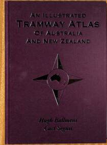 Ballarat Tramway Museum
Book, Hugh Ballment and Carl Segnit, "An Illustrated Tramway Atlas of Australia and New Zealand", 2018
... Maps ...Yields information about the extent and cities that had street tramway systems in Australia and New Zealand and in particular Ballarat.Book - hard cover, 9 sewn sections, full paper bound front covers, 120 pages, gloss paper printed in full colour titled "An Illustrated Tramway Atlas of Australia and New Zealand" with a table of contents by Hugh Ballment and Carl Segnit published by Transit Australia, 2018. Has a preface and acknowledgements, lists 23 Australian and 9 New Zealand cities that had public street tramway systems. Gives maps of the Tramway Museums at the time, trams on public displays and tramway museums that have closed. The Map for the Ballarat Tramway Museum line in Wendouree Parade is not correctly shown.trams, tramways, atlas, australian tramways, ballarat, maps, geelong, bendigo -
 Melbourne Tram Museum
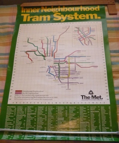
Poster, The Met, "Inner Neighbourhood tram system", mid 1980's
Poster, full colour printed on gloss paper titled "Inner Neighbourhood tram system", giving a diagrammatic Map of the tram system, suburbs, tram route destination names and route numbers and peak service route numbers. Has a separate section for the City area. Shows the routes that ran into the Greensborough and Box Hill Neighbourhoods. At the base of the map has The Met logo and name, a customer service number which has been glued over the printed number. At the base of the poster is a location guide for places of interest, sporting facilities, parks and gardens, railway stations etc.trams, tramways, the met, map, tickets, neighbourhood tickets, tramways -
 Bendigo Historical Society Inc.
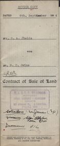
Document - H.A. & S.R. WILKINSON COLLECTION: CONDITION OF SALE
Contract of sale of land dated 6th September 1954 between Mr G.A. Fields (seller) and Mr. B.T. Owins (buyer) for land being part of allotment 7 section L, Long Gully colored red on the map hereof and being described in Indenture of Conveyance No.422 Book 610 and situate in Inglewood Street Bendigo, together with fencing thereon. Price 130 pounds.organization, business, h.a. & s.r wilkinson real estate -
 Melbourne Tram Museum
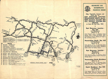
Ephemera - Timetable, Melbourne & Metropolitan Tramways Board (MMTB), East Doncaster Junction, Nunawading North, Jul, 1961
Timetables for specific routes, day of week giving information on tram times at specific time points, route map, sections and fares and organisation address - 616 Little Collins St. Melbourne. 2nd July 1961 1 - East Doncaster Junction, Nunawading North, Blackburn Railway Station, Box Hill Railway Station- Mitcham - Ringwood. 2 - Doncaster Junctioin - Melbourne - route 81 with many supplementary routes - July 1961 3 - Bulleen - City - Garden City routes 15 and 16 - July 1961Demonstrates and early MMTB timetable for bus routes which included extensive details of services.Set of 3 MMTB Bus timetable, folded sheets with maps. Bus routes underlined in blue inktrams, tramways, timetables, tickets, bus services, fares, mmtb, doncaster, ringwood, mitcham, bulleen, garden city, route 15, route 16, route 81 -
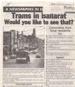 Ballarat Tramway Museum
Newspaper, The Courier Ballarat, "Trams in Ballarat - Would you like to see that?", 19/05/1997 12:00:00 AM
Item in the Education Section of The Courier Ballarat, Monday 19/5/1997 giving a background to the trams in Ballarat and asking a series of questions for students to consider. Information given was comments by local residents for and against, questions, suggested routes, use of horse trams, map and a photo of SEC No. 31 at the junction of Mt. Pleasant and Victoria St. routes. Has newspaper details stapled to the top right hand corner of item.An "X" in the top left hand corner.education, ballarat revival, horse trams, students -
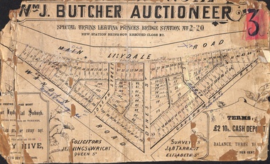 Ringwood and District Historical Society
Poster - Land Sale, Wm J. Butcher, Auctioneer - Albert Park Estate, Ringwood - c.1890
Central section of land sale subdivision advertisement glued to heavy cardboard backing. Photocopied SLV image of original advertisement shows map of 117 allotments for sale in Main Lilydale Road (later Old Lilydale Road), Wandin Road (later Mount Dandenong Road), Joseph Street, Dynes Street, Albert Street (later Wyrunga Street) and Government Road (later Carcoola Road), Ringwood East.Solicitors - Jenningw & Wright, Queen Street. Surveyors - J.&H. Tarrant, Elizabeth Street. Terms £2 10s cash deposit, balance three years at six per cent. -
 Glenelg Shire Council Cultural Collection
Mixed media - Framed Art Work, Wallace, Carmel et al, Lagoon Page 3, 2004
© Anna Lanyon , Carmel Wallace 2004. Apart from any fair dealing for the purposes of private study, research, criticism or review permitted under the Copyright Act, no text, image or part thereof may be reproduced, stored in a retrieval system, or transmitted in any form, without prior written permission from the authors.This suite of etchings explores the natural and social history of Fawthrop Lagoon, an ancient intertidal lagoon that lies at the heart of Portland on the far south-west coast of Victoria, Australia. The work records and interprets essential moments in the life of the lagoon, the plants, birds, insects, water-creatures and humans who have lived and continue to live around its shores. White card backing with white torn looking inner frame. Centre is print of an extract taken from a survey record of the Fawthrop Lagoon Portland listing the name of the reserve, Allotment number, section number, Township, and Municipality. Markings and dates have been written in. Around the outside of the centre image is hand written wording in fine black ink and a map of the town of Portland also in black ink.4/30 Lagoon, Page 3 Carmel Wallacefawthrop lagoon, portland, victoria, australia, plants, birds, insects, water, creatures, humans -
 Bendigo Military Museum
photograph - Cartographic Squadron Production – Army Survey Regiment, Fortuna, c1980
This collection of 12 photos was most likely taken in 1980. The photos were most likely taken in Cartographic Squadron’s Ante Room, the Attic and small offices on the top floor of Fortuna Villa. The computer based Editwriter typesetting system was introduced in 1975 as a replacement to the aging Fotosetter machine. It was operated by a specialised technician, who generated a large variety of map type styles and sizes quickly and reliably, as well as text panels. CPL Richards performed this task for several years and in photo .1P and .2P is reading off a type order next to the computer monitor. Output on Copy proof adhesive backed stripping type film replaced messy wax and spray adhesives in 1978. The Editwriter capability supported all RASvy units and contractor type setting requirements. Scribing was the cartographic process of drafting features such as drainage, relief, vegetation, roads and culture on specially coated map reproduction material. The cartographic technician scribed out the map feature such as a contour to a specified line width on the map sheet, using a tool affixed with a sapphire tipped cutter. The quality control edit (Proving) stage of map production was the first opportunity to inspect a proof of the map independently and systematically. Proving tasks were carried out by technicians conversant of the map product specification and task requirement, however, was not involved in its production. Corrections were identified, marked up and sent to back to the correcting section or contractors. Terrain Embossing was a manual map production technique to produce hill shading on medium to small scale graphics and air charts. SPR John Martin is seen in photos .8P to.10P using a fine embossing metal stylus to push down on the drainage impression on a thin malleable opaque plastic material (AK Poligraphy). Ridge lines were then pushed down using the contour impression as a guide, on the opposing side of the AK Poligraphy to create a 3D plastic model terrain effect. The map impression was sprayed with white paint and photographed to create a contone tone hill shade. SPR Gina (Coore) Neilson is seen in photo .11P washing a contone positive of a land mass in a solution. The contone components were registered to the map sheet, as shown in photo .12P and masked using an air brush and a halftone negative was then created. The terrain embossing method of producing hill shading was more efficient to produce than previous specialised artistic methods such pencil/eraser and air brush. Furthermore, a more consistent enhancement of terrain on charts was achieved between technicians.This is a set of 12 photographs of Cartographic Squadron performing four map production tasks at the Army Survey Regiment, Fortuna, Bendigo c1980. The first ten photographs were on 35mm negative film and were scanned at 96 dpi. Photos .11P and .12P were on photographic paper and scanned at 300 dpi. They are part of the Army Survey Regiment’s Collection. .1) - Photo, black & white, c1980, Editwriter typesetter, CPL Paul Richards. .2) - Photo, black & white, c1980, Editwriter typesetter, CPL Paul Richards. .3) - Photo, black & white, c1980, Scribing contours on a RAAF Chart, SPR Megan (McBurney) Reynolds. .4) - Photo, black & white, c1980, Scribing contours on a RAAF Chart, SPR Megan (McBurney) Reynolds. .5) - Photo, black & white, c1980, Scribing contours on a RAAF Chart, SPR Rod Skidmore. .6) - Photo, black & white, c1980, Scribing contours on a RAAF Chart, SPR Rod Skidmore. .7) - Photo, black & white, c1980, Formal quality control edit (Proving), CPL Ian Belmont. .8) - Photo, black & white, c1980, Hill Shade Terrain Embossing, SPR John Martin. .9) - Photo, black & white, c1980, Hill Shade Terrain Embossing, SPR John Martin. .10) - Photo, black & white, c1980, Hill Shade Terrain Embossing, SPR John Martin. .11) - Photo, black & white, c1980, Hill Shade Terrain Embossing, SPR Gina (Coore) Neilson. .12) - Photo, black & white, c1980, Hill Shade Terrain Embossing, unidentified..1P to .10P No personnel are identified. .11P and .12P annotated ‘Terrain Embossing’royal australian survey corps, rasvy, army survey regiment, army svy regt, fortuna, asr, carto -
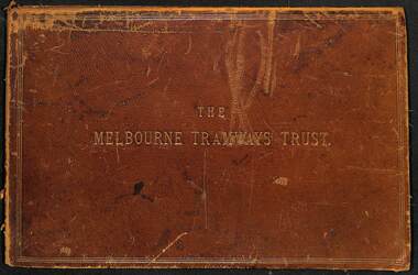 Melbourne Tram Museum
Document - Folder, Kemp & Boyce Printers, "Melbourne Tramways Trust - Cable Tramways", March 1889
... maps ...Plans and documents prepared by George Duncan for the Melbourne Tramways Trust showing details of the track construction, drainage and costs for the construction of the Melbourne cable tram and horse tram system for the Melbourne and Tramway Omnibus Co. Part 1 - track cross sections for both cable and horse trams and various rail weights - lbs/yard part 2 - details costs and mileages for each liine, report from George Duncan and remnant part of a printed map missing the lower half. part 3 - drainage report detailing the works and cost for each line. part 4 - continuation of drainage report - and last part of the book Map printed on cloth - blue print - showing the various lines. Note the Windsor to St Kilda line shown as a horse tram line, but was built as a cable line - the last to be opened.Yields information about the construction of the cable tram system by the Melbourne Tramway TrustFolder - heavy card leather covered covers with gold lines around the edges and gold blocked title. Has marbled glued end papers, containing 9 cloth backed blue print drawings, 22 printed sheets and two foldout maps. The lower half of the first fold out map has been torn out and lost. The second fold out map, a cloth backed blue print.Date stamped in two places with "The Melbourne Tramways Trust Engineers 9 Mar 89" (1889), in two places.tramways, trams, cable trams, mtt, mtoco, melbourne tramway trust, construction, drainage, maps, george duncan, track work, costs -
 Wodonga & District Historical Society Inc
Map - Tulloch & Brown's Map of the Colony of Victoria, Tulloch & Brown, 1856
The map was created by Tulloch and Brown. David Tulloch was one of the earliest engravers and lithographers in the state of Victoria. He arrived in Melbourne from Greenock, Scotland, on 3 January 1849. Following the discovery of gold Tulloch went to the Victorian goldfields in 1851, commissioned to make sketches of the diggers and the diggings for Ham’s Illustrated Australian Magazine. In November 1852 Tulloch set up in business as engraver, draughtsman, copperplate printer and lithographer. Tulloch took a map engraver, James Davie Brown, into partnership in March 1853; the several maps and specimens of commercial engraving they showed at the 1854 Melbourne Exhibition were awarded a bronze medal. That year Tulloch and Brown also received a silver medal at the Victorian Industrial Exhibition. The partnership was dissolved towards the end of 1856.This is a very early map of the Colony of Victoria including Belvoir (now know as Wodonga).A foldable map mounted on linen and with a board cover. It records the Colony of Victoria according to Surveyor's Records revised in 1857. Areas of the map are shaded to highlight different counties.At bottom right hand section of map: Tulloch & Brown's map of the Colony of Victoria : comprising part of New South Wales, the boundaries, counties, also seaport & inland townships, the gold fields with the latest discoveries, roads, tracks, &c. &c. / compiled from drawings in the Survey Office and correctly revised till 1857. Respectfully dedicated by Permission, to the Honorable Captain Andrew Clarke R.E. Surveyor General of Victoria by His Obediant Servants Tulloch & Brown, Engravers & Publishers, Melbourne". At bottom right below border : Published as the Act directs by the Proprietors, Melbourne, 1st Feb. 1856. tulloch and brown maps, rare maps victoria, victorian cartography -
 Warrnambool and District Historical Society Inc.
Documents, Rolf Crawley, Warrnambool, Warrnambool Race Course, 1920s and 30s
These documents deal with improvements in the 1920s and 30s (drainage, painting etc) to the Warrnambool Race Course. In 1854 the Warrnambool Racing Club was established and the first race meeting on the present day Warrnambool Race Course was held in 1858. These documents came from the office of Rolf Crawley, an engineer, architect and surveyor in private practice in Warrnambool and the engineer for the Shire of Warrnambool from 1935 to 1968. His grandfather, father and uncle were also engineers and worked in that capacity or as the Shire Secretary for the Shire of Warrnambool, with the Crawley family recording a total of 132 years of service to the Shire. The Shire of Warrnambool existed from 1863 to 1994. The documents came into the possession of Michael Hand who had taken over the private surveying business of Rolf Crawley in Warrnambool. The Warrnambool and District Historical Society acquired these documents and other Crawley material, from the Michael Hand estate. These documents are of considerable interest as they concern the Warrnambool Race Course improvements in the 1920s and 30s and come from the office of Rolf Crawley of Warrnambool. These are seven documents relating to the Warrnambool Race Course: .1 A manila folder with a handwritten title on the front cover and typed and printed material inside .2 A sketch map of the Warrnambool Race Course produced on heavy quality white paper. .3 Hand-drawn material on the underground drains on the Warrnambool Race Course produced on heavy quality white paper .4 & .5 Longitudinal section of the main drain, Warrnambool Race Course, produced on heavy quality white paper .6 Section of the drain near the fence and culvert of the Warrnambool Race Course produced on heavy quality paper .7 A piece of paper giving the chainage of the Warrnambool Race Course in red handwriting. warrnambool race course, rolf crawley, warrnambool -
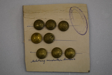 Warrnambool and District Historical Society Inc.
Buttons, Australian Military Buttons, Early 20th Century
The Australian Military Forces buttons were worn by Australian troops in World Wars One and Two. The Australian Commonwealth buttons date from the Edwardian era (1901-1910)These buttons are examples of the buttons used by the Australian Army. The attachment to a card is also an interesting example of the way members of the Warrnambool and District Historical Society mounted and displayed collection items in the 1960's and 1970's.Seven brass circular military buttons pressed into a rectangular piece of cardboard with pasted on lined paper on the back of the cardboard. Three of the buttons feature a raised map of Australia, a crown and text. Five buttons feature a raised intertwined E R,V11, a crown and text Protruding through the paper at the back is a section of a ring. The cardboard side has hand drawn blue lines, an oval stamp with text and hand written text. Three buttons have AUSTRALIAN MILITARY FORCES. Five buttons have AUSTRALIAN COMMONWEALTH FORCES Military medallion buttons ( hand written) Stamp is oval shaped with faded text of which only HISTORICAL DISTRICT and SOCIETY can be deciphered Three blue hand drawn lines to position the buttons. army, australian military forces, buttons, world war two, world war one -
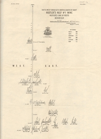 Bendigo Historical Society Inc.
Map - HUSTLER'S REEF NO 1 MINE - EAST & WEST CROSS-CUTS OF THE HUSTLER'S REEF NO 1 MINE
Map showing the East & West Crosscuts, North & South of Shaft of the Hustler's Reef No 1 Mine on the Hustler's Line of Reefs Bulletin No 33, Plate No XXII. Drawing shows where the different levels are, the stone encountered and smaller drawings of other sections near the shaft. Also shows some geographical features. Signed by H A Whitelaw, Underground Survey Office Bendigo, September 1913. Geological Survey of Victoria emblem.mining, parish map, hustler's reef no 1 mine, geological survey of victoria, h a whitelaw, underground survey office bendigo, hustler's line of reefs -
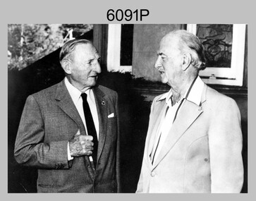 Bendigo Military Museum
Photograph - Army Survey Regiment – CAPT Jack Cullen (Ret), Fortuna, Bendigo, c1978
This is a photograph of CAPT Jack Cullen (Ret) and an unidentified person besides the front steps of Fortuna Villa, Bendigo, c1978. Jack Cullen served for many years in the Royal Australian Survey Corps from 1920 to 1952, after active service with the AIF in WW1. His service at Fortuna began in 1944 when he was a Lieutenant in charge of a map compilation section. Jack Cullen’s service is covered in more detail with additional historic photographs, in Valerie Lovejoy’s book 'Mapmakers of Fortuna – A history of the Army Survey Regiment’ ISBN: 0-646-42120-4This is a photograph of CAPT Jack Cullen (Ret) and an unidentified person at the Army Survey Regiment, Fortuna, Bendigo, c1978. The photograph was printed on photographic paper and is part of the Army Survey Regiment’s Collection. The photograph was scanned at 300 dpi. Photo, black & white, c1988: L to R: CAPT Jack Cullen (Ret), unidentified person‘Jack Cullen’ is annotated on back of the photoroyal australian survey corps, rasvy, army survey regiment, army svy regt, fortuna, asr -
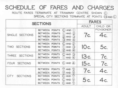 Ballarat Tramway Museum
Poster, State Electricity Commission of Victoria (SECV), "Schedule of Fares and Charges - August 1966", Aug. 1966
... Sections ...Demonstrates an aspect of the SEC method of advising fares and sections to the travelling public. Also gave a small map that would have been useful to crews to explain to visitors where things were. Used in tramcars when trimmed. This poster made for the 1966 or second last fare increase. A similar arrangement used on Bendigo tramcars.Dyeline print of a drawing showing Ballarat Tramway (SEC) Fares, Charges, and Section Map. Also gives charges for Scholar's Monthly tickets, Luggage, Parcels, Newspapers and Chartered trams. Originally dated August 1965, amended August 1966. Note only shows decimal currency. Fares were applicable from 1/9/1966. Titled - "Schedule of Fares and Charges - August 1966" 2nd copy added 1/5/2001 - In good condition and images added as well. 3rd copy added 3-8-2006 - BTPS Cat. No. 608 - folded into four. For map - see blrtfcmap.jpg and for actual fare tables, btm705i1.jpg, btm705i2.jpg"BTPS 608" on outside of folded sheet in black ink and "Ballarat Tramway Preservation Society Catalogue No. 608" on top right hand corner of sheet.trams, tramways, ballarat, fares, sections, map -
Bendigo Historical Society Inc.
Booklet - Frontier Life in the Loddon Protectorate, 1967
95-page light cover booklet of Episodes from Early Days 1837-1842 in the Loddon Aboriginal Protectorate in Victoria. By Edgar Morrison. Map showing the approximate limits of the Protectorate in Victoria on title page. Map of early station boundaries on page iv. Sketch of an Aborigine holding a spear on front cover. Illustrated with B&W photos. B&W photo of Edward Stone Parker (1802-1865) Protector of Aborigines in the Loddon District. A reprint of Parker's Lecture on the Aborigines of Australia, May 10, 1854, is given in a 31-page section at the back. Foreword by Edgar Morrison Feb. 1967. Hugh McColl, Printer, 'Banner' Office, Latrobe StreetHandwritten in ink on front page. 'To Mr A. Chisholm from Alan J. Hardy (?)aborigines, loddon protectorate, edgar morrison, edward stone parker -
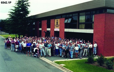 Bendigo Military Museum
Photograph - 4 Fd Svy Sqn Closure Ceremony 25 Nov 1995, 4 Fd Svy Sqn, Keswick Barracks, Adelaide, 25.11.1995
Between 1915 and 1951, military topographical mapping in SA was conducted by Royal Australian Survey Corps (RASvy) units based outside the state. In February 1952, Army HQ Field Survey Section (Central Command Detachment) was established in Adelaide in a drill hall at Largs Bay. It was tasked with providing map coverage in the Woomera and Southern areas of the state. The section was subsequently reorganised as Central Command Field Survey Section moving firstly to Hampstead Barracks, Hampstead in 1953 and then into accommodation at Keswick Barracks in 1954. In 1957 the Section commenced mapping operations in the NT. The Unit was relocated to the old cavalry stables in 1961 and was redesignated Central Command Survey Unit and remained there till 1973. In 1970 the Unit was redesignated 4 Fd Svy Sqn and engaged in operations conducted in PNG from 1972 to 1974 inclusive. In 1973 the Squadron moved into a brand new two-storey specially designed and purpose built building adjacent to the old building. The old building then became the Squadron Q and Map store with an interconnecting lobby to the new building. Since 1975 the Unit was involved in the 1:50,000 Mapping Programme in WA, NT, QLD, SA and conducted many other operations within Australia and overseas. Post disbandment of the Corps the old Squadron building (cavalry stables) now houses the Army Museum of South Australia (AMOSA). The Royal Australian Survey Corps was amalgimated into the Royal Australian Engineer Corps in July 1996. In the lead up to this amalgamation, 4 Field Survey Squadron Keswick Barracks, Adelaide, South Australia was disbanded in 1995. A closing Ceremony was held on 25 November 1995 at 4 Fd Svy Sqn Keswick Barracks attended by about 208 former members of the Unit. A photo was taken of attendees at that event on the day and a list was prepared of attendees. All attendees were sent a copy of the photograph and the list of names as a momento of the Unit and the ceremony..1P A4 Print of an original photo of attendees at the 4 Fd Survey Sqn Closure Ceremony at Keswick Barracks 25 Nov 1995. .2P A4 Print of the names of the attendees at the 4 Fd Survey Sqn Closure Ceremony at Keswick Barracks 25 Nov 1995. Approx 208 attendees.royal australian survey corps, rasvy, fortuna, army survey regiment, army svy regt, asr, 4 fd svy sqn -
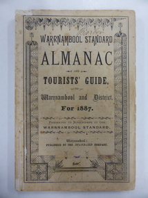 Warrnambool and District Historical Society Inc.
Book, Warrnambool Standard Almanac 1887, 1887
This booklet was given to subscribers to the Warrnambool Standard newspaper as an almanac for the year 1887. These Standard almanacs were produced from 1875 to 1930. They contain much local information on Warrnambool and district about the businesses, government officials, schools, societies and organizations, harbour management, churches, banks etc. The Warrnambool Standard newspaper was established in 1872 and continues to this day. This booklet is of high significance as it contains much valuable information on Warrnambool and district for the year 1887. It is a very important research tool for those studying and writing the history of Warrnambool and district. This copy has the name ‘Barber’ on the front cover and probably refers to George Barber, the son of George Barber, a well-known solicitor who opened a legal practice in Warrnambool in 1855. He died in 1879 and it appears that a member or members of his family went to live in the Maryborough district. This copy came into the collection of the Warrnambool and District Historical Society via the Midlands Historical Society. This is a soft cover booklet of 73 pages, plus several pages of advertisements. The section on the tourist’s guide to Warrnambool is printed in pink. There is a fold-out page with a map of the railway routes in Victoria. The cover is buff-coloured with black lettering and is slightly frayed. There is some scribble on the first page and the back cover. There are many black and white illustrations and several sketches of Warrnambool and district printed in pink. The name ‘Barber’ is handwritten in black ink on the front cover. ‘Barber’ ‘Miss Duff c/o Mrs Hyslop Farquar Lodge Lysle Street Ladysmith South Africa’warrnambool standard newspaper, history of warrnambool, standard almanac1887 -
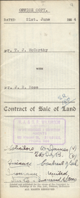 Bendigo Historical Society Inc.
Document - H.A. & S.R. WILKINSON COLLECTION: CONTRACT OF SALE
Contract of sale of land dated 21st June, 1954 between Mr. T.J. McCarthy (seller) and Mr. J.R. Rose (buyer) for land part of Crown allotment 13 section 97C being the land delineated and coloured red and blue on the map in the margin of certificate of title volume 6325 folio 837 and situate No.450 Hargreaves Street, Bendigo. Together with 7-roomed brick dwelling and all sundry. Price 2.500 poundsorganization, business, h.a. & s.r wilkinson real estate -
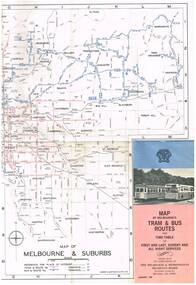 Melbourne Tram Museum
Map, Melbourne & Metropolitan Tramways Board (MMTB), "Map of Melbourne's Tram and Bus Routes" - January 1967, Jan. 1967
Fold out map (12 sections), coloured of Melbourne's Tram and Bus routes, route numbers, rail lines, and location of major places of interest. On rear index to routes, 1st and last services, time of Sunday am services, list of suburbs, how to get there, MMTB Offices and depots and timetable list of all-night buses services.. Dated January 1967. Two copies held. 3rd copy added 28/5/15trams, tramways, melbourne, map, tram & bus services, all night services, route numbers, mmtb