Showing 453 items matching " railway lines "
-
 Otway Districts Historical Society
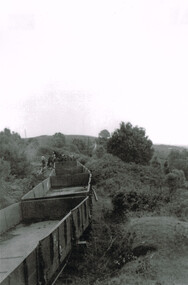
Photograph, Les Ogden, Out of Crowes, 1961, 1961
On 8 March 1962, after the line from Crowes to Weeaproinah was shut down. Beginning at Crowes, groups of gangers started removing the tracks, loading them into NQR open wagons pushed by locomotive G42.B/W. Four empty NQR open wagons with a group of gangers tearing up the lines.crowes; beech forest; weeaproinah; railways; -
 Otway Districts Historical Society
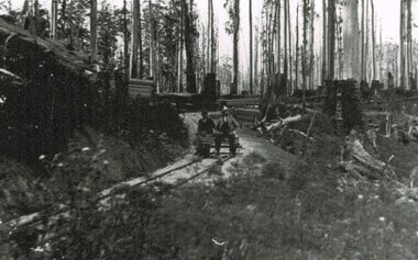
Photograph, Wimba: Inspecting officers, 1902, 1902
B/W. Two inspecting officers examining newly built lines near Wimba in 1902.wimba; railways; beech forest; colac; -
 Otway Districts Historical Society
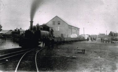
Photograph, Locomotive 8A and its mixed train at Colac Railway Station, c.1920, c.1920
Station facilities for the travelling public on the narrow gauge line at Colac Railway Station were non-existent for many years. Tickets were purchased from the broad gauge booking office and the travellers then had to walk with their luggage over the rough, potentially ankle-twisting, stone approaches, through the goods yard and wait in the open amongst the mud holes alongside the narrow gauge departure track. In 1922 a footbridge was erected over the broad gauge lines, and a passenger shelter and small goods shed were built on the departure track.B/W. At Colac Railway Station, an locomotive 8A with five NQR wagons, an NM livestock wagon and a NBDBD combined passenger and brake van destined for Beech Forest, with either the driver or the fireman peering out of the engine, three youths standing at the front of the engine, and a group of people, including a woman, standing near the livestock wagon. A multi-storied shed and two houses are in the background. 179mm x 280mm picture.colac; railway; narrow gauge; na locomotive; -
 Otway Districts Historical Society
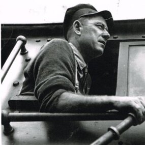
Photograph, Kevin L Holmes, Driver Bill Brady with Train Staff, 1961, 1961
Railway systems have methods by which trains can proceed in safety from station to station, free from the risk of collision with other trains. These methods are generally known as "Safeworking" and they particularly apply to trains on single lines where trains run in opposite directions. The stations between these two sections are called crossing stations. A "Train Staff", a thick, round metal rod, bearing the name of the two stations is issued and these places are designated as Train Staff stations. No train is permitted to proceed through the section unless the train driver either takes the staff for the section into his possession or personally sights the staff. (Note that every station on the line is not a crossing station. These roles were performed at Barongarook, Gellibrand, Banool, Beech Forest, Wyelangta, Weeaproinah and Crowes.) Except for the period 1927-1939 when Train Section Orders were applied instead, due to declining business Train Staff and Ticket working was used throughout on the line.B/W. Driver Bill Brady holding the Train Staff in the cabin of Garratt locomotive G42, at Weeaproinah 1961 railways, bill brady, train driver, weeaproinah, train staff -
 Otway Districts Historical Society
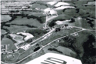
Photograph, R. Preston, Aerial view: Beech Forest, 1965, 13 February 1965
B/W. Aerial view of Beech Forest showing the complete station yard including the balloon loop (incorporating the two tennis courts), two ex-departmental residences, the station building and where the Colac and Crowes lines diverged. As well Beech Forest Hall, council offices and Shire Secretary's house, Denherts Track, and Main Road are shown.beech forest; railways; township; aerial; -
 Otway Districts Historical Society
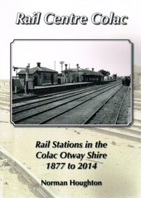
Book, Norman Houghton, Rail Centre Colac, 2014
Colac was the centre of a spidery rail network over which were carted anything and everything by Victorian Railways, the common carrier throughout the area. The main line through the region was the 35 km rail route from Birregurra (and thence to Geelong) though Colac to Pirron Yallock (and thence to Warrnambool and Port Fairy) from March, 1877, to July, 1883. The first branch line ran from Irrewarra to Beeac in 1889, which then extended in stages to Cressy and on the Ballarat. The second branch line was the 31 km long Birregurra to Forrest in 1891. The cost of building railways into mountainous terrain meant the third branch line was a narrow-gauge 2 foot 6 inch line, first of all to Beech Forest in 1902, and then to Crowes in 1911, for a total of 71 km. The final rail connection was the 16 km branch from Colac to Alvie to facilitate the transport of onions, opening in 1923. Each line had its own character and peculiarities derived from its foundation, geography and economic base. As a general rule, the loadings on the branch lines had greater output tonnage than inwards, the reverse of the main line. The lines traversed agricultural and timber areas where inputs like seed, grass, fertiliser and labour were minor, compared with the output, timber, wool, cream, butter, cheese fruit, potatoes, onion, grain and livestock.Rail Centre Colac. Rail stations in the Colac Otway Shire, 1877 to 2014. Norman Houghton. 1st ed. Norman Houghton; Geelong (Vic); 2014. vi, 262 p.; illus., maps, index. Soft cover.colac; cressy; forrest; beech forest; crowes -
 Otway Districts Historical Society
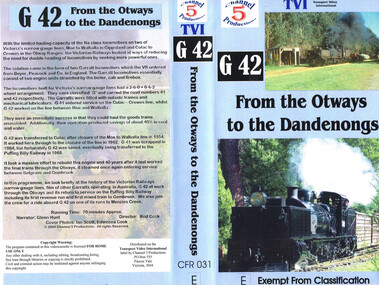
VHS Video, Channel 5 Productions, G42 From the Otways to Dandenongs, 2004
Shows footage of G42 at work in the Otways.Brief history of Australian narrow gauge lines including G42. Film of G42 at work through the Otways.g41 narrow guage railway -
 Bendigo Historical Society Inc.
Slide - Images by Arthur Pulfer, 1957-1970
ROSEVIEW 407 High Street, Golden Square Bendigo "Roseview" was designed by Godfrey Eathorne and constructed in 1939. It is one of the few Streamline Moderne houses in the Central Goldfields region, and was one of the earliest constructed in the Bendigo region. It is an outstanding example of this style of housing. It resembles an ocean liner, and reflects the emphasis on the streamlining of methods of transportation. It utilizes both flat and curved surfaces and has little external ornamentation. The use of materials such as rounded glass windows and metal window and door frames reflects an innovative approach to construction consistent with the style. "Roseview" was constructed on a large scale, with large and spacious rooms. It reflects the prominent social status and wealth of the original owner, together with the desire for a building in 'the latest' style which was sure to attract attention and prominence in the region. It has been maintained largely in original condition. CARALULUP HOTEL 'The Sun' dated January 17, 1941 on the back. It states that 'The licence of Caralulup Hotel, near Talbot, has been surrendered, thus severing an 80 year association with the district' State Library of Victoria TOLMER GOLD ESCORT ROUTE The gold rush in New South Wales and Victoria left few able miners in South Australia. Bad economic conditions saw more than 15,000 men leave the Kapunda and Burra mines by the end of 1851. Alexander Tolmer, Commissioner of Police in 1852 proposed that the gold won by South Australians should be brought back to South Australia under an escort consisting of only a few men. In March a Gold Escort was on its way back to Adelaide with almost 6,000 ounces of gold for the vaults of the Treasury Building. After this successful trip Tolmer led two other escorts before handing over his duties. A total of eighteen gold escorts were made, the last one during November and December 1853 when Inspector Wyndham was in charge. You’ll find Gold Escort Route Monuments between Meningie, Coonalpyn and Tintinara.Many images from by Arthur Pulfer copied to slides. Twenty Slides of Bendigo: Bullen's Circus Bendigo February 1966 "Roseview", Pethard's Home at 407 High Street, Golden Square, Bendigo. 25th March 1957. House is possibly on the Midland Highway Epsom, Bendigo - 8 April 1955 Kangaroo Flat Bus Lines mini bus The Big Tree Sedgwick Road March 1972 The old Golden Gully Hotel Diamond Hill Road, Bendigo The old Lockup Eaglehawk Bendigo September 1967 Market Gardens - possibly North Bendigo North Deborah Mine photo taken from Breen Street 1958 Laying the track to get the engine into the park, looking down Mitchell Street Bendigo Engine R766 in the Victorian Railways Institute Park Railway Place Bendigo On the Methodist Church Steps Arnold street Bendigo Miner's Hut at Moliagul Basket Lunch - White Hills Botanical Gardens - St johns 100 year celebrations White Hills Swimming Pool February 1970 White Hills Botanical Gardens Bendigo Bendigo Show Parade 1958 The Arrival of the Cobb and Co Coach in Bendigo September 1963 history, bendigo, james lerk collection, golden square high school, dragon loong, white hill botanical gardens, 407 high street bendigo, r766 engine, bullens circus, caralulup, moligual, bendigo show, tolmer's gold route, kangaroo flat bus lines, eaglehawk lockup, arnold street methodist church, elephants -
 Bendigo Historical Society Inc.
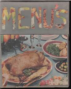
Document - LYDIA CHANCELLOR COLLECTION: MENUS
A box containing menus. (1) Shipping and railway menus and passenger lists 1913 - 1955. (11) Breakfast menu Bendigonia Motel. (111) Shamrock Hotel Centenary dinner menu 11th April 1956. (1V) Moomba Festival program March 1955. ( 1V) An Orient Line letter card addressed to Mrs. G.A. Pethard.photos of RMS Orford (V) Bendigo 'Advertiser' article dated 9/5/1964 and titled, three pages for Women' and 'Womens World' conducted by 'Toora.' It describes a Mayoral Ball of 1910 ('a flashback!) and also included are some photos of local Bendigo women. Dated 1910 - 1964. // White Star line Passenger information booklet-painting of RMS Ceramic 18,494 Tons on the back page .The booklet relates to the Steamer Suevic 12,686 tons sailing from Liverpool 27.9.1924 /// Passenger list for Canadian Pacific Railways Company Royal mail Steamship Empress of Ireland -Second cabin Passenger List sailing from Liverpool to Quebec 5.9.1913// SS Suevic plan of passenger Accommodation.The Advertiser, Bendigonia Hotel, The Shamrock Hotel, Womens World.person, individual, lydia chancellor, lydia chancellor, collection, menus, food, shipping, ships, travel, tourism, shipping lines, passenger lists, 'toora, ' the 'bendigo advertiser, ' correspondence, orient line r.m.s.''orford, '' bendigo mayoral ball 1910, mrs. hedley jones, mrs. j. lang, mrs. f. harris, mrs. a.s. craig, mrs. g.r. short -
 Ballarat Tramway Museum
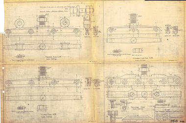
Drawing, Victorian Railways (VR), Ears for Tramway Overhead Construction, 1924
... fabricated for use on the two tram lines, or electric street railways ...Gives the design details of the device or fitting known as a trolley wire ears that holds a tramway copper trolley wire in position. Notes that the drawing was traced in 1924 from a MMTB drawing. Has details for a splicing ear, straight line ear. feeder ear and curve ear along with details for nuts and screws.Yields information about the design of four different types of trolley wire fittings and how they were fabricated for use on the two tram lines, or electric street railways operated by the Victorian Railways.Dyeline print of Victorian Railways drawing number 4057 - Ears for Tramway Overhead ConstructionHas number "7513 D.33" in black pen in bottom right hand corner.tramways, trams, overhead, victorian railways, trolley wire, engineering, electrical engineering -
 Ballarat Tramway Museum
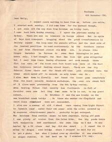
Letter - from Alwyn Marshall Toolamba to Wal Jack, Alwyn Marshall, 1958 & 1959
Wal Jack had an extensive range of correspondents throughout Australia and the world. This set are two letters from Alwyn Marshall of Toolamba, who travelled extensively. His first letter discusses tramways in Sydney, the type of trams in use, Brisbane tramways, NSW Railways on the Sydney to Brisbane line, Queensland railways, the Sandy Hollow line and the wooden trestle bridge near Nayook. He used a motor bike for his Australian travels. The second letter discusses the Frankford lines in Philadelphia and sending maps of the system.Demonstrates some of the correspondence that Wal Jack received from around the world.Set of two typed letters on quarto paper from Alwyn Marshall to Wal Jack 4 Dec 1958 - two sheets Friday, May 1 (no year), single sheet - based on the calendar most likely 1959) letters, wal jack, railways, photography, tramways, sydney, brisbane, qgr, nswgr, philadelphia, alwyn marshall -
 Ballarat Tramway Museum
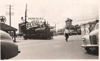
Photograph - QGR locomotive at Woolloongabba Brisbane, Keith Kings, 10/1/1951
Wal Jack swapped photographs with his correspondents. This photo by Keith Kings, a railway photograph of QGR locomotive 748 crossing the complex arrangements of tracks at Woolloongabba - three tram tracks, one trolley bus route. The photographer noted that trains could block all tram lines at times. Trains were always proceeded by a man carrying a red flag and ringing a bell. Has the tramway signal box in the background and a large Penfolds Wines advert on a building, a Caltex service station and an advert for Plume petrol.Demonstrates a photograph that would have been sent to Wal Jack by Keith Kings.Black and white photograph of QGR locomotive 748Has extensive details of the photograph on the rear. Keith Kings photo number E(k)(vii)letter, wal jack, keith kings, qgr, railways, woolloongabba -
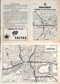 Ballarat Tramway Museum
Map, RACV - Royal Automobile Club of Victoria, "Ballarat including city and district maps", 10/1961
Shows the central part of Ballarat, Ballarat Outlets, streets, principal attractions, Ballarat and district maps and information. Has the tram lines shown dotted, does not run out to Sebastopol or the Lydiard St North terminus. Each map in the bottom left-hand corner has the number "1061", possibly indicating the date. Has notes on the City, points of interest, and an advertisement for Caltex. See item 4929 for a larger version dated 1966. Yields information about the extent of Ballarat in the early 1960's shows the tram lines and other rail lines in the district. Four fold map printed on white paper, titled "Ballarat including city and district maps" - Map No. MAP 15.314 and dated 10-61. Produced by the RACVmap, tranways, ballarat, racv, railways -
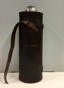 Kew Historical Society Inc
Container - Erica Lines Thermos Flask, 1900-1950
Erica is a town in Victoria, in the Shire of Baw Baw. In the early 1900s, the township of Erica began to grow after construction of the railway line from Moe to Walhalla. When the station opened in 1910 it was named Harris, but was renamed Erica in 1914. Erica was to become the largest town on the Moe-Walhalla railway. The railway line from Moe to Erica closed in 1954. When the item was donated by Raif Brunette in 2007 it was described as a 'Stagecoach thermos flask with leather protective cover'.Metal thermos flask encased in a leather cover embossed with the name 'Erica Lines'."ERICA LINES"erica lines, thermos flasks -
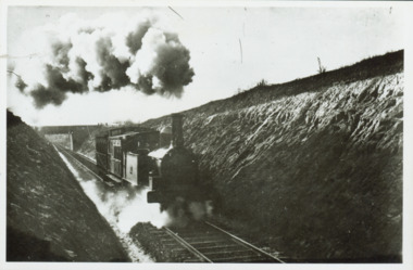 Kew Historical Society Inc
Photograph - Train coming up grade beyond Barnsbury Rd, Deepdene 1905
... Pakenham and Cranbourne lines. trains outer circle railway Steam ...The Outer Circle Railway was opened in stages in 1890 and 1891, as a steam-era suburban railway line. It traversed much of the modern City of Boroondara, including the suburbs of (from north to south) Kew East, Camberwell, Burwood, Ashburton, and Malvern East. At its longest, it ran from Fairfield station, on what is today the Hurstbridge line, to Oakleigh station, on the current Pakenham and Cranbourne lines.Steam train in a cutting on the Outer Circle Railway line. Exhibition enlargement donated by Stewart West from an original owned by Miss Foley.trains, outer circle railway -
 Kew Historical Society Inc
Map, MMBW, MMBW Plan No.67 Kew, 1900-1910
The Melbourne and Metropolitan Board of Works (MMBW) was established by an act of the Victorian Parliament in 1890 to prepare for and to implement a sewerage and water reticulation system across what was then inner Melbourne, its surrounding and middle distance suburbs, including Kew. The MMBW was disbanded in 1991.The map collection of the Kew Historical Society has at its core the historic maps assembled and originally stored in the City Engineer's Department of the City of Kew. These include maps in a number of scales. The vast majority of maps were produced by the MMBW in the first two decades of the twentieth century, and are solid working maps, backed by linen for durability. These maps are historically significant to Kew, the City of Boroondara and to the history of the development of state utilities in Victoria. A number of the Kew maps have additional details added by former municipal officers, including the levels reached by various floods. As these were working documents, information was added to them long after the period of their initial production and distribution.Early map of part of the Borough of Kew, created in the first decade of the twentieth century, at a scale 160 ft to 1 inch. The map covers what was then the north central part of Kew, bordered on its north by the Outer Circle Railway Spruzen and Beresford Avenues, in the west by Princess Street, in the south by High Street, and in the east by (about) Belford Road. The map shows the extent of urban development by that time, prominent institutions and the outlines of built structures in the municipality. Contour lines were added in ink to the map at a later stage.MELBOURNE AND METROPOLITAN BOARD OF WORKS / PLAN NO. 67 / KEW melbourne & metropolitan board of works, mmbw maps, mmbw plans, borough of kew, cartography -
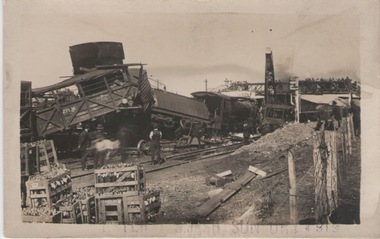 Sunbury Family History and Heritage Society Inc.
Photograph, Railway smash, 17 April 1919
The photograph has recorded rail smash which occurred at Sunbury on 17th April 1919 when a stock train crashed into a goods train. It caused a lot of damage to the rolling stock and blocked rail traffic on the Bendigo and Maryborough lines. The driver and the firemen of the stock train were injured.This accident is only one of a number which have happened on the Sunbury Bendigo rail track over the years.A black and white photograph with a white border in postcard format of a rail accident where some of the carriages are on their side and workman are in the railway yard inspecting the damage.sunbury, rail accidents -
 Sunbury Family History and Heritage Society Inc.
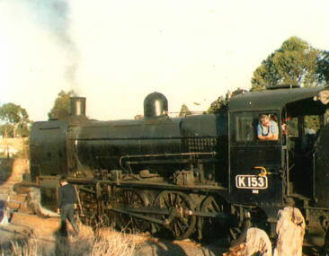
Photograph, c 1970s
The K class steam engines were often used on Victoria's regional rail lines taking passengers and goods across the state. A coloured photograph of a stationary steam train on railway tracks with the driver looking out his cabin window and a man walking alongside the train. steam engines -
 Sunbury Family History and Heritage Society Inc.
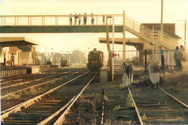
Photograph, c
The steam train has arrived at Number 2 platform at Sunbury Railway Station. Before diesel engines were used on the regional lines, steam trains were widely used. The pedestrian bridge spanning the railway line was replaced with a larger one to allow for disabled people's in 2001.A coloured photograph of a steam train arriving at a station with six people on the pedestrian bridge looking at the train and five other bystanders on the two platforms.steam locomotives -
 Stawell Historical Society Inc
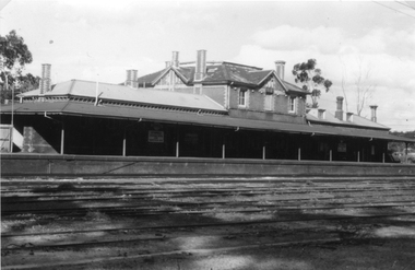
Photograph, Railway Station Stawell
Railway Station Stawell. B/W photo showing large two storey brick station with long verandah over platform in heavy shade. Rail lines in foreground. This Photograph is a copy of a Negative owned by the Society - paid from a grant 1991. This Photograph is of Stawell Railway Station.B/W. Photograph of Stawell Railway Station taken from acroos the railway tracks. Also showing two vechiles of the far right. the centre of the building is two story stawell railways, transport, mark dadswell -
 Surrey Hills Historical Society Collection
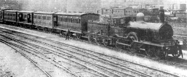
Photograph, The 'Crack Express' 204
This photo originally appeared in the Canterbury Courier in an article by Dave Staig. This type of train was used on all the rail lines in 1883 - the date when the railway came through to Surrey Hills. it is thought that the photo was taken in the Spencer Street yards. There is a copy of the article in this collection. Black and white photo of a steam train with more than four carriages. It was taken in an unidentified railway yard. railways, canterbury courier, public transport, david staig, crack express, dave staig -
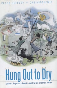 Surrey Hills Historical Society Collection
Book, Hung out to dry: Gilbert Toyne's classic Australian clothes hoist, 2009
Archibald McKirdy purchased the Toyne's hoist business in 1925 and moved its production from Carnegie to Mont Albert where the family had lived since the 1880s. The factory was in Mont Albert Road near the railway line and the family lived at 2 Stanhope Street. 'Hung Out to Dry' is based on detailed and innovative research and analysis; part family history, part social history, part industrial history, part garden history. It is the story of the rotary clothes hoist.'Hung Out to Dry' is based on detailed and innovative research research and analysis; part family history, part social history, part industrial history, part garden history. It is the story of the rotary clothes hoist.(mr) gilbert toyne, inventors, (mr) archibald mckirdy, clothes lines, (mr) peter cuffley, cas middlemis -
 Port Fairy Historical Society Museum and Archives
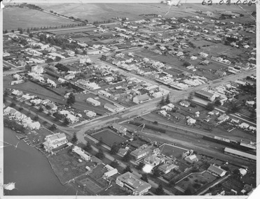
Photograph, 1940's
This photograph shows Port Fairy from the air looking down on Douglas House across the rail lines showing Bank Street, Sackville Street, Cox street and to a lesser extent surrounding streetsThis photograph depicts the Streets and river during the 1940's and the buildings that were present at that time some no longer in existenceBlack and white PhotographALEX WILKINS PHOTOGRAPHER WARRNAMBOOL O.G.Powell Chemist Phone 88 Port Fairybank street, sackville street, railway -
 Melton City Libraries
Photograph, Melton Railway Bridge, c.1884
"The Melton Viaduct, opened in 1886, is of State heritage significance as a very large and visually distinctive wrought iron, lattice girder trestle bridge over the Werribee River (now Melton Reservoir). It comprises 18.3 and 9.1 metre spans, in a generally alternate arrangement, of total length 375 metres, and standing 38 metres over the Werribee River. Wrought iron small section iron was used to build tension trussed trestle legs, which supported four lines of rivetted wrought-iron deck-type double lattice trusses. It has bluestone abutments and pier bases of coursed rock-faced bluestone with drafted margins. The larger half-piers, now usually submerged in the Melton Reservoir have sharp tapered cutwaters and curved coping at the tops. While designed to carry two rail tracks it has only ever been used as a single track line. Despite several alterations to its deck structure, it remains an outstanding example of a lighter structural design employing open metal trestle supports and metal truss girders. The direct Melbourne to Ballarat railway link of which the Melton viaduct was the major engineering work contributed significantly to the history and development of Victoria. This new link reflected Ballarat’s diversifying economy as well as the commercial and political influence of the metropolis. Construction of the bridge, and the associated large workers camp, were extensively photographed, documenting an important episode in local history. The railway enabled the development of new industries in the Melton area, notably the timber industry and a chaff industry of national importance, greatly facilitated the later transition of the Shire from a pastoral to a farming economy, and struck a major blow to Melton township’s era as a wayside town servicing Ballarat road (especially coach) traffic". Melton Railway Bridge being built across the Werribee Rivertransport -
 The 5th/6th Battalion Royal Victoria Regiment Historical Collection
Map, Britain and Underground Railways, July 1919
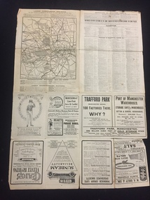
... along the fold lines. Britain and Underground Railways Map Map ...Used by Australian Soldiers whilst on leave after WW1.Reversible map made of paper. One side has a map of Britain and Ireland printed in colour, the other has a map of the London underground as well as several advertisements. there are small tears along the fold lines.wark vc club, regiment property -
 Wodonga & District Historical Society Inc
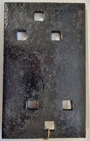
Functional object - Rail fish plate from Cudgewa Line, 1930 - 1960s
Cudgewa Line -The Cudgewa railway line opened in stages between 1889 and 1921. The first section from Wodonga to Huon opened on 10 September 1889. It was extended to Bolga on 18 July 1890, Tallangatta on 24 July 1891, Shelley on 13 June 1916 (the highest station in Victoria), Beetomba on 10 April 1919 and Cudgewa on 5 May 1921. The line had 1 in 30 grades and trestle bridges that have been heritage listed. In 1919, the line was used to carry materials for the construction of Hume Weir, and three years later a spur line connecting Ebden to the weir was opened. In the 1960s, Cudgewa became the railhead of materials for the Snowy Mountains Scheme. The last passenger service from Wodonga to Tallangatta ran on 30 September 1961. The turntable and passenger platform at Cudgewa were abolished in 1976. This fish plate came from the rails of the Cudgewa Line at Gordon Roy's hut which was situated behind Perry's Stump Hotel outside Wodonga. The hut was used as an office with the points lever outside to switch trucks to different tracks on the Bandiana and Cudgewa lines.This item is significant as it was part of the railway line to Cudgewa which played an important role in North east Victoria carrying freight during the construction of the Hume Weir and the Snowy Mountains Scheme.A section of flat plate. These plates were used in pairs to connect the ends of adjacent rails in railway track. victorian railways, cudgewa rail line, railway components -
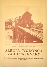 Wodonga & District Historical Society Inc
Programme - Albury-Wodonga Rail Centenary Celebrations, VicRail Public Relations Division, 1983
This item was written for the celebration of the centenary of the linking by rail of Victoria and New South Wales systems on June 14, 1883. It gives a brief history of the stages and stories surrounding the linking of the lines and the events which occurred in 1883. It also contains a programme of activities held in Albury and Wodonga as part of the celebrations a century later.An 8 page leaflet printed on buff coloured paper with brown print. It includes 3 photos and an itinerary for the celebrations.fiction This item was written for the celebration of the centenary of the linking by rail of Victoria and New South Wales systems on June 14, 1883. It gives a brief history of the stages and stories surrounding the linking of the lines and the events which occurred in 1883. It also contains a programme of activities held in Albury and Wodonga as part of the celebrations a century later.vline safety, vline training, railways victoria -
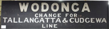 Wodonga & District Historical Society Inc
Sign - Wodonga Railway Station Sign
The Wodonga train line opened in November 1873 when the section of the train line from Wangaratta to Wodonga was completed. A goods shed was built at this time in 1873 and a permanent train station was completed in 1874. The expansion of the railways to the northeast of Victoria occurred after the Victorian Government took over the railways in 1867 and the trains serviced large towns such as Seymour, Wangaratta and Wodonga, as well as smaller towns along the way. The Tallangatta and Cudgewa train lines from Wodonga were built in stages from the 1880s to the 1920s in what is considered to be some of the most challenging landscape for railways. The Cudgewa line was opened in 1921, so the Wodonga train station sign dates from this period.The Wodonga train station sign has local and state significance due to its use in Wodonga in the late 19th and early 20th centuries, as part of the expansion of the Victorian Railways in the northeast of the state.Old painted wooden sign from the Wodonga train station with the directions for changing to the Tallangatta and Cudgewa train line in light coloured paint on a black painted background."WODONGA / CHANGE FOR / TALLANGATTA & CUDGEWA / LINE" wodonga railway station, wodonga train station, tallangatta train line, cudgewa train line, railway signs, victorian railways signs -
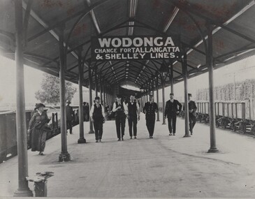 Wodonga & District Historical Society Inc
Photograph - Fred Rochow Railways Collection - Wodonga Railway Station, C. 1916 - 1930
... AND SHELLEY LINES" Railway men walking along the Wodonga Railway ...The Fred Rochow Railways Collection incorporates photos related to the operation of the Wodonga Railway Station including different types of trains and railways staff C. 1930 – 1990. It was donated to the Wodonga Historical Society by Fred Rochow, a railwayman who spent many years based in Wodonga. He joined the Victorian Railways on 17th June l947 and retired in 1988. For some time, he was a member of the Australian Federated Union of Locomotive Enginemen and served a term as a member of the Trades Hall Council. He had an extensive knowledge of the struggles that took place to achieve better conditions for railway workers. Fred worked for many years as a fireman and then worked his way up the ranks to driver, experiencing many changes from the days of steam locomotives through to diesel trains, locomotives and even the modern XPT train. He worked throughout Victoria at different stages of his career, with his final working years focused on the northeast of Victoria and the Albury to Melbourne line. After his retirement, Fred continued to share his love of steam miniature trains with the community.This collection has local and statewide significance as it captures images of trains, locomotives and personnel who operated the railway services in Wodonga and throughout Northeast Victoria. The railways played a critical role in opening up Victoria and connecting Australia for trade, business, social communication and transport.Railway men walking along the Wodonga Railway Platform. The sign overhead advises of changes to the Tallangatta and Shelley lines. Cudgewa Line -The Cudgewa railway line opened in stages between 1889 and 1921. The first section from Wodonga to Huon opened on 10 September 1889. It was extended to Bolga on 18 July 1890, Tallangatta on 24 July 1891 and then to Shelley on 13 June 1916. Shelley was the highest station in Victoria. It extended further on to Beetomba on 10 April 1919 and finally reached Cudgewa on 5 May 1921. The line had 1 in 30 grades and trestle bridges that have been heritage listed. In 1919, the line was used to carry materials for the construction of Hume Weir, and three years later a spur line connecting Ebden to the weir was opened. In the 1960s, Cudgewa became the railhead of materials for the Snowy Mountains Scheme. The last passenger service from Wodonga to Tallangatta ran on 30 September 1961. The turntable and passenger platform at Cudgewa were abolished in 1976. On sign hanging overhead "WODONGA/ CHANGE FOR TALLANGATTA AND SHELLEY LINES"railways wodonga, fred rochow, wodonga railwaymen, cudgewa rail line, wodonga railway station -
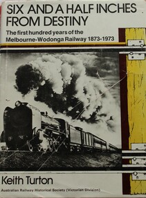 Wodonga & District Historical Society Inc
Book - Six and a Half Inches from Destiny: First 100 Years of Melbourne to Wodonga Railway, 1873 - 1973, Keith W. Turton
Inter-colonial railway communication was established in 1883 when the Melbourne - Wodonga railway was extended over the River Murray to meet the New South Wales railhead at Albury. When the two lines finally met a significant fact became apparent - the track gauges of the two systems differed by six and a half inches. For 80 years this difference created havoc until a new railway of uniform gauge was built parallel to the Victorian gauge line from Melbourne to Wodonga. This book deals with the planning, construction and the first 100 years of operation or the railway to Wodonga, together with its locomotives, stations and trains which travelled its tracks.non-fictionInter-colonial railway communication was established in 1883 when the Melbourne - Wodonga railway was extended over the River Murray to meet the New South Wales railhead at Albury. When the two lines finally met a significant fact became apparent - the track gauges of the two systems differed by six and a half inches. For 80 years this difference created havoc until a new railway of uniform gauge was built parallel to the Victorian gauge line from Melbourne to Wodonga. This book deals with the planning, construction and the first 100 years of operation or the railway to Wodonga, together with its locomotives, stations and trains which travelled its tracks.railways victoria, railway melbourne to wodonga