Showing 6754 items matching " rivers"
-
 Orbost & District Historical Society
book, Snowy River Story, April 2005
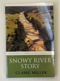
This book recounts the story of the campaign by Dalgety and Orbost to restore water to the Snowy River. Claire Miller is a senior journalist for The Age newspaper with a special interest in the environment. She has covered this campaign since 1999.This book recounts the story of the campaign by Dalgety and Orbost to restore water to the Snowy River. It is significant to this collection as many of the current residents of Orbost were involved in the campaign.A 270pp paperback book titled Snowy River Story written by Claire Miller. On the front cover is a coloured photograph of the Snowy River at Bete Bolong. It documents the story of the campaign to save the Snowy River.snowy-river snowy-mountains-hydro-electric-scheme environmental -
 Glenelg Shire Council Cultural Collection
Photograph - Photograph - Casterton, Victoria, c. 1963
SOURCED FROM CASTERTON TOWN HALL (FORMER SHIRE OF GLENELG)Black and white photo of Glenelg River Bridge at CastertonBack: 'Glenelg River Bridg at Casterton' handwritten, blue biro. Blue line, arrowed each end, drawn across photo, 3" written above line. Black number stamp.glenelg river, casterton, tourism -
 Wodonga & District Historical Society Inc
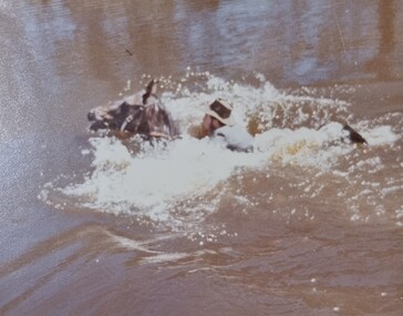
Album - Ringer's River by Des Martin - Plate 21 - Swimming cattle across to Victoria
But O'Day, the general, has chosen this particular time to ride up river and meet a mob of cattle that Charlie Clowes is bringing down for him from Camoola. In the first of many such successful operations the cattle are swum across to Victoria at the point where O'Day's run, Brightons, comes down to the river.The album and images are significant because they document literature written by a prominent member of the Wodonga community. The presentation of this precis was supported by several significant district families and individuals.Ringer's River Album Coloured photo Plate 21des martin, many a mile, ringer's river, northeast victoria stories -
 Orbost & District Historical Society
photograph, late 19th - early 20th century
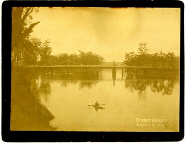
Frank Richardson 1877-1950 was a sawmiller at Tabbara and helped build and run paddle steamer "Curlip"as engineer.This item is an early pictorial record of the old Snowy River bridge at Orbost.A large b/w photograph of the Snowy River bridge at Orbost. In the foreground there is a man in a small canoe with paddles. The photograph is pasted onto a black buff card. 2606.2 is a copy of the original used for display.On front : "Eastwood Bros, Bairnsdale, Orbost Bridge over Snowy River".photograph-snowy-river-bridge eastwood-bros -
 Greensborough Historical Society
Photograph, Plenty River Greensborough, 1910c
It shows the Plenty river in Greensborough in flood and the bluestone bridge at the bottom of the Main Street hill.The bluestone bridge was built in the mid 1860's and was demolished 1970's.A black and white photograph of a bridge over a river in flood.Nilgreensborough, plenty river, floods, bridges, bluestone -
 Wodonga & District Historical Society Inc
Album - Ringer's River by Des Martin - Plate 29 - Keiran drowns
A flash flood caused by the cloudburst upstream catches them all in the river and Keiran is drowned.The album and images are significant because they document literature written by a prominent member of the Wodonga community. The presentation of this precis was supported by several significant district families and individuals.Ringer's River Album Coloured photo Plate 29des martin, many a mile, ringer's river, northeast victoria stories -
 Port Fairy Historical Society Museum and Archives
Photograph
The Dredge 'Pioneer' brought in to clear sand drift from the Moyne river caused by the South West passage sweeping throughBlack and white photograph of a dredge in Moyne riversea, river, moyne river, south west passage, pioneer, deredge, ship -
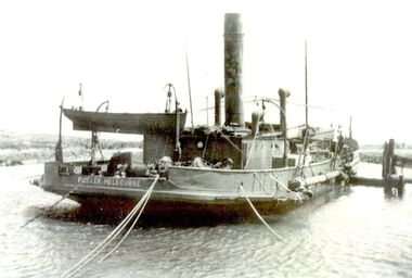
 Port of Echuca
Photograph - Black & white photograph of boats tied up at Morgan Wharf, Boats tied up at Morgan Wharf, 19/09/1984
Shows the extent of the River trade in the Murray Darling River basin in the early 20th Century.Helps show the extent of river trade in the Riverland area of South Australia in the early 20th Century.Copy of an original photograph of a wharf scene with moored river boats. possibly of Morgan c. 1900.Written on back in pencil."boats tied up at Morgan-?"murray river, paddle steamers, river boats, morgan. south australia., riverland -
 Peterborough History Group
Photograph - Photographs of The Bridge over The Curdies River
Historic views of the old wooden bridge, since replaced, and also showing the configuration of the river at that time.River and bridge integral part of Peterborough life. Digital image of two black and white photographs of the Bridge over the Curdies River, both taken from the East side showing different water levels in the rivercurdies river, curdies river bridge peterborough, peterborough victoria, great ocean road, curdies river estuary -
 Marysville & District Historical Society
Photograph (item) - Black and white photograph, Unknown
A digital copy of an early black and white photograph of the Taggerty River.A digital copy of an early black and white photograph of the Taggerty River.taggerty river, photograph -
 Marysville & District Historical Society
Photograph (item) - Black and white photograph, Unknown
A digital copy of an early black and white photograph of the Taggerty River.A digital copy of an early black and white photograph of the Taggerty River.taggerty river, photograph -
 Marysville & District Historical Society
Photograph (Item) - Black and white photograph, Unknown
A copy of a black and white photograph of the bridge over the Steavenson River.A copy of a black and white photograph of the bridge over the Steavenson River. The Steavenson River is named after the Victorian Assistant Commissioner of Roads and Bridges, John Steavenson who arrived in Victoria in the early 1860s.marysville, victoria, steavenson river, photograph, john steavenson -
 Marysville & District Historical Society
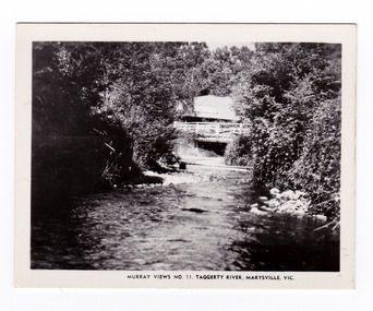
Photograph (item) - Black and white photograph, Murray Views, Murray Views No. 11. Taggerty River, Marysville, Vic, Post 1929
An early black and white photograph of the Steavenson River in Marysville, Victoria.An early black and white photograph of the Steavenson River in Marysville, Victoria. The Steavenson Falls is named after the Victorian Assistant Commissioner of Roads and Bridges, John Steavenson who arrived here in the early 1860s. This photograph was published by Murray Views in Gympie, Queensland, as a souvenir of Marysville.marysville, victoria, photograph, murray views, souvenir, steavenson river, john steavenson -
 Marysville & District Historical Society
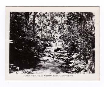
Photograph (item) - Black and white photograph, Murray Views, Murray Views No. 45. Taggerty River, Marysville, Vic, Post 1929
An early black and white photograph of the Taggerty River in Marysville, Victoria. An early black and white photograph of the Taggerty River in Marysville, Victoria. This photograph was produced by Murray Views in Gympie, Queensland as a souvenir of Marysville.taggerty river, marysville, victoria, murray views, photograph, souvenir -
 Marysville & District Historical Society
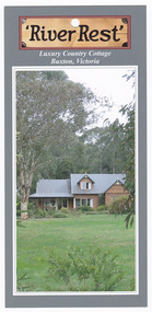
Flyer (item) - Accommodation flyer, 'River Rest', Unknown
An information flyer regarding accommodation at River Rest cottage in Buxton.An information flyer regarding accommodation at River Rest cottage in Buxton.buxton, victoria, australia, river rest country cottage, accommodation, flyer -
 National Vietnam Veterans Museum (NVVM)
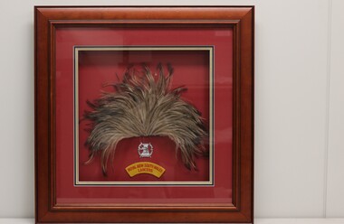
Memorabilia - Framed hat plume
Part of the estate collection of Vietnam veteran Sgt T J Nicholson, Service no: 4410261, who served in 1st Armoured Regiment, Vietnam 1969-70.Wooden shadow box frame with a maroon matt background containing an emu hat plume, a Hunter River Lancers silver plastic corps badge and yellow wool felt shoulder patch of Royal New South Wales Lancers.Hunter River Lancers Royal New South Wales/ Lancershunter river lancers, royal new south wales lancers, nicholson, trevor nicholson, 1st armoured, 441026, lancers, plume -
 Bendigo Historical Society Inc.
Book - River Control in New Zealand and Victoria, 1941
... Rivers ...This book was commissioned by the State Rivers and Water Supply Commission on the recommendation of Frank E. Old, Minister of Water Supply to meet the need for a comprehensive and progressive policy of river improvement. This book was presented to Milton King, the father of the donor Neville King.Khaki coloured hard cover book. 131 pp. Black and white illustrations and diagrams. Author H.G.Strom, BCE, AMIE. Australia. Neville King CollectionM R King 29/08/41 written in pencil inside the front cover.water supply, rivers, h g strom -
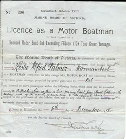 Warrnambool and District Historical Society Inc.
Document, Licence Motor boatman, 1918
This is a licence issued to Leslie Palmer in 1918. It gives him authority to operate a motor boat across the banks of the Hopkins River near the mouth and to carry passengers. As there is a bridge at the mouth of the river it is assumed that this motor boat was used to go across the river from a private house, making it more convenient than going by road to cross the bridge. It was, and still is, a common practice to use boats to cross the river from private homes built along the banks of the Hopkins River.This is a significant item as it is an original certificate and is interesting because the licence was a restricted one, for use only in crossing the Hopkins River. This is a paper licence issued by the Marine Board of Victoria in 1918. The certificate has printed material and entries written in black ink. It has the seal of the Marine Board and the signature of the SecretaryWritten material: ‘Leslie Alfred Palmer of Warrnambool, oil, on the Hopkins River within a line bearing east from Point Ritchie on the western side of the mouth of such river to the opposite shore, 6th December 1918’ motor boat licence 1918, warrnambool, leslie palmer, hopkins river -
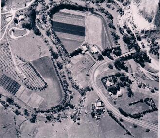 Hume City Civic Collection
Photograph
The aerial photograph shows the market garden situated on the river bend and flat of the Deep Creek at Bulla. In the 19th Century a hotel occupied the site. After World War II the property was owned by the Hughes family, who grew flowers. In 1971 Andrew Vlass purchased the property and it became a market garden until the Vlass family sold it in 1990.A black and white aerial photograph of the river bend and river flat of the Deep Creek at Bulla.scale - 170 feet = 1 inchdeep creek, market gardens, sunbury road, bulla, horticulture, hughes family, vlass, andrew, hotels, george evans collection -
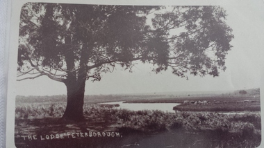 Peterborough History Group
Postcard - The Lodge Postcard
Historic picture of the Curdies River, with reference to the farm known as The Lodge. the Lodge is also the name given to the good fishing spot on the banks of the Curdies which is accessed by a track through farmland.Historic and social significancePostcards depicting the Curdies River at The Lodge.Hand written letter on the back "To Cora, from Auntie May"james irivine, the lodge farm, curdies river - view, curdies river peterborough, curdies river, vintage postcards -
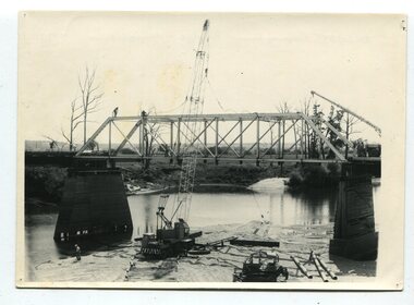 Orbost & District Historical Society
black and white photographs, 1977
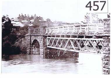
This is a series of photographs of the demolition of the 1922 bridge across the Snowy River at Orbost. This bridge over the Snowy River was opened on July 4 1922. It was constructed in 1922 alongside the previous suspension bridge. Its building was a combined effort of the Victorian Railways and the Country Roads Board at a cost of 35,000 pounds. It was replaced in 1976 by the present bridge after several major floods.This bridge was replaced in 1976 after several major floods. These photographs record the demolition of that bridge.Ten black / white photographs of a road bridge demolition. In the photographs are cranes, one on a barge, and workmenon back - Orbost Snowy River Bridge demolition 1977 -
 Wodonga & District Historical Society Inc
Photograph - The River Port of Red Bank
THE RIVER PORT OF REDBANK During the 1870s, Red Bank would have been one of the busiest ports on the Murray River. When the railway line was being built from Melbourne to Wodonga all the railway material was brought up river from Echuca by paddle steamer and barge and unloaded at Red Bank. The material was loaded onto horse teams or bullock wagons and taken along the route of the spur line. During the 187 MacCulloch & Co. handled 3000 tons of railway material here' The port was operational from approximately 1870 until 1874. THE FIG TREES The fig trees and a small bank of gravel are the only visible reminders of where the spur line from the wharf at Red Bank met the main line. It was at this point that all the material for the mainline was transferred from the small locomotives and wagons from Red Bank. It would have been carried by bullock wagons and horse teams and unloaded at different places as the line progressed. After the line was completed in 1873 the fettlers from Wodonga would patrol this length of the line.These images are significant because they document an important stage in the development of transportation in North East Victoria.Images of the River Port of Red bank near Wodonga on the Murray River. 1. The wharf 2. All that remainsred bank port, historic wharf wodonga, river transport -
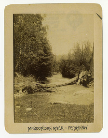 Marysville & District Historical Society
Photograph (Item) - Black and white photograph, Maroondah River - Fernshaw, c1900
An early black and white photograph of the Watts River at Fernshaw. The photograph has been incorrectly labeled as the Maroondah River - Fernshaw.An early black and white photograph of the Watts River at Fernshaw. The photograph has been incorrectly labeled as the Maroondah River - Fernshaw.ARMSTRONG COLLECTION 42 STATION STREET/ SANDRINGHAM 3191/ TEL. (03) 9521 5442/ IAN M.L. ARMSTRONG OAMwatts river, fernshaw, maroondah river, victoria -
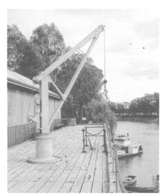
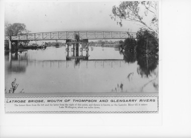 Lakes Entrance Historical Society
Photograph, Caire, Nicholas John, Swing Bridge Sale Victoria, 1905c
turning on a central axis to allow the passage of river vessels. Image shows machinery for operation and the bridge closed to river traffic. Latrobe Wharf on the left bank is seen through bridge. Sale VictoriaBlack and white photograph of the Latrobe Bridge. This was a swing bridge over the Latrobe Riverbridges, waterways, civil engineering, jetties -
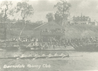 Lakes Entrance Historical Society
Photograph - Rowing Club at Bairnsdale Victoria, 1902
... Rivers ...Black and white photograph showing rowing skull with eight crew on Mitchell River large crowd of onlookers on bank during official opening of Rowing Club at Bairnsdale Victoria. Also a small black and white postcard showing same eventBiarnsdale Rowing Clubsports, events, rivers -
![Waterfall Scene Near the Buchan River / [by] Nicholas Caire, circa 1876](/media/collectors/550653872162f11fb04854aa/items/57825da5d0cdd1176ce3ed3d/item-media/57825e03d0cdd1176ce418cf/item-fit-380x285.jpg) Kew Historical Society Inc
Kew Historical Society IncPhotograph, Anglo-Australasian Photographic Company, Waterfall Scene Near the Buchan River, c. 1876
Nicholas Caire was born on Guernsey in the Channel Islands in 1837. He arrived in Adelaide with his parents in about 1860. In 1867, following photographic journeys in Gippsland, he opened a studio in Adelaide. From 1870 to 1876 he lived and worked in Talbot in Central Victoria. In 1876 he purchased T. F. Chuck's studios in the Royal Arcade Melbourne. In 1885, following the introduction of dry plate photography, he began a series of landscape series, which were commercially successful. As a photographer, he travelled extensively through Victoria, photographing places few of his contemporaries had previously seen. He died in 1918. Reference: Jack Cato, 'Caire, Nicholas John (1837–1918)', Australian Dictionary of Biography.An original, rare photograph from the series 'Views of Victoria: General Series' by the photographer, Nicholas Caire (1837-1918). The series of 60 photographs that comprise the series was issued c. 1876 and reinforced a neo-Romantic view of the Australian landscape to which a growing nationalist movement would respond. Nicholas Caire was active as a photographer in Australia from 1858 until his death in 1918. His vision of the Australian bush and pioneer life had a counterpart in the works of Henry Lawson and other nationalist poets, authors and painters.‘Waterfall scene near the Buchan River’ : Views of Victoria (General Series), No.39 : Albumen silver photograph | Photo on card with Title and Description on reverse | Mounted 24 x 30 cm; Photo 12 x 17 cm.On Reverse: ‘The Buchan River is a tributary of the great Snowy River, which extends itself from Port Ricardo, on the Gipps Land coast, to considerably beyond Mt. Kosciusko, in New South Wales. It is comparatively but a stream, but, like most of the smaller rivers in Victoria, it contains some beautiful scenery, peculiar to itself. Our present illustration is characteristic of its scenery, and is taken from a creek close to the River.’nicholas caire (1837-1918), buchan river, landscape photography - victoria -
 Kew Historical Society Inc
Photograph, Standard Newspapers, Charles Grimes Re-enactment, Yarra River, 1978
The party of the British surveyor Charles Grimes were the first Europeans to view the River Yarra, as it was later to be named. Members of the party reached the area now known as Studley Park in 1803. This local re-enactment commemorated 175 years since that event. Charles Grimes Re-Enactment, Yarra River, Kew, 1978. The photograph is of a student of Trinity Grammar School and the Mayor of Kew, Cr. Whiting. Inscription on reverse: "KH-161. Society's contribution to the 1978 Festival of Kew. Re-enactment of first white man's journey and discovery of the Yarra River and the area now know (sic) as Kew. 1978. This was in the year 1903 when Grimes and party came upon the Yarra to seek a possible site for a new convict settlement. Cr. Whiting, Mayor of Kew, receiving the report from Grimes, 'Andrew Allen'. Cr. Hutchinson in top hat 'town cryer'. Bush band in backround." Ripped stamp on reverse: "Standard N[ewspapers]."charles grimes re-enactment, trinity grammar school, cr whiting -- mayors -- kew (vic.), yarra river, andrew allen, kew historical society -
 Port Fairy Historical Society Museum and Archives
Photograph
Moyne River FootbridgeColoured photograph of the Moyne river taken from the West side of the footbridge looking to the wharfmoyne river, foot bridge, jetties, wharf, boats -
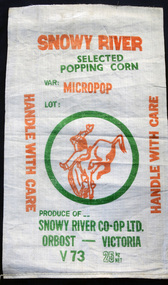 Orbost & District Historical Society
seed bag, mid 20th century
The bag is unused. These bags would have been used by the Snowy River Co-Op in Orbost in the late 1960's-1980's. It would have been used for packing popping corn for sale. Snowy River Seeds started life as a farmers' co-operative (Snowy River Co-op) in 1967.This item is significant because it was specially made for the seed bean industry which has been a major industry in the Orbost district for over a century.A white woven synthetic fibre bag used to store popping corn prior to selling.On front of bag - Inside green circle is "Man From Snowy River" in orange and green writing. 25kg net Variety is Micropop Produce of..... Snowy River Co-Op Ltd Orbost - Victoriacorn seed-bag snowy-river-co-op