Showing 1625 items
matching yarra river
-
 Port Melbourne Historical & Preservation Society
Photograph - Aerial view of River Yarra and Victoria Dock, 1920s
... Aerial view of River Yarra and Victoria Dock...Copy of aerial photo of River Yarra and Victoria Dock... transport - shipping Copy of aerial photo of River Yarra ...Copy of aerial photo of River Yarra and Victoria Dock, 1920s; pasted onto A4 sheet with computer graphics bordertransport - shipping -
 University of Melbourne, Burnley Campus Archives
Photograph - Black and white print, Aerial View of Burnley Campus c.1965, c. 1965
... yarra river... view of Burnley College encompassed by the Yarra River... Boulevard Richmond melbourne aerial view burnley college yarra river ...Black and white photograph. Enlarged photograph of aerial view of Burnley College encompassed by the Yarra River and showing the surrounding suburban areas. Mounted on cardboard.aerial view, burnley college, yarra river -
University of Melbourne, Burnley Campus Archives
Newspaper - Newspaper Cutting, Progress Leader, Standing on Sacred Ground, 2001
... yarra river.... Article describing early history of the lower Yarra River...progress leader mathew dunckley yarra river richmond park ...Article in "Progress Leader" 13.08.2001 by Mathew Dunckley. Article describing early history of the lower Yarra River, Richmond Park and Burnley Horticultural College.progress leader, mathew dunckley, yarra river, richmond park, burnley horticultural college, history, the yarra trail guide, corroboree tree -
 Kew Historical Society Inc
Map, MMBW, River Yarra Beautification Schemes, c.1913
... River Yarra Beautification Schemes...Map of the City of Kew showing part of the River Yarra...MELBOURNE AND METROPOLITAN BOARD OF WORKS / RIVER YARRA... MELBOURNE AND METROPOLITAN BOARD OF WORKS / RIVER YARRA ...The Melbourne and Metropolitan Board of Works (MMBW) was established by an act of the Victorian Parliament in 1890 to prepare for and to implement a sewerage and water reticulation system across what was then inner Melbourne, its surrounding and middle distance suburbs, including Kew. The MMBW was disbanded in 1991.The map collection of the Kew Historical Society has at its core the historic maps assembled and originally stored in the City Engineer's Department of the City of Kew. These include maps in a number of scales. The vast majority of maps were produced by the MMBW in the first two decades of the twentieth century, and are solid working maps, backed by linen for durability. These maps are historically significant to Kew, the City of Boroondara and to the history of the development of state utilities in Victoria. A number of the Kew maps have additional details added by former municipal officers, including the levels reached by various floods. As these were working documents, information was added to them long after the period of their initial production and distribution.Map of the City of Kew showing part of the River Yarra Beautification Schemes. The map shows development to date and the flood levels reached in 1923 and 1924. This map may have been adapted from an earlier map, as most development in central Kew and Studley Park had occurred by this date yet numerous streets are not represented. Public buildings and institutions are clearly represented and named on the map as are significant public transport infrastructure (eg the Outer Circle railway).MELBOURNE AND METROPOLITAN BOARD OF WORKS / RIVER YARRA BEAUTIFICATION SCHEMES / SCHEME / SCALE 10 CHAINS TO AN INCHmelbourne & metropolitan board of works, mmbw maps, mmbw plans, city of kew, flood levels -- kew (vic.), cartography -
 Kew Historical Society Inc
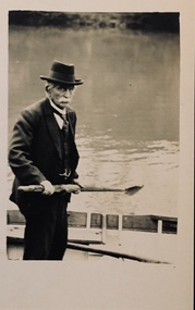
Photograph - Orlando Henry Beater Christian, 1920s
... row boats -- yarra river -- kew (vic.)..., presumably on the Yarra River. He is wearing a suit and has a hat on.... boats -- yarra river -- kew (vic.) Small black and white ...An item from an outstanding and diverse photographic collection, assembled by members of the Christian and Washfold families of Kew.Small black and white photograph of the elderly Orlando Henry Beater Christian holding an oar while standing in a canoe, presumably on the Yarra River. He is wearing a suit and has a hat on.orlando henry beater christian, christian-washfold collection, row boats -- yarra river -- kew (vic.) -
University of Melbourne, Burnley Campus Archives
Plan - Photocopy, Contour Map 1891, 1891
... yarra river...Photocopy of plan showing contour lines from Yarra River...yarra river pavilion Burnley Horticultural College Burnley ...Photocopy of plan showing contour lines from Yarra River. Shows Pavilion and Principal's Residence but not much of the garden design. From Central Plan Office Dept. of Natural Resources."Contour map 1891" written in biroyarra river, pavilion, burnley horticultural college, burnley gardens -
Port Melbourne Historical & Preservation Society
Map - Navigation Charts, Port Melbourne, Williamstown and River Yarra, 1994
... Navigation Charts, Port Melbourne, Williamstown and River... and River Yarra channels 1994. Chart No Aust 154 .02 - Navigation..., Williamstown and River Yarra channels 1994. Chart No Aust 154 .02 ....01 - Navigation chart of Port Melbourne, Williamstown and River Yarra channels 1994. Chart No Aust 154 .02 - Navigation Chart of approaches to Melbourne. Chart No Aust 155 c1986sport - yachting, maritime, beacons -
Port Melbourne Historical & Preservation Society
Photograph - Aerial view of Port Melbourne, overlaid, Charter Keck, Cramer, Nov 2006
... yarra river... . Shows Yarra River, Coode Canal and Hobson's Bay.... island yarra river melbourne harbor trust - port of melbourne ...Black and White aerial photo with red map overlay, labelled "Port Melbourne 1946 overlaid" in gold/brown metal frame . Shows Yarra River, Coode Canal and Hobson's Bay.built environment - industrial, engineering - canals and drainage, coode island, yarra river, melbourne harbor trust - port of melbourne authority -
 Kew Historical Society Inc
Photograph, Marnie McLeod, Flood, River Yarra, Kew, 1916
... Flood, River Yarra, Kew...river yarra... in the collection. Together with our original MMBW River Yarra map showing ...The donation was accompanied by the following letter from the donor: "Hi. I found these in with family photos. Taken by family as Mamie McLeod was living in Fellows Street, Kew, so would be near there. Retain (or discard) as you see fit." [Donor's name and address withheld from public view]. To gain an insight into the flood levels at Kew, it is worth reading newspaper accounts of the event. The Age published an article - Valuable Gardens Destroyed at Kew - on 25 September 1916: "VALUABLE GARDENS DESTROYED AT KEW. From the heights of Studley Park, Kew, a splendid view of the flood waters can be obtained, and yesterday afternoon, despite continuous rain, crowds of citizens assembled there to witness the spectacle. There is a vast stretch of water some 300 or 400 yards broad, above the foot bridge connecting Gipps-street, Collingwood, and Studley Park. The river is only about 3 feet from the top of the embankment connecting with the ramp of the bridge on the Studiey Park side. When the upper llood waters come down it is almost a certainty that tne embankment will be submerged and the bridge rendered impassible. Below the bridge the waters again stretch out, and have submerged all the low-lying land on the Collingwood side and invaded the back premises ot the Kodak Co., Phoenix Biscuit Factory, a tannery adjoining thereto, the Shamrock Brewery, and Chinese gardens in the vicinity. At Walmer-street-bridge, at the end of Studley Park, the low-lying land on the Kew side is covered with water to the depth of many feet. Tlie land in question is owned in a great part by Mr Frank Lavers who haa gone in for intense culture on a pretty liberal scale on both the slopes of the hill and on the river flat. On the latter he is cultivating many acres of asparagus, and has at a considerable cost spent three years in preparing the ground and installing an irrigation system, reticulated from the Yan Yean water supply. This year the asparagus was put down, and the plants were in a promising condition. Tlie flood waters are now flowing fast over the land. The crop is ruined, and three years' work and expenditure destroyed. Mr. Laver's private residence fortunately is high above flood level, but two houses he owns off Young-street have been flooded out. Having been warned in time, the tenants removed their furniture hefore the water came down to Mr. Laver's residence, where they themselves have been given accommodation in the meantime. All the river flats in East Kew are under water. One or two low-lying houses have been flooded. Chipperfield's boat shed at Willsmere is nearly covered, and some Chinese gardens in the vicinity are several feet under water."This, and the other three photographs donated of floods in Kew are believed to be the earliest in the collection. Together with our original MMBW River Yarra map showing flood levels, these items, when compared allow researchers to gain a visual perspective of the extent of the flood in 1916. Small black and white photograph of flooded trees in Kew.Inscription on reverse in ink "Flood R. Yarra Kew Vicriver yarra, kew, floods 1916 -
 Kew Historical Society Inc
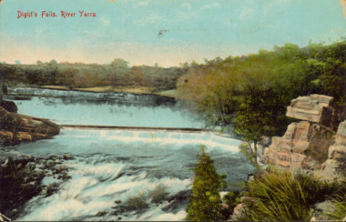
Postcard - Dight's Falls, River Yarra, c.1911
... Dight's Falls, River Yarra...Colour postcard, of Dight's Falls on the River Yarra... right Colour postcard, of Dight's Falls on the River Yarra ...Dight’s Falls in Studley Park is an artificial weir built on a natural rock bar across the Yarra. The weir was built in the 1840s to provide water to the ‘Ceres’ flour-mill, one of the first in Victoria. The falls were later to become known as Dight’s Falls after the owners of the mill. Later, a pumping station was built on the Kew side of the river, which pumped water uphill to a reservoir in Walmer Street that provided water to the Melbourne Botanical Gardens and to Albert Park Lake. The area around Dight’s Falls was and is frequently used for recreational activities.Dated postcard allowing one to analyse the form of the Falls in 1911Colour postcard, of Dight's Falls on the River Yarra between Kew and Fairfield. The photograph is taken looking upstream towards the Falls from the Kew side, from the embankment in the vicinity of the Pumping Station. Obverse: "Dight's falls, Kew" Reverse: "Printed in Great Britain Writing in ink on Reverse: "31/3/1911 / To dear Nell with best wishes for a happy birthday from your old friend Eve / [Addressed to] "Mrs N Dunn, Prahran" Franked Victorian 1d stamp on Reverse top rightdight's falls, dight's falls - kew (vic) - fairfield (vic) -
 Mission to Seafarers Victoria
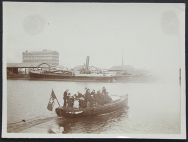
Photograph - Photograph, Sepia, circa 1910
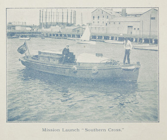
... yarra river... the Yarra River. In the background we can see the "Robur Tea House... launch southern cross yarra river australian wharf south wharf ...The motorboat Southern Cross was used for ship visits and also to Bring sailors back to the Mission or picnics.A group of ladies and seamen sitting on the "Southern Cross", the Mission's motor launch, leaving the Australian Wharf and crossing the Yarra River. In the background we can see the "Robur Tea House" warehouse and the south wharf.motor launch, southern cross, yarra river, australian wharf, south wharf, flag, lhlg, robur tea house, missions to seamen, goldsmith album, motorboat, charles blunt, blunt boatbuilders, geelong -
 Ringwood and District Historical Society
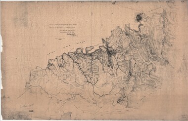
Map, Survey of Dividing Range between Yarra Yarra and Western Port - William Wedge Darke, 1843
... survey of the Dividing Range and the country between the Yarra... including Yarra Yarra River, Mullum Mullum Creek, Anderson's Creek... area of Yarra River - "impassable, appears to have been... the Yarra River and Western Port, completed in May 1843, and during ...Extract - Ringwood, Place of Many Eagles - Hugh Anderson (1974): William Wedge Darke, from Hereford, England, was a nephew of John Helder Wedge of the Port Phillip Association, who was also a surveyor. William's most important work was probably his survey of the Dividing Range and the country between the Yarra River and Western Port, completed in May 1843, and during which he made a traverse between the Mullum and Dandenong creeks along the higher ground that he labelled the "best line of road from Melbourne". This road was for many years the major route to Gippsland and to the higher country about Alexandra and Mansfield, sometimes known as White Horse Road, and now Maroondah Highway.Surveyor's relief map of features to the east of Melbourne including Yarra Yarra River, Mullum Mullum Creek, Anderson's Creek, Dandenong Creek.Transmitted to the Surveyor General with my letter of 10th May 1843 (signed) Wm Wedge Drake, Assistant Surveyor. Scale: two inches to a mile. Descriptive remarks include upstream area of Yarra River - "impassable, appears to have been formerly a lake", and to the south - "barren and scrubby swamps of the Western Port Country". Marked tracks include "best line of road from Melbourne", "track to Dandenong", "Road to Port Albert may probably be found on this range", "Best line to Upper Yarra". Several huts also marked. -
 Kew Historical Society Inc
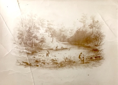
Print, View on the Yarra Near Dights Falls, Nineteenth Century
... yarra river... of the River Yarra fro both recreation and industry.... and boys on the banks of the River Yarra. The activities... The original book plate reflects the colonial use of the River Yarra ...The original book plate reflects the colonial use of the River Yarra fro both recreation and industry.View on the Yarra Near Dights Falls. Reproduction of a book plate from an original wood engravingg, showing men and boys on the banks of the River Yarra. The activities represented include logging and fishing. Annotation on reverse: [Original] "Caption: View on the Yarra Near Dights Falls."yarra river, dights falls -
 Mission to Seafarers Victoria
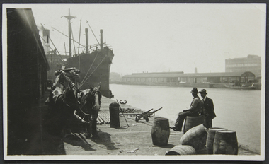
Photograph - Photograph, Black and white, Reverend John Reginald Weller, On the Australian Wharf, c. 1925
... yarra-river... siting on a barrel. Across the Yarra river: docks... melbourne australian-wharf yarra-river robur tea house weller album ...Black and white photograph with a thin white border depicting the Australian wharf: two horses, steam ship, two men one siting on a barrel. Across the Yarra river: docks and in the background, the Robur Tea House.Stamps: In purple ink: Herschell's Print, Pathe Agents / in blue ink: "384" Handwritten in black ink and in pencil: "6" australian-wharf, yarra-river, robur tea house, weller album -
 Bendigo Historical Society Inc.
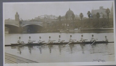
Photograph - PHOTOGRAPH OF ROWING TEAM, 1920
... Yarra River... on the Yarra River Melbourne showing city buildings in the background... ORGANIZATION Club/society rowing team Rowing Team Yarra River ...Black and white photograph of an 8 man rowing team on the Yarra River Melbourne showing city buildings in the background, mounted on grey card within a thin black wooden frame, markings read 'Burlington Melb'Burlington Melborganization, club/society, rowing team, rowing team, yarra river, burlington -
Nillumbik Shire Council
Mixed Media (installation): John R. NEESON (b.1956 AUS), John R Neeson, Riverbend Project, 2015
... ekphrasis 2016, neeson, easel, oil painting, yarra river...Wooden easel holding an oil on board painting of the Yarra..., neeson, easel, oil painting, yarra river, digital photograph ...John R Neeson was a Laughing Waters Artist in Residence in 2015. During his residency Neeson made site specific trompe-l’oeil paintings and time based videos that referenced the changes of light upon the Knox architecture and the environment of Laughing Waters.Wooden easel holding an oil on board painting of the Yarra River and surrounding landscape at Laughing Waters (detailed view). Behind the painting and easel is a digital photograph of the painting and easel in situ in the landscape. The photograph is printed on aluminium. No inscriptions and markingsekphrasis 2016, neeson, easel, oil painting, yarra river, digital photograph, landscape, in situ, site specific, riverbend -
University of Melbourne, Burnley Campus Archives
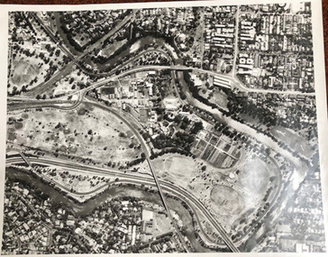
Photograph - Black and white print, Aerial View of Burnley Campus, 1977
... yarra river... in the bend of the Yarra River, Glenferrie Road to the East Swan...University of Melbourne, Burnley Campus Archives 500 Yarra ...Framed enlargements. (A) Burnley College and surrounding suburbs showing the nearly constructed Freeway, the College in the bend of the Yarra River, Glenferrie Road to the East Swan Street to the North. (B) Enlargement of (A) showing detail of Burnley College.burnley college, suburbs, freeway, yarra river, glenferrie road, east swan street, aerial view -
 Mission to Seafarers Victoria
Photograph, Mission Launch Southern Cross, c. 1910
... yarra river... on the Yarra River near the Docklands Gasworks.... launch southern cross yarra river gasworks docklands flinders ...The motor boat built by Charles Blunt was donated in 1906, and was useful for ships' visit.Printed photograph published in the Annual Report for 1910 on page 35, depicting Reverend Alfred Gurney Goldsmith on board the mission's motor boat with another man. The image was taken on the Yarra River near the Docklands Gasworks.alfred gurney goldsmtih, motor boat, motor launch, southern cross, yarra river, gasworks, docklands, flinders street, charles blunt, blunt boatbuilders, geelong -
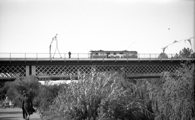 Melbourne Tram Museum
Negative, Wal Jack, c1941
... Yarra River... bridge over the Yarra River. Photo not dated, in the Wal Jack... Trams tramways Swan St Wallen Road Bridges W2 class Yarra River ...Black and white negative, by Wal Jack, of W2 392 (from information in the Wal Jack Album) crossing the Swan St or Wallen St bridge over the Yarra River. Photo not dated, in the Wal Jack album.trams, tramways, swan st, wallen road, bridges, w2 class, yarra river, tram 392 -
 University of Melbourne, Burnley Campus Archives
Album - Black and white and colour prints, Brian Ward, Freeway Construction, 1963-1972
... river yarra... photographs of views of the Yarra River near Burnley Gardens. (3...freeway burnley gardens yarra river yarra boulevard river ...(1) 14 black and white photographs showing views of where the Freeway would be going through near Burnley Gardens. (2) 2 photographs of views of the Yarra River near Burnley Gardens. (3) Aerial photograph of construction of the Freeway near Burnley Gardens and Yarra Boulevard. (4) 8 colour photographs of construction work in and over the River Yarra near the railway bridge. "Brian Ward Freeway Construction" handwritten on cover of folder. Student Dux 1973.freeway, burnley gardens, yarra river, yarra boulevard, river yarra, brian ward, aerial photographs -
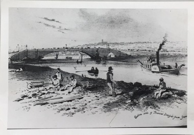 Kew Historical Society Inc
Photograph - Photograph (copy), S T Gill, Eastern side of Princess Bridge From Yarra, 1860-1880 (original)
... princess bridge -- river Yarra - melbourne (vic.)... the Yarra River at Princess Bridge, Melbourne.... reproductions -- s t gill princess bridge -- river Yarra - melbourne ...Copy of a painting (or etching) by S.T. Gill showing the Yarra River at Princess Bridge, Melbourne.Inscription reverse: "Eastern side of old Princess Bridge from Yarra"reproductions -- s t gill, princess bridge -- river yarra - melbourne (vic.) -
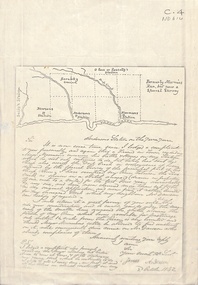 Whitehorse Historical Society Inc.
Document - Correspondence, Anderson's Station, 2/10/1842
... yarra river... of neighbouring runs bordered by the Yarra River.... ross station yarra river agriculture pioneers deep creek ...Photocopy of a letter from James Anderson dated 2 October 1842 complaining of incursions by stock of Major Newman on Anderson's adjoining land. Includes sketch map of relative locations of neighbouring runs bordered by the Yarra River.anderson, james, newman, (major), dawsons station, ross station, yarra river, agriculture, pioneers, deep creek, nunawading -
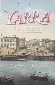 Kew Historical Society Inc
Book, Kristin Otto, Yarra: a diverting history of Melbourne's murky river, 2005
... yarra river - history...History of the Yarra River by Kristin Otto... History of the Yarra River by Kristin Otto melbourne - history ...245 p. : ill., bib., index, pbk ; 24 cm.non-fictionmelbourne - history, yarra river - history -
 Flagstaff Hill Maritime Museum and Village
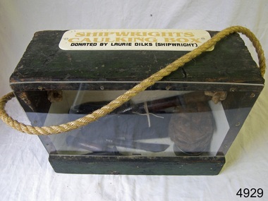
Equipment - Toolbox, Laurie Dilks, shipwright, Mid-to-late 20th century
... of the plumbing. Many decades later Laurie worked on the Yarra River...Port of Melbourne and Yarra River, Melbourne, Victoria... Laurie worked on the Yarra River moving barges up and down ...Caulking is a process used by shipwrights and other tradespeople to seal the gaps and cracks in boats and ships, buildings and plumbing fittings. It prevents water, air and pests from entering the through the gaps. The shipwright’s caulking box and a display of shipwright's tools are connected to the maritime history of Victoria through their past owner, user and donor, Laurie Dilks. Laurie began his career as a shipwright in the mid-1900s, following in the wake of the skilled carpenters who have over many centuries used their craft to build and maintain marine vessels and their fittings. Laurie worked for Ports and Harbours, Melbourne, for over 50 years, beginning in the early 1960s. He and a fellow shipwright inscribed their names on a wheelhouse they built in 1965; the inscription was discovered many decades later during a repair of the plumbing. Many decades later Laurie worked on the Yarra River moving barges up and down the river and was fondly given the title ‘Riverboat Man’ His interest in maritime history led him to volunteer with the Maritime Trust of Australia’s project to restore and preserve the historic WWII 1942 Corvette, the minesweeper HMAS Castlemaine, which is a sister ship to the HMAS Warrnambool J202.The shipwright’s caulking box containing caulking tools is an example of the equipment used by shipwrights in the early to mid-20th centuries. This box is connected to the maritime history of Victoria through its past owner, user and donor, Laurie Dilks. Laurie began his career as a shipwright at Ports and Harbours in Melbourne in the mid-1900s, following in the wake of the skilled carpenters who have over many centuries used their craft to build and maintain marine vessels and their fittings.Shipwright's caulking box, green wooden exterior with green and cream interior. Box has a Perspex face. A rope handle, knotted on each end, extends from one side to the other. A white rectangular plaque with rounded corners is screwed to the top and has yellow and black printed text. The donor was shipwright Laurie Dilks.Printed on plaque "SHIPWRIGHTS / CAULKING BOX / DONATED BY LAURIE DILKS [SHIPWRIGHT]'"flagstaff hill, flagstaff hill maritime museum and village, warrnambool, maritime museum, maritime village, great ocean road, shipwreck coast, caulking tools, caulking equipment, caulking box, shipwright's tools, laurie kilks, ports and harbours -
 Kew Historical Society Inc
Photograph - Yarra at Kew, 1925
... kew (vic.) — yarra river... in our collection. This photograph is of the Yarra River at Kew.... christian (1886-1962) landscape photography kew (vic.) — yarra river ...Henry Beater Christian (1886-1962) , was a descendant of one of the earliest settler families in Kew. Employed at the Kew Asylum as a 'public servant', he was a skilled amateur photographer, photographing numerous scenes in Kew and on his travels around Victoria. The majority of his photographs date from 1916 to 1929. His finest photographs are housed in two photograph albums. Digital copy of a photograph from page 4 of the 47-page photograph album containing 261 gelatinous silver images, loaned by Diane Washfold with permission given to digitise and hold a copy in our collection. This photograph is of the Yarra River at Kew."Yarra at Kew"henry beater christian (1886-1962), landscape photography, kew (vic.) — yarra river, christian-washfold collection, photograph albums -
 University of Melbourne, Burnley Campus Archives
Photograph - Black and white print, Aerial View of Burnley Campus C.1970, c. 1970
... yarra river... in bend of Yarra River after alterations to the position... Boulevard Richmond melbourne burnley campus aerial view yarra river ...Colour photograph of black and white photograph. Aerial View of Burnley Campus. Enlargement. Shows position of Campus in bend of Yarra River after alterations to the position of the river due to building of Freeway, new ovals and Richmond Public Golf Course.burnley campus, aerial view, yarra river, richmond public golf course -
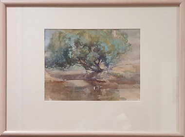 Federation University Art Collection
Painting - Watercolour, McGeorge, Norman, Untitled, c mid 1940s
... yarra river... Creek and the Yarra River. Purchased by the Ballarat Teachers... landscape darebin creek yarra river ballarat teachers' college art ...Norman MacGEORGE (08 July 1872– 2 September 1952) Born Adelaide, South Australia Norman Macgeorge taught drawing at Wesley College, Melbourne from 1902-06. He also taught at Melbourne Teachers' College and at Melbourne Church of England Grammar School. This item is part of the Federation University Art Collection. The Art Collection features over 2000 works and was listed as a 'Ballarat Treasure' in 2007.Framed landscape depicting the confluence of the Darebin Creek and the Yarra River. Purchased by the Ballarat Teachers' College in 1964. This work was exhibited in "Norman MacGeorge: Man of Art" at the Ian Potter Museum of Art, The University of Melbourne, 22 September to 25 November 2001.art, artwork, norman mcgeorge, mcgeorge, watercolour, available, landscape, darebin creek, yarra river, ballarat teachers' college art collection -
 Kew Historical Society Inc
Photograph - Wurundjeri People at Studley Park
... yarra river... of the Wurundjeri Woi Wurrung on the banks of the River Yarra, allegedly... River originally known as the Yarra Yarra / [illegible part word... yarra river aboriginal and torres straight islander Various ...The Wurundjeri Woi Wurrung People were the original owners of the land on which the City of Boroondara is now located. They made active use of the Yarra for food and transport [an original canoe is held in the collection of the Melbourne Museum]. From 1863, members of the Wurundjeri Woi Wurrung were resettled at the Corranderrk Aboriginal reserve at Healesville. The [now] best known member of the Wurundjeri People was William Barak, who may be pictured here.If the attribution in the annotation is correct, then this may be the earliest photograph of members of the Wurundjeri People at Kew. The photo may be unique.Hand tinted photograph on mounting card of members of the Wurundjeri Woi Wurrung on the banks of the River Yarra, allegedly at Studley Park before 1855 [according to the annotation on the reverse] The photograph of the river and its near and far banks includes two boats on the river, a row boat and a canoe, and people standing on the near bank or seated on the branch of a tree. In addition to men and women of the Wurundjeri People, there appears to be two Europeans pictured, one wearing a hat and the other standing at right. Annotations on the reverse identify a [possible] location and date. [Size: Mount 140 x 215mm | Photograph 125 x 190mm]Various hands and dates: "Original lead pencil lettering Studley Yarra Yarra / Yarra Yarra Studley / Studley (Park?) / Note aboriginals in a bark canoe / Prior 1855 / Very early photo Yarra River originally known as the Yarra Yarra / [illegible part word in ink]".wurundjeri woi wurrung, yarra river, aboriginal and torres straight islander -
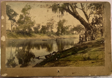
 Eltham District Historical Society Inc
Negative - Photograph, Tom Prior, Friars Falls, Eltham, c.1910
... yarra river...Friars Falls is near Griffith Park, Eltham on the Yarra... photograph collection eltham friars falls griffith park yarra river ...Friars Falls is near Griffith Park, Eltham on the Yarra RiverThis photo forms part of a collection of photographs gathered by the Shire of Eltham for their centenary project book,"Pioneers and Painters: 100 years of the Shire of Eltham" by Alan Marshall (1971). The collection of over 500 images is held in partnership between Eltham District Historical Society and Yarra Plenty Regional Library (Eltham Library) and is now formally known as the 'The Shire of Eltham Pioneers Photograph Collection.' It is significant in being the first community sourced collection representing the places and people of the Shire's first one hundred years. The Reynolds family were early settlers in Research. The Reynolds/ Prior collection of photographs were taken by Tom Prior, the maternal uncle of Ivy Reynolds, around 1900 and the 60 photos in the album give a fine overview of many of the landmarks of Research and Eltham over 100 years ago. lvy lived in the family home for many years at 106 Thompson Cres Research. Ivy's father, Ernst Richard Reynolds and grandfather, Richard Reynolds, lived at the same address. Ivy's father Richard worked for Mr. Trail on his property in Research. Reynolds Road is named after the family. Mr Tom Prior (wife Eva) worked at the Melbourne zoo. He was very innovative and made his own camera, using the black cloth hood to exclude the light. The photographs are a reminder of the rural nature of Research and Eltham and its rich heritage.Digital image 4 x 5 inch B&W Negshire of eltham pioneers photograph collection, eltham, friars falls, griffith park, yarra river, reynolds prior collection -
 Melbourne Tram Museum
Postcard, Traveller's Notes, 4 panel full colour - by Traveller's Notes, 1997
... Yarra River..., of the Yarra River, Cook's Cottage, Flinders St Station main entrance... Trams tramways Flinders St Station Yarra River SW6 class Route 5 ...Postcard - 4 panel full colour - by Traveller's Notes, of the Yarra River, Cook's Cottage, Flinders St Station main entrance, and SW6 852, University, route 5. Divided back, published by Traveller's Notes, photos by Neil J Leed, 1997.trams, tramways, flinders st station, yarra river, sw6 class, route 5, tram 852