Showing 553 items
matching 160
-
 Moorabbin Air Museum
Manual (Item) - Piper Pa-24 Comanche Parts Catalogue
Description: 753 586. Published June 1961, latest revision: July 1967. Published by Piper Aircraft Corporation. 150 pages. Piper Cherokee (PA-28-140/PA-28-150/PA-28-160/PA-28-180/PA-28-235/PA-28R-180) Aircraft Service Manual Level of Importance: World. -
![Book: SACS class of 1991-1996: Multicultural Women: [student stories]](/media/collectors/4fac93a2023fd71f703efeec/items/51ad36122162ef037c920ee3/item-media/51ad77c42162ef0ab4ba46bd/item-fit-380x285.jpg) NMIT (Northern Melbourne Institute of TAFE)
NMIT (Northern Melbourne Institute of TAFE)Book: SACS class of 1991-1996: Multicultural Women: [student stories]
A4 size bound books consisting of student writings produced in the Certificate of Occupational Studies: Social & Community Services Course run by Northern Metropolitan College of TAFE at the Migrant Women's Learning Centre based at the Collingwood campus. Copies held 1991 (100 pages0, 1992 (176 pages), 1994 (160 pages) which has the added title 'Turning Point', 1996X 2 copies.northern metropolitan college of tafe, social & community services course, migrant women's learning centre, students, nmit -
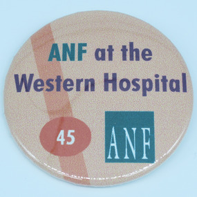 Australian Nursing & Midwifery Federation
Australian Nursing Federation/Western Hospital delegate/member badge, [1990s-2000s?]
Button distributed to and worn amongst Australian Nursing Federation members employed at Western Hospital (now Footscray Hospital). Possibly worn only by delegates/union representatives at this workplace, and/or celebrating 45 years of the Western Hospital (this occurred in 1998). The Western Hospital changed its name to Footscray Hospital in July 2014 and is located at 160 Gordon St, Footscray, Victoria, Australia.Circular orange/red badge with blue writing and logo. Silver metal, plastic-coated, with safety pin fastener adhered to back. Badge printed with 'ANF at the Western Hospital' the number '45' and the ANF [Australian Nursing Federation] logo.nursing, nurses, badges, buttons, pins, western hospital, western health, footscray hospital, melbourne, victoria -
4th/19th Prince of Wales's Light Horse Regiment Unit History Room
Radio Installation
Installation as used by the Regiment in M113 family of vehiclesRadio Installation AN/VRC 46, AN/GRC 160, AN/VIC1(V) Harness. VHF radio installation as used in M113 family of vehicles. Consists of two mounting trays MT1029?VRC, one radio RT841/PRC77, one amplifier AM2060/GRC radio installations and the harness - AM 1780/VRC, three C2298 control boxes, one C2299 rebroadcast box, various cabling and two antenna systemsRT 524 - No 58347 RT841/PRC 77 - No 1835. AM2060GRC - No 660. AM1780/VRC - No 4841. Antenna Matching Units - Nos 94784 & 13050 radio installations, m113, armour -
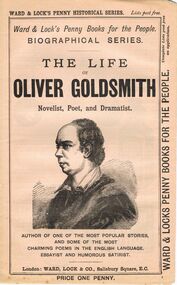 Bendigo Historical Society Inc.
Book - LYDIA CHANCELLOR COLLECTION: THE LIFE OF OLIVER GOLDSMITH
A book titled ' The Life of Oliver Goldsmith novelist, poet and dramatist. Author of one of the most popular stories and some of the most charming poems in the English language. Essayist and humorous satirist.' London : Ward, Lock & Co., Salisbury Square, E.C. 145 - 160 pgs. This booklet is one of a series of 53 ' Ward & Lock's Penny Books for the People.' 'Biographical Series.' Price one penny. There are advertisements of note.books, biography, oliver goldsmith, lydia chancellor, collection, oliver goldsmith, person, individual, famous people, male, penny books, ward & lock's penny historical series, biographical series, ward & lock's penny books for the people, novels, poets, poetry, drama, english literature, sartire, advertisements -
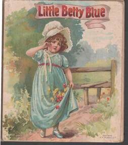 Bendigo Historical Society Inc.
Book - CHILD'S BOOK DORIS EMMETT PRESENTATION: LITTLE BETTY BLUE
Child's book -' Little Betty Blue ' / cardboard cover with watercolour painting of young girl - cloth binding / 'London Ernest Nister , Printed in Bavaria 160 , New York E.P.Dutton & Co / first page written in ink - ' Private School Wattle St , Upper first class prize for home lessons awarded to Doris Emmett, Christmas 1903 , A.L Parckhurst Teacher / collection of Nursery RhymesErnest Nister , E.P.Dutton & Cobooks, children's, story book, little betty blue / ernest nister / e.p.dutton & co / private school wattle st , /, a.l parckhurst teacher / doris emmett -
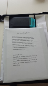 Peterborough History Group
Memorabilia - 160th Anniversary Schomberg Satchel, Peterborough History Group, 2015
Items created for the anniversary of the wreck of the Schomberg and displayed in the Peterborough Hall as part of the anniversary celebrations. Sea Shanty lyrics include a reference to Bully Forbes, Captain. All Schomberg information pertains to display and presentation at the time of the anniversary of the shipwreck celebration in 2015.Plastic zipped satchel containing collected information about the wreck of the Schomberg, created for the 160 year anniversary of the wreck of the Schomberg. Items included are: transcription of the diary of James Hopkins journey on the Schomberg; transcription of the diary of Thomas Angove, passenger on the Clipper ship the Schomberg; 14 large print pages summarising the story of the Schomberg and including lyrics of Blow Boys, Blow, a halyard sea shanty; Ron Cashmore's input.James Hopkins original diary held in the UK, this copy for display by he Peterborough Residents Association, Peterborough History Group. Thomas Angove original diary held in the UK, this copy for display by he Peterborough Residents Association, Peterborough History Group.rex mathieson, ron cashmore, bully forbes, schomberg rock, peterborough 3270, the schomberg, schomberg-shipwreck, shipwreck, sea shanty, captain bully forbes -
 Bendigo Historical Society Inc.
Document - NEVILLE KING COLLECTION: OCCUPATION CERTIFICATE HOMESTEAD FARM NO. 15/939 IN THE NAME OF DAVID WILLIAMS AT A COST OF ONE POUND, DATED 25 SEPTEMBER 1897, 1897
Under the Western Australia 'the Homestead act 1893' an Occupation Certificate, Homestead Farm No. 15/939 for David Williams of Bendigo for 160 acres (near Woolkabunning near Bunbury WA); at a cost of one pound. Signed by order of the Commissioner of Crown Lands. Dated 25 September 1897. The land is marked and distinguished in the maps and books of the Department of Lands and Surveys of the said (WA) Colony as Williams Location No. 702. -
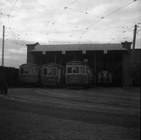 Melbourne Tram Museum
Negative, Wal Larsen, c1950
Black and white negative, of R class 174 (Lyon St), S class 160 (Thornbury), SW5 class 842 route 65 & W2 class 320 (Nth Fitzroy, route 11) at Thornbury depot, c1950. Photo not in Wal Jack Melbourne album. Neg was in a Bright Methodist Church offering envelope - stored with negative file. - has 1949 in pencil on the envelope. Wal Larsen was a Bright resident.trams, tramways, s class, w2 class, thornbury depot, tram 174, tram 160, tram 842, tram 320, r class, sw5 class, mmtb -
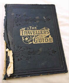 J. Ward Museum Complex
Book - Religious Text, The Traveller’s Guide from Death to Life - Editor: Mrs. Stephen Menzies
Religious text used in Victoria's mental institutionsA good example of the texts relating to Protestant Missions in the late 1800s18.5 cm x 25 cm. 160 pages. Hardcover [publisher’s original navy blue pebbled-finished cloth]. Gilt-stamped device with title and black tooled borders on front board. Blind border tooling to rear board. Fair condition with some significant signs of external wear. Faded and torn cloth at spine. Binding relatively firm and solid. Sharp cornered interior clean and with some aging. Tricoloured Bookplate carrying “Sin, Subsitution, Salvation” and similiarly themed quotes. bible, biblical commentary, protestantism, religious literature -
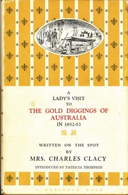 Bendigo Historical Society Inc.
Book - THE GOLD DIGGINGS OF AUSTRALIA, c1963
A Lady's Visit To The Gold Diggings Of Australia In 1852-53. Written on the spot by Mrs. Charles Clacy Introduced by Patricia Thompson. Publisher Lansdowne Press, Tattersall's Lane, Melbourne. Edition: Second. 160 pages. One illustration.. Inscriptions/Markings: underlining in red and black on many pages, some notes. Harold Curnow 19/8/64 written in the front. Bendigo Historical Society stamp in front and back covers.Mrs. Charles Clancybook, gold diggings of australia, gold diggings -
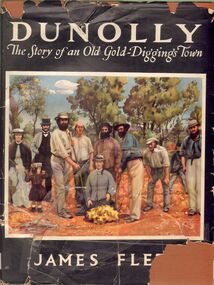 Bendigo Historical Society Inc.
Book - ALEC H CHISHOLM COLLECTION: ''DUNOLLY, THE STORY OF AN OLD GOLD-DIGGINGS TOWN''
Book. ALEC H CHISHOLM COLLECTION. 160 page hardcover 'coffee table' book on the history of the gold rushes at Dunolly and surrounding district by James Flett. Includes 7 maps and 41 illustrations. Published in 1956 by the Poppet Head Press and printed by George H Barrow & Co., Melbourne. Catalogue sticker ''2256 FLE'' on spine. Coloured copy of the photo of the discovery of the 'Welcome Stranger' nugget at Moliagul in 1869 opposite title page.James Flettbooks, collections, history, alec h chisholm collection, james flett, dunolly, gold rush -
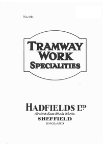 Ballarat Tramway Museum
Book, Hadfield's, "Points, Crossings and Special Track Work for Tramways & Railways, c1910
160 page book with heavy covers, with title "Points, Crossings and Special Track Work for Tramways & Railways / Hadfield's Steel Foundry Co. Ltd., Sheffield England" giving details with many photographs of the company and their work in producing cast steel points and castings for Railways and Tramways. Shows many photos of the layout of complex junctions in their Sheffield works at East Hecla. Has many fine detailed engravings. Images added 24-12-2016"Ballarat Tramway Preservation Society Catalogue No. 4" on page 1.trams, tramways, trackwork, hadfield's, special work, cast steel -
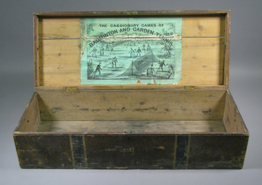 Tennis Australia
Chest, Circa 1876
An empty chest, originally housing a lawn tennis and badminton set. Black and green lithographic print features couples playing mixed doubles tennis and badminton in Cassiobury Park, with Cassiobury House in the background. Inscription: THE CASSIOBURY GAMES OF/BADMINTON AND GARDEN TENNIS/LONDON/DEAN & SON 160 FLEET STREET. The hourglass court used in Wingfield's version of lawn tennis is depicted in this lithograph. Materials: Wood, Metal, Ink, Glue, Paint, Paper, Lacquertennis -
 Bendigo Historical Society Inc.
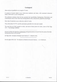
Document - MINING REPORTS - GEOLOGICAL REPORT OF MAIN SECTION OF GOLDFIELD
Handwritten notes by Albert Richardson, with typed copy, on a Geological report of main section in a length of 5 miles. Report mentions sandstones and slates, with occasional calcareous bands, which show a cyclic arrangement. Also mentioned are different zones of sediments, anticlines, structure of the field and references: Page 1028 Formation of Bendigo Quartz Reefs by F R Stilwell to 1032 and pages 160 to 163 'Ore deposits as Related to Structural Features - A H Newhouse. document, gold, mining reports, mining reports, geological report of main section of goldfield, the bendigo goldfields page 1015, formation of bendigo quartz reefs by f r stilwell page 1028 to 1032, ore deposits as related to structural features pages 160 to 163 a h newhouse -
 Orbost & District Historical Society
book, Broadbent's Melbourne - Sydney Guide Book, 1936
Broadbent's Official Road Guides Company took over George R. Broadbent's business in 1935. In 1963, it changed its name to Broadbent's Road Maps Pty. Ltd. George Robert Broadbent (1863-1947), cyclist and map publisher, was born on 3 November 1863 at Ashby near Geelong, Victoria. At various times Broadbent held most Victorian and Australian road cycling records. Broadbent became an active vice-president of the Good Roads Association of Victoria in November 1912 and was consulted regularly during the preparation of the country roads bill. That year he took over the Argus motoring column, wrote tirelessly on road improvements and maintenance, and became manager of the Automobile Club's new touring department in 1914.A 160 pp road guide book titled Broadbent's Official Road Guide Melbourne - Sydney. The front cover has a yellow background with a map of the coastline from Sydney to Melbourne, the Prince's Highway route marked. This is inset in a drawing of a car driving along the coastal road.The book contains speedometer readings, route maps, advertisements and photos of points of interest. In the top right is the logo of the Royal Automobile Club of Victoria and at the bottom right is the price 1/-.traavel road-guides broadbent-george car-touring -
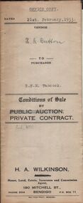 Bendigo Historical Society Inc.
Document - H.A. & S.R. WILKINSON COLLECTION: CONTRACT OF SALE
Conditions of sale by private contract dated 21st February, 1933 between H.G. Button (seller) and B.E. M. Tancock for land situate 31 Creel Street, Bendigo being part of Crown allotment 31 section 127C described in certificate of title volume 2313 folio 462535, together with 5-roomed weatherboard and brick dwelling, at present occupied by Mr. Malkin as tenant, and all sundry outbuildings on the said land. Price 160 pounds.organization, business, h.a. & s.r wilkinson real estate -
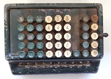
The Ed Muirhead Physics Museum
SUMLOCK Adding Machine
keys: 12 Plaque: ‘Supplied by Bell Punch A’sia Ltd / 160 Castlereagh St., Sydney / 27 Little Collins St., Melbourne / Agents and Services in all states / BPC / Cash Control Systems, Adding Machines, Ticket Registers, Charge Machines / Ticket Printers, Gum Tape, Scaling Machines etc. /’ good working condition -
 Wodonga & District Historical Society Inc
Functional object - Adding Machine - J. Mann & Sons, Bell Punch Co. Ltd, 1950s
J. Mann and Sons was first established as a farm produce store in 1921. The range of products was extended in the 1930s and included groceries and hardware, as well as the first petrol bowser in Wodonga outside the store. After WWII, the premises were extended and the range of products continued to increase. In the 1960s the Mann Family opened a new supermarket in Wodonga, in addition to the hardware business, providing steel, plumbing and industrial supplies, and they employed over 100 people at one stage. With changes in the retail industry, the Mann Family sold the main hardware business to Bunnings and the steel and rural produce business to the Kelly brothers in 2006. Bell Punch A/sia Ltd was a subsidiary of The Bell Punch Company, itself a part of (Cash) Control Systems. The Bell Punch Company was a British company manufacturing a variety of business machines, including several generations of public transport ticket machines and the world's first desktop electronic calculator The company was founded on 5 July 1878. By 1961 it employed a workforce of 2000 people. The circular mark on the back of the machine was adopted in the 1950s.On Back of machine: Supplied by BELL PUNCH LTD. A/SIA BPC CASH CONTOL SYSTEMS 160 CASTLEREAGH ST. SYDNEY, MA9337 427 LITTLE COLLINS ST. MELBOURNE. CENT. 2038 AGENTS AND SERVICE IN ALL STATES ADDING MACHINES TICKET REGISTERS CHANGE MACHINES TICKET PRINTERS GUM TAPE SEALING MACHINES, ETC.j. mann & sons, vintage adding machines, bell punch australasia -
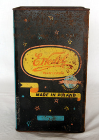 Orbost & District Historical Society
confectionery tin, C 1950's
Wedel is the oldest chocolate brand in Poland. It has been operating for over 160 years. Beginning with Karol Ernest Wedel, his son, Emil and followed by Jan Wedel the Wedel family waswell known for its social welfare policies. During WW11 Jan Wedel refused to collaborate with the the German government leading to persecution of his employees and his family. Although the company has been taken over several times by larger international groups, the Wedel name remains part of the product.A large tin container which held confectionery. The front of the tin has a black background , decorated with yellow,blue and red stars. In the centre is the Wedel logo, a signature on a yellow oval background.on front - E. Wedel Rolimpex Made in Poland, Warsaw Sole exportercontainer e-wedel confectionery -
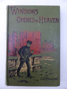 Warrnambool and District Historical Society Inc.
Book, Windows opened in Heaven - I S Rankin 1904, Early 20th century
This book has been given as an end-of-year prize to someone in the Warrnambool Corps in 1904. As the book is for a young person it is presumed that the recipient was in the Cadet Corps section of the local Volunteer Corps. Members of the Cadet Corps were usually from a unit formed within a school. As neither the Warrnambool Agricultural High School nor the Warrambool Technical School were established at that time the recipient was probably a pupil at a private boys’ school. This book is of interest as a prize given by the Warrnambool Corps to a local Warrnambool boy in 1904. It will be of greater interest if we can decipher the name of the Sergeant-Major and the name of the recipient. This is a hard cover book of 160 pages. It has an olive-green cover with an image in red, black and yellow of a young boy in front of some buildings. The front cover has black and red lettering and the spine has an image of a woman and the lettering in gold and red. The book has a full page black and white illustration at the front of the book and there are 18 chapters of text. There has been a book plate pasted on to the inside cover but there is now only a fragment left. What is visible is handwritten in black ink. ‘….. Serg.-Major, Warrnambool Corps, Dec. 13th 1904’. warrnambool corps, warrnambool cadet corps, history of warrnambool -
 Kew Historical Society Inc
Map, MMBW, MMBW Plan No.64 Kew & Heidelberg, 1900-1910
The Melbourne and Metropolitan Board of Works (MMBW) was established by an act of the Victorian Parliament in 1890 to prepare for and to implement a sewerage and water reticulation system across what was then inner Melbourne, its surrounding and middle distance suburbs, including Kew. The MMBW was disbanded in 1991.The map collection of the Kew Historical Society has at its core the historic maps assembled and originally stored in the City Engineer's Department of the City of Kew. These include maps in a number of scales. The vast majority of maps were produced by the MMBW in the first two decades of the twentieth century, and are solid working maps, backed by linen for durability. These maps are historically significant to Kew, the City of Boroondara and to the history of the development of state utilities in Victoria. A number of the Kew maps have additional details added by former municipal officers, including the levels reached by various floods. As these were working documents, information was added to them long after the period of their initial production and distribution.Early map of part of the Borough of Kew, created in the first decade of the twentieth century, at a scale 160 ft to 1 inch. The map covers what was then the northern most part of Kew, bordered on its north and west by the Yarra River, in the East by Connor's Creek and by the Asylum in the south. The map shows the extent of urban development by that time, prominent institutions and the outlines of built structures in the municipality. Contour lines and historic flood levels were added in ink to the map at a later stage.MELBOURNE AND METROPOLITAN BOARD OF WORKS / PLAN NO. 64 / KEW & HEIDELBERGmelbourne & metropolitan board of works, mmbw maps, mmbw plans, borough of kew, cartography -
 Kew Historical Society Inc
Map, MMBW, MMBW Plan No.65 Kew & Heidelberg, 1900-1910
The Melbourne and Metropolitan Board of Works (MMBW) was established by an act of the Victorian Parliament in 1890 to prepare for and to implement a sewerage and water reticulation system across what was then inner Melbourne, its surrounding and middle distance suburbs, including Kew. The MMBW was disbanded in 1991.The map collection of the Kew Historical Society has at its core the historic maps assembled and originally stored in the City Engineer's Department of the City of Kew. These include maps in a number of scales. The vast majority of maps were produced by the MMBW in the first two decades of the twentieth century, and are solid working maps, backed by linen for durability. These maps are historically significant to Kew, the City of Boroondara and to the history of the development of state utilities in Victoria. A number of the Kew maps have additional details added by former municipal officers, including the levels reached by various floods. As these were working documents, information was added to them long after the period of their initial production and distribution.Early map of part of the Borough of Kew, created in the first decade of the twentieth century, at a scale 160 ft to 1 inch. The map covers what was then the south central part of Kew, bordered on its north by Malmsbury Street, in the west by Florence Avenue, in the south by Barkers Road, and in the east by Princess Street. The map shows the extent of urban development by that time, prominent institutions and the outlines of built structures in the municipality. Contour lines were added in ink to the map at a later stage.MELBOURNE AND METROPOLITAN BOARD OF WORKS / PLAN NO. 65 / KEW & HEIDELBERGmelbourne & metropolitan board of works, mmbw maps, mmbw plans, borough of kew, cartography -
 Kew Historical Society Inc
Map, MMBW, MMBW Plan No.66 Kew, 1900-1910
The Melbourne and Metropolitan Board of Works (MMBW) was established by an act of the Victorian Parliament in 1890 to prepare for and to implement a sewerage and water reticulation system across what was then inner Melbourne, its surrounding and middle distance suburbs, including Kew. The MMBW was disbanded in 1991.The map collection of the Kew Historical Society has at its core the historic maps assembled and originally stored in the City Engineer's Department of the City of Kew. These include maps in a number of scales. The vast majority of maps were produced by the MMBW in the first two decades of the twentieth century, and are solid working maps, backed by linen for durability. These maps are historically significant to Kew, the City of Boroondara and to the history of the development of state utilities in Victoria. A number of the Kew maps have additional details added by former municipal officers, including the levels reached by various floods. As these were working documents, information was added to them long after the period of their initial production and distribution.Early map of part of the Borough of Kew, created in the first decade of the twentieth century, at a scale 160 ft to 1 inch. The map covers what was then the south eastern part of Kew, bordered on its north by Adeney Avenue, in the west by Sackville Street, in the south by Barkers Road, and in the east by Burke Road. The map shows the extent of urban development by that time, prominent institutions and the outlines of built structures in the municipality. Contour lines were added in ink to the map at a later stage.MELBOURNE AND METROPOLITAN BOARD OF WORKS / PLAN NO. 66 / KEW melbourne & metropolitan board of works, mmbw maps, mmbw plans, borough of kew, cartography -
Kew Historical Society Inc
Journal - Visitor Book, Fairyland Book
"Fairyland", the home of Jim and Grace Tabulo, was a notable local, state and international tourist attraction situated in Kew, Victoria during the mid twentieth century. Located at 57 Malmsbury Street, Kew, the weatherboard house and its garden were heavily decorated with statues, crockery and other collected items. A series of notebooks were used to record the messages of child and adult visitors to the property from the 1940s to the 1960s. After Mrs Tabulo's death, these visitor books are believed to have formed part of the Dorothy Rogers Collection. They entered the Kew Historical Society's collection following Dorothy Roger's death in 1973.This series of visitor books are the most important primary sources relating to the internationally renowned 'Fairyland' cottage in Malmsbury Street, Kew. Their social significance is that they record in the post war period the values and beliefs of children and adults who visited this historically significant tourist attraction.Foolscap size visitor book containing handwritten comments and drawings primarily made by children during visits to the home of Grace Tabulo, c.1950-1960. Commonly known as "Fairyland", the house was located at 57 Malmsbury Street Kew. The book is wrapped in brown paper, which covers back cardboard covers with a red cloth strip binding. Unpaginated, approximately 160 pages, and covers. The book has an additional loosely inserted black card cover located at the front of the book.Handwritten in pencil on paper cover: "1950 - 1962 /(edit book dates)" Handwritten in ink on paper label on loosely inserted cover: "Fairy Land / Book/ September 1950 / Fairy Land / Book / 75 [sic] M...berry [indistinct] st Kew / Fairy Land Book"grace tabulo -- fairyland -- 57 malmsbury street -- kew (vic.), tourism - kew - 1945-1965, childhood - kew, collectors and collecting, gardens - kew (vic), scrapbooks - 20th century -
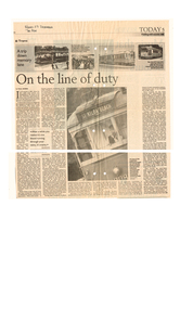 Melbourne Tram Museum
Newspaper, The Age, "On the line of duty", 17/12/1999 12:00:00 AM
Newspaper clipping from the Age, 17 December 99, titled "On the line of duty", written by Paul Norris, based on research and content from Tram People (1999, Norris Media Productions, a 160 minute video documentary produced and directed by Norm Morris". Includes interviews with Norm Cross, Mario Sirianni, Graham Jones, along with photos of cable trams, W7 and a Z class tram. The year of the cutting - 1999 - has the letters "99" in the top left hand corner.In top left hand corner, "Friday 17 December The Age"trams, tramways, yarra trams, films, tram crews -
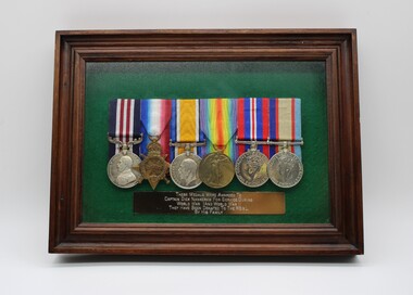 Beechworth RSL Sub-Branch
Award - Court Mounted Medals
This original set of medals and memorabilia were donated/bequeath to the Beechworth RSL Sub-Branch by Captain Nankervis’ family. The inscription on the framed box containing the Medal Bar reads, “These medals were awarded to Captain Dick Nankervis for service during World War I and World War II. Part of the Nankervis Collection, there is a lengthy word document in the Media Section6 Court Mounted WWI and WWII medals; laid on green felt, in a wooden display case Measuring 300mm x 220mm with non reflective glass front and metal bar with an engraved inscription Metal Bar measuring 20 x 160 mm engraved with "This original set of medals and memorabilia were donated/bequeath to the Beechworth RSL Sub-Branch by Captain Nankervis’ family. The inscription on the framed box containing the Medal Bar reads, “These medals were awarded to Captain Dick Nankervis for service during World War I and World War II". wwi war medals, wwii war medals, rack of six medals, military medal -
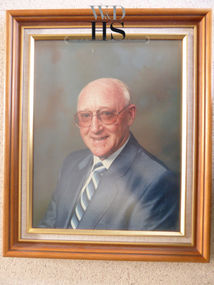 Warrnambool and District Historical Society Inc.
Photograph - Don Jenkins - Woollen Mill
Don Jenkins was the Managing Director of the Warrnambool Woollen Mill from 1971 to 1989. He was first employed at the Woollen Mill in 1935. The Warrnambool Woollen Mill in South Warrnambool was established in 1910 with the first manager, J.E. Bennett. By 1915 there were 160 employees and in 1969 there were 380 employees. In 1980 acrylic blankets and fabrics were made on the site and in 1982 there was a name change to Warrnambool Textiles. In 1995 the Smith Family took over the factory, following its ownership by several other Australian firms. It closed in 2000. This is an important photograph as the Warrnambool Woollen Mill was a prominent business in Warrnambool for 90 years. Don Jenkins was the Managing Director for 19 years and this is a good photograph of him and is very useful for display and research purposes. This is a colour photograph of Don Jenkins in a wooden and gilt edged frame with a linen insert. On back of photograph handwritten in biro – ‘Don Jenkins, Managing Director, 1970-1988?’ (Note that Mr Jenkins was the Managing Director from 1971 to 1989)warrnambool, woollen mill, don jenkins, manager warrnambool woollen mill -
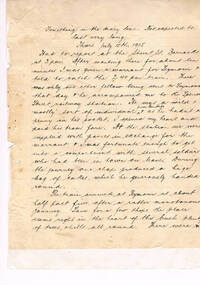 Warrnambool RSL Sub Branch
DIARY & LETTERS, from July 1915 to July 1919. TRANSCRIBED by Walter J R Barber). Bob's diaries and letters are mostly typed. Some letters were hand-written, in ink or pencil, on letter-headed paper. Page1 of Bob's original diary. 3 sample letter-heads
This collection of Bob Snape's diary and letters was transcribed because of the large body of material. 55 numbered letters (out of some 160 plus) survive. Many letters were typed. As a clerk in HQ, Bob had constant access to a type-writer, and sometimes said to his family that typing was much more efficient for him than writing by hand. There are many letters in hand-writing, some in ink , others in pencil. Some letters are on letter-headed paper, eg: YMCA, TSS (HMAT) 'Demosthenes', hotels, family in Wales.snape collection -
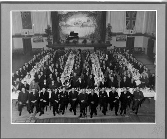 Victoria Police Museum
Photograph (Victoria Police), Police Officers on dinner event, February 1945
[see inscriptions] Black and white mounted photograph. Approximately 160 men (171 according to inscription on the back) sitting on large tables at a formal dinner event; all weatinh suits and posing for photograph. Photo was taken in a large rooom with a stage, Malvern Town Hall accoring to inscriptions on the back - tables occupy centre and front of photograph - but in the background: [left] Australia flag, WWII poster; [center] stage with painted landscape and piano; [right] WWII poster and Britain flag. [information of event on newspaper cutting stuck on the back - as described on Inscriptions]Handwritten: 171 PRESENT // FEB 1945 // (?) OFF SUPT KNOTT // INSPT SAMBLEBE // CONST GRAMBEU /// MALVERN TOWN HALL Newspaper cutting glued to frame: Supt. J. R. H. Knott, has rettired from the Police Force after 38 and half years' service, was farewelled by citizens and police officials at Malvern Town Hall on Tuesday night, The mayor of Malvern (Cr. J. Johnson) presided and presented SUpt. Knott with a chair and a wallet of notes. Similar presentations were made to Inspector C.H.D. Samblebe and First Constable O. Grambau, who have also retired. Supt. A.D. McKinnon of Ballarat will succeed Supt. Knott // handwritten: SUN 1/2/45victoria police museum, police officers, police academy, police force, superintendent mckinnon, superintendent knott, cr johnson, inspector samblebe, first constable grambau, poulter, william