Showing 15878 items
matching areas
-
 Whitehorse Historical Society Inc.
Document, Shirley Paramanathan (Ellams), 2008
Shirley arrived with her family as a 'Ten pound Pom' in 1955.Shirley arrived with her family as a 'Ten pound Pom' in 1955. She gives her impressions of the area, especially Nunawading and Forest Hill. Notes of an interview by Lesley Alves for 'Suburban heartland'Shirley arrived with her family as a 'Ten pound Pom' in 1955. paramanathan, shirley, clifford court, forest hill, ellams family, alves, lesley. suburban heartland, cornelius, shirley, luckie street nunawading -
 Otway Districts Historical Society
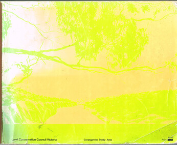
Book, Land Conservation Council, Report on the Corangamite Study Area, May 1976
The Report describes and assesses the natural resources of public land in the Corangamite study area, and provides a factual basis on which members of the community may base their submissions to the Council.Report on the Corangamite study area. Land Conservation Council. Melbourne; Land Conservation Council; May 1976. x, 310 p.; illus, maps (separate). Soft cover.land conservation council; corangamite; geology; physiography; climate; water resources; soils; vegetation; fauna; -
 Mt Dandenong & District Historical Society Inc.
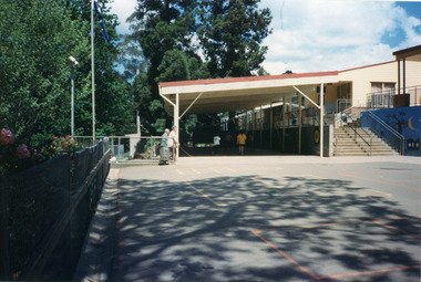
Photograph, Mount Dandenong Primary School 1997, 1997
The first Mt Dandenong State School opened in a shed on the property of William Ferguson on the corner of Blythe and Old Coach Roads. The first teacher was Miss Ethel Gruber who opened the school on May 11th, 1897. It wasn’t until 1901 that the school shifted over the road into an old school building that was moved up to the new site from Ringwood. All the buildings were demolished to make way for a new school that opened in 1991. Looking across from asphalted area to the 'undercover area' November 1997.mount dandenong, mt dandenong school -
Whitehorse Historical Society Inc.
Document, Charles Edgerton, 1851 - 1908
Life history of Charles Edgerton.Life history of Charles Edgerton who purchased land in Edgerton Road, Mitcham from Carl Benno Schwerkolt in 1892 and an account of the 1905 bushfire in the area. Prepared by Anne Jones.Life history of Charles Edgerton.edgerton, charles, schwerkolt, carl benno, edgerton road, mitcham, jones, anne -
 Albert Park-South Melbourne Rowing Club
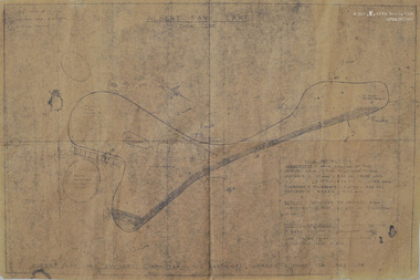
Map, Albert Park Lake, Post-1957
A dyeline-type map of Albert Park Lake and buildings.ALBERT PARK LAKE / 1" = 320 / TIME RESTRICTIONS / SPEEDBOATS HAVE FULL USE OF THE HATCHED AREA AT THE FOLLOWING TIMES / SUNDAYS - 12 NOON - 5.30PM RACE DAYS. / 2.30PM - 3.30PM ALL OTHER DAYS / TUESDAYS & THURSDAYS - 2.00PM - 4.00PM / SATURDAYS - 8.00AM - 11.00AM / ROWING - CONFINED TO WESTERN BANK / UNRESTRICTED TIME EXCEPT IN SPEEDBOAT AREA / YACHTS, HIRE BOATS - UNRESTRICTED TIME & AREA EXCEPT IN SPEEDBOAT AREA. / (CARE TO BE TAKEN IN ROWING AREA / IF POSSIBLE KEEP CLEAR) / RESTRICTED TIMES & AREAS FOR LAKE USEalbert park lake, rowing, apsm rowing club, map, albert park rowing club, south melbourne rowing club -
 Melbourne Tram Museum
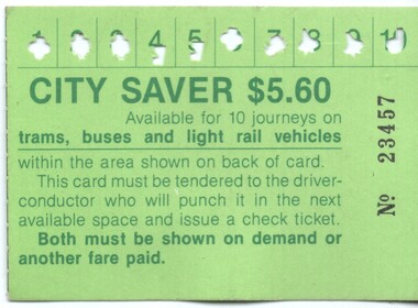
Ephemera - Ticket - City Saver, The Met, 1988c
Used by The Metropolitan Transport Authority (The Met) to provide a multi-journey trip ticket within a nominated City (CBD) area. Has been used for 10 trips. A check ticket was issued by a conductor for each trip made. Has details of the availability on the rear. Notes that the ticket is available for trams, buses and light rail. Previous issues did not have light rail listed. The light rail to St Kilda and Port Melbourne commenced in Nov. 1987. Has The Met logo on the rear. Demonstrates a multi-use ticket used by The Met in the City area of Melbourne.City Saver –No. 23457 - $5.60 printed on a green card with a map of the available CBD travel area on the back.public transport, tickets, the met, trams, tramways, city saver -
 Sunbury Family History and Heritage Society Inc.
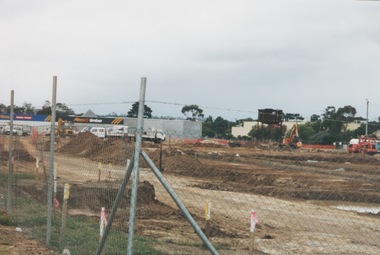
Photograph, 13 April 2000
In 2000 work commenced on the further development of railway land on the west side of Sunbury station for the construction of commercial and entertainment facilities. Prior to this time the land had been undeveloped and was often used to accommodate visiting circus troupes. Cereal storage silos also occupied this area for some time. The development of this area has been a reflection of the rapid expansion of settlement within Sunbury and surrounding areas that occurred during the early years of the twentieth century.A coloured photograph of a fenced off area undergoing development with earthmoving equipment and trucks in operation and some commercial buildings visible in the middle distance.sunbury railway station -
 Kiewa Valley Historical Society
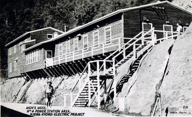
Postcard Circa 1950, Men's Mess No.4 Power Station, Kiewa Hydro-Electric Project
This postcard was produced in the 1950's for the tourist trade in the Kiewa Valley and Alpine region. It encompasses the period when the State of Victoria was pressured by the ever increasing demand by industry and its population for electricity supplies. Hydro electricity was seen as an untapped natural resource to quench this demand. The Victorian Alps and the rivers flowing into its valleys was ideal for the construction of the Kiewa Hydro Electricity Scheme. The late 1940's saw the development of this scheme and the changing of sections of alpine landscape is covered by this and other postcards/pictures (tourists, construction workers, and established rural populations). This period in time was before the established wildlife and forest/nature groups became political activist who changed legislative acts to protect the environment.Although this photo details the eating facilities of the construction workers at the power station it was not only a postcard for the people employed in the Hydro Scheme is was also provided to tourists visiting the area and thus used for promotional purposes.This rural region (Kiewa Valley/alpine plains) was at most only significant to a smaller group of winter sports, summer hikers/horse riders and rural farmers/graziers. The numbers of tourists and the increase in the local resident population was boosted by the construction of the Hydro Electricity Scheme. This influx to the regional population resulted in a corresponding diversity in services and brought about an environment that responded to a growing level of tourists and thereby permitting this industry to grow more rapidly than it would have naturally. This postcard details an attraction to the "cleaner" method of providing electricity. This postcard was purchased in 1950 by a surveyor at Landford's Gap. The men shown in this photograph would have been employed by the S.E.C. under the Kiewa Hydro-Electricity Scheme.This item is a scanned black and white photograph of a construction worker walking from stairs leading down from the men's mess building, in 1950. See 0480 (A) -(C), (E) - (F) for other photos of similar postcards"MEN'S MESS No.4 POWER STATION AREA, KIEWA HYDRO-ELECTRIC PROJECT" "ARGUS PHOTO V.IIkiewa valley tourism, victorian alps, alternate energy supplies, alpine population growth, secv -
 National Vietnam Veterans Museum (NVVM)
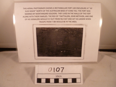
Photograph - Photograph, Suoi Nghe, 7RAR
A reprinted black and white Photograph of an area with a small rectangle area in the middle and the road goes down from below middle left side to near bottom on the right side. Above the photograph reads: This aerial photograph shows a rectangular fort like enclosure at "Ap Suoi Nghe" North of the Australian Base at Vung Tau. the fort was manned by Montagnard soldiers who lived with their families within the walls of the village. The RSO of 7 Battalion, John Methven, and one of his signalers would fly out from Nui Dat and act as liaison when troops from 7 BN would be in the area.This aerial photograph shows a rectangular fort like enclosure at "Ap Suoi Nighe" north of Australian base at Vung Tau. The fort was manned by montangard soldiers. They lived in the walls of the fort along with their families. The RSO of 7 Battalion, John Methven and one of his signalers would fly out from Nui Dat and act as liaison when troops from 7 BN woul be in the area.7 rar, 7 battalion map, john methven, montagnard, suoi nghe, signals -
 Federation University Historical Collection
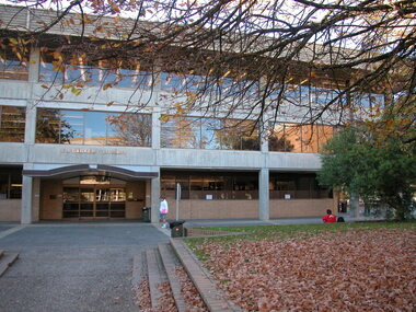
Photograph - Colour, E. J. Barker Library, Mount Helen Campus, Federation University Australia - 2006, 2006
Work began on the Library construction in 1968. This was when it was known as Ballarat College of Advanced Education - Mount Helen. The Library started on the ground floor in 1970. In 1971 a contract for a four-storey library was drawn up and construction began the same year. The building opened in 1973, occupying two stories of the current building. The library grew and with Commonwealth Grants was able to develop its collection. In 1987 the library achieved an annual budget of over $1 million. The Teachers Resource Collection was added and by 1989 the library expected to occupy the top three floors plus the lower ground floor. A flexible study area on the top floor was introduced 1990-1991. 2010 saw the completion of a new stage in the history of the library. It now includes new study and research areas including the Geoffrey Blainey Research Centre with access to the University's Art and Historical Collection. The E. J. Barker Library is named after a former Principal of the School of Mines Ballarat who then became the first Director of the Ballarat College of Advanced Education, now Federation University. Jack Barker played an active part in education and was awarded the Medal of the Order of Australia. After retirement in 1987, the College Council decided to name the Library after him in recognition of his achievements.Colour photograph showing the entrance to the E. J. Barker Library at the Mount Helen Campus of Federation University - Ballarat. Lawn, trees and gardens provide a pleasant area for students and staff. Building design allows for large windows giving light into the various areas.ballarat college of advanced education, e.j. barker library, teachers resource collection, study area, geoffrey blainey research centre, art collection, historical collection, jack barker, medal of the order of australia -
 Halls Gap & Grampians Historical Society
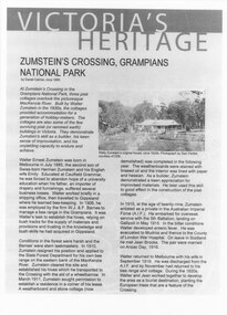
Document - Article (magazine/newspaper)
Article (3pages) written by David Catrice for Parks Victoria. More history on Walter Zumstein and the Zumstein area can be found on p137, 153 -156, 83, 107, 136 of "Victoria's Wonderland: a Grampians History"3page Article describes Walter Zumstein and the area known as 'Zumstein's'. Entitled Zumstein's Crossing, Grampians National Park from "Victoria's Heritage", Parks Victoria c1995media, magazine articles -
 Whitehorse Historical Society Inc.
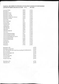
Document - Centenary History of State Education in Victoria, Victorian Education Department, Centenary History, 1973
Selected pages of schools in the Nunawading area from "Vision and Realisation". A Centenary History of State Education in Victoria. N.B. State schools are now called Primary SchoolsA list and description of schools in Whitehorse from "Vision and Realisation"A4 photocopy of 58 selected pages from "Vision and Realisation": a "Centenary History of State Education in Victoria" by the Victorian Education Department. Volume 3 dealing with schools in the Nunawading areavictorian education department, burwood east state school no.454, nunawading (sagoe common school) (box hill) no.463, nunawading (boroondara) catholic school no.464, nunawading state school (canterbury road) no.469, vermont state school. no 1022, burwood east state school no 461, nunawading north state school no 2242, mitcham state school no.2904, blackburn state school no.2923, blackburn open air school no.3850, blackburn south state school no. 4035, nunawading state school no.4190, forest hill state school no.4251, nunawading migrant centre no.4706, blackburn north state school no.4715, tally ho training farm no.3588, winlaton girls youth training centre no.4794, blackburn east state school no.4800, nunawading south state school no.4808, antonio park state school no.4844, blackburn lake state school no.4860, laburnun state school no.4863, mitcham special school no.4871, blackburn high school, blackburn south high school, mitcham high school, nunawading high school, vermont high school, mitcham technical school, primary schools, secondary schools, blackburn technical school -
 Kew Historical Society Inc
Map, Department of Lands & Survey, Map of Melbourne & Suburbs, 1899
The Melbourne & Metropolitan Board of Works was established in 1891 to oversee the introduction of a sewerage and water reticulation system in Melbourne and its suburbs. This complementary map was produced by the Department of Crown Lands & Survey [Victoria] in the same decade showing the distribution of water in Melbourne for use by fire brigades. While by 1910, there were 123,227 connections to Melbourne's water supply system, it is unclear in this 1899 map whether water was supplied to all built structures in the defined areas or only to fire hydrants and stand pipes, as we know that the first connection of a building to the sewerage system in Kew only occurred in 1904.Map accompanying report on fire protection of Melbourne showing those areas supplied with water in colour.water reticulation -- melbourne (vic.), department of lands & survey -- historic maps, fire brigades -- melbourne (vic.), cartography -
![Map, [Coornmill land area available for leasing for grazing, Parish of Coornmill]. Circa 1904](/media/collectors/5e461d8021ea67224c82f2a1/items/677cde147f2053f3e5d277c3/item-media/677cdeea7f2053f3e5d27bb4/item-fit-380x285.jpg) Bacchus Marsh & District Historical Society
Bacchus Marsh & District Historical SocietyMap, [Coornmill land area available for leasing for grazing, Parish of Coornmill]. Circa 1904
This map shows an area of land north of Bacchus Marsh in the Larderderg State Park area known as the Parish of Coornmill.The map indicates an area of land which was to be made available by public tender for grazing leaseholders. The plan to do this was discussed in the Bacchus Marsh Express newspaper on the 16 July, 1904, page 2, column 7. The area reserved for grazing leases is identified by red lines on the map. The Express described the area available for grazing was 12,000 acres.A single page paper map showing an area of land in the Parish of Corrnmill to be made available for grazing leases. A photo lithographed Lands Department Map. No scale indicated. The map is pasted into a bound volume containing 76 maps or plans in total. High resolution digital image stored on BMDHS computer network. coornmill parish maps, lerderderg state park maps, agriculture bacchus marsh area -
 Kew Historical Society Inc
Photograph, Chipperfield's Boat House & Floating Pontoon, 1934
Living with natural processes was frequently a challenge to early European settlers and later residents of what was in the 1850s administered by the Borondara Road Board. This was compounded by the area being bounded on three sides by rivers (Yarra River, Koonung Creek and Gardiner's Creek). In 1849, the historian James Bonwick recorded that "our district [Kew] suffered considerably. Mr Wade speaks of 80 acres, out of 100 acres of his cultivated paddock, covered by water." Newspapers continued to describe major flooding in Kew in 1863, 1869, 1878, 1880, 1889, 1891, 1916 and 1934. While the construction of the Upper Yarra dam in 1957 reduced the levels of flowing downstream, local and riverine floods continue. A number of boat houses operated on both sides of the River Yarra at Kew. Chipperfield's Boat House was located on the Yarra near the corner of Kilby and Willsmere Roads.The Kew Historical Society's pictures and map collections testify to the impact of flooding in the district. They have historical importance in documenting the extent of flooding in the district and its affects on homes, services and recreation. Numerous photographs record flooding throughout the Twentieth Century.Floating pontoon at Chipperfield's Boat House where the canoes were stored, taken in 1934, presumably before the 1934 Flood. This area of the Yarra was shallow with a number of mid river sandbanks and a popular swimming area for locals.yarra river, chipperfield's boathouse, pontoon -
Whitehorse Historical Society Inc.
Article, Let's get facts says first mayor, 1977
Photocopy of 'Letter to the Editor' by Norman Armstrong urging support for the Box Hill and District Hospital.Photocopy of 'Letter to the Editor' by Norman Armstrong urging support for the Box Hill and District Hospital. As first mayor of Nunawading he stresses the hospital was built to serve the whole area and has continued to do so.Photocopy of 'Letter to the Editor' by Norman Armstrong urging support for the Box Hill and District Hospital. armstrong, norman, city of nunawading, box hill and district hospital -
Whitehorse Historical Society Inc.
Pamphlet, Collina Glen, 2004 - 2007
Collina Glen Bushland Vegetation Action Statement by Parks Wide.Collina Glen Bushland Vegetation Action Statement by Parks Wide stating management recommendations, a sketch of the area, and plant list. Also copies of letters and emails to and from Valda Arrowsmith and Whitehorse Council.Collina Glen Bushland Vegetation Action Statement by Parks Wide. collina glen, mitcham, city of whitehorse, arrowsmith, valda, parks wide, parks and reserves -
 Stawell Historical Society Inc
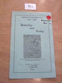
Book, N.A. McLennan, Yesterday and Today - Ord River Station WA 1895 - 1896 by N A McLennan, 1965
John McLennan's Period as Manager of the Ord River Station. W.A. adjoining Negri Station N.T., was 1895-6. The whole area consisted of 3,365,000 areas under a number of leasesand the then owner was Mr W.H. Osmand, who lived at "The Sycamores" four miles east of Stawell in Victoria. The Distance to Ord W.A. is 4,000 Miles.LIght green card cover with border, inside print and picture of a map Ord River Station W.A. 1895-1896 Yesterday and Today Map of North-East of W.A. Kimberly Ord River area Negri Station N.T. Complied and written by N.A. McLennan December 1965 1965 Victoriastawell, mclennan family -
 Ringwood and District Historical Society
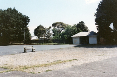
Photograph, Ringwood State School-Various photographs, Circa 1990's
Coloured photographs11 photographs -Ringwood State School - Sports Area -
Federation University Historical Collection
Book, Australian Government Publishing Service, Higher Education: A Policy Statement, 1988, 1988
Robert H.T. Smith was Chancellor of University of Ballarat (later Federation University Australia)..1) White soft covered book Areas of text have been highlighted throughout the text. robert h.t. smith, university, higher education, j.s. dawkins -
Federation University Historical Collection
Book, Australian Government Publishing Service, Higher Education: A policy Discussion Paper, 1987, 1987
Robert H.T. Smith was Chancellor of University of Ballarat (later Federation University Australia)..1) Green soft covered book Areas of text have been highlighted throughout the text. robert h.t. smith, university, higher education, j.s. dawkins, educaiton and training -
Stawell Historical Society Inc
Map, Stawell Gold Mine, Provisional Plan Wonga Area, c1980
c1980 Preliminary Provisional Reconnaissance Plan Showing Workings Above and Below water LevelWonga Area 1:1000 Base Geological Sheet mining, gold, map -
 8th/13th Victorian Mounted Rifles Regimental Collection
Photograph
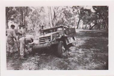
The 8th/13th Victorian Mounted Rifles was raised as a regiment of the Royal Australian Armoured Corps on 1 May 1948 with Headquarters in Melbourne and squadrons in Sale, Benalla/Wangaratta and Albury. In 1955 Regimental Headquarters moved to Wangaratta and a second squadron was located at Albury. The Sale squadron transferred to 4th/19th Prince of Wales’s Light Horse. In 1977 8/13 VMR Regiment was reduced to an independent squadron A Squadron 8th/13th Victorian Mounted Rifles and in 1991 was linked with 4th/19th Prince of Wales’s Light Horse forming the VMR Squadron of that regiment.Collection of photographs showing early evolution of an armoured regiment of the Citizen Forces as it progressed from WWII equipment and uniforms to post-war equipment and uniforms. Silver regimental hat badges are worn in place of Rising Sun badge.Black and White photograph of White Scout Car heavily bogged on exercise in Chiltern Forest. Four so;diers digging the vehicle out." 1956 White Scout Car bogged in Chiltern area. " -
 8th/13th Victorian Mounted Rifles Regimental Collection
Photograph
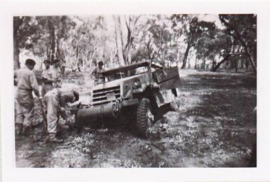
Collection of photographs showing early evolution of an armoured regiment of the Citizen Forces as it progressed from WWII equipment and uniforms to post-war equipment and uniforms. Silver regimental hat badges are worn in place of Rising Sun badge.Unique collection of photographs showing the first years of an armoured regiment of the post-Second World War era Citizen Military Forces showing equipment, uniforms, training and social activity and some personalities.Black and white photograph of White Scout Car bogged in bushland: soldiers digging it out." 1956 White Scout Car bogged in Chiltern area. " -
 Ballarat Tramway Museum
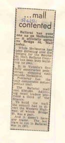
Newspaper, The Courier Ballarat, "...mall contented", 5/06/1981 12:00:00 AM
Newspaper clipping from the Courier dated 5/6/1981, mounted on a sheet of an A4 sheet of scrap paper from a Vic Government department titled "...mall contented". Article notes the official opening of the Bridge St Mall on that date, Footscray Mall being the only comparable while Melbourne is "dithering" over Burke St. Mall. Noted that the last tram ran through Bridge St in 1971."5/6/81" in blue ink on the headline area.ballarat, bridge st, bridge mall -
 Ballarat Tramway Museum
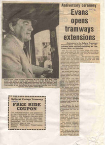
Newspaper, The Courier Ballarat, "Evans opens tramways extensions", 21/09/1981 12:00:00 AM
Has a strong association with the opening of the depot extensions by the local member of state parliament and the BTPS work in celebrating the 10th year of the closure of the Ballarat Tramway system.Newspaper clipping from the Courier dated 21/9/1981, mounted on a sheet of an A4 sheet of scrap paper from a the Forestry department titled "Evans opens tramways extensions". Article notes the official opening of the BTPS extensions to the tramway depot my Mr. Tom Evans MLA on the Saturday 19/9. Quotes Mr Evans, Ballarat Mayor Cr. A.E. Hancock and Richard Gilbert General Manger of the BTPS. Also includes a Free Ride Coupon. Features photo of Tom Evans wearing a SEC cap at the controls of a single trucker."21/9/81" in blue ink on the headline area.btps, depot, depot extensions, celebrations, opening -
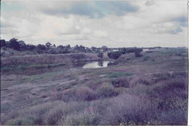 Darebin Parklands Association
Wetlands near BBQ area. 1982, Darebin Parklands Association, 1982
Colour photograph This item and all other Darebin Parklands Association archival material is now held by State Library Victoria (Accession No: YMS 13746). Please contact State Library Victoria if access is required.Annotated on back. [Wetlands near BBQ area 1982] -
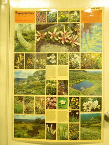 Kiewa Valley Historical Society
Map / Chart, Vegetation Map & Guide to Alpine Flora: Rocky Valley, 1982
This poster is of Rocky Valley is on the Victorian High Plains where the State Electricity Commission of Victoria worked on the Kiewa Hydro Electric Scheme and also where cattlemen brought their cattle up during summer at various times. Its significance is due to it shows the flora of the area after the Kiewa Hydro Electric Scheme Rocky Valley damn has been build and therefore is a valuable for comparison to see what plants are there now after this information on this poster was complied. Historic: Comparison of the flora at Rocky Valley with other areas on the Victorian High Plains and with Rocky Valley before and after the Kiewa Hydro Scheme and / or grazing there. Is therefore research significance and interpretive capacity due to this compatibility value.Laminated double sided vegetation map and guide to the Alpine flora of the Rocky Valley area, with photographs of plants and vegetation.rocky valley. alpine. flora. vegetation. plants. s.e.c.v.. cattlemen. victorian high plains. -
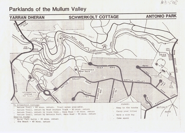 Whitehorse Historical Society Inc.
Pamphlet, Parklands of the Mullum Valley, 1998
recreation areas of the Mullum ValleyLeaflet of introduction to the parks and recreation areas of the Mullum Valley including a map of the area. recreation areas of the Mullum Valleyparks and reserves, yarran dheran, schwerkolt cottage, antonio park, mitcham, mullum mullum creek -
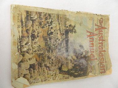 Kiewa Valley Historical Society
Book - Historical, The Australasian Pictorial Annual 1934, Vol. 3, October 1. 1934
This book was printed in 1934, giving an insight into journalism, advertising, fashion, opinions, issues, photography of the time. It also shows areas and buildings within Australia in 1934 allowing a comparison before and after this date. Historic: Comparison of areas etc. in Australia to areas etc. within the Kiewa Valley.Large book with stiff paper coloured cover showing a mob of sheep. Tattered discoloured pages with coloured and black and white photos and print of different areas within Australia.Inserted inside the book - a copy of 'The Sydney Cove Chronicle' dated 30th June, 1790 and printed December 1969. newspaper. pictorial annual 1934.