Showing 287 items
matching bendigo area map
-
 Bendigo Historical Society Inc.
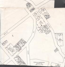
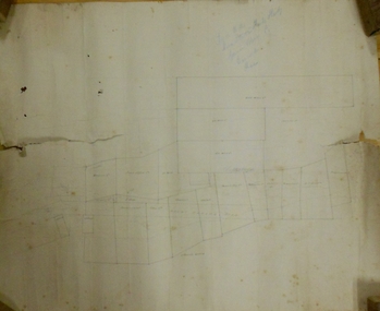
Map - VICTORIA HILL - MAP - HAPPY VALLEY RD - DARE ST
Small map showing some blocks of land in the Happy Valley Road, Dare Street and Wells Streets area. Three of the blocks are in the name of Rae. Notes by Albert Richardson.map, bendigo, victoria hill, victoria hill, victoria hill - map - happy valley road - dare street, w rae, j rae -
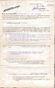
 Bendigo Historical Society Inc.
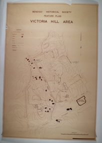
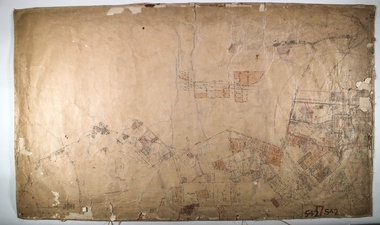
Map - VICTORIA HILL AREA, May 1971
Map: Bendigo Historical Society feature plan. There are 3 of these plans, one is without feature names and one has several places highlighted in pencil. Compiled by AHQ Survey Regiment, CMF Increment ( number 181 in Map Cupboard 1)map, bendigo, mining plan, victoria hill, bendigo historical society, conrad heinze butchers -
 Bendigo Historical Society Inc.
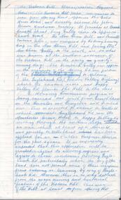
Document - VICTORIA HILL - CLASSIFICATION REQUEST
Handwritten, 3 page carbon copy of a classification request for victoria Hill. Notes give locality, housing program in the area, immediate surrounds of the area, prominent citizens, buildings, mines, geographical formations and gold production. Notes prepared by Albert Richardson.mining, parish map, victoria hill, classification request for victoria hill, gold mines hotel, john brown knitwear factory, lansell's fortuna villa, army survey corp, housing commission, hercules, energetic, ironbark, manchester arms hotel, bendigo goldfield, old miners homes, george lansell, sir george lansell, bendigo advertiser, theodore ballerstedt junior, mr c t c johann ballerstedt, mr wm rae, david sterry, adventure, wittscheibe's 'jewellers shop', luffsman & sterry's rich claim, ballerstedt open cut and mine, lansells 180, victoria quartz, rotary club of bendigo south, bendigo cemetry -
 City of Greater Bendigo - Civic Collection
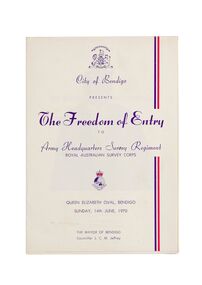
Ceremonial object - Invitation, City of Bendigo, The Freedom of Entry, 1970
On the 27th March, 1942 'Fortuna House' was occupied by LHQ Cartographic Company, Australian Survey Corps. Fortuna was the site of the base map plant and during this time approximately sixteen million maps of Australian Territories in the South West Pacific area were produced for use by the Allied Services. Fortuna was purchased in 1951 by the Commonwealth Government and until 1970 the Survey Corps and Regiment became part of community life in the district. This event to grant the Regiment Freedom of Entry took place at the Queen Elizabeth Oval on Sunday 14th June, 1970.Booklet outlining the celebrations commemorating the Army Survey Regiment's time in Bendigo. Includes a short history of the Regiment's association with the City which spanned from 1942 - 1970 as well as the day proceedings attended by the Mayor and Councillors.fortuna house, george lansell, royal aust survey corps, queen elizabeth oval, mayor jeffrey -
 Bendigo Historical Society Inc.
Map - LONG GULLY HISTORY GROUP COLLECTION: LONG GULLY
Copy of a map of Long Gully area with some street names, size of allotments, number, measurements, date and names.bendigo, history, long gully history group, the long gully history group - long gully, housing commission, housing act 1958, gazette -
 Bendigo Historical Society Inc.
Map - LOCAL AREA PLANS, See above
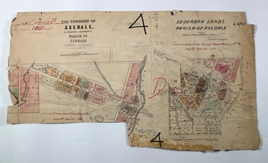
Map: Compilation of maps: Town lots Bridgewater dated April 29 1871. Village of Colbinnabbin, dated 5 December 1866, Township of Axedale 1858 (Larritt). Suburban lands Axedale dated April 12 1871map, bendigo, parish plan, bridgewater, colbinnabbin, axedale, suburban lands -
 Bendigo Historical Society Inc.
Map - PETER ELLIS COLLECTION: MAP OF WHIPSTICK
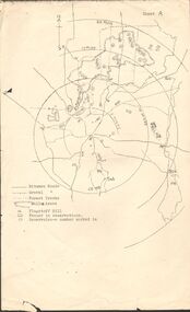
Two maps of the Whipstick - Sheet A and Sheet B. Sheet A shows the Whipstick in relation to Bendigo and some surrounding places. Bitumen roads, gravel, forest tracks, Mallee Areas, Flagstaff Hill, fenced in reservations and reservoirs are marked. Also, a circle and part circles of 5-, 10-, 15- and 20-mile radius is marked. North & South are marked. Sheet B is an enlarged area of the Whipstick Scrub area. North and South is marked. There are a number of letters written over both maps.map, bendigo, peter ellis collection, the whipstick, flagstaff hill -
 Bendigo Historical Society Inc.
Document - ALBERT RICHARDSON COLLECTION: FORTUNA HUSTLERS MINE
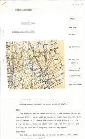
Two-page document with location map. The Fortuna Hustlers Gold mine was located close to the railway goods shed (Discovery Centre location) in an area occupied by Buckell and Jeffrey's office and yards. (now carpark of Marketplace shopping centre). It commenced operation in August 1888 and closed in December 1913.The depth of the shaft was 2,240ft. Features of the plant described are: the winding engine, the air compressor, boilers, baling tanks, poppet legs, engine house. The winding engine later worked at the Tambour Major at Specimen Hill; Birds Reef at Kangaroo Flat, Hercules No. 1 on top of Danger Hill and the North Virginia mine at Eaglehawk.bendigo, mining, fortuna hustlers mine -
 Bendigo Historical Society Inc.
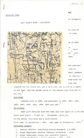
Document - ALBERT RICHARDSON COLLECTION: NEW RED, WHITE AND BLUE CONSOLIDATED MINE, GOLDEN SQUARE
Two-page document plus map showing location of the New Red, White and Blue Consolidated mine on the Sheepshead Line of Reef. Information on the mine is given in the following areas: location plant, early history, its role as a leading mine, its prominence, its closure, gold production. References are provided. Document forms part of research referred to in Albert Richardson's paper 2264.70.bendigo, mining, new red white and blue mine -
 Bendigo Historical Society Inc.
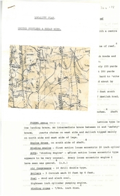
Document - ALBERT RICHARDSON COLLECTION: UNITED HUSTLERS AND REDAN MINE
Four-page typed document plus location map. The United Hustlers and Redan mine was located in the North Bendigo, Long Gully area on the Hustlers line of reef. The lease was 153 acres and included Holdsworth, Holmes, Havilah Roads and Wood Street. The Redan shaft was 1,830ft and the South or K.K. Shaft was 1,960 ft. Poppet legs steel 71 ft high. Features of the plant are described including the engine house, winding engine, air compressor, boilers, fuel, winding ropes.bendigo, mining, united hustlers and redan mine -
 Bendigo Historical Society Inc.
Document - GARDEN GULLY LINE OF REEF, LEASE BLOCKS 5360 AND 5361
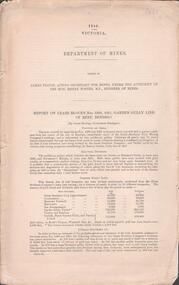
Two page document titled ' Report on lease blocks Nos. 5360 and 5361 Garden Gully line of reef, Bendigo. Produced by the Department of Mines 1899. The area described is about 'one mile and a quarter southeast from the centre of the city of Bendigo, immediately south of the Great Southern Gold Mining Company's workings and is intersected by two auriferous gullies ... Salomon's Gully and Derwenter's Gully'. The alluvial deposits, the Garden Gully line, the Great Souther Co.and old workings are discussed in the paper. A map of the Garden Gully line of reef is attached to the report, showing claimholders and mine names along that section of the reef. Mines named on the map: Great Southern Garden Gully United Ulster Londonderry Burrows Horwoods Sea Amalgamated Garden Gully United Victory and Pandora Unity Carlisle and Garden Gully and Passbye United Cornish United Koch's PioneerJames Stirling, Government Geologistbendigo, mining, garden gully line of reef mines -
 Victorian Railway History Library
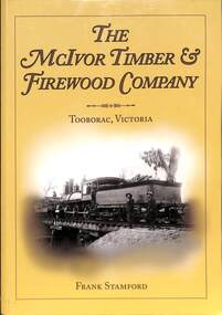
Book, Frank Stamford, The McIvor Timber and Firewood Company Tooborac, Victoria, 2014
A history of the company which operated from 1906 to 1927, supplying firewood to Bendigo. Includes details of rolling stock and the line. Includes illustrations. Toobaroc is in the Shire of Mitchell local government area.Index, bib, ill, maps, p.104.non-fictionA history of the company which operated from 1906 to 1927, supplying firewood to Bendigo. Includes details of rolling stock and the line. Includes illustrations. Toobaroc is in the Shire of Mitchell local government area.fuelwood industry -- victoria -- tooborac -- history., logging railroads -- victoria -- tooborac -- history. -
 Bendigo Historical Society Inc.
Map - MARKS COLLECTION: CLAIM MAP SANDHURST
Original hand drawn map showing lease holders along Mt. Korong Road, Sandhurst area. Names include Gold Mines Co., Hercules Co., H. Koch, Prince Alfred Co, Advance Co., J. Steane, Skeals, Abel & Co., Mounts(?) Bay co., Wellington Co., Waterloo Co., Endeavour Co., W.H. Langdon, Bridgman & Co. Written in blue pencil on top RH corner in script Syme Well, Nova Ste (indecipherable), German Aleno Co., Concord, Rae. Written on back of map in black pen 'Maps'.map, bendigo, mining leases -
 Bendigo Historical Society Inc.
Map - SANDHURST ? SHEET 5, 29/10/1879
Map: Parish plan showing area Northwards from Kangaroo Flatmap, bendigo, parish plan, parish of sandhurst, kangaroo flat -
 Bendigo Historical Society Inc.
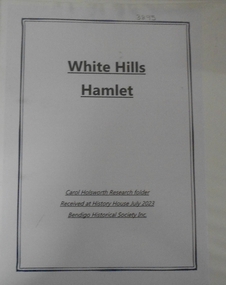
Document - RESEARCH FOLDER COLLECTION: WHITE HILLS HAMLET, 1990 - 2015
Folder of research material compiled by Carol Holsworth. Received at History House in July 2023. White Hills Hamlet Includes Newspaper articles including many photographs of properties in the White Hills area advertised for sale Historical information about White Hills Hamlet properties Family history information about former residents of the White Hills area Notes based on electoral rolls, local directories, and rates records MapsCarol Holsworthbendigo, history, white hills hamlet -
 Bendigo Historical Society Inc.
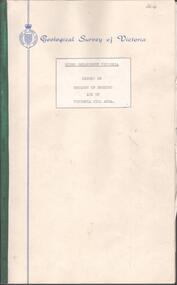
Document - BENDIGO AND VICTORIA HILL REPORT ON GEOLOGY
Report, 8 pages, on the geology of Bendigo district and Victoria Hill, produced by the Geological Survey Dept., Victorian Government. G.J. Medwell, Geologist. 19.10.1967. On front 'Geological Survey of Victoria. Mines Department Victoria. Report on Geology of Bendigo and of Victoria Hill Area' Letter attached inside front cover to J.C.Balfour, Minister of Mines to G.A. Lambert, Liberal Party, Sunshine, Victoria, sent with book for his information. Report contains: Cobaw batholith and North Harcourt Bendigo goldfield generally Trought, reefs, saddles and spurs Victoria Hill mines; Victoria Consols, Great Central Victoria, Victoria Quartz, Lansells 180, North Old Chum. Maps attached show part of New Chum line of reef and a handdrawn map of Rae's Cutting.bendigo, mining, victoria hill, bendigo goldfield -
 Bendigo Historical Society Inc.
Document - INDENTURE, GOLD MINING LEASE 11081 CROWN AND HERBERT JACKSON LEED OF BENDIGO, MCCOLL, RANKIN AND STANISTREET COLLECTION, 21st September, 1940
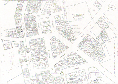
Six page document plus map, dated 21st September 1940, between the Crown and Herbert Jackson Leed, for the land shown on the accompanying map 'indicated by yellow colour' Depths indicated on lease document. On map: Mining District of Bendigo, County of Bendigo, Parish of Sandhurst. No. 11081. Net Area 24 acres, 3 roods, 3 perches. Signed by Herbert Leed and ?Walsh, Warden Clerk, Bendigo. Map shows lease holding 11081 coloured yellow. Other leases: no's. 9882 11081, 11034, 11080. Streets: Fletcher Street, and Belle Vue Road. Gullies: Derwenters Mistake Bully and Pig Face Gully on lease 11081. Quarry Hill Recreation Reserve marked and some residential allotments. Water race indicated on map. On back of document: ; Deborah United Gold Mining Company No Liability of Charing Cross Bendigo is now the proprietor of the within described estate by transfer registered on 21st November 1940 and numbered 1795202.bendigo, mining, deborah united gold mine, herbert jackson leed, deborah united gold mining. major general sir winston joseph dugan