Showing 655 items
matching bourke road
-
 Kew Historical Society Inc
Plan - Subdivision Plan, J R Mathers & McMillan, Myrtle Hill Estate, East Kew, circa 1949, c.1949
The Kew Historical Society's map collection includes a substantial number of real estate subdivision plans, mainly of Kew but also of surrounding suburbs in Melbourne. Most of the subdivision plans date from the 1920s and 1930s when the districts old homes and local farmland were being split up to accommodate residential growth in the postwar period. These early plans were assembled by a local firm, Jas R Mather & McMillan, which had an office in Cotham Road. Many of the plans, and sometimes photos, were annotated by the agents.Subdivision plans are historically important documents used as evidence for the growth of suburbs in Australia. They frequently provide information about when the land was sold as well as evidence relating to surveyors and real estate and financial agents. The numerous subdivision plans in the Kew Historical Society's collection represent working documents, ranging from the initial sketches made in planning a subdivision to printed plans on which auctioneers or agents listed the prices for which individual lots were sold. In a number of cases, the reverse of a subdivision plan in the collection includes a photograph of a house that was also for sale by the agent. These photographs provide significant heritage information relating house design and decoration, fencing and household gardens.The photograph may also be aesthetically significant depending on the importance of the photographic atelier.Myrtle Hill, at 14 Vista Avenue, Kew, is of local historical and architectural significance as a good example of a large and imposing single-storey Italianate house of the early 1870s surviving in Kew. Originally sited on a large allotment overlooking Normanby Road, the setting of the house has been dramatically altered through extensive subdivision and development. The subdivision plan of the ‘Myrtle Hill Estate’ indicates that in one such subdivision, 11 allotments were created fronting Bowyer Avenue, Myrtle Avenue, and Normanby Road. The outline and building profile of Myrtle Hill is shown on the west side of Bowyer Avenue.The full (typed) title of this subdivision plan is :"Plan of SUBDIVISION of part of CROWN PORTION 83. / at KEW / PARISH OF BOROONDARA. / COUNTY OF BOURKE". / "MYRTLE HILL ESTATE / EAST KEW" In addition to the Title and subtitle, the plan also lists the advantages of the subdivision. -
 Kew Historical Society Inc
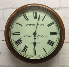
Functional object, Jas Murray & Co, Wall Clock & Key, 1860s
The clock was purchased from Jas Murray & Co. of 107 Bourke Street East, Melbourne by Francis Barnard. James Murray & Co were well known clock and watchmakers operating from premises in London with branches in Calcutta and Melbourne. They were watchmakers and jewellers in Melbourne from 1860 to 1888. Francis Barnard established Barnard’s Pharmacy on the corner of Bulleen Road (later renamed High Street) and Cotham Road in 1857. In the early 1860s, after purchasing the clock, he placed it in his pharmacy where it could be seen by passers by. When he relocated across the road to 49 Bulleen Road (now 167 High St.) in 1880 he took the clock to the new premises. He maintained the accuracy of the clock so that local residents consulted it for the correct time, even after the Post Office building with its clock tower was opened in 1888. When Francis Barnard retired, his son took over the pharmacy. In 1925, the Barnard Pharmacy was sold to David Paton. The Paton’s were at first puzzled why people constantly peered in the door until they realised that the timepiece was the drawcard. When David Paton died in 1941, his widow sold the pharmacy but took the clock with her to her new florist shop at 145 High Street. When Mrs Paton retired in 1953, she took the clock to her home in Boronia. In 1973 her daughter donated the clock to the Kew Historical Society.Significant locally to Kew as an example of a timepiece that was used by the local community during the 19th century to tell the time.Barnard’s clock is a typical wall clock of the nineteenth century, variants of which could be seen in shops, offices, public buildings and stations. It has a mahogany case with a moulded wooden bezel encasing a hinged brass bezel housing the glass face which protects the dial and hands when working. The clock face has an off-white hand painted tin dial with black painted Roman numerals. The hands are black painted metal; the hour hand has a wide spade shaped point whilst the minute hand is much thinner. ‘Jas Murray & Co’ is painted above the centre, with ‘107 Bourke Street East’ and ‘Melbourne’ below, with the key hole in between. The clock movement is a fuse chain attached to a brass mainspring barrel which powers the pendulum for eight days. This is housed within a rectangular wooden casing with a convex curved base housing a hinged door giving access to the pendulum which is attached to the back of the clock by four wooden pegs.Jas Murray & Co / 107 Bourke St East / Melbournefrancis barnard, f g a barnard, high street - kew (vic), pharmacies - kew (vic), clocks, paton's pharmacy --- kew (vic.), bulleen road -- kew (vic.) -
 Kew Historical Society Inc
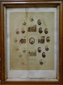
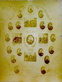
Award, Kew Fire Brigade / Best Average Time, 16 points / U.F.B.D. Sandhurst, 1886
1879 - The Argus, Friday 11 July 1879, page 4. The Kew Borough Council having decided to initiate a fire brigade, invited volunteers to send in their names. About 40 complied with the invitation and met at the Town-hall to choose 12 of their number to form the brigade. The 12 elected then chose their officers as follows :— Councillor Gray, captain ; Mr. Thomas Greenhill, foreman ; and Mr. H. Loxton, secretary. The brigade decided to apply to the council for uniforms and a bell; and after adopting rules for their guidance the meeting separated. The brigade now possesses a reel and 500ft. of hose, and a shed is being erected in Little Walpole-street for a station. The council have applied for six additional fireplugs in the Main-road, so that the brigade may now be considered fairly established. 1886 - Globe (Sydney), Tuesday 16 March 1886, page 8 The Kew Fire Brigade, which obtained the pride of place at the recent fire brigades' demonstration, at Sandhurst, was met on their return at Spencer-street Railway Station by the Mayor and Councillors of that suburb, and were subsequently entertained at the Greyhound Hotel. 1886 - South Bourke and Mornington Journal, Wednesday 17 March 1886, page 2 It may be, deemed remarkable, but nevertheless a fact, 'that the Kew Fire Brigade, comparatively a new one, has gained premier place at the recent contest of brigades held at Ballarat, winning two first prizes and two second. On returning they were met at the station and escorted to Kew, preceded by the Borough banner. Certificate awarded to the Kew Volunteer Fire Brigade as an award for winning 'the best average time' in competition at Sandhurst. Surrounding the team's photo are a series of individual oval named portraits of the team. This framed version of the certificate, (there are two in the collection) is less faded than the framed version.The photograph without the mount (2016.0097a) has been digitally enhanced. Inscription: "Kew Fire Brigade U.F.B.D. Sandhurst. Kew 1886: Best Average Time, 16 points"kew volunteer fire brigade -
 Kew Historical Society Inc
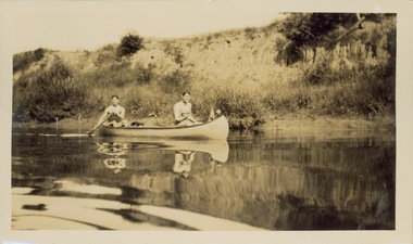
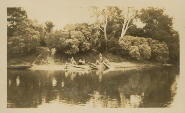
Photograph - Victorian Canoe Club, Yarra near Burke Road, 1920-30
... Burke Road -- Kew (Vic.) "Near Bourke Rd" One of 24 labelled ...Canoeing on the River Yarra at Melbourne was an important and widespread recreational pursuit for Melbournians, especially in the first half of the twentieth century. The Victorian Canoe Club was formed in 1912 at a meeting in Melbourne and its first committee elected in the same year. Records indicate that the Club continued into at least the 1950s .The album has historic and social significance as a record of recreational activities (as well as canoe making) in the early years of the twentieth century. It has local significance as the site of the headquarters of the Club was in Studley park. A number of photographs in the album provide vistas of Kew on the Yarra that are otherwise unavailable.One of 24 labelled photos in part album, originating from the Victorian Canoe Club, which had its headquarters in Studley Park, Kew. The album includes a photographic record of canoe construction and also locations in Studley Park and Kew where the canoes were used. The subject of this photograph is identified as 'Near Burke Road' with two young men in a canoe on a still section of the Yarra. "Near Bourke Rd"victorian canoe club, river yarra, studley park, canoe clubs, canoeing, recreation -- canoeing, burke road -- kew (vic.) -
 Kew Historical Society Inc
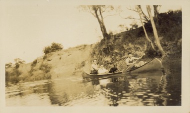
Photograph - Victorian Canoe Club, Yarra near Burke Road, 1920-30
... Burke Road -- Kew (Vic.) "Near Bourke Rd" One of 24 labelled ...Canoeing on the River Yarra at Melbourne was an important and widespread recreational pursuit for Melbournians, especially in the first half of the twentieth century. The Victorian Canoe Club was formed in 1912 at a meeting in Melbourne and its first committee elected in the same year. Records indicate that the Club continued into at least the 1950s .The album has historic and social significance as a record of recreational activities (as well as canoe making) in the early years of the twentieth century. It has local significance as the site of the headquarters of the Club was in Studley park. A number of photographs in the album provide vistas of Kew on the Yarra that are otherwise unavailable.One of 24 labelled photos in part album, originating from the Victorian Canoe Club, which had its headquarters in Studley Park, Kew. The album includes a photographic record of canoe construction and also locations in Studley Park and Kew where the canoes were used. The subject of this photograph is identified as 'Near Burke Road' with three men and a dog in a canoe on a still section of the Yarra. "Near Bourke Rd"victorian canoe club, river yarra, studley park, canoe clubs, canoeing, recreation -- canoeing, burke road -- kew (vic.) -
 Kew Historical Society Inc
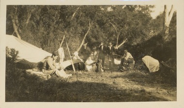
Photograph - Victorian Canoe Club, Camp site near Burke Road, 1920-30
Canoeing on the River Yarra at Melbourne was an important and widespread recreational pursuit for Melbournians, especially in the first half of the twentieth century. The Victorian Canoe Club was formed in 1912 at a meeting in Melbourne and its first committee elected in the same year. Records indicate that the Club continued into at least the 1950s .The album has historic and social significance as a record of recreational activities (as well as canoe making) in the early years of the twentieth century. It has local significance as the site of the headquarters of the Club was in Studley Park. A number of photographs in the album provide vistas of Kew on the Yarra that are otherwise unavailable.One of 24 labelled photos in part album, originating from the Victorian Canoe Club, which had its headquarters in Studley Park, Kew. The album includes a photographic record of canoe construction and also locations in Studley Park and Kew where the canoes were used. The subject of this photograph is identified as 'Camp site near Burke Road' with four canoes on the river bank with members beside them. "Camp site near Bourke Rd"victorian canoe club, river yarra, canoe clubs, canoeing, recreation -- canoeing, burke road -- kew (vic.), kew -
 Kew Historical Society Inc
Photograph - Victorian Canoe Club, Camp site near Burke Road, 1920-30
Canoeing on the River Yarra at Melbourne was an important and widespread recreational pursuit for Melbournians, especially in the first half of the twentieth century. The Victorian Canoe Club was formed in 1912 at a meeting in Melbourne and its first committee elected in the same year. Records indicate that the Club continued into at least the 1950s .The album has historic and social significance as a record of recreational activities (as well as canoe making) in the early years of the twentieth century. It has local significance as the site of the headquarters of the Club was in Studley Park. A number of photographs in the album provide vistas of Kew on the Yarra that are otherwise unavailable.One of 24 labelled photos in part album, originating from the Victorian Canoe Club, which had its headquarters in Studley Park, Kew. The album includes a photographic record of canoe construction and also locations in Studley Park and Kew where the canoes were used. The subject of this photograph is identified as 'Camp site near Burke Road' with members around a fire at a campsite."Camp site near Bourke Rd"victorian canoe club, river yarra, canoe clubs, canoeing, recreation -- canoeing, burke road -- kew (vic.), kew -
 Kew Historical Society Inc
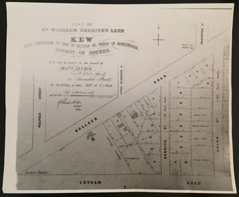
Plan - Framed Subdivision Plan (copy), F Price, Plan of Mr William Derrick's Land, Kew being Subdivision of Part of Section 86, Parish of Boroondara, County of Bourke, 1872, 1872
William Derrick was an early landowner in Kew, and with James Venn Morgan and James Dannock the purchaser of the parcel of land bounded by Cotham Road, High Street and Mary Street. Derrick Street in Kew is named after him.Map mounted under perspex. ‘Plan of Mr Willia Derrick's Land, Kew being Subdivision of Part of Section 86, Parish of Boroondara, County of Bourke’. This is a copy of the plan held in the State Library of Victoria.kew subdivision plan, john derrick, subdivision plans -- kew (vic.) -
 Kew Historical Society Inc
Award, Kew Fire Brigade: Best Average Time, 16 points, U.F.B.D. Sandhurst, 1886
1879 - The Argus, Friday 11 July 1879, page 4. The Kew Borough Council having decided to initiate a fire brigade, invited volunteers to send in their names. About 40 complied with the invitation and met at the Town-hall to choose 12 of their number to form the brigade. The 12 elected then chose their officers as follows :— Councillor Gray, captain ; Mr. Thomas Greenhill, foreman ; and Mr. H. Loxton, secretary. The brigade decided to apply to the council for uniforms and a bell; and after adopting rules for their guidance the meeting separated. The brigade now possesses a reel and 500ft. of hose, and a shed is being erected in Little Walpole-street for a station. The council have applied for six additional fireplugs in the Main-road, so that the brigade may now be considered fairly established. 1886 - Globe (Sydney), Tuesday 16 March 1886, page 8 The Kew Fire Brigade, which obtained the pride of place at the recent fire brigades' demonstration, at Sandhurst, was met on their return at Spencer-street Railway Station by the Mayor and Councillors of that suburb, and were subsequently entertained at the Greyhound Hotel. 1886 - South Bourke and Mornington Journal, Wednesday 17 March 1886, page 2 It may be, deemed remarkable, but nevertheless a fact, 'that the Kew Fire Brigade, comparatively a new one, has gained premier place at the recent contest of brigades held at Ballarat, winning two first prizes and two second. On returning they were met at the station and escorted to Kew, preceded by the Borough banner. Certificate awarded to the Kew Volunteer Fire Brigade as an award for winning 'the best average time' in competition at Sandhurst. Surrounding the team's photo are a series of individual oval named portraits of the team. This version of the certificate, (there is two in the collection) is unframed and has a badly torn mount. It is also more faded than the framed version.The photograph without the mount (2016.0097a) has been digitally enhanced. Inscription: "Kew Fire Brigade U.F.B.D. Sandhurst. Kew 1886: Best Average Time, 16 points"kew volunteer fire brigade -
 Kew Historical Society Inc
Print - Subdivision Plan, F Price, Plan of Mr William Derrick's Land, Kew being Subdivision of Part of Section 86, Parish of Boroondara, County of Bourke, 1872, 1872 [Original]
This work forms part of the collection assembled by the historian Dorothy Rogers, that was donated to the Kew Historical Society by her son John Rogers in 2015. The manuscripts, photographs, maps, and documents were sourced by her from both family and local collections or produced as references for her print publications. Many were directly used by Rogers in writing ‘Lovely Old Homes of Kew’ (1961) and 'A History of Kew' (1973), or the numerous articles on local history that she produced for suburban newspapers. Most of the photographs in the collection include detailed annotations in her hand.The Rogers Collection provides a comprehensive insight into the working habits of a historian in the 1960s and 1970s. Together it forms the largest privately-donated collection within the archives of the Kew Historical Society.A photographic reproduction of a plan in the Vale Collection of the State Library of Victoria showing William Derricks land in the area bordered by Bulleen Road (High Street); Cotham Road and Union Street. The plan dates from 1872.william derrick, subdivision plans -- kew (vic.) -
 Kew Historical Society Inc
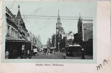
Postcard, Bourke Street, Melbourne, 1920-1920
The Kew Historical Society's postcard collection includes views of Kew, Melbourne and Greater Melbourne as well as those including overseas scenes sent or received from Europe or the Middle East. They date from the 1890s to the 2000s. These postcards may or may not include the name of the publisher or printer. A number of the cards were published as parts of popular series. A way of dating early postcards is to identify whether the reverse was divided by a central line which became the norm after 1902 in the United Kingdom. However, other postcards produced after this date do not always conform to this print layout.Monochrome postcard of Bourke Street, Melbourne, looking west from Swanston Street. The costumes of the women in the photograph would indicate the use of an earlier photograph dating from the 1885-1895.Mrs L. Clark, Ecclesbourne, Harp Road, East Kew / Wishing you many happy returns of the Day, M. Boylebourke street - melbourne, postcards -- melbourne (vic), photographic postcards -
 Kew Historical Society Inc
Plan - Subdivision Plan, Plan of Subdivision of Part of Crown Portion 84 / Parish of Boroondara / County of Bourke / Lodged Plan No. 2217, Twentieth Century
Pru Sanderson, in her groundbreaking ‘City of Kew Urban Conservation Study : Volume 2 - Development History’ (1988), summarised the periods of urban development and subdivisions of land in Kew. The periods that she identified included 1845-1880, 1880-1893, 1893-1921, 1921-1933, 1933-1943, and Post-War Development. These periods were selected as they represented periods of rapid growth or decline in urban development. An obvious starting point for Sanderson’s groupings involved population growth and the associated economic cycles. These cycles also highlighted urban expansion onto land that was predominantly rural, although in other cases it represented the decline and breakup of large estates. A number of the plans in the Kew Historical Society’s collection can also be found in other collections, such as those of the State Library of Victoria and the Boroondara Library Service. A number are however unique to the collection.The Kew Historical Society collection includes almost 100 subdivision plans pertaining to suburbs of the City of Melbourne. Most of these are of Kew, Kew East or Studley Park, although a smaller number are plans of Camberwell, Deepdene, Balwyn and Hawthorn. It is believed that the majority of the plans were gifted to the Society by persons connected with the real estate firm - J. R. Mathers and McMillan, 136 Cotham Road, Kew. The Plans in the collection are rarely in pristine form, being working plans on which the agent would write notes and record lots sold and the prices of these. The subdivision plans are historically significant examples of the growth of urban Melbourne from the beginning of the 20th Century up until the 1980s. A number of the plans are double-sided and often include a photograph on the reverse. A number of the latter are by noted photographers such as J.E. Barnes.Undated Plan of Subdivision of Crown Portion 84 in what is now Kew. The area shown is bordered by Burke Road, Harp Road, Arglye Road and Normanby Road.subdivision plans -- kew (vic), harp road, burke road, normanby road, lady loch's drive, gladstone street, second avenue, first avenue -
 Kew Historical Society Inc
Album - Photographs of heritage sites in Victoria, Eva Grant, 1964-66
Eva Grant was a member of the Kew Historical Society. Three albums in the collection were created by her, this one, the third created between 1964 and 1966. They were donated to the Society by her daughter in 2010. Each of the albums includes photographs and newspaper cuttings collected on her travels to historic places in South East Australia in the 1950s and 1960s. Particular structures photographed in this album include: Barnawatha (Vic.) - The Hermitage | Beveridge (Vic.) - Stone cottage where Ned Kelly was born. | Brighton - St Andrew’s Church graveyard. | Chiltern (Vic.) - lake view [missing] | Cowes (Vic.) - ‘Broadwater’ [originally home of Henty-Wilson family], demolished 1965; Bell of the Speke wreck; Edward’s tree. | Euroa (Vic.) - Habbies Howe | Fairfield (Vic.) - Dight’s Falls; John Dight. | Fernshawe (Vic.) - Queen Mary tree. | Jolimont (Vic.) - Old railway tunnel linking the first Government House (1964); Sign identifying location of first Government House. | Kew (Vic.) - Cairn at Dight’s Falls; Canoe tree, Bowyer Avenue. | Kyneton - De Grave’s Flour Mill - “C”. | Maldon (Vic.) - Chinese oven; Macarthur’s House; Maldon’s oldest resident; Chinese graves x 2; [Beehive Chimney]. | Marysville (Vic.) - Centenary cairn | Mitcham (Vic.), Mud brick house x 2, Deep Creek Road. | Melbourne (Vic.) - St Paul’s Cathedral [renovation] (1964); Wreckers at Damman’s Corner, cnr Bourke and Collins Streets (1964); Princess Gate project x 2 (1964); Colonial Storekeeper’s building on cnr King and Bourke Streets (1966); Early observatory 1861-3; the Honey Memorial. | Mt Oberon (Vic.) - [obsolete] radio telephone dish. | Seymour (Vic.) - Habres (sic) House x 3.| Swan Hill (Vic.) - Major Mitchell’s Cairn (12/1964); Headstone of Andrew Beverage AM (12/1964). | Templestowe (Vic.) - Finn’s Hotel. | Thornton (Vic.) - Eildon Station. | Werribee (Vic.) - Chirnside Memorial [Presbyterian] Church; gaslight beside church | Location unknown, but possibly Swan Hill - Brick house; Wooden bullock dray. | Location unknown - Headstone of John Furlonge 1835.Important record of significant heritage properties in Victoria, many of which have since been demolished.30 page spirex bound drawing book including photographs and newspaper articles of historic buildings in Victoria. The front cover has a picture of a steam boat. The cover is encased in plastic. A number items in the album are annotated with written commentary by Eva Grant who compiled the album. Annotations and transcriptions by Eva Grant on most imageseva grant, photograph albums, heritage places - victoria -
 Surrey Hills Historical Society Collection
Photograph, Parer family portrait
Members of the Parer family began arriving in Australia from 1852. By the 1890s several had settled in Surrey Hills and Box Hill. Identification is as follows: Back L to R: Phillip ( ), Stephen, Joseph, Francis. Front L to R: John, Tici, Eulalia, Tia. Phillip lived at 'Monserrat' in Mont Albert Road (land later subdivided so that house was renumbered as a Weybridge Street address. Stephen was was the youngest child of Antonio and Josefa Parer. He left for Australia when he was 17 years old and landed in Melbourne in 1888 and went straight to work at Parers’ Crystal Palace for his brother Francis. Stephen preferred the outdoors and went to work on the family market garden in Box Hill. Joseph was the first Parer to arrive in Australia, in 1855. He and his brother Francis created the Parer dynasty in Australia, bringing all the family members from Spain and offering them work in their hotels. Francis Parer was born in Alella in 1836 and left for Australia when he was 17. In partnership, he commenced a business of general produce dealers in Little Bourke Street. He later entered the hospitality business buying in partnership the ‘Spanish Restaurant’ on Elisabeth Street and later, the Victoria Restaurant on Bourke Street with his brothers. In 1870 he purchased 40 acres of land at Box Hill at £15 per acre. The property became a famous market garden where he grew all kinds of vegetables and orchards. It is believed the first tomatoes in Australia were grown there. Juan or John lived in 'Gerona' in Weybridge Street. Eulalia Parer married Marcus Clota at Alella on 9 September 1867 and came to Australia in 1876. They lived in Guildford and Union Roads. Tia Marieta married and lived in Guildford Road. There are many members of the family buried in Box Hill Cemetery. Black and white formal studio portrait of 8 members of the Parer family mounted on brown board. There are 4 men standing and one man and 3 women seated.White paper label stuck to rear: "THE ORIGINAL PARER FAMILY WHO SETTLED IN AUSTRALIA - 1852. / Photograph with compliments of SANS family."phillip parer, stephen parer, box hill cemetery, joseph parer, francis parer, john parer, tici parer, eulalia parer, tia parer, "monserrat" -
 Surrey Hills Historical Society Collection
Photograph, Frank Cornell of 'Casallenroc,' 4-8 Lorne Parade
Frank and Blanche Cornell had their home built in 1904. Mr Cornell was a keen gardener, usually doing 2 hours’ work before going to work. He was a director of Buckley & Nunn, Bourke Street, having worked up from a position as shipping clerk. Frank was a great supporter of and worker for the Empire Day celebrations in the 1905-1911 period and also of the bowling club. He was also a keen photographer. Frank Cornell was first listed in Surrey Hills in 1906 at (6) Lorne Parade. In 1908 the listing gives his occupation as a clerk. He was born in 1869 in Richmond, Victoria and died 15 April 1917 in Surrey Hills from a stroke. His wife Blanche Annie Parsons Cornell (nee Bracher) was born in 1869 in Hokitika, New Zealand; she died on 21 January 1940. Children were: Gilbert Frank Cornell (b1894, Hawthorn; d1908, at Frankston beach, an accidental drowning) Ruth Amelia Cornell (b 1899, Kew; d 29 May 1977, Kew) Lorna Amy Cornell (b 1906, Surrey Hills; d unknown) Patience Blanche Cornell (b1907, Surrey Hills; d unknown). Frank and wife Blanche are buried in Box Hill Cemetery - CE-*-1058. Ruth Amelia married David Ellis, c1922 in Surrey Hills. David was a dentist who practised in Surrey Hills for many years. Patience (Pat) Blanche married Norman Henry Brewer (1893–1975) in 1931 in Surrey Hills.A black and white photograph of a man dressed in a 3 piece suit with flowers in his buttonhole, and a bow tie. He is also sporting a moustache.(mr) frank cornell, buckley and nunn, empire day celebrations, house names, lorne parade, surrey hills, (mrs) blanche amy parsons cornell, box hill cemetery, surrey hills bowling club, 'casallenroc' -
 Surrey Hills Historical Society Collection
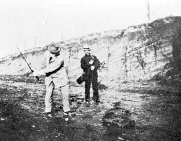
Photograph, Surrey Hills Golf Club - the cutting in (now) Whitehorse Road, 1905, 1905
Reproduced by permission of Mr John Arnold from his book: "The Riversdale Golf Club - a history, 1892-1977." Copyright to book: Riversdale Golf Club. Surrey Hills Golf Club operated from 1892-1908 then moved and became Riversdale Golf Club. The game was played across paddocks from Trafalgar Street, Mont Albert to Whitehorse Road and down Victoria Crescent to where Box Hill TAFE is now located in Elgar Road. There were problems with cows eating the tee flags! The clubhouse still exists as 30 Trafalgar Street. The men are standing on what is now Whitehorse Road in the cutting which can still be seen near the Box Hill Motel. Walter John Carre Riddell: Born c1859; died 12 March 1930; unmarried. Father came from Riddell in Scotland and took up land at Riddell's Creek, near Gisborne. W J Carre Riddell was educated at Melbourne Grammar, graduated in law from Melbourne University in 1882 and practised law until 1907. MLA for West Bourke for 17 years. Chairman of MMBW from 1907 until retirement in 1927. Versatile sportsman. REF: Obituary in Trove - The Argus, 13 March, 1930, p8.The image is significant for its association with Walter John Carre Riddell who was a significant identity in early 20th century Melbourne. His was well-known for his sporting prowess. In early life he was a keen footballer, cricketer and tennis player. In his later years he took up golf. Was President of Royal Melbourne Golf Club and Chairman of the Victorian Golf Association. The 'coffin hole' was a notoriously difficult position to play out from.Black and white photo of 2 men, one swinging his golf club; the other carrying a golf bag and watching. They are dressed in suits and hats and are standing in a cutting, the face of which shows rock strata."W. J. Carre Riddell playing out of the coffin, 1905."sports grounds, surrey hills golf club, riversdale golf club, jon arnold, w j carre-riddell, walter john carre riddell -
 Port Fairy Historical Society Museum and Archives
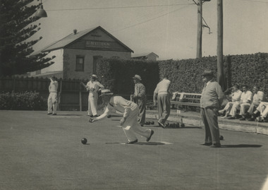
Photograph, Allen Farrow
Men playing Bowls on the green on the greens on the corner of Gipps and Bank StreetPhotograph of a sports ground that no longer exists on the corner of Gipps and Bank StreetBlack and white photograph of bowlers on the green on the corner of Gipps and Bank StreetOn back of photograph. Port Fairy Bowling Green. Building, Haylocks Carriage, Gobles Mill. S Brown, (Dake) Malone ? on back of photograph. Allen Farrow, 366 Bourke St, MU3422, Melbourne. For re-ordering please quote No 15 bowls, gipps street, bank street, bowling club -
 Vision Australia
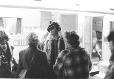
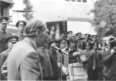
Image, 15/10/1979
October 15, 1979 was the very first publicly proclaimed White Cane Day in Victoria. Announced by Premier Hamer, onlookers were invited to learn more about the various societies in Victoria that assisted the blind and vision impaired. Barry Humphries was the guest of honour, and spoke with a small group before venturing out with his own white cane to test out Melbourne’s wet streets. Caravans were set up along Swanston Street to distribute information. The RAAF band played and a square dance exhibition was held by vision impaired dancers in Bourke Street. 13 B/W photographs w/ 20 negatives and 23 col. negativesOn the back of BRIP381.11 is a partially erased pencil description 'Kathy Zwald' and 'Doris Nothling".white cane day, barry humphries, doris nothling, kathy zwald -
 Vision Australia
Image, 15/10/1979
October 15, 1979 was the very first publicly proclaimed White Cane Day in Victoria. Announced by Premier Hamer, onlookers were invited to learn more about the various societies in Victoria that assisted the blind and vision impaired. Barry Humphries was the guest of honour, and spoke with a small group before venturing out with his own white cane to test out Melbourne’s wet streets. Caravans were set up along Swanston Street to distribute information. The RAAF Central band played and a square dance exhibition by The Lightfooters (a group ofvision impaired dancers) in Bourke Street. 12 B/W photographswhite cane day, raaf central band -
University of Melbourne, Burnley Campus Archives
Plan, [Historical Maps of Richmond Park], 1862-2000
(1) Proposed reserve for Horticultural & Experimental Garden in the Survey paddock Richmond. R.19A (1865). Shows Swan Street Extension. Gazettals 1877, 1887. (2) As (1). Half of map only Annotation by A. Purchas, 9 October, 1862. (3) Plan of Richmond park. A.L. Martin Authorised Surveyor, 31st August, 1872. [Dept. of lands & Survey Melbourne, J. Noone, 6th September 1872.] Map in 4 sheets. (4) Richmond Park. Surveyed by Geo. Black, Authorised Surveyor 13.8.91 (2 copies). (5) [Richmond Park] Shows road alignments gazetted 1871 & 1881 (part copy only - Neg. 18375). (6) City of Richmond Parish of Jika Jika County of Bourke. Department of lands & Survey, 1919 (annotations i.e. Melb. City Link, Amrad, etc. to 1994.) (7) Burnley gardens, 2000. Produced by P. Tulk, Institute of Land & Food Resources, Burnley College, 2000 (re area proposed for heritage listing.)richmond park, survey paddock -
Vision Australia
Audio (item) - Sound recording, Royal Victorian Institute for the Blind, Around the Institute: September 25, 2001
Around the Institute was a weekly program designed to keep clients and staff informed of events, activities and thoughts relating to low vision and blindness. It consisted of interviews undertaken by Jo Matthews, with sound engineer Ed Gamble, designed to inform, educate and explore on a variety of topics. September 25: BCA position on M40 taxi program – Helen Ferris, Braille Week – Michelle Bourke. royal victorian institute for the blind, radio shows -
Vision Australia
Audio (item) - Sound recording, Royal Victorian Institute for the Blind, Around the Institute: May 7, 2002
Around the Institute was a weekly program designed to keep clients and staff informed of events, activities and thoughts relating to low vision and blindness. It consisted of interviews undertaken by Jo Matthews-Lamb, Susan Thompson, Janet Cronin and Corey Nassau, with sound engineer Ed Gamble, designed to inform, educate and explore on a variety of topics. May 7: Fundraising - Michelle Bourke, Queen Mother and all things Royal - Jennie D’Ambra, VisEquip – Lisa Morales, Martin Stewart. royal victorian institute for the blind, radio shows -
Vision Australia
Audio (item) - Sound recording, Royal Victorian Institute for the Blind, Around the Institute: August 27, 2002
Around the Institute was a weekly program designed to keep clients and staff informed of events, activities and thoughts relating to low vision and blindness. It consisted of interviews undertaken by Jo Matthews-Lamb, Susan Thompson, Janet Cronin and Corey Nassau, with sound engineer Ed Gamble, designed to inform, educate and explore on a variety of topics. August 27: A Day in the Life of the Northern Region - Barb McKenzie, Upcoming events – Michelle Bourke.royal victorian institute for the blind, radio shows -
 Port Fairy Historical Society Museum and Archives
Photograph, Cornelius Bourke Mayor 1906
... Street Port Fairy great-ocean-road Cornelius Bourke Mayor 1906 ...Cornelius Bourke Mayor 1906Black and white photographbelfast, mayor, portrait, government, shire, council, municipal, local-government -
Canterbury History Group
Letter - Young's Milk Bar and Dairy, 1997
Correspondence between Sue Barnett of Surrey Hills Histoical Society and Carmel Bourke (nee Young) relating to Youngs Milk Bar in Highfield Road, Canterbury, and dairy at 313 Canterbury Road Canterburycanterbury, highfield road, canterbury road, youngs milk bar, youngs dairy, grays bakery, young family, dairies, shops, milk bars, barnett> susan -
 Hawthorn Historical Society
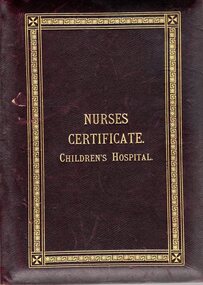
Certificate, Nurses Certificate Children's Hospital, 1916
Harriet Cecilia Hordern Williams (1889 - 1968) was the grand-daughter of William Hordern (1830 - 1881) and Cecelia Monger (1830 - 1914). William Hordern was the sixth of seven children of Anthony Hordern Snr. who established the Anthony Hordern & Sons department store in Sydney which operated from 1923 to 1970. Harriet's mother Cecilia (1854 - 1934) was married to Christopher Williams. Harriet's uncle William was appointed commissioner of the Supreme Court of South Australia in 1903. Her cousin Doris Amelia Hordern (1889 - 1970), as Doris Blackburn won the Federal seat of Bourke in 1946 following the death of her husband who had previously held the seat. This branch of the Hordern family has a strong connection to Hawthorn through their home "Stramshall" in Auburn Road Hawthorn and also with the Auburn Baptist Church. Harriet Williams enlisted in the Australian Army Nurse in December 1916 and served as a Staff Nurse until her marriage in London in 1919. This certificate is significant to the history of Hawthorn and Australia through its connection with the Hordern family, the home Stramshall in Hawthorn and with the Auburn Baptist Church. It is significant to the history of the Royal Children's Hospital Melbourne as an example of early 20th century training protocol, in the persons who signed the certificate and the photographs of the hospital buildings of that time. Leather bound certificate of two pages hinged together as a book. Gold lettering embossed on the front. Gold ornamental border embossed on front and back. Inside a personalised presentation certificate on one page. Second page has photographs of the Melbourne Children's Hospital circa 1916.Certificate Reads: Childrens Hospital/ Training School For Nurses/ Melbourne October 5th 1916 This is to certify that Harriet Cecilia Hordern Williams has attended the prescribed course of Three Years Teaching at the Training School for Nurses in connection with the Childrens Hospital and has passed the examinations necessary for registration as a TRAINED NURSE. Signed by: Lalla Williams - Signature of Nurse M. J Turnbull, President Cora C. Oakden , Honorary Secretary Examiners: F. Hobill Cole M.D. A. Jeffreys Wood M.D. E. Alan Mackay M.B.B.S. Douglas Stephenson M.D.M.S. A. E. Rowden White M.D. Stuart W. Ferguson M.D. Captions on the photographs read: Convalescent Home Brighton Nurses Home Children's Hospital Princess May Pavilion Red Cross with banner beneath reading BY LABOR MUST THE PRIZE BE WON Printed on certificate: Sands & McDougall Limited Melb.childrens hospital, certificate, nurse, hordern, williams, hawthorn, harriet williams, lalla williams, rowden white, cora oakden, hobill cole, jeffreys wood, mary jane turnbull, alan mackay, douglas stephenson, stuart ferguson, brighton convalescent home, princess may pavilion -
 Melton City Libraries
Map, Streets of Melton, 1963
MELTON’S STREETS Heritage Week 2014 What’s in a Name? Alphabetical List Aboriginal place names, Early Family Names and landowners, Agricultural, Shop and Commercial premises, Places and Events Melton & District Historical Society Street Naming Project 1972 – c 1998 Suburb Name – KURUNJANG - Kirkton, 1972, Brookfield, West, 1988 Melton and Town Centre - A joint collaboration with the Shire of Melton and Subdivision Developers ARNOLD Court – Family house - Arnolds Creek ALKEMADE Drive Family – Lime kilns Coimadia ALEXANDRA Street 1902 – Corination of King Edward VII and Queen Alexandra AVIATOR Place Event, location of plane crash – Jimmy Melrose 1936 Adina ?Annibee - Anniba? Agricultural Avon court .. .. BAKERY Square - Location of Jongebloed shop, bakehouse and stables BALUK Place Aboriginal BARLEYCORN Place Agricultural BILLING Place Name of Jimmy Melrose Uncle Noel Pemberton Billing BLACKWOOD Drive - Alexander Blackwood 1860c Registrar BARRIES Road C. E. Barrie “Darlingsford” farmer 1911, chaff mill owner BROOKLYN Road Staughton family residence. 1875 – Dismantled c 193? CAHILL Drive Family - Glenville Dairy CAMERON Court Family Canopus Place ? CANALLAN Drive Early Surveyor CAMPBELL Court Aviation – Melrose passenger 6th July 1936 CARBERRY Drive Michael, early landowner family CAREW Court Edward and Michael. Royal Hotel. Vera (Carew) Forran Singer - Opera CASEY Court Family CASHIN Court Family CHEVIOT Court Agriculture, breed of sheep CHESNEY Road was re named ( Minns Road being duplicated c 1973) CHRISTINA Crescent Christina McPherson, daughter of James and Mary Mary McPherson. Died 1955 aged 85 years COLLYER Close a deleted street (parallel to Yuille) re-used CORRIEDALE Road Breed of sheep CORR Court Teacher at first school, landowner CROXTON Court Name of the Hornbuckle and Knox family home DALEY Court - William Daley and family 1865 Bootmaker High Street DARLINGSFORD Boulevard - Name of early homestead Thomas B Darling 1853 DJERRIWARRH Court - Parish County of Bourke - very early map. DODEMAIDE Place Early land owners - Melton Football Team had 6 brothers playing c 1924 DONALD Court McPherson family 6 generations in Melton in 1936 DOUGAL Court DUNCAN Court .. .. DUNVEGAN Circuit Home of the McPherson family, castle Isle of Skye Name of bluestone house Smith Street (now at Willows) EMIL Court Jongebloed family EXELL Avenue Farming family Melton Sth- Closer Settlement 1907 EXFORD Road Exe former name of the Werribee river FARMER Court Name of early postmistress FERRIS Road John Ferris Farmer HANNAH Close First name of Hannah Watts – midwife HAYBALE Place Agricultural HELDER Court Early surveyor J Helder Wedge map HEWSON Street Winston Hewson Shire Engineer – check title c 1960 HENRY Street Township map c 1860 HESTON Street Heston Phoenix – C.J. Melrose plane HILDEGARDE Court Jimmy Melrose’s mothers name HOMESTEAD Close HORNBUCKLE Cres Farmers. Three members of family - Shire Presidents HURLEY Street Farmers IAIN Court Descendent of James and Mary McPherson JAMES MELROSE Drive Name appears on 2013 Melton information map JANG Place KURUN – jang KIRKTON Drive Name of the McPherson family home Toolern Vale Road KIRWIN Street Michael early landowners (deleted for freeway construction) KILPATRICKS Road Deleted when Barries Road was extended across Station Rd KOROROIT Court Early map, Parish of Kororoit. Creek name KNOX Circuit Family – Hornbuckle “Croxton Park” KURRUNJANG Drive Aboriginal name for people of the red earth – Suburb name Lara Place ? LLOYD Court Garage owners High Street. Laura lived to 100 years D 1955 LUBY Court John Luby – Crown Grant Land Title LITTLE Court MANNING Avenue Richard, hotel owner 1891 MARGARET Drive McPherson family McDONALD Street Melton South family name McKENZIE Street Township c1860 MORROW Street Early name MOWBRAY Crescent Name of English Melton, popularly believed origin of Melton MYERS Court Early setters c 1866 Crown Grant Land Title NIMMO Street Early name NIXON Street Name submitted by Mary nee Nixon Collins c1985 OLDERSHAW Road Early builder PALMERSTON Street Early township map c 1860 PEART Court Early name PENNYROYAL Avenue Plant growing by the creek. Early name used for the Toolern Toolam Creek PINKERTON Street Family name and early street map PINNACLE Crescent Agricultural - type of wheat PHOENIX Circuit C.J. Melrose Phoenix Heston Plane 2013 map PRATT Family PRIOR Court PYKE Place Brothers – early settlement 1838 RADFORD Court Land owners and business operators. Former Royal Hotel Grocer High Street demolished 1970 RAGLAN Court Hotel 19th century Lord Raglan RALEIGHS Road Oliver Reierson family (Norweigen) Shopkeeper – Dressmakers RIDDELL Drive (misspelt Riddle) Resident and land owner RODERICK Road McPherson family – a re occurring name ROLLAND Court Jones family ROSS Court Daniel. Landowner. Agnes Ross music teacher RUSSELL Court Robert. Early land surveyor of Melton 1853 RYAN Court Family early landowner. Member of the 1862 Road Board SHEBLER Place Augustus early Melton resident – Golden Fleece Hotel SHEEPFOLD Court Farming SHERWIN Court Sherwin Street earliest Township map– became Golf course SMITH Street Early township map. STRATHULLOH Circuit Strathtulloh Homestead. STAUGHTON Street Family – LARGE land owners Strachan ? SWANEY Court Marie Swaney earlier resident of Strathtulloh. SUTHERLAND Family name TOOLERN Street TOOLAM – TOOLERN Creek TULLIDGE St Road marked on 1861 map UNITT Street Early Township c 1860 WALLACE Square Cr Jack Wallace 5 terms as President 46 years unopposed WATTS Court Hannah Watts – midwife, cottage hospital WALSINGHAM Name of house of Minns family. From Walsingham Norfolk England WESTLEY Place Name of Jimmy Melrose Percival Gull Plane WESTLAKE Drive Early resident WHICKHAM Street Family Name Melton South WILSON Road Albert, Melton South YUILLE Street William Cross, early landowner, Rockbank run Zoomed in section of Melton Streets including Church and High Streetlandscapes of significance -
 Melton City Libraries
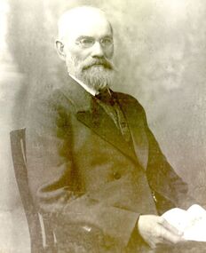
Newspaper, Melbourne A.A. Club, 1903
"Captain Simon Thomas Staughton was the son of Simon Thomas Staughton MLA who had built the mansion Eynesbury on his share of the Exford property inherited from his father Simon Staughton, the original 1840s Werribee River squatter. When the land was sold, Simon’s Exford station extended from Mt Cotterell to the Brisbane Ranges. ST Staughton (senior) was a reputedly the public spirited member of the family in his generation, being a member of the first Roads Board (and Melton Shire President in 1867), a JP, Magistrate and MLA for Bourke from 1883 until his death in 1901, whereupon his son became the MLA for Bourke. Captain ST Staughton had earlier been chosen as a member of a contingent of Victorian Mounted Riflemen sent to England for Queen Victoria’s Diamond Jubilee (1897), and was later a member of King Edward’s coronation escort. In October 1899 he had sailed for South Africa with other Mounted Riflemen from Victorian and NSW to take part in the Boer War. There he was awarded the DSO. He died of peritonitis in 1903, aged 27. He was buried in Boroondara Cemetery after a full military funeral, in which the coffin was borne on a gun carriage drawn by four black horses. All local newspapers reported eloquently on the funeral, and the late Captain’s virtues. The Staughton Memorial Lamp was given to the town by his young widow in 1903. In addition a window in the (former) Christ Church bore the inscription ‘This window is erected by his brother soldiers in loving memory of Captain S Tom Staughton, DSO, ADC, MLA’. The Staughton family had been prominent benefactors of the Church, whose altar rails were also inscribed to the much respected Captain, along with a memorial stone in the new chancel. In the 1970s the memorial was within one of four fenced tree plantations, probably erected and planted in the 1920s or 30s. When High Street and its service roads were redesigned in the 1970s the plantations were completely removed, and the Melton and District Historical Society was successful in having the memorial moved about 50 metres east to its present location". The Weekly Times article about a gift from Tom Staughtonlocal identities -
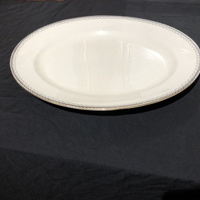 Mont De Lancey
Carving Dish, Wedgewood & Co. Ltd, Circa 1900
Gift to Wandin Museum by Mrs. K. Bourke of Hawthorn.Wedgewood china, white carving dish, with black decoration around the rim."Wedgewood & Co. Ltd. England"dishes -
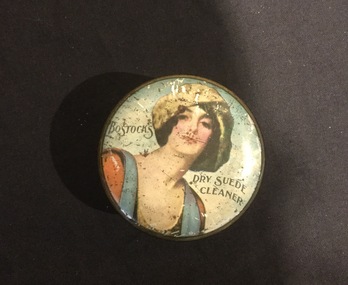 Mont De Lancey
Tin, Bostocks
On Loan from Mrs. K. Bourke c/o Mrs. H. N. LordDecorative round tin with lady on lid.Bostocks - dry suede cleaner. White - 2oz. Contents - Black 1 oz.tins, containers, cleaning products