Showing 344 items matching "city traffic"
-
 Melbourne Tram Museum
Document - Memorandum, Melbourne & Metropolitan Tramways Board (MMTB), Parade of RAN personnel through city streets, 8/02/1946 12:00:00 AM
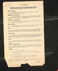
... Parade of RAN personnel through city streets Friday 8 February 1946 Letter from HS Wootton, Town Clerk, City of Melbourne, describing arrangements for the parade. Letter from W Simpson Assistant Manager to officers concerned. 5 memos from JM Harry, Dist Traffic Supt SS regarding tram arrangements to various inspectors. ...Parade of RAN personnel through city streets Friday 8 February 1946 Letter from HS Wootton, Town Clerk, City of Melbourne, describing arrangements for the parade. Letter from W Simpson Assistant Manager to officers concerned. 5 memos from JM Harry, Dist Traffic Supt SS regarding tram arrangements to various inspectors. ...Parade of RAN personnel through city streets Friday 8 February 1946 Letter from HS Wootton, Town Clerk, City of Melbourne, describing arrangements for the parade. Letter from W Simpson Assistant Manager to officers concerned. 5 memos from JM Harry, Dist Traffic Supt SS regarding tram arrangements to various inspectors. Memo dated 4th February 1946.Notations written in pencil on several memos.trams, tramways, events, port melbourne, port melbourne depot, hanna st depot, malvern depot, glenhuntly tram depot, camberwell depot -
 Melbourne Tram Museum
Administrative record - Circular, Department of Defence, Melbourne and Metropolitan Tramways Board (MMTB), Defence Week, Jan/Feb 1934
... . - Newspaper clipping - Arrangements for March - provides details and route of march through the city. 2. - Memo from Assistant Manager to Dist. Traffic Supts NS & SS, dated 5 Feb 1934, providing details of Defence Week, with plan of march. 3. - 10 pages of memos to senior inspectors for shunting arrangements. 4. - 3rd Military District Circular No 4/1934 - describing the march. 5 pages 5. - Programme for week - 2 page program of Defence Week activities.... - Newspaper clipping - Arrangements for March - provides details and route of march through the city. 2. - Memo from Assistant Manager to Dist. Traffic Supts NS & SS, dated 5 Feb 1934, providing details of Defence Week, with plan of march. 3. - 10 pages of memos to senior inspectors for shunting arrangements. 4. - 3rd Military District Circular No 4/1934 - describing the march. 5 pages 5. - Programme for week - 2 page program of Defence Week activities Defence Week Administrative record Circular Department of Defence, Melbourne and Metropolitan Tramways Board (MMTB) JH Crombie, Simpson, Briggs, Hickingbotham, Mr Eakins, Miller ...Defence Week - Monday 12/2/34 to Saturday 17/2/34 1. - Newspaper clipping - Arrangements for March - provides details and route of march through the city. 2. - Memo from Assistant Manager to Dist. Traffic Supts NS & SS, dated 5 Feb 1934, providing details of Defence Week, with plan of march. 3. - 10 pages of memos to senior inspectors for shunting arrangements. 4. - 3rd Military District Circular No 4/1934 - describing the march. 5 pages 5. - Programme for week - 2 page program of Defence Week activitiestrams, tramways, instructions, events -
 Melbourne Tram Museum
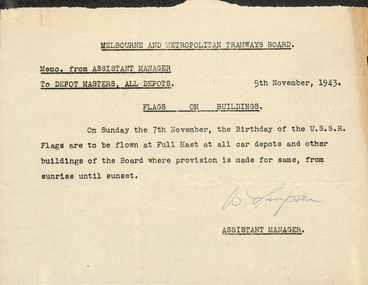
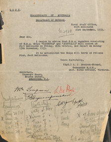
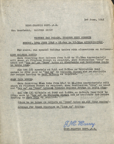
Document - Memorandum, Melbourne & Metropolitan Tramways Board (MMTB), Procession of Australia - Soviet Friendship League, Nov. 1943
... Letter from HS Wootton, Town Clerk, City of Melbourne, about the procession of ATC Cadets through city streets. 5 memos from JM Harry, Dist Traffic Supt SS regarding tram arrangements to various inspectors. ...Letter from HS Wootton, Town Clerk, City of Melbourne, about the procession of ATC Cadets through city streets. 5 memos from JM Harry, Dist Traffic Supt SS regarding tram arrangements to various inspectors. ..."Procession of Australia - Soviet Friendship League Sunday 7 November 1943 Memo from Assistant Manager to Depot Masters about flying flags on depots and other buildings. Letter from HS Wootton, Town Clerk, City of Melbourne, about the procession of ATC Cadets through city streets. 5 memos from JM Harry, Dist Traffic Supt SS regarding tram arrangements to various inspectors. Memos dated November 1943.Notations written in pencil on several memos.trams, tramways, procession, soviet friendship league, events -
 Melbourne Tram Museum
Document - Memorandum, Melbourne & Metropolitan Tramways Board (MMTB), "Parade of Allied Service Units", 2/11/1943 12:00:00 AM
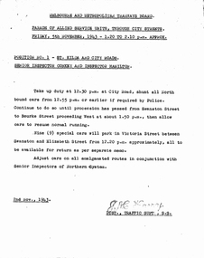
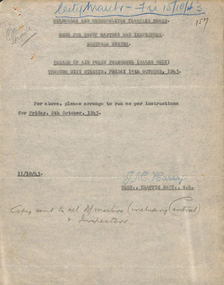
... Parade of Allied Service Units, Through City Streets Friday 5th November 1943 - 1.20 to 2.10 pm 9 memos to various inspectors across several depots for the above event from JM Harry , Dist Traffic Superintendent. 2 copies of letter from HS Wootton, Town Clerk, dated 28 October 1946, titled "Arrangements for "Allies' Day" March of Service Units Through the City Streets on Friday 5th November 1943" Australian Military Forces, Vic L of C March Order No. 8/43, dated 1 Nov 43....Parade of Allied Service Units, Through City Streets Friday 5th November 1943 - 1.20 to 2.10 pm 9 memos to various inspectors across several depots for the above event from JM Harry , Dist Traffic Superintendent. 2 copies of letter from HS Wootton, Town Clerk, dated 28 October 1946, titled "Arrangements for "Allies' Day" March of Service Units Through the City Streets on Friday 5th November 1943" Australian Military Forces, Vic L of C March Order No. 8/43, dated 1 Nov 43. ...Parade of Allied Service Units, Through City Streets Friday 5th November 1943 - 1.20 to 2.10 pm 9 memos to various inspectors across several depots for the above event from JM Harry , Dist Traffic Superintendent. 2 copies of letter from HS Wootton, Town Clerk, dated 28 October 1946, titled "Arrangements for "Allies' Day" March of Service Units Through the City Streets on Friday 5th November 1943" Australian Military Forces, Vic L of C March Order No. 8/43, dated 1 Nov 43."Mr Harry" written in pencil on march orders.trams, tramways, letters, instructions, events, st kilda rd, city road, swanston st, bourke st, franklin st, elizabeth st, victoria st, clarendon st, queens bridge, collins st, hanna st, spencer st, king st, market st -
 Melbourne Tram Museum
Document - Memorandum, Melbourne & Metropolitan Tramways Board (MMTB), "Parade of Returned AIF Personnel, through city streets", 15/11/1943 12:00:00 AM
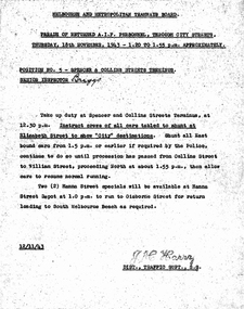
... Parade of Returned AIF Personnel, Through City Streets Thursday 18th November 1943 - 1.20 to 1.55 PM 1 - Several memos from JM Harry, Dist Traffic Supt, to depots for tram arrangements for above event. ...Provides details for parking and shunting of tramcars. 2 - Letter from HS Wootton, Town Clerk, to M&MTB regarding traffic and march arrangements for above event. "Parade of Returned AIF Personnel, through city streets" Document Memorandum Melbourne & Metropolitan Tramways Board (MMTB) JM Harry, Snr Insp Williams, Snr Insp Downie, Inspector Briggs ...Parade of Returned AIF Personnel, Through City Streets Thursday 18th November 1943 - 1.20 to 1.55 PM 1 - Several memos from JM Harry, Dist Traffic Supt, to depots for tram arrangements for above event. Provides details for parking and shunting of tramcars. 2 - Letter from HS Wootton, Town Clerk, to M&MTB regarding traffic and march arrangements for above event.trams, tramways, letters, instructions, events, parades, world war 2, city rd, swanston st, victoria st, hawthorn depot, camberwell depot -
 Melbourne Tram Museum
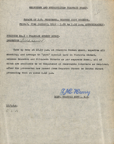
Document - Memorandum, Melbourne & Metropolitan Tramways Board (MMTB), Parade of RN personnel through city streets, 17/01/1946 12:00:00 AM
... Parade of RN personnel through city streets Friday 25th January 1946, 1.20 to 1.55PM Memo from JM Harry, Dist Traffic Supt SS regarding tram arrangements for position no 3 - Franklin St Shunt. ...Parade of RN personnel through city streets Friday 25th January 1946, 1.20 to 1.55PM Memo from JM Harry, Dist Traffic Supt SS regarding tram arrangements for position no 3 - Franklin St Shunt. ...Parade of RN personnel through city streets Friday 25th January 1946, 1.20 to 1.55PM Memo from JM Harry, Dist Traffic Supt SS regarding tram arrangements for position no 3 - Franklin St Shunt. Memo dated 17th January 1946.Notations written in pencil on several memos.trams, tramways, events, franklin st, victoria st, swanston st, elizabeth st, bourke st -
 Melbourne Tram Museum
Document - Memorandum, Melbourne & Metropolitan Tramways Board (MMTB), Third Annual Horse Gymkhana, 20/03/1934 12:00:00 AM
... Traffic Supts, NS & SS, about a procession of horses and vehicles through the city....Traffic Supts, NS & SS, about a procession of horses and vehicles through the city. ...Third Annual Horse Gymkhana Memo from Assistant Manager to Dist. Traffic Supts, NS & SS, about a procession of horses and vehicles through the city."Mr Simpson, for your information" written in black ink, top left corner. "Inspectors please note. WJ 3/4/34" written in red pencil in lower half.trams, tramways, instructions, events -
 Melbourne Tram Museum
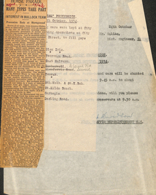
Document - Memorandum, Melbourne & Metropolitan Tramways Board (MMTB), "Back to Horse" Procession, 24/10/1934 12:00:00 AM
... Traffic Superintendent S.S. Note paper pinned to front with inscription: "Back to Horse" Procession. - Saturday 27 October, 1934" Typed details of tram shunting at City Rd and Flinders St. ...Melbourne Tram Museum 8 Wallen Road Hawthorn melbourne Trams tramways Instructions Events Showgrounds City Rd Flinders St Numerous notes written in black pencil across memos Memorandum - one typed sheets (8"x10.5") - titled "Back to Horse" Procession. - Saturday 27 October, 1934 from DJ Davidson, District Traffic Superintendent S.S. ...Memorandum - one typed sheets (8"x10.5") - titled "Back to Horse" Procession. - Saturday 27 October, 1934 from DJ Davidson, District Traffic Superintendent S.S. Note paper pinned to front with inscription: "Back to Horse" Procession. - Saturday 27 October, 1934" Typed details of tram shunting at City Rd and Flinders St. "Pencil alt 28/9/35 1935" written in black pencil. Several pencil crosses next to times. Camberwell and Glenferrie Rd crossed out and rewritten in black pencil. One newspaper clipping titled "Horse Parade - Many Types take Part - Interest in Bullock Team - Procession Ends at Showground". "Argus" & "29/10/34" written in red ink.Numerous notes written in black pencil across memostrams, tramways, instructions, events, showgrounds, city rd, flinders st -
 Melbourne Tram Museum
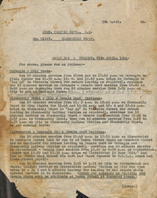
Document - Memorandum, Melbourne & Metropolitan Tramways Board (MMTB), "ANZAC Day - Tuesday 25th April 1944", 5/4/1944
... Melbourne Tram Museum 8 Wallen Road Hawthorn melbourne Trams tramways Instructions ANZAC Day Glenhuntly Depot "Run 3 specials at 8.7 8.17 & 8.27am" "returns to city & depot" written in pencil ANZAC Day - Tuesday 25th April 1944 Memo from Dist Traffic Supt SS to Mr Cliff, Glenhuntly Depot, regarding tram arrangements for ANZAC Day. ...ANZAC Day - Tuesday 25th April 1944 Memo from Dist Traffic Supt SS to Mr Cliff, Glenhuntly Depot, regarding tram arrangements for ANZAC Day. (single page only, subsequent pages missing)"Run 3 specials at 8.7 8.17 & 8.27am" "returns to city & depot" written in penciltrams, tramways, instructions, anzac day, glenhuntly depot -
 Melbourne Tram Museum
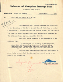
Letter, Melbourne & Metropolitan Tramways Board (MMTB), Parade of RAN personnel through city streets, Thursday 21 October 1943, Oct. 1943
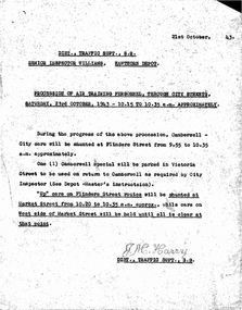
... Parade of RAN personnel through city streets, Thursday 21 October 1943 Letter from GJ Dean, Acting Town Clerk, City of Melbourne, describing arrangements for the parade. Dated 9th October 1943. 2 memos from JM Harry, Dist Traffic Supt SS regarding tram arrangements to Mr Bell, Asst Per Way Engineer and Depot Masters. ...Memo from JM Harry, Dist Traffic Supt SS to Assistant Manager regarding shunting operations. Memos dated 18th & 19th October 1943. Parade of RAN personnel through city streets, Thursday 21 October 1943 Letter Melbourne & Metropolitan Tramways Board (MMTB) JM Harry, Mr Bell, GJ Dean ...Parade of RAN personnel through city streets, Thursday 21 October 1943 Letter from GJ Dean, Acting Town Clerk, City of Melbourne, describing arrangements for the parade. Dated 9th October 1943. 2 memos from JM Harry, Dist Traffic Supt SS regarding tram arrangements to Mr Bell, Asst Per Way Engineer and Depot Masters. Memo from JM Harry, Dist Traffic Supt SS to Assistant Manager regarding shunting operations. Memos dated 18th & 19th October 1943.Notations written in blue pencil on letter., "City March - Thurs 21/10/43" written in red penciltrams, tramways, events, ymca, st kilda rd, sturt st -
 Melbourne Tram Museum
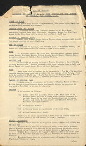
Document - Memorandum, Melbourne & Metropolitan Tramways Board (MMTB), "Victory Day Parade, through city streets", Apr. 1946
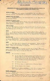
... Parade of units of victory march personnel through city streets Monday 10 June 1946 - 11:00AM to 12:30PM Memos from JM Harry, Dist Traffic Supt SS regarding tram arrangements to Mr Mazolettti, Malvern Depot, Mr McLean, Hanna St, Mr Cliff, Glenhuntly Depot, Mr Fisher, Hawthorn Depot, Mr Head, Camberwell, Mr Lawrence, Port Melbourne, Mr McRae, Central Bus Garage Memos dated 3 June 1946. ...Parade of units of victory march personnel through city streets Monday 10 June 1946 - 11:00AM to 12:30PM Memos from JM Harry, Dist Traffic Supt SS regarding tram arrangements to Mr Mazolettti, Malvern Depot, Mr McLean, Hanna St, Mr Cliff, Glenhuntly Depot, Mr Fisher, Hawthorn Depot, Mr Head, Camberwell, Mr Lawrence, Port Melbourne, Mr McRae, Central Bus Garage Memos dated 3 June 1946. ...Parade of units of victory march personnel through city streets Monday 10 June 1946 - 11:00AM to 12:30PM Memos from JM Harry, Dist Traffic Supt SS regarding tram arrangements to Mr Mazolettti, Malvern Depot, Mr McLean, Hanna St, Mr Cliff, Glenhuntly Depot, Mr Fisher, Hawthorn Depot, Mr Head, Camberwell, Mr Lawrence, Port Melbourne, Mr McRae, Central Bus Garage Memos dated 3 June 1946. Letter from JM Harry regarding bus services. Letter from HS Wootton, town clerk. Documents from ADFNotations written in pencil on memo.trams, tramways, events, parades, malvern depot, hanna st depot, hawthorn depot, central bus garage -
 Melbourne Tram Museum
Document - Memorandum, Melbourne & Metropolitan Tramways Board (MMTB), "Arrangements for Air Training Corps Parade through the city streets on Saturday 15th April 1944", Apr. 1944
... "Arrangements for Air Training Corps Parade through the city streets on Saturday 15th April 1944" Letter from HS Wootton, town clerk advising of event. Several memos from JM Harry, Dist Traffic Supt SS regarding tram and bus arrangements...."Arrangements for Air Training Corps Parade through the city streets on Saturday 15th April 1944" Letter from HS Wootton, town clerk advising of event. Several memos from JM Harry, Dist Traffic Supt SS regarding tram and bus arrangements. ..."Arrangements for Air Training Corps Parade through the city streets on Saturday 15th April 1944" Letter from HS Wootton, town clerk advising of event. Several memos from JM Harry, Dist Traffic Supt SS regarding tram and bus arrangements.Notations written in pencil on memo.trams, tramways, events, parades -
 Melbourne Tram Museum
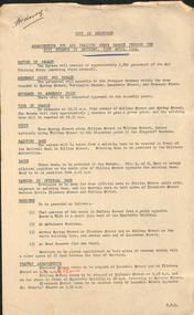
Document - Memorandum, Melbourne & Metropolitan Tramways Board (MMTB), "Procession of Combined Women's Services through city streets on Friday 14th April 1944", Apr. 1944
... Procession of Combined Women's Services through city streets on Friday 14th April 1944 1 memo from JM Harry, Dist Traffic Supt SS to Mr Fischer, Assistant Per Way Engineer regarding tram arrangements. 2 hand written notes...Procession of Combined Women's Services through city streets on Friday 14th April 1944 1 memo from JM Harry, Dist Traffic Supt SS to Mr Fischer, Assistant Per Way Engineer regarding tram arrangements. 2 hand written notes "Procession of Combined Women's Services through city streets on Friday 14th April 1944" Document Memorandum Melbourne & Metropolitan Tramways Board (MMTB) JM Harry, Mr Fischer ...Procession of Combined Women's Services through city streets on Friday 14th April 1944 1 memo from JM Harry, Dist Traffic Supt SS to Mr Fischer, Assistant Per Way Engineer regarding tram arrangements. 2 hand written notesNotations written in pencil on memo.trams, tramways, events, parades -
 Melbourne Tram Museum
Document - Memorandum, Melbourne & Metropolitan Tramways Board (MMTB), "Parade of Returned AIF Personnel through city streets, Wednesday 18 November 1943", Nov. 1943
... "Parade of Returned AIF Personnel through city streets, Wednesday 18 November 1943" 2 memos from JM Harry, Dist Traffic Supt, to depots for tram arrangements for above event....Melbourne Tram Museum 8 Wallen Road Hawthorn melbourne Trams tramways Events Parades World War 2 Pencil comments to Mr Harry to note "Parade of Returned AIF Personnel through city streets, Wednesday 18 November 1943" 2 memos from JM Harry, Dist Traffic Supt, to depots for tram arrangements for above event. ..."Parade of Returned AIF Personnel through city streets, Wednesday 18 November 1943" 2 memos from JM Harry, Dist Traffic Supt, to depots for tram arrangements for above event.Pencil comments to Mr Harry to notetrams, tramways, events, parades, world war 2 -
 Melbourne Tram Museum
Document - Memorandum, Melbourne & Metropolitan Tramways Board (MMTB), "Parade of Air Force Personnel (Males Only) through city streets Friday 15th October, 1943", Oct. 1943
... "Parade of Air Force Personnel (Males Only) through city streets Friday 15th October, 1943" Three memos from JM Harry, Dist Traffic Supt SS regarding tram arrangements for above event. ..."Parade of Air Force Personnel (Males Only) through city streets Friday 15th October, 1943" Three memos from JM Harry, Dist Traffic Supt SS regarding tram arrangements for above event. ..."Parade of Air Force Personnel (Males Only) through city streets Friday 15th October, 1943" Three memos from JM Harry, Dist Traffic Supt SS regarding tram arrangements for above event. Letter from GJ Dean, acting town clerk, dated 9 Oct '43, with attachment of march orders, dated 15 Oct '43.Notations written in pencil on memo.trams, tramways, events, parades -
 Melbourne Tram Museum
Document - Memorandum, Melbourne & Metropolitan Tramways Board (MMTB), "Parade of Air Training Personnel, through city streets Saturday 23rd October, 1943", Oct. 1943
... "Parade of Air Training Personnel, through city streets Saturday 23rd October, 1943" Seven memos from JM Harry, Dist Traffic Supt SS regarding tram arrangements for above event...."Parade of Air Training Personnel, through city streets Saturday 23rd October, 1943" Seven memos from JM Harry, Dist Traffic Supt SS regarding tram arrangements for above event. ..."Parade of Air Training Personnel, through city streets Saturday 23rd October, 1943" Seven memos from JM Harry, Dist Traffic Supt SS regarding tram arrangements for above event.Notations written in pencil on memo.trams, tramways, events, parades -
 Melbourne Tram Museum
Document - Memorandum, Melbourne & Metropolitan Tramways Board (MMTB), Parade of Combined Women's Services (Navy, Army & Air Force), Oct. 1943
... City of Melbourne regarding arrangements for parade. Letter dated 9 October 1943. 2 copies of memo from Simpson, Assistant Manager to officers concerned regarding tram and bus arrangements. Memo dated 13 October 1943 Memos from Dist Traffic...City of Melbourne regarding arrangements for parade. Letter dated 9 October 1943. 2 copies of memo from Simpson, Assistant Manager to officers concerned regarding tram and bus arrangements. Memo dated 13 October 1943 Memos from Dist Traffic ...Parade of Combined Women's Services (Navy, Army & Air Force) Through City Streets, Tuesday 19th October 1943 2 copies of letter from GJ Dean, Acting Town Clerk, City of Melbourne regarding arrangements for parade. Letter dated 9 October 1943. 2 copies of memo from Simpson, Assistant Manager to officers concerned regarding tram and bus arrangements. Memo dated 13 October 1943 Memos from Dist Traffic Supt SS, JM Harry to Assistant Manager, Mr Bell and depot masters and inspectors. Memos dated 18 October 1943"City March - Tues 19/10/43" written in blue pencil across top of letter and in red pencil across one memo.trams, tramways, letters, instructions, events, world war i -
 Melbourne Tram Museum
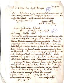
Document - Report, Tramway Board, "Proposed Flying City Shunt", 11/09/1917 12:00:00 AM
... Savage, Assist Traffic Manager titled "Proposed Flying City Shunt". Report suggests that improved shunting arrangements are needed at Collins and Spencer St due to increased traffic. ...Savage, Assist Traffic Manager titled "Proposed Flying City Shunt". Report suggests that improved shunting arrangements are needed at Collins and Spencer St due to increased traffic. ...Report - hand made on very thin paper, almost rice paper, 3 pages + cover note of 2/11/1921 to Mr. Wilcox, General Manager from Mr. C. W. Young and W. A. Savage, Assist Traffic Manager titled "Proposed Flying City Shunt". Report suggests that improved shunting arrangements are needed at Collins and Spencer St due to increased traffic. Notes cars can be shunted in abnormal conditions in 40 seconds. Normal shunting was 60secs it appears. Report gives details of the costs and the shunting times taken to turn cable sets around. The cover note of 2/11/1921, re-submits the report to Mr Dix from a person (can read the signature) from the Fitzroy Power House. Last page was scanned separately as a jpg file. Dated 11/9/1917Has been stamped "Copy" in two places.trams, tramways, cable trams, track, collins st, shunting -
 Melbourne Tram Museum
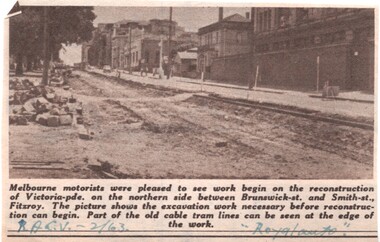
Newspaper, Royal Automobile club of Victoria (RACv), removal of the cable tram track in Victoria Parade, 1963 to 1971
... Set of 8 newspaper clippings, mid 1960's concerning traffic control and congestion issues. .1 - Royal auto - 2/1963 - reporting on the removal of the cable tram track in Victoria Parade between Brunswick and Smith St, noting the old cable tram lines. .2 - Royal auto - 1/65 - Photo of Toorak Road Toorak with a tram and parked cars. .3 - Royal auto - 8/64 on Chapel St with W2 324 (route 77, City) showing the impact of parked cars at 8.45am and a motor car trying to squeeze past. .4 - Royal auto - 9/64, Burke Road Camberwell, showing the impact of parked cars and trams. ...Melbourne Tram Museum 8 Wallen Road Hawthorn melbourne Trams tramways Congestion Traffic Control RACV Chapel St Toorak Road Victoria Parade Cable Trams W2 class SW6 class Burke Road Camberwell Route 77 Route 7 Swanston St Kew Junction Route 74 Hartwell Johnston St Buses tram 324 tram 641 tram 934 Extensive notes on the rear of the photo, see image i2 Set of 8 newspaper clippings, mid 1960's concerning traffic control and congestion issues. .1 - Royal auto - 2/1963 - reporting on the removal of the cable tram track in Victoria Parade between Brunswick and Smith St, noting the old cable tram lines. .2 - Royal auto - 1/65 - Photo of Toorak Road Toorak with a tram and parked cars. .3 - Royal auto - 8/64 on Chapel St with W2 324 (route 77, City) showing the impact of parked cars at 8.45am and a motor car trying to squeeze past. .4 - Royal auto - 9/64, Burke Road Camberwell, showing the impact of parked cars and trams. ...Set of 8 newspaper clippings, mid 1960's concerning traffic control and congestion issues. .1 - Royal auto - 2/1963 - reporting on the removal of the cable tram track in Victoria Parade between Brunswick and Smith St, noting the old cable tram lines. .2 - Royal auto - 1/65 - Photo of Toorak Road Toorak with a tram and parked cars. .3 - Royal auto - 8/64 on Chapel St with W2 324 (route 77, City) showing the impact of parked cars at 8.45am and a motor car trying to squeeze past. .4 - Royal auto - 9/64, Burke Road Camberwell, showing the impact of parked cars and trams. Photo includes SW6 934 (Route 7 Camberwell) .5 - Royal auto - 8/67 - Swanston St near Collins St. .6 - View of Toorak Road, Hartwell, W2 641 (Spencer St, route 74) photo 8/68 by John Shingler. shows the shopping centre. .7 - Royal auto - 9/64 - Johnston St Collingwood and buses. .8 - MMBW Living City Winter 1971 of Kew Junction, peak hour inbound noting the new Eastern Freeway will reduce congestion.Extensive notes on the rear of the photo, see image i2trams, tramways, congestion, traffic control, racv, chapel st, toorak road, victoria parade, cable trams, w2 class, sw6 class, burke road, camberwell, route 77, route 7, swanston st, kew junction, route 74, hartwell, johnston st, buses, tram 324, tram 641, tram 934 -
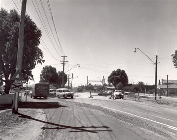 City of Kingston
Photograph - Black and white
... City of Kingston. In 1958 excavations began for the removal of the level crossing gates at the southern end of the Moorabbin shopping centre on Nepean Highway. The station was also lowered below ground. A diversion route was created to enable the flow of traffic ...This photograph depicts the road diversion on Nepean Highway that was implemented to allow construction of the railway line underneath the Nepean Highway at Moorabbin. An "Allourie" Cheese, Honey Canned Ham van is prominent on the left of the image, the railway gates are central and the old Moorabbin Station is visble. Beyond the dates, pedestrians are visible crossing the Nepean Highway. This image is part of a larger collection of images from the Public Transport Corporation displaying train stations and streetscapes in what is now the City of Kingston.In 1958 excavations began for the removal of the level crossing gates at the southern end of the Moorabbin shopping centre on Nepean Highway. The station was also lowered below ground. A diversion route was created to enable the flow of traffic in both directions along the highway.Black and white photograph of road diversion on Nepean Highway, Moorabbin to allow the construction of the railway line below the Nepean Highway at Moorabbin and also to trench the station. This image is part of a larger collection of images from the Public Transport Corporation displaying train stations and streetscapes in what is now the City of Kingston.White adhesive dot sticker: Printed black 199 Handwritten in red ink: 80% Handwritten in black ink on yellow Post-It Note: [indecipherable] 199 - Diversion for Crossing Stamped in blue ink: COPYRIGHT Public Transport Corporation, For reordering photographs, Please quote negative No m 5687, Enquiries C/- PTC Photographic Unit, Telephone switchboard 619 1111railway crossing, railway station, city of moorabbin -
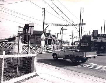 City of Kingston
Photograph - Black and white, c. 1960
... City of Kingston Parkdale Library 96 Parkers Road, Parkdale Parkdale Highett railway station with crossing gates closed and traffic waiting. ...Highett railway station with crossing gates closed and traffic waiting.Black and white photograph of Highett railway gates. Gates are closed and a ute is waiting at the crossing.Stamped on reverse: COPYRIGHT / Public Transport Corporation / For re-ordering photographs / Please quote negative No H3985 / Enquiries C/- PIC Photographic Unit / Telephone switchboard 519 1111highett, city of kingston, level crossing, railway station -
 City of Kingston
Photograph - Black and white, c. 1950
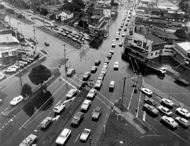
... City of Kingston Parkdale Library 96 Parkers Road, Parkdale Parkdale The image shows a line of traffic travelling along South Road in response to traffic light signlas while an increasing number of cars are banking up along Nepean Highway, also in response to traffic light signals. ...The image shows a line of traffic travelling along South Road in response to traffic light signlas while an increasing number of cars are banking up along Nepean Highway, also in response to traffic light signals.This image provides a strong contrast to images from earlier eras of the same intersection. The amount of traffic has increased enormously as well as commercial development.Black and white photograph with an aerial view of the intersection of Nepean Highway and South Road, taken from above the Moorabbin Council Chambers.Handwritten in black ink Pic [indecipherable] / 1000 Handwritten in red ink: 150%moorabbin, traffic lights, cars, nepean highway -
 City of Kingston
Photograph - Black and white, c. 1950
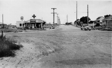
... City of Kingston Parkdale Library 96 Parkers Road, Parkdale Parkdale The intersection of Warrigal Road and Nepean Highway is now a major intersection, serviced by traffic lights. ...The intersection of Warrigal Road and Nepean Highway is now a major intersection, serviced by traffic lights. In the 1950s it was a joining of two sealed roads, although covered in gravel, and with wide gravel shoulders. There are no traffic signs and the few houses visible are not set very far back from the road. This image is one of many in the collections that focuses on either roads or the railway. The development of roads and the railway was crucial to the ongoing development of the area.Black and white photograph of the intersection of Warrigal Road and Nepean Highway, Mentone. Handwritten in blue ink on reverse: 218 Handwritten in red ink on reverse: 75%mentone, roads, suburbs -
 Melbourne Tram Museum
Slide - Set of 6, Keith Caldwell, 1/11/1978 12:00:00 AM
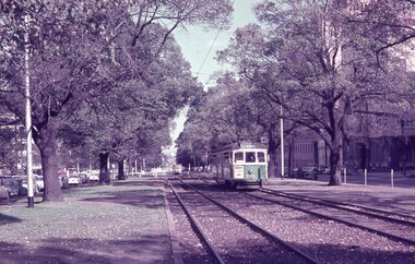
... Dated 13.3.1962. .3 - W7 1003, showing City via Latrobe St route 88, with an Inspector watching and a Policeman on traffic duty. ...Dated 13.3.1962. .3 - W7 1003, showing City via Latrobe St route 88, with an Inspector watching and a Policeman on traffic duty. ...Set of six Agfa Colour slides, cardboard mounts, by Keith Caldwell of trams in Victoria Parade during a disruption with trams for Bourke St turning at Nicholson St. .1 - W6 975 east bound car showing East Preston Bell St and another W2 behind. Has St Vincents Hospital in the background. Dated 16.3.62. .2 - W7 1027 ditto, showing City Brunswick St. Dated 13.3.1962. .3 - W7 1003, showing City via Latrobe St route 88, with an Inspector watching and a Policeman on traffic duty. Dated 17.3.1962. .4 - W7 1017, showing City via Latrobe St, route 90. Dated 17.3.1962 .5 - W5 767, showing South Melbourne and St Kilda Beach, route 10, running in Victoria Parade between Nicholson St and Spring St. Has the ICI building in the background. Dated 17.3.1962. .6 - W6 990 , showing City via Latrobe St, route 90. Dated 17.3.1962Dates as shown above in red ink. .1 and .2 "Victoria Pde" .3 and .6 - BX AS Melb 17.3.62"trams, tramways, victoria parade, reserved track, w7 class, w6 class, route 88, w5 class, tram 975, tram 1027, tram 1003, tram 1017, tram 767, mmtb -
 Melbourne Tram Museum
Photograph - Black & White Photograph/s, Melbourne & Metropolitan Tramways Board (MMTB), late 1970's or early 1980's
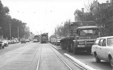
... Shows a number of Z class trams between Gertrude Street and Victoria Parade, congested traffic and concrete bars between tram and road - road segregation. Photo possibly after concrete strips installed. Z Class tram No 30 is running City...Shows a number of Z class trams between Gertrude Street and Victoria Parade, congested traffic and concrete bars between tram and road - road segregation. Photo possibly after concrete strips installed. Z Class tram No 30 is running City ...Black and White Photograph looking north along Nicholson Street Fitzroy, mid to late 1970's or early 1980's. Shows a number of Z class trams between Gertrude Street and Victoria Parade, congested traffic and concrete bars between tram and road - road segregation. Photo possibly after concrete strips installed. Z Class tram No 30 is running City - Spencer St - route 88On the rear of the photograph has in pencil "Presses - jigs - Preston - MMTB"trams, tramways, nicholson st, route 88, traffic control, tram 30, z class, fitzroy -
 Melbourne Tram Museum
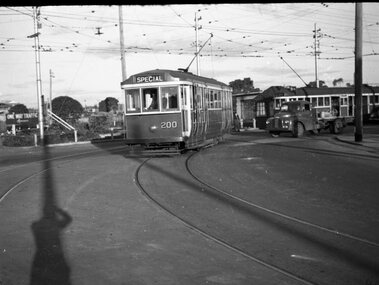
Negative - MMTB Q class Tram 200 - workshop employees special tram, Hugh Ballment, c1954
... In the background is a W2 running a route 9A service to the "City". Note the one-way traffic sign in St Georges Road. ...In the background is a W2 running a route 9A service to the "City". Note the one-way traffic sign in St Georges Road. ...The photograph shows Q class tram No 200 turning from St Georges Road into Miller Street running a special service to West Preston for Preston Workshops employees - see item 8951 for another photo of this tram and the basis of the photograph. In the background is a W2 running a route 9A service to the "City". Note the one-way traffic sign in St Georges Road. Yields information about the of a tram to operate a special service for Preston Workshops workers to West Preston.Negative - 127 film black and white.tramways, preston workshops, tram 200, miller st, trams, st georges road, q class, w2 class, route 9a -
 Melbourne Tram Museum
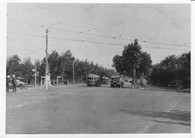
Photograph - W trams and bus at City Road, St Kilda Road intersection, c1926
... City Road. Several W class trams and a tramways Thornycroft "J" bus can be seen. The bus appears to be broken down with the bonnet raised with at least two employees standing beside the vehicle. Two policemen in white helmets stand in the intersection controlling traffic...City Road. Several W class trams and a tramways Thornycroft "J" bus can be seen. The bus appears to be broken down with the bonnet raised with at least two employees standing beside the vehicle. Two policemen in white helmets stand in the intersection controlling traffic ...Photograph looks southward along St Kilda Road from its intersection with City Road and Alexander Avenue, but trees obscure the view towards the Shrine of Remembrance, which may be under construction (1927-34). Tram rails and overhead can be seen turning from St Kilda Road into City Road. Several W class trams and a tramways Thornycroft "J" bus can be seen. The bus appears to be broken down with the bonnet raised with at least two employees standing beside the vehicle. Two policemen in white helmets stand in the intersection controlling traffic.Yields information about early electric trams on St Kilda Road Black and white print with no note.alexander ave, trams, tramways, w class, st kilda road, city road, mmtb buses, thornycroft -
 Ballarat Tramway Museum
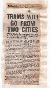
Newspaper, Herald Sun, "Trams will go from two cities", July to Oct 1968
... Also cutting on traffic changes to St Kilda Junction. Date of cutting has been taped onto the sheets. "Trams will go from two cities" Newspaper Herald Sun ...Yields information about the 1968 proposals to close both the Ballarat and Bendigo tramway systems by the state government.Series of newspaper clippings adhered to three quarto lined sheets about the 1968 attempt by the Victorian Government to close the Ballarat and Bendigo tramway systems. .1 - "Trams will go from two cities" - The Sun Friday 19/7/1968, about the Government's decision - gives reasons for the closure. .2 - "Protest over tram protest" - The Sun, 28/8/1968 - with a photo of No. 35 and that the Ballarat Save the Trams Committee not supporting a public protest meeting called by tramway employees. Also has cutting about the State cabinet being delayed by a good train breakdown, a Brisbane train strike and that Country considering the Underground is not vital. .3 - "The Country trams stay" - The Sun Thursday 3/10/1968 - about the Legislative Council not approving the motion to scrap the trams, Labor and Country party combined to defeat the motion. Also cutting on traffic changes to St Kilda Junction. Date of cutting has been taped onto the sheets.closure, ballarat, bendigo, parliament, st kilda junction, sec -
 Ballarat Tramway Museum
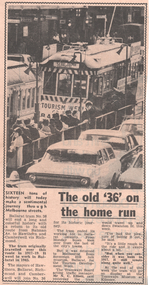
Newspaper, Herald Sun, "The old '36' on the home run", Sep. 1971
... City of Ballarat, during Tourism Week. Notes that it will be running in Swanston St. during the week. Quotes Mr. N.C. Elliott of the MMTB, acting Traffic...City of Ballarat, during Tourism Week. Notes that it will be running in Swanston St. during the week. Quotes Mr. N.C. Elliott of the MMTB, acting Traffic ...Newspaper clipping from The Melbourne Sun, 22/9/1971, about the operation of Ballarat No. 36 promoting the City of Ballarat, during Tourism Week. Notes that it will be running in Swanston St. during the week. Quotes Mr. N.C. Elliott of the MMTB, acting Traffic Manager about the tram. Includes a photo of the tram at a Swanston St. stop. (probably Flinders St.). Notes its running to Hawthorn and the relevant Mayors travelling on the tram. See also Reg. Item 3432.On rear in ink "Sun Wed Sept 22, 1971"melbourne, tourism, mmtb, swanston st, hawthorn -
 Victorian Railway History Library
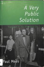
Book, Paul Mees, A very public solution : transport in the dispersed city, 2000
... Urban transportation - Melbourne Local transit - Melbourne Local transit - Ontario In A Very Public Solution, Paul Mees compares Melbourne's public transport system with the highly successful system in Toronto - a 'dispersed' city very like Melbourne with its suburban sprawl - and sheds new light on a century-old debate." "A Very Public Solution is for everyone concerned with urban sustainability and our growing traffic problems. ...In A Very Public Solution, Paul Mees compares Melbourne's public transport system with the highly successful system in Toronto - a 'dispersed' city very like Melbourne with its suburban sprawl - and sheds new light on a century-old debate." "A Very Public Solution is for everyone concerned with urban sustainability and our growing traffic problems.Index, bib, maps, p.331.non-fictionIn A Very Public Solution, Paul Mees compares Melbourne's public transport system with the highly successful system in Toronto - a 'dispersed' city very like Melbourne with its suburban sprawl - and sheds new light on a century-old debate." "A Very Public Solution is for everyone concerned with urban sustainability and our growing traffic problems.urban transportation - melbourne, local transit - melbourne, local transit - ontario