Showing 5046 items matching "crown"
-
 Moorabbin Air Museum
Manual (Item) - King Silver Crown Systems Interconnect Manual 006-5517-00
-
Moorabbin Air Museum
Drawing (Item) - TAA Trans Australia Airlines Viscount Royal Mail and Crown Insignia 526 Sheet 47
-
 Kew Historical Society Inc
Plan - Subdivision Plan, J R Mathers & McMillan, Plan of Subdivision of Part of Crown Portion 83 at Kew : LP6669, 1923-1939
In 1888, in the section of Park Hill Road between Belmont Avenue and Normanby Road there was only one street running between Park Hill Road and Cotham Road. This was Park Road, later to be named Adeney Avenue. Subsequent 20th century subdivisions created the ‘through roads’ of Cecil Street, Wimba Avenue, Florence Avenue, Marshall Avenue, Uvadale Road, and Barrington Avenue. This subdivision represents an attempt by auctioneers, rather than town planners to create an urban environment from larger residential allotments or in many cases farmland. Existing streets such as Parkhill and Normanby Roads provided a convenient starting point for the surveyors, but the Road named ‘Street Street’ indicates the role of the private surveyor in creating streets. Given that a number of allotments are listed as sold on the plan, the street is presumably Cecil Street. Even those lots that had been sold do not quite match the dimensions of the blocks in this parcel of land today, indicating that either further subdivisions or boundary alterations occurred.Subdivision plans are historically important documents used as evidence for the growth of suburbs in Australia. They frequently provide information about when the land was sold as well as evidence relating to surveyors and real estate and financial agents. The numerous subdivision plans in the Kew Historical Society's collection represent working documents, ranging from the initial sketches made in planning a subdivision to printed plans on which auctioneers or agents listed the prices for which individual lots were sold. In a number of cases, the reverse of a subdivision plan in the collection includes a photograph of a house that was also for sale by the agent. These photographs provide significant heritage information relating house design and decoration, fencing and household gardens.The photograph may also be aesthetically significant depending on the importance of the photographic atelier.Hand-drawn subdivision plan of 19 lots facing Parkhill Road, Normanby Road, and an unnamed street [now Cecil Street] in Kew.Estate Agent notes in ink indicate those lots which had sold.subdivision plans - kew, parkhill road - kew, cecil street - kew, normanby road - kew, cecil street -kew, parkhill road - kew, normanby road - kew, crown portion 83 - kew -
 Kew Historical Society Inc
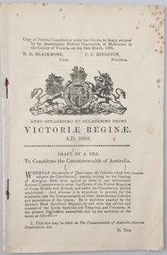
Document, Draft of a Bill to constitute the Commonwealth of Australia : copy of federal constitution under the Crown, as finally adopted by the Australasian Federal Convention at Melbourne, in the colony of Victoria on the 16th March, 1898, 1898
The Australasian Federation Conference met in Melbourne from 6-14 February, 1890. The National Australasian Convention, met in Sydney, from 2 March–9 April 1891. Debates about the draft Australasian Federal Convention of 1897/8 took place over three sessions: First session, Adelaide, 22 March – 5 May 1897 Second session, Sydney, 2-24 September 1897 Third session, Melbourne, 22 January-17 March 1898This volume formed part of the private library of Malcolm Carkeek, former Archivist of the Royal Society of Victoria, and was donated by him to the Kew Historical Society.29 p. : coat of arms ; 21 cm.Adressed to "Mr Edwin McKereth (sic), Farmer, Avoca".australia - constitution, australia - political history - development -
 Kew Historical Society Inc
Plan - Subdivision Plan, Plan of Subdivision of Crown Portion 71, Parish of Boroondara LP12509, Vol.1678, Fol.335526, Before 1930
Prue Sanderson, in her groundbreaking ‘City of Kew Urban Conservation Study : Volume 2 - Development History’ (1988), summarised the periods of urban development and subdivisions of land in Kew. The periods that she identified included 1845-1880, 1880-1893, 1893-1921, 1921-1933, 1933-1943, and Post-War Development. These periods were selected as they represented periods of rapid growth or decline in urban development. An obvious starting point for Sanderson’s groupings involved population growth and the associated economic cycles. These cycles also highlighted urban expansion onto land that was predominantly rural, although in other cases it represented the decline and breakup of large estates. A number of the plans in the Kew Historical Society’s collection can also be found in other collections, such as those of the State Library of Victoria and the Boroondara Library Service. A number are however unique to the collection.Subdivision plans are historically important documents used as evidence of the growth of suburbs in Australia. They frequently provide information about when the land was sold on which a built structure was subsequently constructed as well as evidence relating to surveyors and real estate and financial agents. The numerous subdivision plans in the Kew Historical Society's collection represent working documents, ranging from the initial sketches made in planning a subdivision to printed plans on which auctioneers or agents listed the prices for which individual lots were sold. In a number of cases, the reverse of a subdivision plan in the collection includes a photograph of a house that was also for sale by the agent. These photographs provide significant heritage information relating house design and decoration, fencing and household gardens.The six lots on the south side of Macartney Avenue, between Macartney Avenue and Daniell Place were part of a subdivision that occurred before 1930. The subdivision plan is of interest in that the original name of Daniell Place was Brougham Place. On the Plan, it is noted that lots 5 and 6 (currently 10 and 12 Macartney Avenue) had been sold for £13 each. By November 1930, the new six-roomed villa built on 12 Macartney Avenue was offered for immediate sale at a ‘sacrifice price’. Any offer in reason would be considered, although a £350 deposit was required.subdivision plans - kew, mount street - kew, brougham street - kew , macartney avenue - kew -
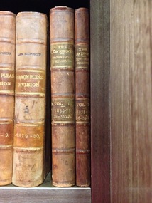 RMIT GSBL Justice Smith Collection
Journal series, Bulwer, J. R, The law reports : cases determined by the Court of Crown Cases reserved, 1872
Previous owners: T. H. Smith, T. W. SmithNo. of volumes: 2 Volume range: Vol. 1 (1865-1872) - Vol. 2 (1872-1875) law reports; digests; etc. -- great britain, criminal law -- great britain -- cases, law reports; digests; etc. -- great britain -- periodicals -
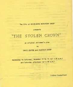 Heidelberg Theatre Company Inc..
Program Photos Newsletter Article, The stolen crown an original children's play by David Ashton and Alastair Sharp directed by David Ashton
1971, 142, panto, youth, directed by david ashton, city of heidelberg repertory group, heidelberg theatre company inc -
Stawell Historical Society Inc
Archive, Crown Cross Extended Quartz Mining Co 1873, July 1873 - August 1875
Debits & Credits Shareholdersstawell, mining -
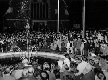 Stawell Historical Society Inc
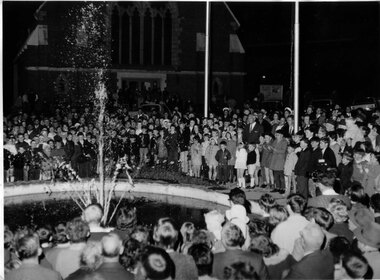
Photograph, Mr John D’Alton Fountain being turned on with the crown watching on 1969
Crowd scene of John D’Alton Fountain being turned on 1969stawell -
 Stawell Historical Society Inc
Photograph, Mr John D’Alton Fountain being turned on with the crown watching on 1969
Crowd scene of John D’Alton Fountain being turned on 1969stawell -
University of Melbourne, Burnley Campus Archives
Map, Plan of Early Melbourne Showing Original Crown Allotments, c. 1852
Copy of 'Map of the City of Melbourne, and its Extension, together with Collingwood, Richmond, Hawthorne, the Emerald Hill, and a portion of Prahran Compiled from the Government Plans and Private Survey by William Green.' (2 copies, one enlarged)melbourne, william green, richmond, hawthorne, collingwood -
 The 5th/6th Battalion Royal Victoria Regiment Historical Collection
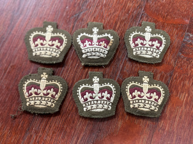
Uniform - Warrant Officer Crown, Warrant Officer Crown with green thread
British Army Household Bridge WO Warrant Officer SD Rank x 6 -
Thompson's Foundry Band Inc. (Castlemaine)
Sheet Music, Britiania'S Crown Of Song
-
Thompson's Foundry Band Inc. (Castlemaine)
Sheet Music, Crown Of Honour
-
 The Celtic Club
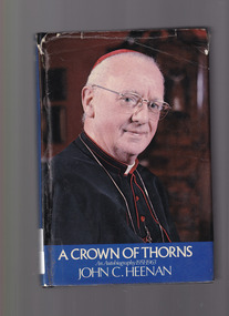
Book, John C. Heenan, A crown of thorns: An autobiography 1951-1963, 1974
An autobiography covering John Heenan's years as Bishop of Leeds and Archbishop of Liverpool, concluding with his return to his native diocese of Westminster as Archbishop in September 1963.Index, plates, ill., p.399.non-fictionAn autobiography covering John Heenan's years as Bishop of Leeds and Archbishop of Liverpool, concluding with his return to his native diocese of Westminster as Archbishop in September 1963.cardinals - england - biography, catholic priests - biography -
Victorian Harness Racing Heritage Collection at Lord's Raceway Bendigo
Document - Record, Harness Horse, Grand Crown
Stephen Spark compiled horses performance records starting in 1983 on his typewriter. Grand Grown raced from 1974 (3yo) through to 1979 (8yo). Career: 21 wins 10 seconds 12 thirds 105 starts.Typed document in black and red ink.harness racing, australasian harness racing, horse career, performance records, bendigo harness racing club, bhrc, grand crown, j cascun, joe cascun -
 Mrs Aeneas Gunn Memorial Library
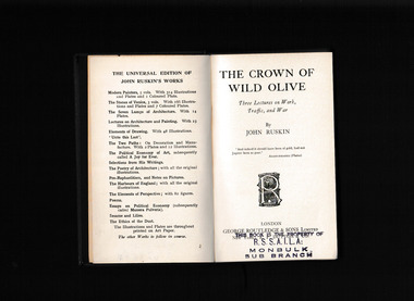
Book, George Routledge and Sons, The crown of wild olive : three lectures on industry & war
This 1866 collection of essays on "Work," "Traffic," and "War," begins with a preface condemning the human depletion of nature for what Ruskin saw as valueless gains. In this way, mining the ground for metals, water, and other resources parallels the work of the three lecture topics--all is done for the money. But what Ruskin wants to know is what the ultimate effect and product of their work is?Index, notes, p.132.non-fictionThis 1866 collection of essays on "Work," "Traffic," and "War," begins with a preface condemning the human depletion of nature for what Ruskin saw as valueless gains. In this way, mining the ground for metals, water, and other resources parallels the work of the three lecture topics--all is done for the money. But what Ruskin wants to know is what the ultimate effect and product of their work is? john ruskin 1819-1900, ethics -
![Map, Plan of Subdivision of Crown Portion 23 & parts 24-25, Parish of Korkuperrimul [1900s?]](/media/collectors/5e461d8021ea67224c82f2a1/items/675fe058304668462205d4fb/item-media/675fe0ef304668462205d7d6/item-fit-380x285.jpg) Bacchus Marsh & District Historical Society
Bacchus Marsh & District Historical SocietyMap, Plan of Subdivision of Crown Portion 23 & parts 24-25, Parish of Korkuperrimul [1900s?]
The Parish of Korkuperrimul includes a significant section of the township of Bacchus Marsh and extends in western and northern directions from the township area. The date of the subdivision indicated on this plan has not been established. The engineer's stamp on the drawing shows the firm of Muntz and Muntz who were operating under that name in the early part of the 20th century.A single page paper map showing 20 blocks of land for sale in the Parish of Korkuperrimul. Scale 100 feet to 1 inch. The map is pasted into a bound volume containing 76 maps or plans in total. High resolution digital image stored on BMDHS computer network. Stamped: 'Muntz & Muntz Civil Engineers, Architects & Surveyors, Trustees Chambers ?? Cor Collins Street and Bank Placeland sales bacchus marsh, bacchus marsh victoria maps, land sales korkuperrimul parish -
 Ringwood and District Historical Society
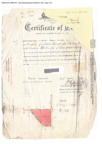
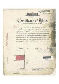
Document, Certificate of Title - Edward Thomas Miles, Gentleman, "Woorara", Ringwood - part of Crown Section 20, Parish of Warrandyte, County of Evelyn - 1913
A4 copies of damaged Landata Victoria Historical Search documents - Vol 3726 Fol 200 - incomplete proprietor and transfer details.Edward Thomas Miles is now the proprietor of an Estate in Fee-simple subject to the Encumbrances notified hereunder ... 27 acres 19 perches or thereabouts, together with a right of carriage way over roads coloured brown. Subdivision map includes un-named roads - western side is Wonga Road (later Warranwood Road), and eastern side is Grandview Grove (later Bemboka Road), both north of Plymouth Road, Ringwood, Vic. Transfers include (illegible) Dobbs, November, 1927 - 5 acres Harry Temple Marshall, 1st December, 1928 - 10ac 3r David Edward Meyland, 4th October, 194-? (illegible). -
 Ringwood and District Historical Society
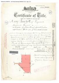
Document, Certificate of Title - Mary Burchett, Lilydale Road, Ringwood - part of Crown Section 20, Parish of Warrandyte, County of Evelyn - 5th July, 1911
A4 copies of Landata Victoria Historical Search documents - Vol 3520 Fol 703990.Mary Burchett of Ringwood, Married Woman, is now the proprietor of an Estate in Fee-simple subject to the Encumbrances notified hereunder ... 50 acres 1 rood 32 perches or thereabouts, being lots 1 and 10 on plan of subdivision no.4315. Subdivision map includes un-named roads - western side is Wonga Road (later Warranwood Road), and eastern side is Grandview Grove (later Bemboka Road), both north of Plymouth Road, Ringwood, Vic. Title transferred to Theodore Hartley Burchett, 27th July, 1911. Encumbrance comment "Special railway condition contained in Grant to Francis Cooke." -
 Buninyong Visitor Information Centre
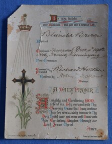
Ceremonial object - Certificate, Diocesan Book Society, Melbourne, 'Be thou faithful unto death and I will give thee a crown of life', c.1900
In 1902 Blanche Brown was confirmed into the Anglican Church at Buninyong, being presented with this card, signed by the Bishop of Ballarat Arthur Green and Richard Hosken. Colour printed card with religious symbols and a prayer. Handwritten names of the confirmed person and those authorising the confirmation of Blanche Brown into the Anglican Church. religion, christianity, buninyong, church of england -
 Ringwood and District Historical Society
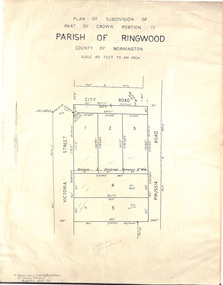
Document - Folder, Plan of Subdivision - Part of Crown Portion 11, Parish of Ringwood - undated, circa 1950s
Buff coloured survey map of subdivision glued to manilla folder. Five residential blocks bounded by City Road, Victoria Street (later Ireland Street), and Prussia Road (later Regina Street).(Surveyor) R. James Love L.S. M.I.S. (Aust) M.A.I.C. 52 Comer Street Brighton East S6 Phone XB-5928 -
Victorian Harness Racing Heritage Collection at Lord's Raceway Bendigo
Document - Record, Harness Horse, Crown Law
Stephen Spark compiled horses performance records starting in 1983 on his typewriter. Crown Law raced from 1953 (2yo) through to 1962 (11yo). Career: 24 wins 31 seconds 15 thirds 157 starts. Typed document in black and red ink.harness racing, australasian harness racing, horse career, performance records, bendigo harness racing club, bhrc, crown law, j barron jnr, a jamieson -
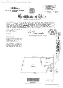 Ringwood and District Historical Society
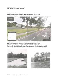
Document - Certificate of Title and Maroondah Heritage Study, "Elouera", 59 Bemboka Road, Warranwood, Victoria, previously part of Crown Section 20, Parish of Warrandyte, County of Evelyn - 4th February, 1987
Property subsequently subdivided into residential allotments with formation of Aspen Court, Warranwood, circa 2010.A4 copies of Landata Victoria documents - Vol 9725 Fol 210 derived from Vol 9701 Vol 469, and 2-page Heritage Study report.Ian Vance Lloyd and June Josephine Lloyd are joint proprietors of an estate in fee simple - Lot 4 on Plan of Subdivision no.204137B shown on the map. Subdivision includes Bemboka Road. Encumbrance E-1 later extended through Lot 4 as Aspen Court. Transfer - Proprietor June Josephine Lloyd - 29 July, 1993. Documents include 2-page Heritage report for study conducted prior to subsequent Aspen Court residential development circa 2010. -
Bendigo Symphony Orchestra Inc.
Work on paper - Sheet Music, Auber, Daniel, Crown Diamonds Overture
Sheet Music for the Crown Diamonds Overture (Les diamants de la couronne) by Daniel Auber. Published by Boosey and HawkesParts printed on paper, for Symphony OrchestrafictionSheet Music for the Crown Diamonds Overture (Les diamants de la couronne) by Daniel Auber. Published by Boosey and Hawkescrown diamonds overture, les diamants de la couronne, daniel auber -
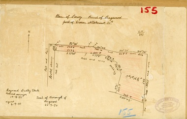 Ringwood and District Historical Society
Map, Plan of Survey, Parish of Ringwood - Part of Crown Allotment 31A - 1950
Hand drawn and labelled copy of map with survey measurements of allotment on Isobel Avenue (Isabel Avenue?), Ringwood East. Raymond Dudley Steele Licensed Surveyor 10-8-50, signed 6-9-50, Seal of Borough of Ringwood 26-9-50. Rubber stamp - Dugdale, Simmons & Stevens, Solicitors, Peacock House, 486 Bourke Street Melbourne. Typewritten heading on backing paper - Capt. M.H. Moyes - Correspondence Supplementary to Statements. -
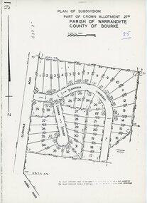 Ringwood and District Historical Society
Map - Plan of Subdivision, Part of Crown Allotment 27B Parish of Warrandyte County of Bourke (undated, circa 1970)
Photocopied subdivision map of 38 residential allotments in Glenvale Road, Cantala Crescent, and Giana Court, north of Kubba Road, Ringwood. -
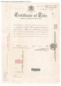 Ringwood and District Historical Society
Document, Certificate of Title - W.G. Carter, Grandview Grove, Warranwood, Victoria, (later Bemboka Road) - part of Crown Section Twenty, Parish of Warrandyte, County of Evelyn - 1947
A4 copies of Landata Victoria Historical Search documents - Vol 7052 Fol 1410222. Includes Carter Family Tree property notes. William George Carter of Grandview Grove Ringwood, Nurseryman, is now the proprietor - three acres or thereabouts shown on map (12202a) - 14th March, 1947. Transfer B284834 Registered 21 September, 1961 - 1 acre shown on map (12202c) north of Plymouth Road. NOTES ON GRANDVIEW GROVE PROPERTY (Carter Family Tree extract) The Grandview Grove property was purchased by William (Bill) and Doreen Carter in 1947 as three acres of uncleared bushland. They had a 2 bedroom fibro-cement house built on the land which they informally called "Willoreen". With Doreen looking after sons Peter (born in 1940) and Robin (born in 1950), Bill worked locally at Croydon Dairy. The family spent much of their spare time clearing the land, where Bill then grew and sold fruit, flowers and berries, particularly strawberries, as a hobby and to supplement their income. Bill continued to do so while Peter and Robin were growing up, and after Doreen died in 1958. In 1961 Bill sold one of the three acres to one of his seven sisters, Grace, who lived in Kew but later moved to Rosebud and sold the land without ever building on it. During the 1960s, Grandview Grove was renamed Bemboka Road. After retiring as a milkman, Bill moved to Rosebud, Vic, and in 1977, sold the property to the Anglican Church, who were looking to invest in the site in anticipation of proposed future residential development in the area. As nearby properties were subdivided during the 1980s, the house, which the Church had initially utilised as low-cost family accommodation, was modified internaly to become a church/Sunday school. By the early 2000s, construction of a contemporary-design church and carparking area between the house and street alignment had been completed but the house remained as a detatched meeting room until falling into disrepair and was eventually demolished around 2010. -
 Ringwood and District Historical Society
Archive - Parent Record, Family History - Collection of 1960s Land Titles and Property Records associated with Carter and Brown Families and others, Grandview Grove, (later Bemboka Road) Warranwood, (Parts of Crown Grant 20, 1854)
Set of four clear-fronted plastic A4 binders containing family history research printouts and photocopies. -
 Ringwood and District Historical Society
Document, Certificate of Title - Thomas Arthur Wentworth Burkitt - part of Crown Section 20, Parish of Warrandyte, County of Evelyn - 1st April, 1919
A4 copies of Landata Victoria Historical Search documents - Vol 4197 Fol 839286.Winifred Cambridge of Balwyn, Married Woman, is now the proprietor of an Estate in Fee-simple subject to the Encumbrances notified hereunder ... 17 acres 2 roods 3 perches or thereabouts, being part of Lot 9 on plan of subdivision no.4315, Bemboka Road, Warranwood, Victoria. Encumbrance comment "Appurtenant to carriageway over Omeo Parade on LP12040". Transfers include John Collins of Brysons Road Ringwood, Farmer - 16th June, 1944, Kevin Collins of Warranwood, Carrier - 20th September, 1951, Francis Mohan of St.Kilda - 19th January, 1968, Vivian Campbell Rush, Engineer, and Dorothy May Rush, Married Woman, both of Main Road, Warrandyte, joint proprietors, and Alan Humphrey Croxford, Gentleman, and Eleanor Pearl Croxford, Married Woman, both of Pound Road, Warrandyte, joint proprietors as Tenants In Common - 31st March, 1969, Transferred as to the interest of Alan Humphrey Croxford and Eleanor Pearl Croxford - 13th July, 1973. (See Alan Humphrey Croxford biography link https://adb.anu.edu.au/biography/croxford-alan-humphrey-12375)