Showing 511 items
matching first decade
-
 National Wool Museum
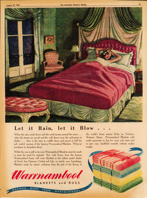
Archive - Advertisement, The Warrnambool Woollen Mill, 1945
Note from collector- "For more than 100 years blankets were made all over Australia in over 100 woollen mills. My aim, is to preserve 100 examples of these wonderful pieces of history. Ten years ago I started collecting the iconic Onkaparinga travel rugs, so that on movie nights at home there would be plenty to go around. Everyone had their favourite; even the cat had his own – a small red tartan one. Keeping an eye out for those travel rugs at op-shops and markets, collectable stores and bazaars, led to noticing vintage blankets. I'd never really thought about them before or paid much attention though of course I had grown up with them at my grandmother's. When I discovered my first Laconia cream blanket with blue stripes, my eyes just went gaga. Well that was it, I was hooked and since then over 500 blankets have passed through my hands. These common, everyday items, found in all households for so many decades, were traditional engagement gifts. Pairs were prized wedding presents turning into family heirlooms. They were fashionable dressers of beds, givers of warmth, bestowers of security and reliability. The comfort found in these objects resonates with almost all of us; we grew up with them ourselves or fondly recall them in a grandparent’s home. There is no modern replacement with the integrity of these old blankets, many of them now older than most of us. They are romantic, sensible, special, familiar, nostalgic and nothing else feels so appropriate in so many situations. No offense to the great Aussie doona, but from hippie to hipster, at a music festival, picnic, campsite or couch, a vintage blanket is something coveted by all. This industry that employed tens of thousands and must have been such a huge contributor to the economy is almost completely lost now. Blanket Fever is an ode to everything that came before: the land, the sheep, the shearers, the hands, the mills, the weavers, the designers, the distributors, the department stores. To the grandparents that gave them, the people that received them, the families that kept them; thank you. I’m passionate about my collection of Australian blankets manufactured in mostly Victoria, South Australia and Tasmania from the 1930s to the end of the 1960s. The collection has blankets from each of these four decades representing the styles and fashions of their time and includes dated advertisements which help determine the eras the blankets are from." Let it rain, let it blow... (lady in bed)Let it Rain, Let it Blow…/Warrnambool Blankets and Rugs/Warmer Wool from Warrnambool blanket, blanket fever, wool, warrnambool, advertisement, australian women's weekly -
 National Wool Museum
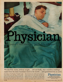
Archive - Advertisement, Collins Bros Mill Pty Ltd, 1959
Collector's note: "For more than 100 years blankets were made all over Australia in over 100 woollen mills. My aim, is to preserve 100 examples of these wonderful pieces of history. Ten years ago I started collecting the iconic Onkaparinga travel rugs, so that on movie nights at home there would be plenty to go around. Everyone had their favourite; even the cat had his own – a small red tartan one. Keeping an eye out for those travel rugs at op-shops and markets, collectable stores and bazaars, led to noticing vintage blankets. I'd never really thought about them before or paid much attention though of course I had grown up with them at my grandmother's. When I discovered my first Laconia cream blanket with blue stripes, my eyes just went gaga. Well that was it, I was hooked and since then over 500 blankets have passed through my hands. These common, everyday items, found in all households for so many decades, were traditional engagement gifts. Pairs were prized wedding presents turning into family heirlooms. They were fashionable dressers of beds, givers of warmth, bestowers of security and reliability. The comfort found in these objects resonates with almost all of us; we grew up with them ourselves or fondly recall them in a grandparent’s home. There is no modern replacement with the integrity of these old blankets, many of them now older than most of us. They are romantic, sensible, special, familiar, nostalgic and nothing else feels so appropriate in so many situations. No offense to the great Aussie doona, but from hippie to hipster, at a music festival, picnic, campsite or couch, a vintage blanket is something coveted by all. This industry that employed tens of thousands and must have been such a huge contributor to the economy is almost completely lost now. Blanket Fever is an ode to everything that came before: the land, the sheep, the shearers, the hands, the mills, the weavers, the designers, the distributors, the department stores. To the grandparents that gave them, the people that received them, the families that kept them; thank you. I’m passionate about my collection of Australian blankets manufactured in mostly Victoria, South Australia and Tasmania from the 1930s to the end of the 1960s. The collection has blankets from each of these four decades representing the styles and fashions of their time and includes dated advertisements which help determine the eras the blankets are from. Physician - years-of-bliss blankets (man asleep in bed) Physician - years-of-bliss blankets - just feel the difference!/Wonderfully warm, without weight…soft and fluffy after countless washings…made from the most luxurious wool in the world….and guaranteed for 20 years/Physician/Luxurious Woollen Blanketsblanket, blanket fever, wool, collins bros mills, physician, advertisement, australian women's weekly, geelong -
 National Wool Museum
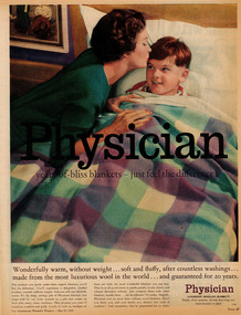
Archive - Advertisement, Collins Bros Mill Pty Ltd, 1959
Collector's note: "For more than 100 years blankets were made all over Australia in over 100 woollen mills. My aim, is to preserve 100 examples of these wonderful pieces of history. Ten years ago I started collecting the iconic Onkaparinga travel rugs, so that on movie nights at home there would be plenty to go around. Everyone had their favourite; even the cat had his own – a small red tartan one. Keeping an eye out for those travel rugs at op-shops and markets, collectable stores and bazaars, led to noticing vintage blankets. I'd never really thought about them before or paid much attention though of course I had grown up with them at my grandmother's. When I discovered my first Laconia cream blanket with blue stripes, my eyes just went gaga. Well that was it, I was hooked and since then over 500 blankets have passed through my hands. These common, everyday items, found in all households for so many decades, were traditional engagement gifts. Pairs were prized wedding presents turning into family heirlooms. They were fashionable dressers of beds, givers of warmth, bestowers of security and reliability. The comfort found in these objects resonates with almost all of us; we grew up with them ourselves or fondly recall them in a grandparent’s home. There is no modern replacement with the integrity of these old blankets, many of them now older than most of us. They are romantic, sensible, special, familiar, nostalgic and nothing else feels so appropriate in so many situations. No offense to the great Aussie doona, but from hippie to hipster, at a music festival, picnic, campsite or couch, a vintage blanket is something coveted by all. This industry that employed tens of thousands and must have been such a huge contributor to the economy is almost completely lost now. Blanket Fever is an ode to everything that came before: the land, the sheep, the shearers, the hands, the mills, the weavers, the designers, the distributors, the department stores. To the grandparents that gave them, the people that received them, the families that kept them; thank you. I’m passionate about my collection of Australian blankets manufactured in mostly Victoria, South Australia and Tasmania from the 1930s to the end of the 1960s. The collection has blankets from each of these four decades representing the styles and fashions of their time and includes dated advertisements which help determine the eras the blankets are from. Physician - years-of-bliss blankets -(mother and child)Physician - years-of-bliss blankets - just feel the difference!/Wonderfully warm, without weight…soft and fluffy after countless washings…made from the most luxurious wool in the world….and guaranteed for 20 years/Physician/Luxurious Woollen Blanketsblanket, blanket fever, wool, collins bros, physician, geelong, advertisement, australian women's weekly -
 National Wool Museum
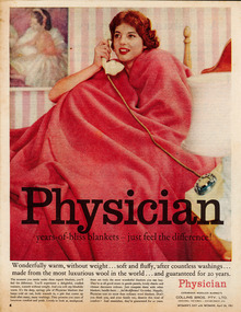
Archive - Advertisement, Collins Bros Mill Pty Ltd, 1961
Collector's note: "For more than 100 years blankets were made all over Australia in over 100 woollen mills. My aim, is to preserve 100 examples of these wonderful pieces of history. Ten years ago I started collecting the iconic Onkaparinga travel rugs, so that on movie nights at home there would be plenty to go around. Everyone had their favourite; even the cat had his own – a small red tartan one. Keeping an eye out for those travel rugs at op-shops and markets, collectable stores and bazaars, led to noticing vintage blankets. I'd never really thought about them before or paid much attention though of course I had grown up with them at my grandmother's. When I discovered my first Laconia cream blanket with blue stripes, my eyes just went gaga. Well that was it, I was hooked and since then over 500 blankets have passed through my hands. These common, everyday items, found in all households for so many decades, were traditional engagement gifts. Pairs were prized wedding presents turning into family heirlooms. They were fashionable dressers of beds, givers of warmth, bestowers of security and reliability. The comfort found in these objects resonates with almost all of us; we grew up with them ourselves or fondly recall them in a grandparent’s home. There is no modern replacement with the integrity of these old blankets, many of them now older than most of us. They are romantic, sensible, special, familiar, nostalgic and nothing else feels so appropriate in so many situations. No offense to the great Aussie doona, but from hippie to hipster, at a music festival, picnic, campsite or couch, a vintage blanket is something coveted by all. This industry that employed tens of thousands and must have been such a huge contributor to the economy is almost completely lost now. Blanket Fever is an ode to everything that came before: the land, the sheep, the shearers, the hands, the mills, the weavers, the designers, the distributors, the department stores. To the grandparents that gave them, the people that received them, the families that kept them; thank you. I’m passionate about my collection of Australian blankets manufactured in mostly Victoria, South Australia and Tasmania from the 1930s to the end of the 1960s. The collection has blankets from each of these four decades representing the styles and fashions of their time and includes dated advertisements which help determine the eras the blankets are from. Physician - years-of-bliss blankets - (woman on telephone in bed under red blanket)Physician - years-of-bliss blankets - just feel the difference!/Wonderfully warm, without weight…soft and fluffy after countless washings…made from the most luxurious wool in the world….and guaranteed for 20 years/Physician/Luxurious Woollen Blanketsblanket, blanket fever, wool, physician, collins bros, geelong, advertisement, australian women's weekly -
 National Wool Museum
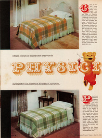
Archive - Advertisement, Collins Bros Mill Pty Ltd, 1964
Collector's note: "For more than 100 years blankets were made all over Australia in over 100 woollen mills. My aim, is to preserve 100 examples of these wonderful pieces of history. Ten years ago I started collecting the iconic Onkaparinga travel rugs, so that on movie nights at home there would be plenty to go around. Everyone had their favourite; even the cat had his own – a small red tartan one. Keeping an eye out for those travel rugs at op-shops and markets, collectable stores and bazaars, led to noticing vintage blankets. I'd never really thought about them before or paid much attention though of course I had grown up with them at my grandmother's. When I discovered my first Laconia cream blanket with blue stripes, my eyes just went gaga. Well that was it, I was hooked and since then over 500 blankets have passed through my hands. These common, everyday items, found in all households for so many decades, were traditional engagement gifts. Pairs were prized wedding presents turning into family heirlooms. They were fashionable dressers of beds, givers of warmth, bestowers of security and reliability. The comfort found in these objects resonates with almost all of us; we grew up with them ourselves or fondly recall them in a grandparent’s home. There is no modern replacement with the integrity of these old blankets, many of them now older than most of us. They are romantic, sensible, special, familiar, nostalgic and nothing else feels so appropriate in so many situations. No offense to the great Aussie doona, but from hippie to hipster, at a music festival, picnic, campsite or couch, a vintage blanket is something coveted by all. This industry that employed tens of thousands and must have been such a huge contributor to the economy is almost completely lost now. Blanket Fever is an ode to everything that came before: the land, the sheep, the shearers, the hands, the mills, the weavers, the designers, the distributors, the department stores. To the grandparents that gave them, the people that received them, the families that kept them; thank you. I’m passionate about my collection of Australian blankets manufactured in mostly Victoria, South Australia and Tasmania from the 1930s to the end of the 1960s. The collection has blankets from each of these four decades representing the styles and fashions of their time and includes dated advertisements which help determine the eras the blankets are from. Physician - the most beautiful blankets (double page)Vibrant colours or muted tones are yours in/Physician/pure lambswool, chillproof, mothproof, odourlessblanket, blanket fever, wool, collins bros mills, physician, geelong, advertisement, australian women's weekly -
 National Wool Museum
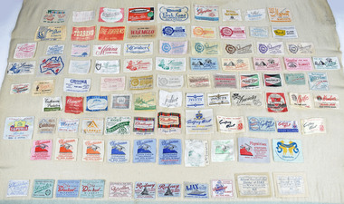
Textile - label sampler, 1930-1970s
Collector's note: "For more than 100 years blankets were made all over Australia in over 100 woollen mills. My aim, is to preserve 100 examples of these wonderful pieces of history. Ten years ago I started collecting the iconic Onkaparinga travel rugs, so that on movie nights at home there would be plenty to go around. Everyone had their favourite; even the cat had his own – a small red tartan one. Keeping an eye out for those travel rugs at op-shops and markets, collectable stores and bazaars, led to noticing vintage blankets. I'd never really thought about them before or paid much attention though of course I had grown up with them at my grandmother's. When I discovered my first Laconia cream blanket with blue stripes, my eyes just went gaga. Well that was it, I was hooked and since then over 500 blankets have passed through my hands. These common, everyday items, found in all households for so many decades, were traditional engagement gifts. Pairs were prized wedding presents turning into family heirlooms. They were fashionable dressers of beds, givers of warmth, bestowers of security and reliability. The comfort found in these objects resonates with almost all of us; we grew up with them ourselves or fondly recall them in a grandparent’s home. There is no modern replacement with the integrity of these old blankets, many of them now older than most of us. They are romantic, sensible, special, familiar, nostalgic and nothing else feels so appropriate in so many situations. No offense to the great Aussie doona, but from hippie to hipster, at a music festival, picnic, campsite or couch, a vintage blanket is something coveted by all. This industry that employed tens of thousands and must have been such a huge contributor to the economy is almost completely lost now. Blanket Fever is an ode to everything that came before: the land, the sheep, the shearers, the hands, the mills, the weavers, the designers, the distributors, the department stores. To the grandparents that gave them, the people that received them, the families that kept them; thank you. I’m passionate about my collection of Australian blankets manufactured in mostly Victoria, South Australia and Tasmania from the 1930s to the end of the 1960s. The collection has blankets from each of these four decades representing the styles and fashions of their time and includes dated advertisements which help determine the eras the blankets are from. One hundred mill labels sewn onto a single sized cream blanket with blue end panels(On original blanket label) "Marco" Blanket/Wool 70%/Cotton 30%/Guaranteed Free From Fillingwool, blanket, blanket fever, labels, sampler -
 National Wool Museum
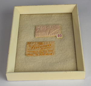
Textile - Blanket labels
Collector's note: "For more than 100 years blankets were made all over Australia in over 100 woollen mills. My aim, is to preserve 100 examples of these wonderful pieces of history. Ten years ago I started collecting the iconic Onkaparinga travel rugs, so that on movie nights at home there would be plenty to go around. Everyone had their favourite; even the cat had his own – a small red tartan one. Keeping an eye out for those travel rugs at op-shops and markets, collectable stores and bazaars, led to noticing vintage blankets. I'd never really thought about them before or paid much attention though of course I had grown up with them at my grandmother's. When I discovered my first Laconia cream blanket with blue stripes, my eyes just went gaga. Well that was it, I was hooked and since then over 500 blankets have passed through my hands. These common, everyday items, found in all households for so many decades, were traditional engagement gifts. Pairs were prized wedding presents turning into family heirlooms. They were fashionable dressers of beds, givers of warmth, bestowers of security and reliability. The comfort found in these objects resonates with almost all of us; we grew up with them ourselves or fondly recall them in a grandparent’s home. There is no modern replacement with the integrity of these old blankets, many of them now older than most of us. They are romantic, sensible, special, familiar, nostalgic and nothing else feels so appropriate in so many situations. No offense to the great Aussie doona, but from hippie to hipster, at a music festival, picnic, campsite or couch, a vintage blanket is something coveted by all. This industry that employed tens of thousands and must have been such a huge contributor to the economy is almost completely lost now. Blanket Fever is an ode to everything that came before: the land, the sheep, the shearers, the hands, the mills, the weavers, the designers, the distributors, the department stores. To the grandparents that gave them, the people that received them, the families that kept them; thank you. I’m passionate about my collection of Australian blankets manufactured in mostly Victoria, South Australia and Tasmania from the 1930s to the end of the 1960s. The collection has blankets from each of these four decades representing the styles and fashions of their time and includes dated advertisements which help determine the eras the blankets are from. Two blanket labels, framed, on blanket backing Castlemaine Pure Wool/The Laconia Blanket/Guaranteed All Pure Wool And Odorless/Made in Australiawool, blanket, blanket fever, sampler, labels -
 National Wool Museum
Book - Onkaparinga, Onkaparinga Woollen Mill Company, 1992
Collector's note: "For more than 100 years blankets were made all over Australia in over 100 woollen mills. My aim, is to preserve 100 examples of these wonderful pieces of history. Ten years ago I started collecting the iconic Onkaparinga travel rugs, so that on movie nights at home there would be plenty to go around. Everyone had their favourite; even the cat had his own – a small red tartan one. Keeping an eye out for those travel rugs at op-shops and markets, collectable stores and bazaars, led to noticing vintage blankets. I'd never really thought about them before or paid much attention though of course I had grown up with them at my grandmother's. When I discovered my first Laconia cream blanket with blue stripes, my eyes just went gaga. Well that was it, I was hooked and since then over 500 blankets have passed through my hands. These common, everyday items, found in all households for so many decades, were traditional engagement gifts. Pairs were prized wedding presents turning into family heirlooms. They were fashionable dressers of beds, givers of warmth, bestowers of security and reliability. The comfort found in these objects resonates with almost all of us; we grew up with them ourselves or fondly recall them in a grandparent’s home. There is no modern replacement with the integrity of these old blankets, many of them now older than most of us. They are romantic, sensible, special, familiar, nostalgic and nothing else feels so appropriate in so many situations. No offense to the great Aussie doona, but from hippie to hipster, at a music festival, picnic, campsite or couch, a vintage blanket is something coveted by all. This industry that employed tens of thousands and must have been such a huge contributor to the economy is almost completely lost now. Blanket Fever is an ode to everything that came before: the land, the sheep, the shearers, the hands, the mills, the weavers, the designers, the distributors, the department stores. To the grandparents that gave them, the people that received them, the families that kept them; thank you. I’m passionate about my collection of Australian blankets manufactured in mostly Victoria, South Australia and Tasmania from the 1930s to the end of the 1960s. The collection has blankets from each of these four decades representing the styles and fashions of their time and includes dated advertisements which help determine the eras the blankets are from. Paperback book, white with title - 'Onkaparinga' in red writing on front coverOnkaparinga - The Story of a Mill/Carol Brockhoffblanket, blanket fever, onkaparinga, woollen mill, lobethal -
Koorie Heritage Trust
Book, Berzins, Baiba, The coming of the strangers : life in Australia 1788-1822, 1988
Contents: The coming of The Strangers; The environment & its shapers; The Governors & Their Circle; Staying & leaving ; The Lot of Women; Australia & the World; Australia in 1822. Blurb: The Coming of The Strangers challenges our ideas about the European settlement of Australia. Through a selection of the many document, painting and engravings held in the Mitchell and Dixon collections of the State Library of New South Wales, a picture of life in Australia is reconstructed - spanning the arrival of the First Fleet in 1788 to 1822 when the first generation of white Australians had accepted the continent as their home. Those who left no written records: the Aboriginal people; white women and convicts, have been brought to the foreground to give a balanced perspective of history during the earliest decades of European habitation in Australia. The Coming of The Strangers accompanies a major exhibition being held at the State Library of New South Wales during 1988. In co-ordinating both this book and the exhibition, the Mitchell Librarian, Baiba Berzins brings to public view many letters, journals and works of art that have not been published or displayed for over a century.144 p. : ill. (some col.), facsims., ports. ; 27 cm.Contents: The coming of The Strangers; The environment & its shapers; The Governors & Their Circle; Staying & leaving ; The Lot of Women; Australia & the World; Australia in 1822. Blurb: The Coming of The Strangers challenges our ideas about the European settlement of Australia. Through a selection of the many document, painting and engravings held in the Mitchell and Dixon collections of the State Library of New South Wales, a picture of life in Australia is reconstructed - spanning the arrival of the First Fleet in 1788 to 1822 when the first generation of white Australians had accepted the continent as their home. Those who left no written records: the Aboriginal people; white women and convicts, have been brought to the foreground to give a balanced perspective of history during the earliest decades of European habitation in Australia. The Coming of The Strangers accompanies a major exhibition being held at the State Library of New South Wales during 1988. In co-ordinating both this book and the exhibition, the Mitchell Librarian, Baiba Berzins brings to public view many letters, journals and works of art that have not been published or displayed for over a century.australia -- history -- 1788-1851 -
Koorie Heritage Trust
Book, Boys, Robert Douglass, First years at Port Phillip : preceded by a summary of historical events from 1768, 1935
... and pamphlets dealing with the first decade of this State. 159 p., [4 ...Foreword: This Chronology extends from the first permanent settlement of "Port Phillip" or "Australia Felix," at Portland Bay, by Edward Henty, until the beginning of the proceedings of the first Town Council of Melbourne. In order to provide the necessary historical perspective, the Chronology has been preceded by a Summary of Historical Events. Many matters are here noted for the first time, and, through the courtesy of the Trustees of the Public Library of Victoria, the compiler was allowed to publish in full the diary kept by Sir Richard Bourke during his visit to Port Phillip in March, 1837. In addition to the authorities quoted in the text, recourse has been had to the large collection of official documents in the Public Library of Victoria (including the collection of La Trobe papers), the Historical Records of Australia, and the books and pamphlets dealing with the first decade of this State.159 p., [4] leaves of plates : ill. ; index; 22 cm.Foreword: This Chronology extends from the first permanent settlement of "Port Phillip" or "Australia Felix," at Portland Bay, by Edward Henty, until the beginning of the proceedings of the first Town Council of Melbourne. In order to provide the necessary historical perspective, the Chronology has been preceded by a Summary of Historical Events. Many matters are here noted for the first time, and, through the courtesy of the Trustees of the Public Library of Victoria, the compiler was allowed to publish in full the diary kept by Sir Richard Bourke during his visit to Port Phillip in March, 1837. In addition to the authorities quoted in the text, recourse has been had to the large collection of official documents in the Public Library of Victoria (including the collection of La Trobe papers), the Historical Records of Australia, and the books and pamphlets dealing with the first decade of this State.victoria -- history -- 1834-1851. | victoria -- history -- to 1834. -
Whitehorse Historical Society Inc.
Article, Fashion has kept pace, 16/04/2008 12:00:00 AM
Whitehorse Historical Society's exhibition 'Four decades of women's fashions of the 20th century', first half entitled 'From pantaloons to G-strings' is on display at the Schwerkolt Cottage & Museum Complex.Whitehorse Historical Society's exhibition 'Four decades of women's fashions of the 20th century', first half entitled 'From pantaloons to G-strings' is on display at the Schwerkolt Cottage & Museum Complex. Photo of Vicki Jones-Evans and exhibitsWhitehorse Historical Society's exhibition 'Four decades of women's fashions of the 20th century', first half entitled 'From pantaloons to G-strings' is on display at the Schwerkolt Cottage & Museum Complex.jones-evans, vicki, fashions, whitehorse historical society inc. -
 Whitehorse Historical Society Inc.
Memorabilia - Box - Cigarette silks, 1911 - 1917
These type of cigarette silks were included in WD & HO Wills cigarette packets to induce women in particular to take up smoking.|The Word 'Cartophilic?|It is believed that this unusual word was coined in the 1920s by Col. Bagnall, an Englishman, who was the father of the hobby of cigarette card and trade card collecting. It is thought to be a combination of a Latin word, 'carto' meaning 'card and the Greek word 'philic', meaning 'love'.- lover of cards. The term originally related to the collection of the two types mentioned, however, our Society has included postcards in the range of items collected by our members.|The Cigarette Card|The cigarette card began its evolution in the United States of America, in the early 1880s as a plain piece of cardboard used by tobacconists to protect the cigarettes which were sold in that era, not in packets, but loosely. A purchaser would buy his cigarettes then wrap them in paper around the small piece of cardboard, which acted as a stiffener. In fact, for many decades, cigarette cards were known as 'stiffeners' in the USA.|The card depicting 'The Marquis of Lome' is reputed to be the first known cigarette card issued. This is thought to have been in 1879. It did not take long for an enterprising entrepreneur to recognise the advertising potential of the cigarette card, and, very soon, the cards began displaying popular images, often in sets. This had the effect of youngsters, wishing to complete their sets, harassing their fathers to buy a specific brand of cigarettes. The kids who collected cards in the days when they were being issued in the cigarette packets, would hang around outside the local tobacconist's shop, pestering the men who had just bought a packet of cigarette, with the cry: 'can I have the cig can mister?'|It is a proven fact that, here in Australia during the 1930s, at least one set had one card deliberately withheld and issued very sparingly. This card is No. 86 (Mrs Jack Crawford) in the Carreras 'Turf Personality Series'. Thus, in a set of reasonably easy cards to get, this one card is a constant source of frustration for the collector, and as such, commands a premium when it comes to price. It is not hard to imagine the young collector nagging his to Dad to keep buying 'Turf' cigarettes to enable him to finish the set.|From small beginnings the cigarette card soon gave rise to a booming industry in itself. Artists and writers were|employed to produce the cards, which were miniature works of art and served as little encyclopaedia's for the children of the day. By the 1930s cards were being issued in the countless millions. It has been stated, in one book on the history of cards; that 450 million sets of a series produced and issued by the prolific issuer of cards in the United Kingdom, WD & HO Wills. As each set contained 50 cards you would need a calculator with a very long result window to see the answer to how many cards of that series were in circulation.|Australia's involvement would appear to have its beginnings with the English and American firms who shipped their tobacco products here and the cards of American Tobacco Company (ATC) are found in great numbers in early Australian collections; many featuring Australian subjects, e.g. 'Australian Parliament a 1901 issue. Earlier U.S. sets depicting Australians included Goodwin & Co's, so called. 'Australian Series' with cricketers and Australian Rules footballers who were on the sporting scene during the 1880s. The caption of one of theses cards reads:|'W.Hannysee. Captain Port Melbourne Football Club' which enables us to pinpoint the year of issue to either 1889 or 1890.|On the Australian scene the first local manufacturer who issued cards seems to have been The National Cigarette Company of Australia Proprietary Limited, whose 'Tally Ho' packets contained cards from a series of thirteen featuring the touring 'English Cricket Team 1897-8' Of the few Australian manufacturers who issued cards, only two companies issued more the two sets.|Undoubtedly the cards issued by the Melbourne firm Sniders & Abrahams (later Sniders & Abrahams Pty Ltd) are the 'jewels in the crown' of Australian card issues. They issued some thirty-three series, with numerous sub-series and allied issues such as metal badges, metal football shields, celluloid flags etc., which ensured that the hobbyist had a vast range from which to collect. Sporting themes – football, cricket, horse racing – dominate, indicating the Australians' love of sport and the outdoors was as strong in those earlier times as it is today. Military, animals and birds themes were also to the fore, with a touch of culture being provided by 'Shakespeare', 'Dickens', actresses and even classical 'Statuary'. Humour was not forgotten with 'Cartoons and Caricatures', 'Naval and Cricket (double meaning) Terms' and the 'Jokes' series. Art and history were covered by the artist, S.T. Gill's 'Views of Victoria in 1857' while the stereoscopic 'Views of the World' expanded the collectors' knowledge of the world as a whole.|The Sniders & Abrahams series began in 1904 and by 1919 the company was in decline and was eventually taken over by G.G. Goode & Co. Ltd. This company produced one set only, the highly collectable 'Prominent Cricketer Series' issued in 1924. During the early to mid-1920s, J.J. Schuh Tobacco Pty Ltd issued eight series, again containing the popular subjects of sport and war. At least two provincial tobacconists, Lentens of Bendigo and Baillies of Warrnambool, issued private football series. The last series of cards issued by a truly Australian firm was Dudgeon & Arnell's '1934 Australian Cricket Team'.|The Australian market was not neglected by the English companies with WD & HO Wills, Godfrey Phillips and Ogdens all making their contributions. By far the most active issuer was the long-established company Wills, whose 'Cricketers' of 1901 heralded the flood of Australian series, which continued into the mid-thirties.|The onset of the 1939-45 World War sounded the death knell of the cigarette card and very few post-war issues were made, certainly not here in Australia.|The Trade Card|The Trade Card is a non-tobacco item used by manufacturers to promote and advertise their products, in the same way that cigarette cards were. It is uncertain exactly when they were first produced, but in the USA, non-collectable cards were issued by firms in the early 1800s. These were more akin to a latter day 'business card'. It was not until the 1850s, when coloured and pictorial cards were issued to advertise and promote products that the Trade Card|became a collectable item. Many beautiful lithographic cards were produced in this early era and they are very mu sought after by collectors. By the 1870s the issues of Trade Cards became more prolific and it is from this era that more cards are seen.|Again, it is difficult to pinpoint the exact date of the first Australian Trade Card and it may be that the highly collectable and extremely rare 'American Candy Co's' - 'Pure Caramels' Australian Rules football card, issued i 1891, is the earliest series. This confectionery firm was located in Fitzroy, a Melbourne suburb. To date only two subjects have been seen.|Another early set was 'Flags', issued by F.H.Fauldings & Co. It featured testimonials of seven English cricketers who toured Australia with the 1894/5 Test team. Fauldings was an Adelaide based firm which manufactured medicinal toiletries, soaps and oils, using the distinctly Australian eucalyptus oil. During the 20th century a multitude of Australian businesses issued trade cards, with confectionery manufacturers such as Hoadleys, Allens, Sweetacres and Australian Licorice producing the majority of them. Again sporting themes dominated with the ever popular Aussie Rules football cards being the most numerous. Cricket issues ran a close second.|Apart from sporting cards, almost every subject imaginable was covered by the Trade Card, making it the most diverse and interesting branch of cartophilly. In contrast to the Cigarette Card, which had its demise prior to the Second World War, the Trade Card is still alive and well.|We all are aware of the long running 'Birds of Australasia' series put out by Tuck-fields Tea and 1 doubt if there is a kitchen drawer in Australia that has not got one or two of these informative and attractive cards floating about in it. These cards were first produced in the early 1960s and are still being inserted in that company's packets of tea. Such is also the case with Sanitarium Health Foods, manufacturers of the well known Weetbix, who began issuing cards, with a wide range of subjects, in the early 1940s and continue to do so.|The 1940s and 1950s saw the two breakfast food giants, Kornies and Weeties dominating the card scene. Kornies footballers were in production fora decade from 1948 to 1959. Four years later in 1963, we saw the start of four decades of Scanlens bubble-gum card issues, both football and cricket. In the mid 1990s, with the end of the Scanlens/Stimorol cards, the Trading Card came on the scene. These cards do not fit under the umbrella of the Trade Card, having been produced and marketed purely as a 'collectable' with no connection whatsoever to any product, which of course is necessary for an item to be classified as a Trade Card.|The earliest British postcard was issued in 1870 and was designed to send short messages; the stamp was printed on the card, therefore it did not require an envelope. It was considered by many to be lowering the postal standards because the texts were no longer private. However the cards were a great success as on the first day of issue in 1870, half a million passed through the London postal centre.|The first illustrated postcards are said to be those introduced by a French stationer in 1870. He realized that French troops fighting in the Franco-Prussian War needed to be able to send short messages to their families and designed a 'postcard' to suit the purpose. As many of the soldiers were illiterate they decorated their cards with sketches of their many activities at the front rather than writing; thus creating a picture postcard. Private enterprise soon saw the great financial possibilities of this new easy and attractive way of communication by post; also sending a postcard cost less than postage for letters. It was correctly assumed that postcards were likely to overtake letter writing in many instances.|Between 1875 and 1882 every state in Australia introduced official postcards, N.S.W. first and Tasmania last. Each state produced a simple type of postcard with a pre printed stamp allied to that state. The stamp side stated 'The Address Only To Be Written On This Side'; the reverse side sometimes carried a simple illustration or decoration with space fora short message, each state extolling their own state's virtues. In 1901, with the advent of Federation, the new Government became responsible for all postal services in Australia and produced postcards for sale in every state. With several mail deliveries each day in most towns, postcards were used for many purposes. One 1906 postcard, with an illustration of fruit, was sent from Mrs X in the morning to her greengrocer ordering her fruit and vegetables to be delivered that afternoon. Another lady asks her charlady to 'come this afternoon'.|Australian private enterprise also began selling pictorial postcards, most companies using the very experienced German printing works who were the worlds best in the field of lithography and fine detailed colour-printing. Many of these beautiful German cards still exist today, 100 years later. Australia did have a few fine printers but they were in the minority. Black and white postcards printed in Australia in the early 1900s were often of good quality e.g. postcards printed by 'The Bulletin', illustrating the works of 'The Bulletins' top artists.|Between c1903-09 The Melbourne company Osboldstone and Atkins etc. printed coloured reproductions of 46 J.A. Turner bush/rural life paintings, which were generally of good quality and became hugely popular and still sought after today. Like thousands of homes in Europe, Britain and U.S.A., many Australia homes had albums of cherished postcards, which were given pride of place for visitors to see and enjoy.|Postcard collecting remained popular but was changing with the times. About 1912 the Australian photographer George Rose of Melbourne began to produce topographical B/W real photographic postcards covering most of Australia and other photographers began to do likewise. These cards soon found their way into collections as well.|WWI and the horrors of war suddenly changed the world; postcards were still in great demand but the subject matter was far more serious. Thousands of postcards from the trenches in European war zones arrived in Australia to be included in family albums. Propaganda and recruitment messages were produced to encourage enlistment. Australian postcard producers began to create cards decorated with gum leaves, boomerangs, wattle etc., which were designed for sending to Australian troops serving overseas. Very few 'pretty' cards were available, as access to the Gentian printing works was no longer possible and exporting of postcards from Britain was very limited. By the end of WWI people had other more serious problems to contend with and the avid postcard collecting hobby declined, fold greetings took over and topographical photographic postcards became a small but steady income for the producers and newsagents etc. in every town.|Fortunately many of these old postcards still exist and are avidly collected by a new generation or postcard collectors. The Australian Cartophilic Society Inc. is one of four postcard/cigarette card organizations in Australia. They are, N.S.W. Post Card Collectors Society; Queensland Card Collectors' Society Inc. and West Australian Card Collectors|Society, and across the Tasman there is a New Zealand Postcard Society.|References:|Picture Postcards of the Golden Age A Collector's Guide by Toni & Valmai Holt. Picture Postcards in Australia 1898 - 1920 by David CookBox of Cigarette Silks ( 10 ) depicting animal motifs, which were placed in cigarette packets as an incentive for women in particular to smoke.|WD & HO Wills|Produced 1911 - 1917personal effects, smoking accessories, recreations, collections -
 Ballarat Heritage Services
Digital Photograph, Dorothy Wickham, Vire, Normandie, France, 10/2016
The town of Vire is on a rocky promontory above the Vire River, situated in the south-west of the Calvados department of Lower Normandy, about half way between Caen (north-east of Vire) and Mont-Saint-Michel (to the south-west). Since 2016 the town has been part of the commune called Vire-Normandie. The town suffered quite heavily during bombardments at the end of the Second World War, and much reconstruction and renovation took place in the decade that followed the end of the war. (https://www.francethisway.com/places/vire.php) Julien Hardy, a stonemason and first discoverer of gold at Happy Valley, near Ballarat, Victoria Australia, was born near Vire, France. This photograph was taken by a descendant of Julian Hardy.Two colour photographs of buildings in the town of Vire, Normandie, France.julien hardy, vire, normandy -
 Unions Ballarat
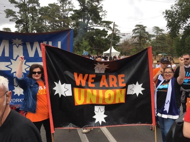
Photograph: Labour Day March - Ballarat - 2019, 11/3/19
Labour Day originates from the eight-hour day movement - eight hours for work, eight hours for recreation, and eight hours for rest. On 21 April 1856 Stonemasons and building workers on building sites around Melbourne, Australia, stopped work and marched from the University of Melbourne to Parliament House to achieve an eight-hour day. Their direct action protest was a success, and they are noted as the first organised workers in the world to achieve an eight-hour day with no loss of pay, which subsequently inspired the celebration of Labour Day and May Day. (Wikipedia, 12 March 2019: https://en.wikipedia.org/wiki/Public_holidays_in_Australia#Labour_Day) The eight-hours campaign ran contemporaneously in Ballarat. -------- The Labour day parade is an annual event in Ballarat. All unions and individuals are welcome to attend. Ballarat Labour Day march is held at the same date as the Begonia Festival parade; inception of the Begonia Festival was several decades later in 1953. -------- Photo 1 Labour Day march: We are Union banner and AMIWU banner with people. Photo 2 Labour Day march: We are Union, Trades Hall, Free West Papua banners, Trades Hall ute, various individuals including Don Henderson, Jenny Beacham, Tracey Brown, Simon Hammersley, Moses, Ben Davison, Angela McCarthy, Eddie Beacham, Gary Carton, Bob Bassett, Colin Muir, et al. Photo 3 Labour Day march: We are Union, ANMF, Trades Hall banners, various individuals including Don Henderson, Jenny Beacham, Tracey Brown, Simon Hammersley, Moses, Ben Davison, Angela McCarthy, Eddie Beacham, Gary Carton, Bob Bassett, Colin Muir, Ron Woods et al. Photo 4 Labour Day march: Change the Rules and AMIWU banners, various persons including Chris Kelly, Angela McCarthy, Ross Kenna, et al. Photo 5 Labour Day barbeque: Various persons including Allen Townsend, Fred Ladiges, Cameron McIntyre, Judy Henderson, Don Henderson, Cameron Bannam, Janine Brownlee, Dave Brownlee, Bernie Constable, Ian Fullerton, Ben Davison, et al. Photo 6 Labour Day barbeque group photograph: Various persons including Moses, Emma Pritchard, Kamuda, Allen Townsend, Tess Marshall, Chris Kelly, Fred Ladiges, Ross Kenna, Ben Davison, Don Henderson, Judy Henderson, Gabriel Waldron, Cameron McIntyre, Orry Pilven, Lana Cormie, Bob Bassett, Clinton Bannam, Angela McCarthy, Tracey Brown, Ron Woods, Ian Fullerton, Colin Muir, et al. Photo 7 Labour Day barbeque group photograph: Various persons including Moses, Emma Pritchard, Kamuda, Allen Townsend, Tess Marshall, Chris Kelly, Fred Ladiges, Ross Kenna, Ben Davison, Don Henderson, Judy Henderson, Gabriel Waldron, Cameron McIntyre, Orry Pilven, Lana Cormie, Bob Bassett, Clinton Bannam, Angela McCarthy, Tracey Brown, Ron Woods, Ian Fullerton, Colin Muir, et al. Photo 8 Labour Day March: We are Union banner, various persons including Chris Kelly, Angela McCarthy, Clinton Bannam, Orrie and Gem Pilven, Janine Brownlee, et al.Significant to the inception of the eight hour day, history of unions and campaigns in Australia and the current Change the Rules campaign.8 colour photographs; soft copy.btlc, ballarat trades hall, ballarat trades and labour council, labour day - 2019, unions - delegates, change the rules, amiwu, anmf, we are union, unions - campaigns, early closing association, begonia festival - ballarat -
 Hume City Civic Collection
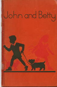
Book - School Reader, John and Betty, 1954
The school reader was published by the Victorian Education Department and was the official reader for the Preparatory grades throughout Victorian school.A twenty four paged book with an orange cardboard cover and stapled together with the title 'John and Betty' printed in dark green lettering and a silhouette picture of a boy and girl with a dog in dark green and red.non-fictionThe school reader was published by the Victorian Education Department and was the official reader for the Preparatory grades throughout Victorian school.school readers, victorian education department, john and betty -
 8th/13th Victorian Mounted Rifles Regimental Collection
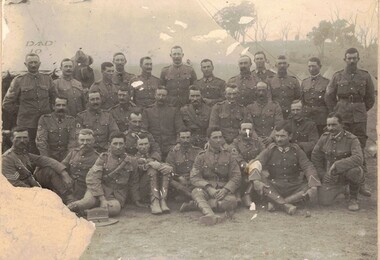
Photograph - Born digital image
... throughout the year. Study of citizen soldiers in first decade ...8th Australian Light Horse Regiment was raised following Federation from companies of the Victorian Mounted Rifles in North East Victoria. It was an all volunteer force of citizen soldiers. The annual encampment, usually conducted over the Easter break, was the culmination of training conducted in local areas throughout the year. Study of citizen soldiers in first decade following FederationDamaged black and white photograph of group of soldiers of the 8th Light horse Regiment at Seymour 1908.Seymour 1908. / Sgt W Luscombe 2nd right centre row. / Holder of the Local Forces Victoria Long Service and / Good Conduct Medal, also holder of the Colonial Forces / Long Service Medal. / Donated by I Errey Baddaginnie.seymour, light horse, luscombe -
 Wangaratta High School
WHS Newspaper Cutting/Photo History Collection, 1909-2009
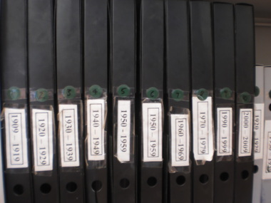
10 Black folders, each containing newspaper cuttings and photographic memorabilia from a decade of WHS history, spanning 1909-2009, the first centaury of the schools opening. -
Moorabbin Air Museum
Document (Item) - Draft of Speech Regarding the Potential of Aviation Developments in the 1970s, Speakers Notes
The speech, drafted in January 1968, was looking forward to the 1970s as a decade of "exciting developments" -
 Bendigo Historical Society Inc.
Slide - DIGGERS & MINING. DIGGERS AND MINING
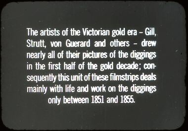
Diggers & Mining: Diggers & Mining.Silde reads: The artists of the Victorian gold era - Gill, Strutt, von Guerard and others - drew nearly all of their pictures of the diggings in the first half of the gold decade: con-sequently this unit of these filmstrips deals mainly with life and work on the diggings only between 1851 and 1855. Markings:54/ 994:LIF1. Used as a teaching aid.hanimounteducation, tertiary, diggers & miners -
 Bayside Gallery - Bayside City Council Art & Heritage Collection
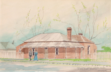
Work on paper - watercolour, John C. Paul, Adam Lindsay Gordon cottage c. 1870, 1973
The famous Australian poet Adam Lindsay Gordon (1833-1870) lodged for seventeen months in this cottage, located at 10 Lewis Street, Brighton. He and his wife Margaret lived here from 1869 until Gordon took his life on the Brighton foreshore in June 1970. Adam Gordon Lindsay was the first Australian poet to gain considerable recognition overseas and has been credited for beginning a national school of Australian poetry. His poetry reflected his love of the bush, a sense of humour, but also his battle with depression. In addition to being a poet, Lindsay was also a skilled horseman, police officer and politician. In 1946, the cottage at 10 Lewis Street was demolished. Local poet Mr Cyril Good, an ardent admirer of Adam Lindsay Gordon, purchased the bricks from the cottage which he carefully numbered and stored for a number of decades, in the hope that it would one day be re-erected in Gordon’s honour. John C. Paul, Adam Lindsay Gordon cottage c. 1870 1973, watercolour, 27.8 x 42.3 cm. Bayside City Council Art and Heritage Collection. Purchased 1974.brighton, john c paul, historic house, adam lindsay gordon, poet, lewis street, politician -
 Bendigo Historical Society Inc.
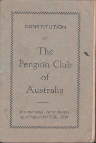
Booklet - Constitution - Penguin Club of Australia
Speaking Made Easy is a registered name of The Penguin Club of Australia Inc which was founded in Sydney in 1937 by women for women. The late M. Jean Ellis O.B.E. was the co-founder of the Penguin Club and developed the organisation in each State and Territory of Australia, and in Port Moresby and Mount Hagen in Papua New Guinea. In an era when women were not so active in public life, one woman’s courage and foresight has inspired members during the decades to continue to support women to develop their speaking skills and become articulate, confident women in all aspects of their lives. Well-known Penguin Club members have included the late Margaret Whitlam, wife of the late former Prime Minister Gough Whitlam; Mary Tenison Woods, first female lawyer and public notary in SA; and Gertrude Johnson, Australian coloratura soprano and founder of the National Theatre in Melbourne.Grey cover booklet. The booklet has twenty pages and is titled the constitution of the Penguin Club of Australia. Incorporating amendments up to September 30th, 1949. published by Oxford Press, 2-4 Bedford St. Sydney. Aileen and John Ellison Collection.penguin club, consitution -
 Kew Historical Society Inc
Plan, Melbourne & Metropolitan Board of Works : Borough of Kew : Detail Plan No.1576, 1904
... of construction materials used in buildings in the first decade ...The Melbourne and Metropolitan Board of Works (MMBW) plans were produced from the 1890s to the 1950s. They were crucial to the design and development of Melbourne's sewerage and drainage system. The plans, at a scale of 40 feet to 1 inch (1:480), provide a detailed historical record of Melbourne streetscapes and environmental features. Each plan covers one or two street blocks (roughly six streets), showing details of buildings, including garden layouts and ownership boundaries, and features such as laneways, drains, bridges, parks, municipal boundaries and other prominent landmarks as they existed at the time each plan was produced. (Source: State Library of Victoria)This plan forms part of a large group of MMBW plans and maps that was donated to the Society by the Mr Poulter, City Engineer of the City of Kew in 1989. Within this collection, thirty-five hand-coloured plans, backed with linen, are of statewide significance as they include annotations that provide details of construction materials used in buildings in the first decade of the 20th century as well as additional information about land ownership and usage. The copies in the Public Record Office Victoria and the State Library of Victoria are monochrome versions which do not denote building materials so that the maps in this collection are invaluable and unique tools for researchers and heritage consultants. A number of the plans are not held in the collection of the State Library of Victoria so they have the additional attribute of rarity.Original survey plan, issued by the MMBW to a contractor with responsibility for constructing sewers in the area identified on the plan within the Borough of Kew. The plan was at some stage hand-coloured, possibly by the contractor, but more likely by officers working in the Engineering Department of the Borough and later Town, then City of Kew. The hand-coloured sections of buildings on the plan were used to denote masonry or brick constructions (pink), weatherboard constructions (yellow), and public buildings (grey). Development in the 20th century has irreparably altered that part of Kew represented in this plan. In the block bounded by Cotham Road, Charles Street, Wellington Street and Gellibrand; just one house standing in 1903 remains. This block included two of the most historic houses in Kew: ‘Ordsall’ (later ‘Southesk’) and ‘Madford’ (previously ‘Elm Lodge’). Ordsall was the home of the second chairman of Kew, John Halfey. It contained some of the most significant interior murals in Kew, created for Halfey by artists working for Cullen & Co. It was demolished in 1960 to make way for the Kew Civic Centre. Elm Lodge had been built for William Siddeley in ca. 1864. Arthur Septimus King purchased it in 1874. The lower paddocks of Madford were sold in 1905 by his wife to the Borough of Kew and, after landscaping by George and Thomas Pockett, opened as the Alexandra Gardens in 1908. Elm Lodge/Madford was in 1922 to become St. Anthony’s Home for Little Children before its subsequent demolition in the 1980s.melbourne and metropolitan board of works, detail plans, maps - borough of kew, mmbw 1576, cartography -
 Kew Historical Society Inc
Plan, Borough of Kew Detail Plan No.1577, 1904
... of construction materials used in buildings in the first decade ...The Melbourne and Metropolitan Board of Works (MMBW) plans were produced from the 1890s to the 1950s. They were crucial to the design and development of Melbourne's sewerage and drainage system. The plans, at a scale of 40 feet to 1 inch (1:480), provide a detailed historical record of Melbourne streetscapes and environmental features. Each plan covers one or two street blocks (roughly six streets), showing details of buildings, including garden layouts and ownership boundaries, and features such as laneways, drains, bridges, parks, municipal boundaries and other prominent landmarks as they existed at the time each plan was produced. (Source: State Library of Victoria)This plan forms part of a large group of MMBW plans and maps that was donated to the Society by the Mr Poulter, City Engineer of the City of Kew in 1989. Within this collection, thirty-five hand-coloured plans, backed with linen, are of statewide significance as they include annotations that provide details of construction materials used in buildings in the first decade of the 20th century as well as additional information about land ownership and usage. The copies in the Public Record Office Victoria and the State Library of Victoria are monochrome versions which do not denote building materials so that the maps in this collection are invaluable and unique tools for researchers and heritage consultants. A number of the plans are not held in the collection of the State Library of Victoria so they have the additional attribute of rarity.Original survey plan, issued by the MMBW to a contractor with responsibility for constructing sewers in the area identified on the plan within the Borough of Kew. The plan was at some stage hand-coloured, possibly by the contractor, but more likely by officers working in the Engineering Department of the Borough and later Town, then City of Kew. The hand-coloured sections of buildings on the plan were used to denote masonry or brick constructions (pink), weatherboard constructions (yellow), and public buildings (grey). MMBW Plan No.1577 includes some of the most significant houses in Kew: Herbert Henty’s ‘Roxeth’ (now part of Trinity Grammar), ‘Butleigh Wooton’, ‘Bokara’ and ‘Harrow’. It also includes the streets that have since changed their names. That part of College Parade linked to Glenferrie Road is now named College Place, College Parade now extends further north, and Charles Street did not yet reach Barkers Road. Roxeth is one of a number of Henty houses in Kew. Herbert Henty made his home here and was elected a member of Kew Municipal Council in 1864 and mayor in 1868-69. Walter Henry Serle, of Harrow served in the First World War. He was awarded the Military Medal ‘’For conspicuous bravery and devotion to duty. On 29th September near BELLICOURT he showed the greatest bravery and determination when his platoon was attacked by enemy bombing parties. It was due largely to his personal efforts that all the attacks were repulsed. Until wounded, his utter disregard of personal safety and boldness in dealing with the attacks were the means of saving the situation and were an inspiring example to his men.’melbourne and metropolitan board of works, detail plans, maps - borough of kew, mmbw 1577, cartography -
 Kew Historical Society Inc
Plan, Melbourne & Metropolitan Board of Works : Borough of Kew : Detail Plan No.1578, 1904
... of construction materials used in buildings in the first decade ...The Melbourne and Metropolitan Board of Works (MMBW) plans were produced from the 1890s to the 1950s. They were crucial to the design and development of Melbourne's sewerage and drainage system. The plans, at a scale of 40 feet to 1 inch (1:480), provide a detailed historical record of Melbourne streetscapes and environmental features. Each plan covers one or two street blocks (roughly six streets), showing details of buildings, including garden layouts and ownership boundaries, and features such as laneways, drains, bridges, parks, municipal boundaries and other prominent landmarks as they existed at the time each plan was produced. (Source: State Library of Victoria). This plan forms part of a large group of MMBW plans and maps that was donated to the Society by the Mr Poulter, City Engineer of the City of Kew in 1989. Within this collection, thirty-five hand-coloured plans, backed with linen, are of statewide significance as they include annotations that provide details of construction materials used in buildings in the first decade of the 20th century as well as additional information about land ownership and usage. The copies in the Public Record Office Victoria and the State Library of Victoria are monochrome versions which do not denote building materials so that the maps in this collection are invaluable and unique tools for researchers and heritage consultants. A number of the plans are not held in the collection of the State Library of Victoria so they have the additional attribute of rarity.Original survey plan, issued by the MMBW to a contractor with responsibility for constructing sewers in the area identified on the plan within the Borough of Kew. The plan was at some stage hand-coloured, possibly by the contractor, but more likely by officers working in the Engineering Department of the Borough and later Town, then City of Kew. The hand-coloured sections of buildings on the plan were used to denote masonry or brick constructions (pink), weatherboard constructions (yellow), and public buildings (grey). MMBW Plan No.1578 is significant in that it defines the extent of two private schools: Xavier College and Kew High School (now part of Trinity Grammar) by 1904. In relation to the latter, the plan clarifies which buildings the High School operated from behind the mansion ‘Molina’. Established in 1902, Trinity Grammar was to later lease and subsequently buy Molina (now ‘Merritt House’) and ‘Elsinore’ (now ‘Roberts House’). Xavier College had been established in 1872. This 1904 plan delineates the West Wing and the Great Hall (built in 1890).melbourne and metropolitan board of works, detail plans, maps - borough of kew, mmbw 1578, cartography -
 Kew Historical Society Inc
Plan, Melbourne & Metropolitan Board of Works. Borough of Kew Detail Plan No.1579, 1904
... of construction materials used in buildings in the first decade ...The Melbourne and Metropolitan Board of Works (MMBW) plans were produced from the 1890s to the 1950s. They were crucial to the design and development of Melbourne's sewerage and drainage system. The plans, at a scale of 40 feet to 1 inch (1:480), provide a detailed historical record of Melbourne streetscapes and environmental features. Each plan covers one or two street blocks (roughly six streets), showing details of buildings, including garden layouts and ownership boundaries, and features such as laneways, drains, bridges, parks, municipal boundaries and other prominent landmarks as they existed at the time each plan was produced. (Source: State Library of Victoria). This plan forms part of a large group of MMBW plans and maps that was donated to the Society by the Mr Poulter, City Engineer of the City of Kew in 1989. Within this collection, thirty-five hand-coloured plans, backed with linen, are of statewide significance as they include annotations that provide details of construction materials used in buildings in the first decade of the 20th century as well as additional information about land ownership and usage. The copies in the Public Record Office Victoria and the State Library of Victoria are monochrome versions which do not denote building materials so that the maps in this collection are invaluable and unique tools for researchers and heritage consultants. A number of the plans are not held in the collection of the State Library of Victoria so they have the additional attribute of rarity.Original survey plan, issued by the MMBW to a contractor with responsibility for constructing sewers in the area identified on the plan within the Borough of Kew. The plan was at some stage hand-coloured, possibly by the contractor, but more likely by officers working in the Engineering Department of the Borough and later Town, then City of Kew. The hand-coloured sections of buildings on the plan were used to denote masonry or brick constructions (pink), weatherboard constructions (yellow), and public buildings (grey). While MMBW Plan No.1579 does not include many buildings, those that it does show are significant to Kew’s history. These include the ‘Kew [Railway] Station’ in Denmark Street and the ‘Recreation Hall’ and rear courts off Wellington Street. The plan shows the outline of the Recreation Hall, constructed in 1880, at the rear of which is listed a bowling green, two tennis courts, a ‘skittle alley’ and a pavilion. When the Hall was first built, the Kew Cricket Club occupied an adjacent ground, however in 1885 this was acquired by the State Government as the future location of the Kew Railway Station. The Plan also shows a single oval at Xavier College. This oval was completed in 1883. One of the current ovals conforms to this oval’s original shape and position in the school grounds.melbourne and metropolitan board of works, detail plans, maps - borough of kew, mmbw 1579, cartography -
 Kew Historical Society Inc
Plan, Melbourne and Metropolitan Board of Works, Borough of Kew : Detail Plan No.1580, 1904
... of construction materials used in buildings in the first decade ...The Melbourne and Metropolitan Board of Works (MMBW) plans were produced from the 1890s to the 1950s. They were crucial to the design and development of Melbourne's sewerage and drainage system. The plans, at a scale of 40 feet to 1 inch (1:480), provide a detailed historical record of Melbourne streetscapes and environmental features. Each plan covers one or two street blocks (roughly six streets), showing details of buildings, including garden layouts and ownership boundaries, and features such as laneways, drains, bridges, parks, municipal boundaries and other prominent landmarks as they existed at the time each plan was produced. (Source: State Library of Victoria)This plan forms part of a large group of MMBW plans and maps that was donated to the Society by the Mr Poulter, City Engineer of the City of Kew in 1989. Within this collection, thirty-five hand-coloured plans, backed with linen, are of statewide significance as they include annotations that provide details of construction materials used in buildings in the first decade of the 20th century as well as additional information about land ownership and usage. The copies in the Public Record Office Victoria and the State Library of Victoria are monochrome versions which do not denote building materials so that the maps in this collection are invaluable and unique tools for researchers and heritage consultants. A number of the plans are not held in the collection of the State Library of Victoria so they have the additional attribute of rarity.Original survey plan, issued by the MMBW to a contractor with responsibility for constructing sewers in the area identified on the plan within the Borough of Kew. The plan was at some stage hand-coloured, possibly by the contractor, but more likely by officers working in the Engineering Department of the Borough and later Town, then City of Kew. The hand-coloured sections of buildings on the plan were used to denote masonry or brick constructions (pink), weatherboard constructions (yellow), and public buildings (grey). The area represented in this detail plan has undergone significant change during the 20th century. The widening of High Street in the 1930s and 1950s involved the shops on the south side of High Street being demolished and later rebuilt to fit the widened street. Another significant loss was the mansion ‘Drayton’ fronting Wellington Street, owned at this stage by Susannah Fenton. Her family name would later to be given to Fenton Way, which was to be built over the grounds of the house following its demolition. The plan of the garden is particularly interesting, containing a batten dome fronting Wellington Street, an ornamental pond, a fountain and a brick and glass conservatory. The notes by the plumbing contractor on this plan are particularly detailed. Pink borders delineate the ownership of the varying parcels of land. Some of the better known owners listed include the real estate agent Cr. Henry de Castres Kellett (bt) and John Padbury, the funeral director. This particular plan provides a clear view of the configuration of the Kew Junction in 1903 and the commercial buildings that surrounded it.melbourne and metropolitan board of works, detail plans, maps - borough of kew, mmbw 1580, cartography -
 Kew Historical Society Inc
Plan, Melbourne & Metropolitan Board of Works : Borough of Kew : Detail Plan No.1581, 1904
... of construction materials used in buildings in the first decade ...The Melbourne and Metropolitan Board of Works (MMBW) plans were produced from the 1890s to the 1950s. They were crucial to the design and development of Melbourne's sewerage and drainage system. The plans, at a scale of 40 feet to 1 inch (1:480), provide a detailed historical record of Melbourne streetscapes and environmental features. Each plan covers one or two street blocks (roughly six streets), showing details of buildings, including garden layouts and ownership boundaries, and features such as laneways, drains, bridges, parks, municipal boundaries and other prominent landmarks as they existed at the time each plan was produced. (Source: State Library of Victoria)This plan forms part of a large group of MMBW plans and maps that was donated to the Society by the Mr Poulter, City Engineer of the City of Kew in 1989. Within this collection, thirty-five hand-coloured plans, backed with linen, are of statewide significance as they include annotations that provide details of construction materials used in buildings in the first decade of the 20th century as well as additional information about land ownership and usage. The copies in the Public Record Office Victoria and the State Library of Victoria are monochrome versions which do not denote building materials so that the maps in this collection are invaluable and unique tools for researchers and heritage consultants. A number of the plans are not held in the collection of the State Library of Victoria so they have the additional attribute of rarity.Original survey plan, issued by the MMBW to a contractor with responsibility for constructing sewers in the area identified on the plan within the Borough of Kew. The plan was at some stage hand-coloured, possibly by the contractor, but more likely by officers working in the Engineering Department of the Borough and later Town, then City of Kew. The hand-coloured sections of buildings on the plan were used to denote masonry or brick constructions (pink), weatherboard constructions (yellow), and public buildings (grey). The streets and built structures in this plan were surveyed in 1903 and released to contractors in 1904. In addition to the designation of building types by colour, the plan includes detailed descriptions of land use and ownership. While many buildings remain from this period, a number of the buildings represented have been demolished including the original Kew Town Hall, and the Congregational and Roman Catholic churches in Walpole Street. While the mansion ‘Illapa’ in Princess Street is still extant – now part of ‘Rylands’ – the neighbouring mansion ‘Elsmere’ was demolished some decades ago. Rivalling Illapa and Elsmere in size were two mansions in Walpole Street, one named on the plan as ‘Gnarlbine’. Over time, Kew Junction and the south side of High Street have been reconfigured and widened, so that the commercial buildings on the corner of Princess and High Street no longer exist. A surprising feature of this part of central Kew to the northwest of Kew Junction is the amount of vacant land. In a number of cases, this land is noted by the contractor as used for vegetable gardens.melbourne and metropolitan board of works, detail plans, maps - borough of kew, mmbw 1581, cartography -
 Kew Historical Society Inc
Plan, Melbourne & Metropolitan Board of Works : Borough of Kew : Detail Plan No.1582, 1904
... of construction materials used in buildings in the first decade ...The Melbourne and Metropolitan Board of Works (MMBW) plans were produced from the 1890s to the 1950s. They were crucial to the design and development of Melbourne's sewerage and drainage system. The plans, at a scale of 40 feet to 1 inch (1:480), provide a detailed historical record of Melbourne streetscapes and environmental features. Each plan covers one or two street blocks (roughly six streets), showing details of buildings, including garden layouts and ownership boundaries, and features such as laneways, drains, bridges, parks, municipal boundaries and other prominent landmarks as they existed at the time each plan was produced. (Source: State Library of Victoria)This plan forms part of a large group of MMBW plans and maps that was donated to the Society by the Mr Poulter, City Engineer of the City of Kew in 1989. Within this collection, thirty-five hand-coloured plans, backed with linen, are of statewide significance as they include annotations that provide details of construction materials used in buildings in the first decade of the 20th century as well as additional information about land ownership and usage. The copies in the Public Record Office Victoria and the State Library of Victoria are monochrome versions which do not denote building materials so that the maps in this collection are invaluable and unique tools for researchers and heritage consultants. A number of the plans are not held in the collection of the State Library of Victoria so they have the additional attribute of rarity.Original survey plan, issued by the MMBW to a contractor with responsibility for constructing sewers in the area identified on the plan within the Borough of Kew. The plan was at some stage hand-coloured, possibly by the contractor, but more likely by officers working in the Engineering Department of the Borough and later Town, then City of Kew. The hand-coloured sections of buildings on the plan were used to denote masonry or brick constructions (pink), weatherboard constructions (yellow), and public buildings (grey). Public buildings, coloured grey on the Plan 1582 include the police station and post office, churches and schools. The earliest church school, Common School No.356 was located at the rear of the Congregational Church in Peel Street. It was constructed in 1859. The first buildings of Kew Primary School No.1075 on the other side of Peel Street were constructed in 1871. The school in 1903 only occupied a small fraction of its current site. In 1903, where the rear playground is now located, were two weatherboard and one brick villa. Trinity Grammar School was founded in 1902 and opened in the Parish Hall at the rear of Holy Trinity Anglican Church. It was not to move to its current site until 1906. The outline of the building housing the Kew Fire Brigade in the centre of the north side of Walton Street is shown but not named on the plan. Further down Pakington Street stood the two-storey Italianate mansion ‘Overton’. The home of Stanford Chapman, it was to be featured in the Imperial Institute series of bromide photographs of Victoria, Vol. 1: Homes and scenery. It was later to become a boarding house before it was later demolished.melbourne and metropolitan board of works, detail plans, maps - borough of kew, mmbw 1582, cartography -
 Kew Historical Society Inc
Plan, Melbourne & Metropolitan Board of Works : Borough of Kew : Detail Plan No.1585, 1904
... of construction materials used in buildings in the first decade ...The Melbourne and Metropolitan Board of Works (MMBW) plans were produced from the 1890s to the 1950s. They were crucial to the design and development of Melbourne's sewerage and drainage system. The plans, at a scale of 40 feet to 1 inch (1:480), provide a detailed historical record of Melbourne streetscapes and environmental features. Each plan covers one or two street blocks (roughly six streets), showing details of buildings, including garden layouts and ownership boundaries, and features such as laneways, drains, bridges, parks, municipal boundaries and other prominent landmarks as they existed at the time each plan was produced. (Source: State Library of Victoria)This plan forms part of a large group of MMBW plans and maps that was donated to the Society by the Mr Poulter, City Engineer of the City of Kew in 1989. Within this collection, thirty-five hand-coloured plans, backed with linen, are of statewide significance as they include annotations that provide details of construction materials used in buildings in the first decade of the 20th century as well as additional information about land ownership and usage. The copies in the Public Record Office Victoria and the State Library of Victoria are monochrome versions which do not denote building materials so that the maps in this collection are invaluable and unique tools for researchers and heritage consultants. A number of the plans are not held in the collection of the State Library of Victoria so they have the additional attribute of rarity.Original survey plan, issued by the MMBW to a contractor with responsibility for constructing sewers in the area identified on the plan within the Borough of Kew. The plan was at some stage hand-coloured, possibly by the contractor, but more likely by officers working in the Engineering Department of the Borough and later Town, then City of Kew. The hand-coloured sections of buildings on the plan were used to denote masonry or brick constructions (pink), weatherboard constructions (yellow), and public buildings (grey). This plan, which covers parts of High Street, Pakington Street and Derby Street is dominated by two historic Kew mansions: ‘Konetta’ and ‘Ramornie’. Ramornie was constructed in 1890 for James Maitland Campbell, three times Mayor of Kew. Sold in 1940, it became a boarding house known as ‘The Towers’. Now a private residence again, it has only one of its three balconies remaining. The location of the missing two balconies can be seen on the plan. In 1903, the grounds of Ramornie included a large tennis court fronting Pakington Street. The rear of the property is shown as extending to Cobden Street. One of Kew’s oldest hotels, the Prospect Hill Hotel on the corner of High and Cobden Street was established in 1858. The outline of the hotel shown on the plan represents the second building on the site. During the 19th century it was often used for electoral meetings. The Prospect Hill Hotel was to be redeveloped again in 1928, by the local architect Robert McIntyre. Since the 1980s, the hotel has been a live music venue, the home of the Melbourne Jazz Club, a restaurant and a liquor outlet.melbourne and metropolitan board of works, detail plans, maps - borough of kew, mmbw 1585, cartography -
 Kew Historical Society Inc
Plan, Melbourne & Metropolitan Board of Works : Borough of Kew : Detail Plan No.1588, 1904
... of construction materials used in buildings in the first decade ...The Melbourne and Metropolitan Board of Works (MMBW) plans were produced from the 1890s to the 1950s. They were crucial to the design and development of Melbourne's sewerage and drainage system. The plans, at a scale of 40 feet to 1 inch (1:480), provide a detailed historical record of Melbourne streetscapes and environmental features. Each plan covers one or two street blocks (roughly six streets), showing details of buildings, including garden layouts and ownership boundaries, and features such as laneways, drains, bridges, parks, municipal boundaries and other prominent landmarks as they existed at the time each plan was produced. (Source: State Library of Victoria)This plan forms part of a large group of MMBW plans and maps that was donated to the Society by the Mr Poulter, City Engineer of the City of Kew in 1989. Within this collection, thirty-five hand-coloured plans, backed with linen, are of statewide significance as they include annotations that provide details of construction materials used in buildings in the first decade of the 20th century as well as additional information about land ownership and usage. The copies in the Public Record Office Victoria and the State Library of Victoria are monochrome versions which do not denote building materials so that the maps in this collection are invaluable and unique tools for researchers and heritage consultants. A number of the plans are not held in the collection of the State Library of Victoria so they have the additional attribute of rarity.Original survey plan, issued by the MMBW to a contractor with responsibility for constructing sewers in the area identified on the plan within the Borough of Kew. The plan was at some stage hand-coloured, possibly by the contractor, but more likely by officers working in the Engineering Department of the Borough and later Town, then City of Kew. The hand-coloured sections of buildings on the plan were used to denote masonry or brick constructions (pink), weatherboard constructions (yellow), and public buildings (grey). This plan shows the original configuration of the Kew Post Office, Court House and Police Station, which had opened in 1888. This configuration was to essentially remain until the purchase of the Court House and Police Station by the City of Boroondara in 2007 and its subsequent renovation. Interestingly, the MMBW surveyors incorrectly labelled parts of the complex. In the triangle in front of the Post Office, before the erection of the Kew Cenotaph in 1925, was located a lawn and the Queen Victoria Jubilee Fountain. While many of the shops on the south side of High street had been constructed by 1903 a number of sites were still used as vegetable gardens. Further along High Street, on the corner of Charles Street, the Salvation Army Barracks can be seen on the plan. These Barracks predate the later Citadel and ‘Young People’s Hall’ that were opened in 1919. At 22 Charles Street can be seen the house of James Venn Morgan. Hailed as the ‘father of Kew’, Morgan arrived in Melbourne in 1840. He was first engaged as a bookmaker, but a fortunate venture on the goldfields enabled him to purchase land in Kew. He conducted a market garden and dairy in Kew for many years.melbourne and metropolitan board of works, detail plans, maps - borough of kew, mmbw 1588, cartography