Showing 356 items
matching geology of victoria
-
 Stawell Historical Society Inc
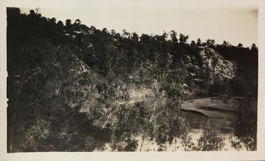
Book - Science, The Natural History of Western Victoria, 1974
Reports from Symposium of Australian Insitutes of Agricultural Science, held in Horsham 1971. 8 chapters, 7 of science 8th extracts from Stapylton's Journal of Western Victoria, when travlling with Major Mitchell. Contains fold out Maps & photos. 1) Geology & Geomorphology 2) Soils 3) Vegitation 4) Birds 6) Aborigines 7) the first hundred years of agricultural development 8) The Journal of Granville William Chetwynd StapyltonSoft Yellow Cover and Black with Black taped spineBarry Clugston -
Stawell Historical Society Inc
Map, Department of Mines Victoria, Alluvial Map Stawell Region, 1870's
c1870 Coloured map showing Black Range North to Stawell and Illawarra. Shows geological layout.Department Mines Victoria 1952/G/2 mining, gold, map -
Koorie Heritage Trust
Journal - Serials, Birdsell, Joseph B. et al, Records of the Queen Victoria Museum Launceston. Contents - The racial origins of the Extinct Tasmanians. A survey of possible sea routes available to the Tasmanian Aborigines. The Tasmanians - a summary, 1949
Some of the points raised seem rather dated, but an interesting set of theories historically.105-145P.; plates; refs. figs.Some of the points raised seem rather dated, but an interesting set of theories historically.tasmanians - racial origins., australian aboriginals - origins., migration theories - tasmanians., bass strait - geology. -
Koorie Heritage Trust
Book, Baragwanath, W, Memoirs of the Geological Survey of Victoria : No. 15 The Aberfeldy District, Gippsland, 1925
... LCSH: 1. Geology -- Victoria -- Periodicals. 2. Geology... Federation Square, Melbourne melbourne LCSH: 1. Geology -- Victoria ...15 v. : ill., plates, maps, plans, diagrs. ; 34 cm. lcsh: 1. geology -- victoria -- periodicals. 2. geology -- victoria. i. geological survey of victoria. ii. victoria. dept. of mines. -
 Rutherglen Historical Society
Map, 1908
This is a map produced as part of a book entitled.. It is also stamped on the back in blue ink with an oval ring and the words North of England Institute. Newcastle. Mining & Meterolgical Faculty. Purchased on 23rd July 2017 by the Society after research by member Simon Killeen. Mining map of one of the first mines in Rutherglen area ( Chiltern West)Cream paper, black printing, rectangle with a drawingGeographical Survey of Victoria, Memoir, No6. Plate XX Plan of Underground Workings CHILTERN VALLEY CONSOLS MINE, RUTHERGLEN, PARISH OF CHILTERN WESTgold, rutherglen, mining, chiltern, underground mine map, geological survey, reef drives -
 Ballarat Heritage Services
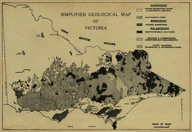
Map, Simplified Geological Map of Victoria, c1940, c1940
... Office goldfields victoria map geology geological Physiographic ...Physiographic map of Victoriavictoria, map, geology, geological -
 Ballarat Heritage Services
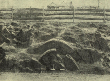
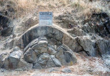
Photograph - Image, Anticlinal Fold, Lyttleton Street, Castlemaine, c1880, c1880
In 1927 a plaque was installed at this anticlinal fold. Since no plaque is evident in the photo the date would be pre1927. The plaque states "This fine exhibit was disclosed when Lyttleton Street East was constructed in 1874. Saddle reefs occur in similar folds of the sandstones and slates on lower geological horizons." An anticline at Castlemaine, Victoria. This natural feature was uncovered during Lyttleton Street roadworks in 1880. anticlinal fold, geology, castlemaine -
 Ballarat Heritage Services
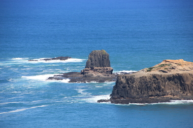
Digital photographs, L.J. Gervasoni, Cape Schank, Victoria, 2016, 2016
Colour photograph of Rocky crop at Cap Schank.coast, coastal, coastal geomorphology, geology, ocean, waves, cape schank, beach -
 Ballarat Heritage Services
Photograph - Digital photographs, L.J. Gervasoni, Tower Hill - international geological significance - maar, c2015
... landscape ash geological international significance Digital ...Digital Photographs of tower hill near Koroit Victoria tower hill, volcano, natural heritage, koroit, landscape, ash, geological, international significance -
 Ballarat Heritage Services
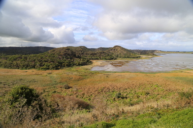
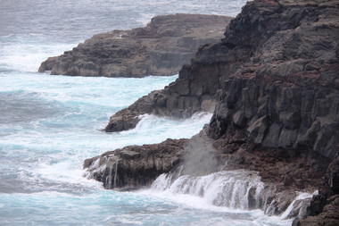
Digital photograph, Lisa Gervasoni, Cape Bridgewater, c2015
Colour photograph of the coastline at Cape Bridgewater, Victoria. cape bridgewater, geology, ocean, coastal, landscape, seascape, blowhole, volcanic rock -
 Ballarat Heritage Services
Photograph - Photograph - Colour, Clare Gervasoni, Anticlinal Fold, Castlemaine, c2007
In 1927 a plaque was installed at this anticlinal fold. Since no plaque is evident in the photo the date would be pre1927. The plaque states "This fine exhibit was disclosed when Lyttleton Street East was constructed in 1874. Saddle reefs occur in similar folds of the sandstones and slates on lower geological horizons."Colour photograph of an anticlinal fold in Lyttleton Street, Castlemaine, Victoriaanticlinal fold, geology, geological feature, castlemaine -
 Ballarat Heritage Services
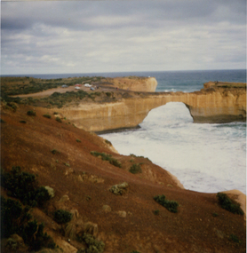
Photograph, London Bridge, Great Ocean Road, 01/1990
London Bridge, pre 1990 was a double-spanning bridge connected to the mainland. The stack was created over hundreds of years, with the weaker layers toward the base being eroded away by wind and water to form the two bridges. The span closer to the shoreline collapsed unexpectedly on 15 January 1990, leaving two visitors, whilst uninjured, stranded on the outer span before being rescued by helicopter. Two coloured photographs of the London Bridge, on the Great Ocean Road. This photo was taken days before the collapse of the geological feature. The photographer walked across the bridge to the warning of her mother "if you go over there and it collapses you will be stuck. After the collapse it was renamed London Arch. london bridge, great ocean road, london bridge, peterborough, london arch, shipwreck coast, 12 apostles -
 Ballarat Heritage Services
Photograph - Photograph - Colour, Clare Gervasoni, Pulpit Rock, Magpie, Victoria, 2019, 18/05/2019
Wesleyans at Magpie collected money to built a tent chapel at Magpie, but the rush had moved on before it was erected so the tent was taken to Ballarat where it becme the basis of the Lydiard Street Wesleyan Church (now Uniting Church). A bluestone church was later bulit above the Magpie School which was demolished in the 1960s with the stone used in the entrance building at Sovereign Hill.A large rock at Magpie, beside the Yarrowee Creek, was called Pulpit Rock. It was at this rock that the early miners gathered in 1853 for open air religious services. magpie, wesleyan church, religion, pulpit rock, geology -
 Bendigo Historical Society Inc.
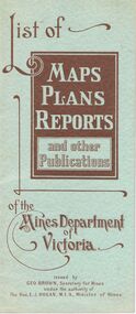
Document - LIST OF MAPS, PLANS, REPORTS PUBLISHED BY MINES DEPARTMENT VICTORIA 1938
Blue booklet, on front ' List of Maps, Plans, Reports and other publications of the Mines Department of Victoria. Issued by Geo Brown Secretary for Mines under the authority of The Hon. E.J. Hogan, MLA, Minister of Mines. Booklet contains list of publications of geological reports, maps etc for Ararat, Ballarat, Beechworth, Bendigo, Castlemaine, Gippsland, Maryborough.Geo Brown, Secretary for Mines under the authority of The Hon.E.J. Hogan, M.L.A. Minister of Mines.organisation, government, geological maps list -
 Bendigo Historical Society Inc.
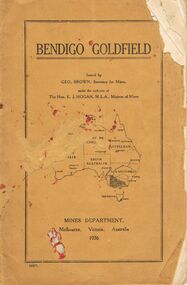
Book - JOAN O'SHEA COLLECTION: BENDIGO GOLDFIELD BOOK, 1936
Joan O'Shea collection. Buff coloured book issued by Mines Department Melbourne. Victoria Australia 1936. Information contained within refers to History, Recent developments and future Prospects, Geology, Lines of Reef for the Bendigo area, information regarding tonnage of gold and values of same at that time. The index at the rear of the book lists all of the mines in the Bendigo area.Geo. Brown, Secretary for Mines, Mines Departmentmining, business, mines department -
 Bendigo Historical Society Inc.
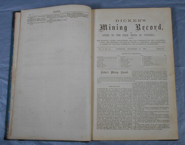
Journal - Dicker's Mining Journal 1862
Thomas Dicker, Rowan Street, Bendigo, published a monthly mining journal that included geological information, mine details and mining practises for particular mining districts. In 1868/9, Dicker moved to England to open the "Australian and London Mining Agency" with the goals of promoting investment in Victorian mines, entering Victorian mining shares on the London Stock market, and exploring the latest in mining technology that might be suitable for mining in Victoria.Dicker's Mining Record and guide to the gold mines of Victoria, showing the bearings, depths, thickness, dips and underlies of the auriferous lodes; the progress and cost of works in operation; containing also a variety of valuable interesting and statistical information. Published by the proprietor, Thomas Dicker, Rowan Street Sandhurst. A green with black spine hardcover book. Paper glued on the front with the title Dicker's Mining Journal 1862. On the spine in gold lettering Dicker's Mining Record Vol.1 1861-2. The book contains 12 issues of the Dicker's Mining Record, the first from Saturday, November 23, 1861: the last from October 24, 1862. Also, there are two pieces of paper inside front cover with writing in pencil; the first says: shaft originally No.3 shaft of the speedwell coy. in 1902 the North Normanby Coy. was formed and took over the shaft. A new winding engine was installed in 1909. 10 head battery 1905, extra 20 head in 1909. The second, also in pencil, reads: Dept. of Mines Geological survey No.4 Ballarat East goldfields - 1907 - Mr. Marbrey (?) 39 Shamrock St. Bendigo.Sticker on inside front page: Ballarat Historical Museum presented by Mr. W.H. Lewis Young Street. On second page in pencil: Mr. John N Bailey mining manager of John Woods mines Stawell, Sons of Freedom Beaufort (illegible). To Mr. John Bailey as a mark of esteem grom J. Logan.dicker's mining journal, 1862, mining -
 Kew Historical Society Inc
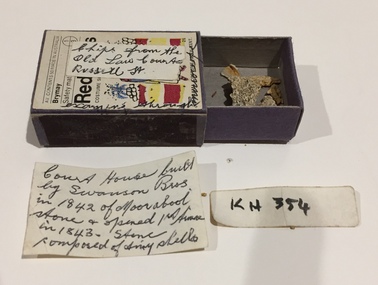
Geological specimen, Stone Chips From Old Law Courts, Russell Street (Melb), 1974
The law court buildings on the corner of Russell and La Trobe Streets (Melbourne) were later to house the Supreme Court of Victoria. The law courts were built in 1842. The inscription by Dorothy Rogers [sic] incorrectly describes the builders as Swanson Bros., who instead were the builders of the later Magistrates Court on the same site. Matchbox containing architectural fragments from the old law courts [Supreme Court] in Russell Street. The matchbox has a label on the front and more detailed information included in a note inside the box. The item is believed to have belonged to the historian Dorothy Rogers.Exterior "Chips from the old law courts Russell St." Inside: "Court House built by Swanson Bros in 1842 of Moorabool Stone & opened 1st time [sic] in 1843. Stone composed of tiny shells".dorothy rogers collection, supreme court - melbourne (vic), supreme court of victoria - russell street - melbourne (vic) -
Kew Historical Society Inc
Archive (Sub-series) - Subject File, Kew Historical Society, Geology (Kew), 1958
... . These include a Parks Victoria brochure on the Geology of Yarra Bend... a Parks Victoria brochure on the Geology of Yarra Bend Park ...Various partiesReference, Research, InformationSecondary Values (KHS Imposed Order)Subject file containing some secondary sources. These include a Parks Victoria brochure on the Geology of Yarra Bend Park and a printout of a web page about the Collingwood Children’s Farm that includes information about the geological formation of the region.kew historical society - archives, geology - kew (vic)kew historical society - archives, geology - kew (vic) -
Kew Historical Society Inc
Journal, The Kewriosity Sheet Vol.3 No.9 : April 1982
Kew Baptist Church expands youth ministry / p1. Family and Community Services programme [F.A.C.S.] / p1. Kew Lioness Club / p1. Easter Day sunrise service / p2. Kew Philharmonic Orchestra [programme] / p2. What's doing in Kew for April / p2&3. Ballroom dancing in Kew cha-cha-cha [Bernardo's Dance Studio] / p3. The Copy Shop / p3. Scrabble / p3. Hyde Park Fellowship [Hyde Park Uniting Church] / p3. Kew Garden Club / p3. Very ancient history [geology] / Barbara Giles p4. Native Plant Group / p4. They help their fellow citizens [Citizens Advice Bureau] / p4. Kew Chess Club / p4.The Kewriosity Sheet (1979-83) was first published in the City of Kew (Victoria) in June 1979 as a two-sided 'community newssheet'. It aimed to: 'share news about Kew happenings and Kew people, and to exchange ideas about living in Kew'. Later issues gradually evolved into a 4-page, quarto sized publication. The Kewriosity Sheet was superseded by the Kew Council publication 'Kewriosity' (1983-1994).non-fictionKew Baptist Church expands youth ministry / p1. Family and Community Services programme [F.A.C.S.] / p1. Kew Lioness Club / p1. Easter Day sunrise service / p2. Kew Philharmonic Orchestra [programme] / p2. What's doing in Kew for April / p2&3. Ballroom dancing in Kew cha-cha-cha [Bernardo's Dance Studio] / p3. The Copy Shop / p3. Scrabble / p3. Hyde Park Fellowship [Hyde Park Uniting Church] / p3. Kew Garden Club / p3. Very ancient history [geology] / Barbara Giles p4. Native Plant Group / p4. They help their fellow citizens [Citizens Advice Bureau] / p4. Kew Chess Club / p4. community publications --- kew (vic.), the kewriosity sheet, newsletters - kew (vic.) -
 Kew Historical Society Inc
Photograph - Yarra River, Studley Park, 1924
Henry Beater Christian (1886-1962) , was a descendant of one of the earliest settler families in Kew. Employed at the Kew Asylum as a 'public servant', he was a skilled amateur photographer, photographing numerous scenes in Kew and on his travels around Victoria. The majority of his photographs date from 1916 to 1929. His finest photographs are housed in two photograph albums. Digital copy of a photograph from page 7 of the 47-page photograph album containing 261 gelatinous silver images, loaned by Diane Washfold with permission given to digitise and hold a copy in our collection. This photograph reveals the cliffs and the remnant bush in 1924."Studley Park / Kew"henry beater christian (1886-1962), landscape photography, kew (vic.) — yarra river, christian-washfold collection, photograph albums, yarra river -- geology, studley park -
 Bendigo Tramways (managed by the Bendigo Heritage Attractions)
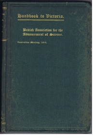
Reference Book, Albert J. Mullett, Government Printer, Melbourne, Handbook to Victoria- British Association for the Advancement of Science, CIRCA 1914
1914 Handbook prepared for the members of the "British Association for the advancement of science" on the occasion of their visit to Victoria, under the direction of the Victorian Executive Committee. Hard covered green handbook, gold leaf lettering. Printed text with Illustrations, Maps, Plans and Diagrams.Stamped: "WITH THE COMPLEMENTS OF THE GOVERNMENT STATIST." victoria, 1914, education, population, immigration, mining, geology, land, law, government, forestry, maps, public works. -
 Sunbury Family History and Heritage Society Inc.
Photograph, Bulla Primary School, Hanging Rock, 1995
In 1995, the upper school students from Bulla Primary School attended a camp at Hanging Rock Reserve which is part of the Macedon Ranges. At this camp the students were shown basic rock climbing skills and explored the rock for its interesting geological formations. Hanging Rock, also known as Mount Diogenes, is the traditional land of the Dja Dja Wurrung, Woi Wurrung and Taungurung people. It is a mamelon formed when magma poured from a vent and congealed. There are interesting rock functions at the site such as the Colonnade, the Eagle and the UFO. The highest point on the rock is 718metres above sea level and 105 meters above the land at its base.Hanging Rock is an important geological and volcanic structure in the Macedon Ranges area and in central Victoria. A non-digital coloured photograph of three holiday cabins and a barbecue in a bushland setting. A red car is parked outside one of the cabins as well as two permanent picnic tables.hanging rock, mount diogenes, mamelons, volcanoes, school camps, bulla primary school -
Stawell Historical Society Inc
Archive, Geological Survey of Victoria 1903 Brown Cover, 1903
... grampians Stawell Mining 1903 Brown Cover Geological Survey ...1903 Brown Coverstawell, mining -
University of Melbourne, Burnley Campus Archives
Map (item) - Geological map, Geological map of Melbourne & suburbs. Issued by the Department of Mines, Victoria, 1937
... by the Department of Mines, Victoria, 1937 Map Geological map ... -
 Port Fairy Historical Society Museum and Archives
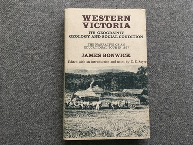
Book, James Bonwick, Western Victoria It’s geography geology and social condition. The Narrative of an Educational Tour in 1857
... Western Victoria It’s geography geology and social... and Yambuk. Les Robertson Western Victoria It’s geography geology ...1857 tour of Western Victoria including Tower Hill, Belfast and Yambuk.non-fiction1857 tour of Western Victoria including Tower Hill, Belfast and Yambuk.colonial education, belfast, victoria 1857, book -
Tarnagulla History Archive
Bulletins of the Geological Survey of Victoria, no. 5 Dunolly Goldfield, 1903
... . Bulletins of the Geological Survey of Victoria, no. 5 Dunolly ...David Gordon Collection. -
Tarnagulla History Archive
Bulletins of the Geological Survey of Victoria, no. 17 the Newbridge Goldfield, 1905
... . Bulletins of the Geological Survey of Victoria, no. 17 the Newbridge ...David Gordon Collection. -
Tarnagulla History Archive
Bulletins of the Geological Survey of Victoria, no. 17 the Newbridge Goldfield, 1905
... . Bulletins of the Geological Survey of Victoria, no. 17 the Newbridge ...David Gordon Collection. -
Tarnagulla History Archive
Records of the Geological Survey of Victoria, Vol. 3, Part 1, 1909
... of the Geological Survey of Victoria, Vol. 3, Part 1. Stokes & Son ...David Gordon Collection. -
Tarnagulla History Archive
Records of the Geological Survey of Victoria, Vol. 3, Part 1, 1909
... of the Geological Survey of Victoria, Vol. 3, Part 1. Stokes & Son ...David Gordon Collection.