Showing 3378 items matching "glenferrie"
-
 Melbourne Tram Museum
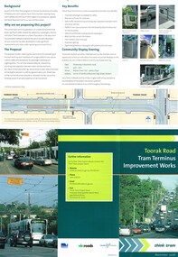
Pamphlet, Yarra Trams, "Toorak Road Tram Terminus Improvement Works", Nov. 2006
Pamphlet, folded to DL size, printed on full gloss paper titled "Toorak Road Tram Terminus Improvement Works", dated Nov. 2006 and part of the "Think Tram" project outlining the redevelopment proposals of the Toorak Road terminus. Shows the track plan and proposed stop, along with the curve into Glenferrie Road. Gives details of the proposal and consultative meetings. Gives details of the VicRoads think tram project contacts. Two copies held. The proposal did not proceed. Another proposal was prepared for Feb. 2015 and was not well received by the City of Stonington. See the local Leader dated 19/2/2015. Work to rebuild the tram stop planned by a Yarra Trams notice of 19-11-2015 to be undertake work at the intersection between 16-11-15 and 3-12-15.trams, tramways, yarra trams, toorak rd, route 8, superstops -
 Melbourne Tram Museum
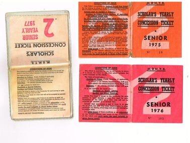
Ephemera - Ticket/s, Melbourne & Metropolitan Tramways Board (MMTB), "Scholar's Yearly Concession Ticket", 1975 to 1977
Set of two clothed backed paper tickets, printed as a MMTB "Scholar's Yearly Concession Ticket", for Seniors and one paper ticket contained within a plastic envelope. Gives condition of use on the outside cover. Each issue to Roderick Atkins. Each lists the various terms for which they were available and available from Cotham and Glenferrie Road, to Callantinia Road, Scotch College. Two sections. .1 - Orange cloth, Senior 1975, cost not shown No. 18 .2 - red cloth, Senior 1976, cost $39.00 No. 203 issued at Doncaster Depot .3 - light yellow paper within a plastic envelope, Senior 1976, cost $39, No. 42583, issued at Kew Depot. See Reg Item 5571 for other examples of item 3trams, tramways, mmtb, tickets, schools, schools tickets, scholar's tickets -
 Vision Australia
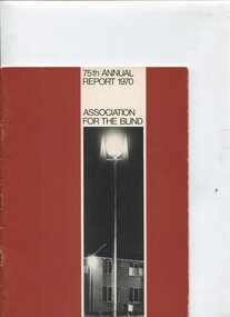
Administrative record - Text, 75th Annual Report 1970 Association for the Blind of Victoria, 1971
Articles in annual report include: branch committees, President's report, finance report, balance sheet, hospital homes, blind citizens community centre, welfare, auxiliaries, senior staff, life governors, historical and current photographs of Ballarat, Bendigo, Brighton and the Blind Citizens Community centre, establishment of an ophthalmological clinic at Elanora, demand for more nursing beds and funding for nursing support, need for hostel accommodation for short stay or respite for carers, renaming of Brighton Blind Home to Elanora, 20 bed nursing wing to be opened at Mirridong next year, a second block of flats facing Glenferrie Road has been purchased due to demand for expansion at Kooyong Blind Citizens Community Centre, plan for a memorial garden with a sensory section in front of the club house, appointment of a hairdresser at Kooyong and two holidays at Cumberland House in Lorne have been organised and were a huge success1 volume of text and photographsassociation for the blind, elanora home (brighton), mirridong home (bendigo), kelaston home (ballarat), annual reports -
 Uniting Church Archives - Synod of Victoria
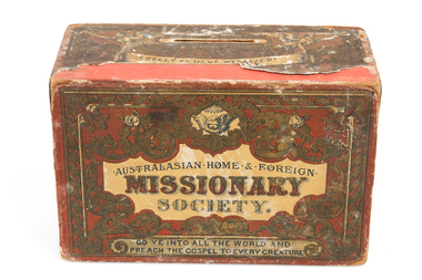
Giving Box, Australasian Home & Foreign Missionary Society giving box, ? Late 19th Century
Wooden giving box with paper labelsTop: "freely Ye Have Received! xxx [illegible] Give". Front: "Australasian Home & Foreign Missionary Society : Go ye into all the world and preach the Gospel to every creature". Side 1: "He shall speak peace unto the Heathen". Side 2: "The Idols he shall utterly Abolish". Back: " This Box should be opened and the Money sent to Rev. B. Danks, Glenferrie Road, Kew, not later than the end of January in each year B.D."australasian home & foreign missionary -
 Vision Australia
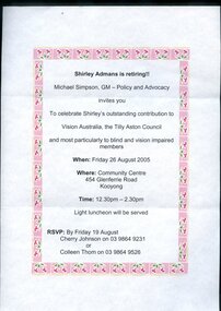
Letter - Text, Invitation to Shirley Adman's retirement function, 2005
Letter advising that Shirley Admans is retiring and a function will be held to celebrate her outstanding contribution to the Tilly Aston Council, members and the organisation.A4 page with printed border and writingnon-fictionShirley Admans is retiring! Michael Simpson, GM - Policy and Advocacy invites you To celebrate Shirley's outstanding contribution to Vision Australia, the Tilly Aston Council and most particularly to blind and vision impaired members When: Friday 26 August 2005 Where: Community Centre 454 Glenferrie Road Kooyong Time: 12.30pm-2.30pm Light luncheon will be served RSVP: By Friday 19 August Cherry Johnson on 03 9864 9231 or Colleen Thom on 03 9864 9526 vision australia foundation, shirley admans -
 Port Melbourne Historical & Preservation Society
Document - Victorian Railway tickets, c. 1960' & 70's
From the collection of Warren DOUBLEDAY. Tickets were given to donor by retired railway officials who were given access to them for their collections following the tickets withdrawal from use. Fifteen are for journeys to and from the Port Melbourne station and include Single, Weekly and 'Extended Periodical' tickets.Those from Graham Street Station include three singles & one 'Periodical Pass'. As well as the singles & weekly tickets, the 24 to & from North Port Station also include a 'Periodical Pass' and one for a 'Collapsible Pram'. . From Montague Station single and weekly journeys make up the eight tickets. The weekly tickets show how far people would travel to work in Port Melbourne. From Ascot Vale, Broadmeadows, Carrum, Coburg, Gowrie, Malvern, Mont Albert, Reservoir, St Albans, Thorrnbury, Williamstown, Yarramam. Single tickets are for travel to or from Auburn, Clayton, Collingwood, Glenferrie, Hawthorn, Kensington, Melbourne, Mont Albert, Moonee Ponds, Richmond, West Footscray, A collection of 51 undated railway tickets.transport - railways, north port station, graham station, montague station, port melbourne station -
 Kew Historical Society Inc
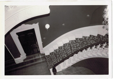
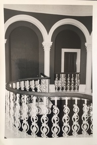
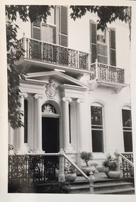
Photograph - 'Butleigh Wooton', 867 Glenferrie Road, John T Collins, 1979
in 1882 Thomas Maidment paid the Society of Jesus £5,750 for nine allotments along Barkly Road (now Glenferrie Road). Maidment, who had arrived in Australia from the Glastonbury district in England in 1858, owned and managed a number of sheep stations in Victoria and subsequently became an '... eminently respectable ...' member of District society. In 1883 the Rate Books list Maidment's land in Barkly Road as the 'Buxton Hill Estate' and it was given an N.A.V. of £90, while in the following year his property attracted an N.A.V. of £160, suggesting that substantial improvements were taking place. Maidment's two-storey mansion, named 'Butleigh Wooton' after his birth-place in England, was completed in 1885 and was given an initial N.A.V. of £420. While Maidrnent is recorded as the owner of the building until at least 1896, Jane Maidment, his wife, continued the family ownership of the twenty-six roomed house with its extensive grounds until at least 1910. (Sanderson P. City of Kew Urban Conservation Study Vol 2)Butleigh Wooton is a substantial two storeyed house built in the Italianate style common in the 1880s. Its walls are rendered and it has limited applied decoration that includes brackets to the eaves line and engaged ionic columns under a broken pediment over the front entrance. The bowed window unit is of particular distinction and is not at all typical of this type of building. This interior by John T Collins is a view of the staircase from the first floor landing. (Sanderson P. City of Kew Urban Conservation Study Vol 2)Reverse: "JOHN COLLINS / 11 Anderson Road / Hawthorn East, 3123 / Film 395 Exposure 27A / Kew / Butleigh Wooton / Looking down on stairs / 8-4-79thomas maidment, butleigh wooton, 867 glenferrie road -- kew (vic.) -
 Kew Historical Society Inc
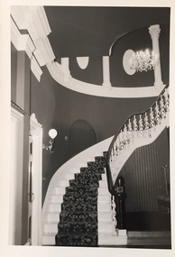
Photograph - 'Butleigh Wooton', 867 Glenferrie Road, John T Collins, 1979
in 1882 Thomas Maidment paid the Society of Jesus £5,750 for nine allotments along Barkly Road (now Glenferrie Road). Maidment, who had arrived in Australia from the Glastonbury district in England in 1858, owned and managed a number of sheep stations in Victoria and subsequently became an '... eminently respectable ...' member of District society. In 1883 the Rate Books list Maidment's land in Barkly Road as the 'Buxton Hill Estate' and it was given an N.A.V. of £90, while in the following year his property attracted an N.A.V. of £160, suggesting that substantial improvements were taking place. Maidment's two-storey mansion, named 'Butleigh Wooton' after his birth-place in England, was completed in 1885 and was given an initial N.A.V. of £420. While Maidrnent is recorded as the owner of the building until at least 1896, Jane Maidment, his wife, continued the family ownership of the twenty-six roomed house with its extensive grounds until at least 1910. (Sanderson P. City of Kew Urban Conservation Study Vol 2)Butleigh Wooton is a substantial two storeyed house built in the Italianate style common in the 1880s. Its walls are rendered and it has limited applied decoration that includes brackets to the eaves line and engaged ionic columns under a broken pediment over the front entrance. The bowed window unit is of particular distinction and is not at all typical of this type of building. This interior by John T Collins is a view of the staircase from the first floor landing. (Sanderson P. City of Kew Urban Conservation Study Vol 2)Reverse: "JOHN COLLINS / 11 Anderson Road / Hawthorn East, 3123 / Film 395 Exposure 21A / Kew / Butleigh Wooton / Staircase / 8-4-79thomas maidment, butleigh wooton, 867 glenferrie road -- kew (vic.), john t collins -
 Kew Historical Society Inc
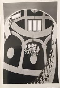
Photograph - 'Butleigh Wooton', 867 Glenferrie Road, John T Collins, 1979
in 1882 Thomas Maidment paid the Society of Jesus £5,750 for nine allotments along Barkly Road (now Glenferrie Road). Maidment, who had arrived in Australia from the Glastonbury district in England in 1858, owned and managed a number of sheep stations in Victoria and subsequently became an '... eminently respectable ...' member of District society. In 1883 the Rate Books list Maidment's land in Barkly Road as the 'Buxton Hill Estate' and it was given an N.A.V. of £90, while in the following year his property attracted an N.A.V. of £160, suggesting that substantial improvements were taking place. Maidment's two-storey mansion, named 'Butleigh Wooton' after his birth-place in England, was completed in 1885 and was given an initial N.A.V. of £420. While Maidrnent is recorded as the owner of the building until at least 1896, Jane Maidment, his wife, continued the family ownership of the twenty-six roomed house with its extensive grounds until at least 1910. (Sanderson P. City of Kew Urban Conservation Study Vol 2)Butleigh Wooton is a substantial two storeyed house built in the Italianate style common in the 1880s. Its walls are rendered and it has limited applied decoration that includes brackets to the eaves line and engaged ionic columns under a broken pediment over the front entrance. The bowed window unit is of particular distinction and is not at all typical of this type of building. This interior by John T Collins is a view of the staircase from the first floor landing. (Sanderson P. City of Kew Urban Conservation Study Vol 2)Reverse: "JOHN COLLINS / 11 Anderson Road / Hawthorn East, 3123 / Film 395 Exposure 21A / Kew / Butleigh Wooton / Staircase looking up to dome / 8-4-79thomas maidment, butleigh wooton, 867 glenferrie road -- kew (vic.), john t collins -
 Kew Historical Society Inc
Photograph - 'Butleigh Wooton', 867 Glenferrie Road, John T Collins, 1979
in 1882 Thomas Maidment paid the Society of Jesus £5,750 for nine allotments along Barkly Road (now Glenferrie Road). Maidment, who had arrived in Australia from the Glastonbury district in England in 1858, owned and managed a number of sheep stations in Victoria and subsequently became an '... eminently respectable ...' member of District society. In 1883 the Rate Books list Maidment's land in Barkly Road as the 'Buxton Hill Estate' and it was given an N.A.V. of £90, while in the following year his property attracted an N.A.V. of £160, suggesting that substantial improvements were taking place. Maidment's two-storey mansion, named 'Butleigh Wooton' after his birth-place in England, was completed in 1885 and was given an initial N.A.V. of £420. While Maidrnent is recorded as the owner of the building until at least 1896, Jane Maidment, his wife, continued the family ownership of the twenty-six roomed house with its extensive grounds until at least 1910. (Sanderson P. City of Kew Urban Conservation Study Vol 2)Butleigh Wooton is a substantial two storeyed house built in the Italianate style common in the 1880s. Its walls are rendered and it has limited applied decoration that includes brackets to the eaves line and engaged ionic columns under a broken pediment over the front entrance. The bowed window unit is of particular distinction and is not at all typical of this type of building. This interior by John T Collins is a view of the staircase from the first floor landing. (Sanderson P. City of Kew Urban Conservation Study Vol 2)Reverse: "JOHN COLLINS / 11 Anderson Road / Hawthorn East, 3123 / Film 395 Exposure 21A / Kew / Butleigh Wooton / Railing at head of stairs / 8-4-79thomas maidment, butleigh wooton, 867 glenferrie road -- kew (vic.), john t collins -
 Kew Historical Society Inc
Photograph - 'Butleigh Wooton', 867 Glenferrie Road, John T Collins, 1979
in 1882 Thomas Maidment paid the Society of Jesus £5,750 for nine allotments along Barkly Road (now Glenferrie Road). Maidment, who had arrived in Australia from the Glastonbury district in England in 1858, owned and managed a number of sheep stations in Victoria and subsequently became an '... eminently respectable ...' member of District society. In 1883 the Rate Books list Maidment's land in Barkly Road as the 'Buxton Hill Estate' and it was given an N.A.V. of £90, while in the following year his property attracted an N.A.V. of £160, suggesting that substantial improvements were taking place. Maidment's two-storey mansion, named 'Butleigh Wooton' after his birth-place in England, was completed in 1885 and was given an initial N.A.V. of £420. While Maidrnent is recorded as the owner of the building until at least 1896, Jane Maidment, his wife, continued the family ownership of the twenty-six roomed house with its extensive grounds until at least 1910. (Sanderson P. City of Kew Urban Conservation Study Vol 2)Butleigh Wooton is a substantial two storeyed house built in the Italianate style common in the 1880s. Its walls are rendered and it has limited applied decoration that includes brackets to the eaves line and engaged ionic columns under a broken pediment over the front entrance. The bowed window unit is of particular distinction and is not at all typical of this type of building. This interior by John T Collins is a view of the staircase from the first floor landing. (Sanderson P. City of Kew Urban Conservation Study Vol 2)Reverse: "JOHN COLLINS / 11 Anderson Road / Hawthorn East, 3123 / Film 395 Exposure 21A / Kew / Butleigh Wooton / Entrance / 8-4-79thomas maidment, butleigh wooton, 867 glenferrie road -- kew (vic.), john t collins -
 Kew Historical Society Inc
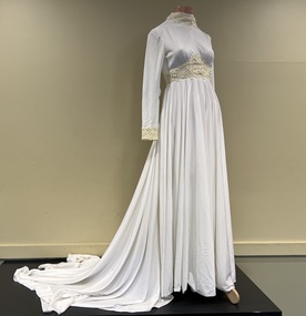
Clothing - Wedding dress, The House of Franke, Stuart, c.1975
At 5pm on 2 May 1975 at Christ Church, Hawthorn, the wedding took place between Kathryn Gwynn Marx of Mason Street, Hawthorn, and William Peter Reeve of Mountain Grove, Kew. The bride's dress was purchased from the 'House of Franke, Stuart', 612 Glenferrie Road, Hawthorn, a very popular place in the 1970s for brides. Kathryn was educated at Ruyton Girls' School with Margaret Franke so it was a nice connection. Margaret's family business had been in operation since 1926. I loved my wedding dress. It was soft and comfortable to wear and kept me warm on the May evening. It was elegant and I knew I would never get the chance to wear something with a long train again. Walking down the staircase at the Windsor Hotel in Melbourne felt very grand; a memory I still hold today. (Kate Reeve, 2022) [Note: Two photos and a newspaper article which are viewable in the image carousel are held in the donation file]Strong local provenance to Hawthorn, Kew and Boroondara due to owner and retailer. It is a representative example of wedding dresses sold in the 1970s. The wedding dress is made of fine soft white jersey with guipure lace around the neckline, wrists and bodice. The long train has three small discreet loops along the hemline which can be slipped onto a finger for a draped effect giving ease of movement for dancing etc. A satin trimmed veil covered the length of the train and was secured on the head with a satin coronet. White leather shoes were worn. The bouquet Phalaenopsis orchids. (Note: the veil and shoes were not part of the donation)Label: Franke Stuart / Hawthornfashion & design - 1970s, wedding dresses, kate reeve, peter reeve, franke stuart, retailers - glenferrie road - hawthorn (vic.) -
 Whitehorse Historical Society Inc.
Article, Why Is It So?
How the eastern suburbs were named.ashburton, ashwood, ballyshanassy, balwyn, blackburn, black flat, box hill, burwood, camberwell, canterbury, deepdene, forest hill, glenferrie, glen iris, glen waverley, hawthorn, mont albert, mount waverley, nunawading, riversdale, surrey hill, vermont, wattle park -
 Kew Historical Society Inc
Plan, Melbourne & Metropolitan Board of Works : Borough of Kew : Detail Plan No.1575, 1905
The Melbourne and Metropolitan Board of Works (MMBW) plans were produced from the 1890s to the 1950s. They were crucial to the design and development of Melbourne's sewerage and drainage system. The plans, at a scale of 40 feet to 1 inch (1:480), provide a detailed historical record of Melbourne streetscapes and environmental features. Each plan covers one or two street blocks (roughly six streets), showing details of buildings, including garden layouts and ownership boundaries, and features such as laneways, drains, bridges, parks, municipal boundaries and other prominent landmarks as they existed at the time each plan was produced. (Source: State Library of Victoria)This plan forms part of a large group of MMBW plans and maps that was donated to the Society by the Mr Poulter, City Engineer of the City of Kew in 1989. Within this collection, thirty-five hand-coloured plans, backed with linen, are of statewide significance as they include annotations that provide details of construction materials used in buildings in the first decade of the 20th century as well as additional information about land ownership and usage. The copies in the Public Record Office Victoria and the State Library of Victoria are monochrome versions which do not denote building materials so that the maps in this collection are invaluable and unique tools for researchers and heritage consultants. A number of the plans are not held in the collection of the State Library of Victoria so they have the additional attribute of rarity.Original survey plan, issued by the MMBW to a contractor with responsibility for constructing sewers in the area identified on the plan within the Borough of Kew. The plan was at some stage hand-coloured, possibly by the contractor, but more likely by officers working in the Engineering Department of the Borough and later Town, then City of Kew. The hand-coloured sections of buildings on the plan were used to denote masonry or brick constructions (pink), weatherboard constructions (yellow), and public buildings (grey). Plan No.1575 shows that in the area bounded by Wellington Street, Edgevale Road, Glenferrie Road, and Cotham Road, there had already been significant subdivision of land and houses constructed. As one of the highest points in Kew, as expected, there were already some significant mansions built on large allotments of land. Many of these mansions are identified by name on the plan such as ‘Kelso’, ‘Abbotsford’, ‘Clarendon’ and ‘Ashlyn’ in Cotham Road. Other houses of equal size are unnamed on the plan.melbourne and metropolitan board of works, detail plans, maps - borough of kew, mmbw 1575, cartography -
 Kew Historical Society Inc
Functional object - Wrought iron nails from 'Reno', St John's Parade, c. 1864
Comparatively few weatherboard houses in Kew survived from the early years of settlement into the second half of the 20th century. One such property was ‘Reno’, which once stood on the east side of St John’s Parade. Its earliest recorded owner was the architect Samuel Cocking who lived there from c.1865 until his death in 1888. The original landholding was bordered by Cotham Road, Glenferrie Road, Wellington Street, and Charles Street. The southern portion of this land included a fine orchard, with many imported trees. The old summer house, at first in the orchard, was later removed to the house garden. The MMBW Detail Plan No.1576 (1904) shows the remaining portion of the original land holding, including a semi-circular pathway at the front, and garden features such as an aviary, a fountain and grotto, and a fernery. None of these are apparent in photographs dating from the 1960s, where the garden, which once included rare plants provided by Baron Von Mueller, surrounds the cottage in a tangled frenzy. Despite a ‘local significance’ classification by the National Trust, the house was demolished in 1977.7 square headed iron nails collected from Reno before its demolition. In envelope marked with the name Joy Stewartreno, nails, samuel cocking -
![Wallpaper from 'Reno', St John's Parade [Kew]](/media/collectors/550653872162f11fb04854aa/items/57975996d0cdd1098c81d980/item-media/579759ded0cdd1098c81f6fa/item-fit-380x285.jpg) Kew Historical Society Inc
Kew Historical Society IncDecorative object - Wallpaper sample from 'Reno', St John's Parade, 1890s
Comparatively few weatherboard houses in Kew survived from the early years of settlement into the second half of the 20th century. One such property was ‘Reno’, which once stood on the east side of St John’s Parade. Its earliest recorded owner was the architect Samuel Cocking who lived there from c.1865 until his death in 1888. The original landholding was bordered by Cotham Road, Glenferrie Road, Wellington Street, and Charles Street. The southern portion of this land included a fine orchard, with many imported trees. The old summer house, at first in the orchard, was later removed to the house garden. The MMBW Detail Plan No.1576 (1904) shows the remaining portion of the original land holding, including a semi-circular pathway at the front, and garden features such as an aviary, a fountain and grotto, and a fernery. None of these are apparent in photographs dating from the 1960s, where the garden, which once included rare plants provided by Baron Von Mueller, surrounds the cottage in a tangled frenzy. Despite a ‘local significance’ classification by the National Trust, the house was demolished in 1977. Wallpaper fragment from ‘Reno’. This small fragment of floral wall paper is a bolder design than the delicately drawn flowers in 1977.0005.1. The flowers in this example were impressionistically created using printing blocks that allowed for different thicknesses of paint to be applied in the hand-blocking process. wallpaper, reno, st john's parade, kew -
![Wallpaper from 'Reno', St John's Parade [Kew]](/media/collectors/550653872162f11fb04854aa/items/57975a62d0cdd1098c8232a8/item-media/57975cabd0cdd1098c836f91/item-fit-380x285.jpg) Kew Historical Society Inc
Kew Historical Society IncDecorative object - Wallpaper sample from 'Reno', St John's Parade, 1870s
Comparatively few weatherboard houses in Kew survived from the early years of settlement into the second half of the 20th century. One such property was ‘Reno’, which once stood on the east side of St John’s Parade. Its earliest recorded owner was the architect Samuel Cocking who lived there from c.1865 until his death in 1888. The original landholding was bordered by Cotham Road, Glenferrie Road, Wellington Street, and Charles Street. The southern portion of this land included a fine orchard, with many imported trees. The old summer house, at first in the orchard, was later removed to the house garden. The MMBW Detail Plan No.1576 (1904) shows the remaining portion of the original land holding, including a semi-circular pathway at the front, and garden features such as an aviary, a fountain and grotto, and a fernery. None of these are apparent in photographs dating from the 1960s, where the garden, which once included rare plants provided by Baron Von Mueller, surrounds the cottage in a tangled frenzy. Despite a ‘local significance’ classification by the National Trust, the house was demolished in 1977.Wallpaper fragment from ‘Reno’. This large single example is interesting as it represents a change in fashion and style from the finely drawn flowers (1971.0002.1) of an older paper, parts of which can be seen behind this sample. Typically the updating of wallpapers was accomplished by laying a new paper over the old. The ‘newer’ wallpaper is of a single colour, the tone of which may have suffered from colour distortion due to ageing. The new block-printed design, featuring repeated sprays of flowers and leaves combines a bold use of colour with an elegance of design.reno, st john's parade, kew, samuel cocking, wallpaper -
![Wallpaper fragment - Reno, St John's Parade [Kew]](/media/collectors/550653872162f11fb04854aa/items/57975cd6d0cdd1098c838ddb/item-media/57975d42d0cdd1098c83c222/item-fit-380x285.jpg) Kew Historical Society Inc
Kew Historical Society IncDecorative object - Wallpaper sample from 'Reno', St John's Parade, 1870s
Comparatively few weatherboard houses in Kew survived from the early years of settlement into the second half of the 20th century. One such property was ‘Reno’, which once stood on the east side of St John’s Parade. Its earliest recorded owner was the architect Samuel Cocking who lived there from c.1865 until his death in 1888. The original landholding was bordered by Cotham Road, Glenferrie Road, Wellington Street, and Charles Street. The southern portion of this land included a fine orchard, with many imported trees. The old summer house, at first in the orchard, was later removed to the house garden. The MMBW Detail Plan No.1576 (1904) shows the remaining portion of the original land holding, including a semi-circular pathway at the front, and garden features such as an aviary, a fountain and grotto, and a fernery. None of these are apparent in photographs dating from the 1960s, where the garden, which once included rare plants provided by Baron Von Mueller, surrounds the cottage in a tangled frenzy. Despite a ‘local significance’ classification by the National Trust, the house was demolished in 1977. Wallpaper fragment from ‘Reno’. These three boldly designed samples from a single room are in shades of green and brown, highlighted by yellow and red floral sprays. While more accurately printed and coloured, the fragment lacks the freedom of design of the earlier samples.wallpaper, reno, st john's parade, kew, samuel cocking -
![Reno, St John's Parade [Kew] - Reno, St John's Parade [Kew]](/media/collectors/550653872162f11fb04854aa/items/57975dcbd0cdd1098c840aaf/item-media/57975e31d0cdd1098c84343d/item-fit-380x285.jpg) Kew Historical Society Inc
Kew Historical Society IncDecorative object - Wallpaper samples from 'Reno', St John's Parade, 1880-1910
Comparatively few weatherboard houses in Kew survived from the early years of settlement into the second half of the 20th century. One such property was ‘Reno’, which once stood on the east side of St John’s Parade. Its earliest recorded owner was the architect Samuel Cocking who lived there from c.1865 until his death in 1888. The original landholding was bordered by Cotham Road, Glenferrie Road, Wellington Street, and Charles Street. The southern portion of this land included a fine orchard, with many imported trees. The old summer house, at first in the orchard, was later removed to the house garden. The MMBW Detail Plan No.1576 (1904) shows the remaining portion of the original land holding, including a semi-circular pathway at the front, and garden features such as an aviary, a fountain and grotto, and a fernery. None of these are apparent in photographs dating from the 1960s, where the garden, which once included rare plants provided by Baron Von Mueller, surrounds the cottage in a tangled frenzy. Despite a ‘local significance’ classification by the National Trust, the house was demolished in 1977.Wallpaper fragment from ‘Reno’. These two large fragments of wallpaper have a formality of design that is accentuated by the wide borders and narrow vertical lines that separate the repeated designs of rose garlands in vases on a vertical trellis design. The design is in tones of pink and green with gilding.reno, st john's parade, kew, samuel cocking, wallpaper -
![Wallpaper from 'Reno', St John's Parade [Kew]](/media/collectors/550653872162f11fb04854aa/items/57975eabd0cdd1098c846619/item-media/57975ee7d0cdd1098c8484f7/item-fit-380x285.jpg) Kew Historical Society Inc
Kew Historical Society IncDecorative object - Wallpaper samples from 'Reno', St John's Parade, 1880-1914
Comparatively few weatherboard houses in Kew survived from the early years of settlement into the second half of the 20th century. One such property was ‘Reno’, which once stood on the east side of St John’s Parade. Its earliest recorded owner was the architect Samuel Cocking who lived there from c.1865 until his death in 1888. The original landholding was bordered by Cotham Road, Glenferrie Road, Wellington Street, and Charles Street. The southern portion of this land included a fine orchard, with many imported trees. The old summer house, at first in the orchard, was later removed to the house garden. The MMBW Detail Plan No.1576 (1904) shows the remaining portion of the original land holding, including a semi-circular pathway at the front, and garden features such as an aviary, a fountain and grotto, and a fernery. None of these are apparent in photographs dating from the 1960s, where the garden, which once included rare plants provided by Baron Von Mueller, surrounds the cottage in a tangled frenzy. Despite a ‘local significance’ classification by the National Trust, the house was demolished in 1977. Wallpaper fragment from ‘Reno’. This small fragment is part of the larger design shown in the previous sample (1971.0002.5). It includes a detail of the trellis element from the larger scheme.wallpaper, samuel cocking, reno, st john's parade, kew -
![Letter Plate, 'Reno', St John's Parade [Kew]](/media/collectors/550653872162f11fb04854aa/items/57a03863d0cdd1210435bac1/item-media/57a038b1d0cdd1210435f155/item-fit-380x285.jpg) Kew Historical Society Inc
Kew Historical Society IncFunctional object - Letter Plate, 'Reno', St John's Parade, c.1900
Comparatively few weatherboard houses in Kew survived from the early years of settlement into the second half of the 20th century. One such property was ‘Reno’, which once stood on the east side of St John’s Parade. Its earliest recorded owner was the architect Samuel Cocking who lived there from c.1865 until his death in 1888. The original landholding was bordered by Cotham Road, Glenferrie Road, Wellington Street, and Charles Street. The southern portion of this land included a fine orchard, with many imported trees. The old summer house, at first in the orchard, was later removed to the house garden. The MMBW Detail Plan No.1576 (1904) shows the remaining portion of the original land holding, including a semi-circular pathway at the front, and garden features such as an aviary, a fountain and grotto, and a fernery. None of these are apparent in photographs dating from the 1960s, where the garden, which once included rare plants provided by Baron Von Mueller, surrounds the cottage in a tangled frenzy. Despite a ‘local significance’ classification by the National Trust, the house was demolished in 1977.Brass letter plate, originally from the front door of Reno in St John's Parade, Kew. Donated by Miss McDowell in 1977, in the year the house was demolished.reno, st john's parade, kew -
![Wallpaper sample from 'Reno', St John's Parade [Kew]](/media/collectors/550653872162f11fb04854aa/items/5670dfde2162f10b54fac48a/item-media/5797600bd0cdd1098c854c29/item-fit-380x285.jpg) Kew Historical Society Inc
Kew Historical Society IncDecorative object - Wallpaper sample from 'Reno', St John's Parade, 1850-1880
Comparatively few weatherboard houses in Kew survived from the early years of settlement into the second half of the 20th century. One such property was ‘Reno’, which once stood on the east side of St John’s Parade. Its earliest recorded owner was the architect Samuel Cocking who lived there from c.1865 until his death in 1888. The original landholding was bordered by Cotham Road, Glenferrie Road, Wellington Street, and Charles Street. The southern portion of this land included a fine orchard, with many imported trees. The old summer house, at first in the orchard, was later removed to the house garden. The MMBW Detail Plan No.1576 (1904) shows the remaining portion of the original land holding, including a semi-circular pathway at the front, and garden features such as an aviary, a fountain and grotto, and a fernery. None of these are apparent in photographs dating from the 1960s, where the garden, which once included rare plants provided by Baron Von Mueller, surrounds the cottage in a tangled frenzy. Despite a ‘local significance’ classification by the National Trust, the house was demolished in 1977.Original sample of nineteenth century wallpaper from one of the earliest homes in Kew (Victoria).Wallpaper fragment from ‘Reno’. These two samples of light brown Victorian-period wallpaper were overprinted with flowers and leaves that are outlined in maroon. Flowers and foliage are painted in blue of varying intensity, giving the impression of being hand painted. The style of this wallpaper would have been suited to a bedroom or drawing room.wallpaper, samuel cocking, reno, st john's parade, kew -
 Vision Australia
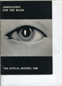
Administrative record - Text, 73rd Annual Report 1968 Association for the Blind of Victoria, 1969
Articles in annual report include: branch committees, President's report, finance report, balance sheet, hospital homes, community centre, welfare, volunteer service group, auxiliaries, life governors, guiding light appeal, Isadore Smith's bravery, Prime Minister Hon. J.G. Gorton opening the Ballarat section of the Guiding Light Appeal, Victorian Governor General Sir Rohan Delacombe the Bendigo section and Victorian Premier Sir Henry Bolte the Metropolitan section, Hubert Opperman being knighted in the Queen's Birthday honours, waiting list time for admission is 18 months - two years and are almost exclusively nursing cases as the peak for active aged recedes, erection of the two storey wing at Brighton thanks to grant from estate of the late Herbert Engelbert, the demolishing of the 100 year house at Brighton required for the extension, Mrs Laura Clarke - a resident of Mirridong - celebrated turning 102, and the need for additional room and accommodation for a resident caretaker has necessitated the purchase of a block of flats facing Glenferrie Road, with the assistance of the William Buckland Trust.16 pages of text and photographsassociation for the blind, isadore smith, e.a. soderstrom, miss tobias, annual reports -
![Uniform - School Uniform, Woodbury Ladies’ College [Kew] Badge, circa 1918, c.1918](/media/collectors/550653872162f11fb04854aa/items/5e89f58a21ea671a7c03d0c9/item-media/5e89f65821ea671a7c0508fc/item-fit-380x285.jpg) Kew Historical Society Inc
Kew Historical Society IncUniform - School Uniform, Woodbury Ladies’ College [Kew] Badge, circa 1918, c.1918
Woodbury College was an indirect predecessor of Preshil School in Kew. Woodbury College was founded in Glenferrie Road by a Miss Harcourt, former principal of Sydenham College, Moonee Ponds. Miss Harcourt maintained the school until the goodwill was purchased in 1908 by Miss LJ Macey, who had previously operated Lillsden Ladies' College in Edgevale Road, between c.1891 and c.1903. The first school was in a rented building on the south side of Cotham Road between Atkins and Davis Streets. In 1910, a new school building was built on the corner of Uvadale Grove and Cotham Road [the building is still extant as of 2020]. Woodbury College was operated by Miss LJ and Miss HJ Macey until 1920. In 1921, the school amalgamated with the newly formed St Andrew's College, Mont Victor Road, Kew (Vic) under the leadership of Rev JT Lawton [who had previously been principal of St Andrew's School of the 'Pathfinder' in South Yarra]. Miss Macey was for a period the Headmistress of the amalgamated school. Another teacher at the school was Miss Margaret JR Lyttle, who in 1931, left St Andrew's to form the Preshil School.Rare ephemera relating to an early private school in Kew (Vic). The badge was donated by Helen Lade.Brass school badge which includes the initials WL within a large C, surrounded with the school crest - VERITAS VINCIT [Truth Prevails] of Woodbury Ladies College (1903-1920). woodbury college, schools - cotham road - kew - vic, private schools - kew (vic) -
Kew Historical Society Inc
Archive (series) - Subject File, Kew Historical Society, Woodbury Ladies' College, 1986
Various partiesReference, Research, InformationSecondary Values (KHS Imposed Order)Subject file containing information about Woodbury College, Cotham Road, Kew (Vic). The file includes historically significant primary sources relating to the former Woodbury College [c.1898-1920] and Lillsden Ladies' College, Edgevale Road, Kew (Vic) [c.1891-1903]. In addition to manuscripts, the file also includes photographs and ephemera such as a metal school badge, a hatband and printed programs and school magazines. The file [as of 2020] includes materials donated between 1986 and 2005 by descendants of the second principal (Miss Macey), and by former students and or their descendants. The contents of the reference file include: 1. School origins : undated handwritten manuscript [2pp]; 2. Annual Reports : Handwritten manuscripts for the years 1908, 1909, 1910, 1912, 1913, 1914, 1916, 1917, 1919, 1920 by Miss LJ Macey; 3. Prize List : undated manuscript [3pp]; 4. School Magazine ; undated handwritten manuscripts about the origin of the school's magazine; 5. Woodbury Chat [school magazine] : printed booklets from the years 1918, 1919, 1920 x 2; 6. Correspondence [sundry] : handwritten letters from a parent [1916] and a former pupil (sic) [1938] to Miss Macey; 7. Exercise Books : one containing a handwritten history of the school(s) and the names and addresses of former students and teachers; and the other containing information relating to the National Home Reading Union, Kew Circle [1912-c.1916]. 8. Metal school badge and photographic negative of students. The names of various donors are listed in the file: they include Ann Ransom, Muriel Coghlan, Helen Lade, and Lilian McRae (nee Houston).woodbury college, misses macey, schools - kew (vic), schools - cotham road - kew - vic, private schools - kew (vic), rev jt lawton, cotham road - kew (vic.)woodbury college, misses macey, schools - kew (vic), schools - cotham road - kew - vic, private schools - kew (vic), rev jt lawton, cotham road - kew (vic.) -
![Uniform - School Uniform, Hatband of Woodbury Ladies’ College [Kew], circa 1918, c.1918](/media/collectors/550653872162f11fb04854aa/items/5e254add21ea671e18757914/item-media/5e254b2121ea671e1875b9aa/item-fit-380x285.jpg) Kew Historical Society Inc
Kew Historical Society IncUniform - School Uniform, Hatband of Woodbury Ladies’ College [Kew], circa 1918, c.1918
Woodbury College was an indirect predecessor of Preshil School in Kew. Woodbury College was founded in Glenferrie Road by a Miss Harcourt, former principal of Sydenham College, Moonee Ponds. Miss Harcourt maintained the school until the goodwill was purchased in 1908 by Miss LJ Macey, who had previously operated Lillsden Ladies' College in Edgevale Road, between c.1891 and c.1903. The first school was in a rented building on the south side of Cotham Road between Atkins and Davis Streets. In 1910, a new school building was built on the corner of Uvadale Grove and Cotham Road [the building is still extant as of 2020]. Woodbury College was operated by Miss LJ and Miss HJ Macey until 1920. In 1921, the school amalgamated with the newly formed St Andrew's College, Mont Victor Road, Kew (Vic) under the leadership of Rev JT Lawton [who had previously been principal of St Andrew's School of the 'Pathfinder' in South Yarra]. Miss Macey was for a period the Headmistress of the amalgamated school. Another teacher at the school was Miss Margaret JR Lyttle, who in 1931, left St Andrew's to form the Preshil School.Rare ephemera relating to an early private school in Kew (Vic). The hatband was worn by Lilian McCrae in circa 1918 and donated by her sister Heather Houston. The badge was donated by Helen Lade.Navy blue hatband with narrow white and yellow stripes of Woodbury Ladies College (1903-1920). woodbury college, schools - cotham road - kew - vic, private schools - kew (vic) -
 Kew Historical Society Inc
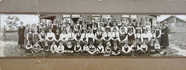
Photograph - Woodbury Ladies’ College, 1919
Woodbury College is an indirect predecessor of Preshil School in Kew. Woodbury College was founded in Glenferrie Road by a Miss Harcourt, former principal of Sydenham College, Moonee Ponds. Miss Harcourt maintained the school until the goodwill was purchased in 1908 by Miss LJ Macey, who had previously operated Lillsden Ladies' College in Edgevale Road, between c.1891 and c.1903. The first school was in a rented building on the south side of Cotham Road between Atkins and Davis Streets. In 1910, a new school building was built on the corner of Uvadale Grove and Cotham Road [the building is still extant as of 2020]. Woodbury College was operated by Miss LJ and Miss HJ Macey until 1920. In 1921, the school amalgamated with the newly formed St Andrew's College, Mont Victor Road, Kew (Vic) under the leadership of Rev JT Lawton [who had previously been principal of St Andrew's School of the 'Pathfinder' in South Yarra]. Miss Macey was for a period the Headmistress of the amalgamated school. Another teacher at the school was Miss Margaret JR Lyttle, who in 1931, left St Andrew's to form the Preshil School.A rare panoramic photograph of Woodbury College in Kew, Victoria. The photograph is part of a large collection of original manuscripts and ephemera relating to the school.Panoramic photograph of the students and teachers of Woodbury College, Cotham Road (Kew). Students identified in the photograph include: Back Row, 5th from left Betty Paton; 4th from right - Jean Strickey (sic).Annotation to reverse: "Woodbury College (Miss L.J. Massey) established Cotham Rd Kew. Est. at this venue 1908. Later joined by Rev. J.T. Lawton & formed a school in Mount Victor Rd Kew St Andrew’s College in 1921.’ woodbury college, cotham road (kew), education, schools, kew, l.j. massey, j.t. lawton, st andrew's college -
 University of Melbourne, Burnley Campus Archives
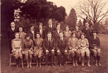
Photograph - Black and white and sepia prints and negatives, C.J. Frazer, Students and Staff. Mr. Rae on the Long Border, 1922-1923
1 copy used in a display in Burnley Library Nov 1995. Note by T.H. Kneen 4 December 1991, "1922 or 3 Back Row (L to R): Fred Sala, Kath Keynes, Miss Pye (Parttime), ?,Fred Gillespie, Clara Broadhurst, Jean Borrett, Kathleen Curry, Alex Jessep. Front Row: Joan Anderson?, Violet Warren?, Miss Northcote, Mr. Rae, ?, Kathie Clark (Tas), Dorothy Allender, Mrs Hedges (Kathleen Curry married Charles Fryer ex-Longerenong student. Together they established Fryer's Nursery in Glenferrie Rd., Hawthorn." (4) 2 copies of photograph, 1 on reverse, "1922 Mr Rae Principal c.1923." Stamp, "Burnley Horticultural College Swan Street, Richmond, Victoria. Photographer was C.J. Frazer, Melbourne (embossed). This photograph appears as an illustration in, "Green Grows Our Garden," A.P. Winzenried, p68. The caption states, "Alex Jessep (sic) admiring an Umbrella Palm from Lord Howe Island near the herbaceous border along the orchard fence." Note by T.H. Kneen 11 December 1991, "Location is the pathway along the Long Border adjoining the Orchard fence. "(1) 2 black and white negatives joined. (2) The 2 negatives developed. (3) 3 copies Group photograph of Students and Staff some seated on a bench and some standing behind.. (4) 2 copies sepia photograph Mr Rae , Principal, on the Long Border (looks like the Orchard Border).On reverse of 1 copy, "1922 Mr Rae Principal, c.1923 Mr. Alex Jessep Lecturer in Botany & Chemistry."Stamp" Burnley Horticultural College Swan Street, Richmond, Victoria."students, staff, mr rae, principal, a.w jessep, lecturer, botany, chemistry, burnley horticultural college, fred sala, kath keynes, miss pye, clara broadhurst, jean borrett, kathleen curry, joan anderson, violet warren, kathie clark, dorothy allender, mrs hedges, charles fryer, fryer's nursery, hawthorn, mr rae principal, c.j. frazer, umbrella palm, lord howe island, herbaceous border, r. fred gillespie, miss northcote, orchard border -
 Melbourne Tram Museum
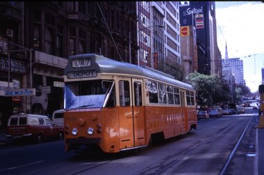
Slide - Set of 11, Ron Scholten, Tram 1041, 1973/1974
Set of 11 colour slides of PCC car 1041 taken during its early operations around Melbourne. Where the slide has a printed date, it is listed. 1 - Collins St, between Elizabeth St and Swanston St, route 47, Depot - Sept. 1973 2 - Batman Ave in Swanston St, route 15, with W2 383 alongside - Sept. 1973 3 - Elizabeth St terminus with Flinders St station in the background - route 19, North Coburg - Sept. 1973 4 - Arriving Batman Ave terminus, route 70, - Sept. 1973 5 - ditto 6 - Bourke St Mall, route 96 East Brunswick - during a trial closure of Bourke St between Elizabeth Street and Swanston Street , given the seats outside Buckley's store - Nov. 1973 7 - Night photo - TMSV slide - MP166 8 - turning from Glenferrie Road into High St - route 6 Glen Iris - a very tight turn - TMSV slide 9 - Wattle Park terminus, route 70 - 1974 10 - Flinders St -route 74 near William St with the railway viaduct in the background. 1974 11 - Interior photo - Ron Scholten - 1973Yields information about PCC car 1041, a prototype all electric tramcarSet of 11 Kodachrome colour slides, cardboard mounts.tramways, pcc class, tram 1041, collins st, elizabeth st, batman ave, st kilda rd., glenferrie road, wattle park, flinders st, interior, bourke st, route 19, route 70, route 74, route 15, route 47, w2 class, tram 383, route 6, route 96, trams -
 Melbourne Tram Museum
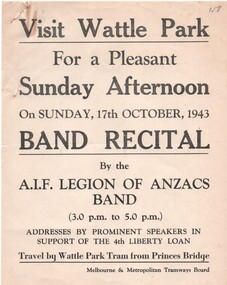
Document - Notice, Report, Melbourne & Metropolitan Tramways Board (MMTB), "Wattle Park Band Recital", Oct. 1943
Set of six documents associated with a Wattle Park band recital by the AIF Legion of Anzacs band on Sunday 17 October 1943 in support of the 4th Liberty Loan. .1 - printed poster advertising the afternoon and travel by tram from Princes Bridge. .2 - duplicated notice from the Assistant Manager to Depots dated 13/10/1943 about the bus to be used to transport band members from Elizabeth St to Wattle Park - Central Bus Depot - notes the bus had been specially prepared for the event. .3 - typed notice from the District Traffic Superintendent to Hawthorn and Camberwell depots about special trams for the event and arrangements for conductors. Signed by J. M. Harry rubber stamp. .4 - hand written in blue indelible pencil on ruled paper, the table for the special cars for the event. .5 - hand written notes on heavy card of timing and loading on trams at Glenferrie Road. Signed R. Whitelaw. .6 - ditto for loading ex Wattle Park loop - signed by A? Cameron.1 - has a pencil inscription "158" in the top left hand corner. .3 - has a pencil note "Copy sent Hawt Insp with table" along the bottom edge.trams, tramways, mmtb, world war 2, wattle park, events, bands, buses, hawthorn depot, camberwell depot