Showing 918 items
matching heritage places
-
 Eltham District Historical Society Inc
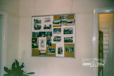
Photograph, Heritage Week Display, Andrew Ross Museum, 27 March 1993
The Andrew Ross Museum was offically opened on 27th March 1993 as part of heritage week. A book launch of "Reminscences of Andrew Ross" was also launched. A set of photographs taken illustrate the displays in place at the time.Colour photographactivities, andrew ross museum, heritage week -
 Eltham District Historical Society Inc
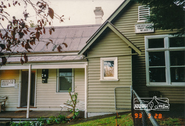
Photograph, Andrew Ross Museum, 28 March 1993
The Andrew Ross Museum was offically opened on 27th March 1993 as part of heritage week. A book launch of "Reminscences of Andrew Ross" was also launched. A set of photographs taken illustrate the displays in place at the time.Colour photographactivities, andrew ross museum, heritage week -
 Eltham District Historical Society Inc
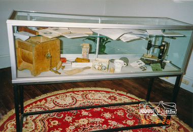
Photograph, Heritage Week Display, Andrew Ross Museum, 28 March 1993
The Andrew Ross Museum was offically opened on 27th March 1993 as part of heritage week. A book launch of "Reminscences of Andrew Ross" was also launched. A set of photographs taken illustrate the displays in place at the time.Colour photographactivities, andrew ross museum, heritage week -
 Eltham District Historical Society Inc
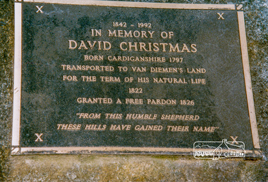
Photograph, David Christmas Memorial Plaque, Heritage Excursion, 22 October 1996, 22/10/1996
The David Christmas memorial is situated on the south side of One Tree Hill Road, at Watsons Creek. As a young man, Welshman David Christmas had been transported to Van Dienman's Land for a relatively minor offence. In 1836, having received a pardon, he came to Port Phillip, where, in 1842, he was hired as a shepherd by district pioneer, Joseph Stevenson. In 1992, a roadside plaque commemorating the shepherd who gave his name to the district was set in place over his presumed bush gravesite. The plaque was unveiled by two of Stevenson's grandsons, Bruce and Don Ness. FROM: Christmas Hills Past and Present, Yarra Glen & District Historical Society, 2004. The plaque reads: 1842-1992 In memory of David Christmas born Cardiganshire 1797 Transported to Van Dieman's Land for the term of his natural life 1822 Granted a free pardon 1826 "From this humble shepherd these hills have gained their name"Colour photographactivities, heritage excursion, david christmas, watsons creek, christmas hills, plaque -
 Glen Eira Historical Society
Album - Album page, "Ripponlea", Hotham Street, Circa 1972
This photograph is part of the Caulfield Historical Album 1972. This album was created in approximately 1972 as part of a project by the Caulfield Historical Society to assist in identifying buildings worthy of preservation. The album is related to a Survey the Caulfield Historical Society developed in collaboration with the National Trust of Australia (Victoria) and Caulfield City Council to identify historic buildings within the City of Caulfield that warranted the protection of a National Trust Classification. Principal photographer thought to be Trevor Hart, member of Caulfield Historical Society. Most photographs were taken between 1966-1972 with a small number of photographs being older and from unknown sources. All photographs are black and white except where stated, with 386 photographs over 198 pages.From Victorian Heritage Database citation for Rippon Lea H0614 https://vhd.heritagecouncil.vic.gov.au/places/427(as at 23/10/2020) Rippon Lea was commenced in 1868 by Frederick Sargood, a most successful politician and merchant. He was born in England in 1834 and arrived in Melbourne in 1850. He soon joined his father's wholesale soft goods firm, spending some time as its manager on the goldfields. Sargood entered the Legislative Council in 1874. He was Victoria?s first Minister for Defence in 1883. Sir Frederick Sargood was created CMG. In 1885 and KCMG in 1890 as a reward for his contribution to public life. He died suddenly in 1903. Rippon Lea was designed by the leading firm of architects, Reed and Barnes. Joseph Reed had travelled in Europe in 1863, including northern Italy. When he returned he introduced the use of polychromy. While not the first examples, Rippon Lea and the Independent Church in Collins Street were the best and set a fashion which became a distinctly Melbourne style, particularly used for houses and churches. Its popularity was possible because of the new availability of different coloured bricks. Reed's fine Lombardic Romanesque details soon became debased by others. As Sargood's family grew and his fortunes prospered, Rippon Lea was extended to include 33 rooms - a complete mansion. The cast iron porte cochere and the northern conservatory were added in 1897. The architects were Taylor and Fitts. The ballroom was added in 1882 and remodelled in 1889. Many alterations have changed the interior and exterior during the ownerships of Benjamin Nathan and later his daughter Mrs Louisa Jones in the 1930s and are in their own right of significance. Sir Thomas Bent owned the property from 1903 until 1911 but never lived there. He subdivided much of the land. The original garden dates from about 1868, and it seems that William Guilfoyle of the Botanic Gardens was involved. It was redesigned in a more natural style in the 1880s by Sargood and his head gardener, Adam Anderson. The lake, waterfalls, fernery, hill and grotto are balanced by mighty deciduous trees and conifers. These are interspersed with, but never dominated by Australian species such as eucalyptus and other exotics. The sinuous drive with its carefully prepared approach to the house is notable. The original vegetable gardens, orchard and outer paddocks no longer survive. The shade house is important as the largest known in Australia and possibly the world. Its curved plan and form of construction are particularly notable. It was built about 1884.Page 94 of Photograph Album with four photographs (three landscape and one portrait) of Ripponlea - stables, lookout and neighbouring cottages.Handwritten: "Ripponlea" Hotham Street [top right] / Neg 256 Dec 1972 STABLES [under top left photo] / Neg 248 Dec 1972 LOOKOUT [under top right photo] / Neg 254 Dec 1972 / COTTAGES WILLOW STREET [under bottom left photo] / Neg 259 Dec 1972 STABLES [under bottom right photo] / 94 [bottom right]trevor hart, elsternwick, mansion, hotham street, frederick sargood, reed and barnes, 1860's, 1890's, 1880's, benjamin nathan, nathan, louisa jones, thomas bent, sir thomas bent, william guilfoyle, guilfoyle, adam anderson, ripponlea, victorian, sir frederick sargood, architects, bricks, polychrome bricks, taylor and fitts, stables, lookouts, cottages, outbuildings, rippon lea -
 Glen Eira Historical Society
Album - Album page, Hotham Street, Circa 1972
This photograph is part of the Caulfield Historical Album 1972. This album was created in approximately 1972 as part of a project by the Caulfield Historical Society to assist in identifying buildings worthy of preservation. The album is related to a Survey the Caulfield Historical Society developed in collaboration with the National Trust of Australia (Victoria) and Caulfield City Council to identify historic buildings within the City of Caulfield that warranted the protection of a National Trust Classification. Principal photographer thought to be Trevor Hart, member of Caulfield Historical Society. Most photographs were taken between 1966-1972 with a small number of photographs being older and from unknown sources. All photographs are black and white except where stated, with 386 photographs over 198 pages.Victorian Heritage Database - Hotham Street Road Overbridge HO116 Heritage Overlay - City of Glen Eira https://vhd.heritagecouncil.vic.gov.au/places/43557 (as of 04/07/2021) The Hotham Street road overbridge is located on the Sandringham railway line between Ripponlea and Elsternwick railway stations. It is presumed to have been built by contractors Sharp and Campbell who signed a contract on 25th . November, 1881 to construct a second line of railway between Windsor and Elsternwick. This contract was completed during 1882 and the bridge may have been designed in the year when Robert Watson took over from William Elsdon as engineer in chief for the Victorian railways. It is historically, aesthetically and technically significant. It is historically significant (Criterion A) to the extent that it demonstrates the standards of construction adopted by the Victorian Railways Department when it rebuilt the lines acquired from the private railway companies, (compare the Geelong and Melbourne Railway Co's line from Newport to Geelong, acquired in 1860). It is aesthetically significant (Criterion E) as an intact nineteenth century structure of its type, many similar girder bridges having been renewed with concrete girders in recent years. The bluestone abutments demonstrate high standards of stone masonry and are representative of Departmental work of the period. This bridge forms one of a group of historic structures on the railway to Brighton Beach and therefore contributes to the line's cultural importance as a whole. The survival of the riveted iron girders with their bellied angle iron struts is important since these elements are representative of the civil engineering practices of the Victorian Railways at the time and constitute the technical significance (Criterion F) of the structure.Page 96 of Photograph Album with three photographs (one portrait and two landscape) from Hotham Street - two external views of one house and a railway bridge.Handwritten: Hotham Street [top right] / 112 HOTHAM ST [under top left photo] / BRIDGE OVER SANDRINGHAM RAILWAY [under top right photo] / 112 HOTHAM ST CNR MELBY AVE [under bottom left photo] / 96 [bottom right]trevor hart, elsternwick, hotham street, caulfield, houses, brick, bay windows, verandahs, railway bridges, tunnels, gardens, bluestone, civil engineering, victorian railways, sharp and campbell, contractors -
 Glen Eira Historical Society
Album - Album page, Glenfern, Inkerman Street, Circa 1972
This photograph is part of the Caulfield Historical Album 1972. This album was created in approximately 1972 as part of a project by the Caulfield Historical Society to assist in identifying buildings worthy of preservation. The album is related to a Survey the Caulfield Historical Society developed in collaboration with the National Trust of Australia (Victoria) and Caulfield City Council to identify historic buildings within the City of Caulfield that warranted the protection of a National Trust Classification. Principal photographer thought to be Trevor Hart, member of Caulfield Historical Society. Most photographs were taken between 1966-1972 with a small number of photographs being older and from unknown sources. All photographs are black and white except where stated, with 386 photographs over 198 pages.From Victorian Heritage Database citation for Glernfern H0136 https://vhd.heritagecouncil.vic.gov.au/places/57 (as at 23/10/2020) Glenfern was built on spacious grounds at the corner of Inkerman and Hotham Streets, East St Kilda in two main stages in 1857 and 1876. From 1876 to 1984 Glenfern had only two owners, including the well known Melbourne family of artists, the Boyds. The property was bequeathed to the National Trust of Australia (Victoria) in 1984 and has remained in their ownership. The original Glenfern allotment was bought by John Bakewell in 1856 and sold the following year to Francis McDonnell, a prominent Melbourne investor. By 1858, the house, rated as the most valuable in Caulfield, had been built on the site. Due to financial difficulties, McDonnell offered a number of properties for sale in 1860, including Glenfern. It was not sold at this stage, but subsequently mortgaged in 1862. In 1866 Thomas Watson purchased the property and lived there until 1876 when it was sold to Captain John T. T. Boyd and his wife, Lucy, founders of the Boyd dynasty of artists, musicians, writers and architects. The Boyd family, including twelve children, lived there until 1907, with Lucy Boyd retaining ownership after her husband's death in 1891. In 1907 the property was subdivided and the greatly reduced Glenfern portion was purchased by the Ostberg family, who lived there from 1915. In the latter years of Boyd family ownership and the Ostberg ownership, Glenfern had several tenants and was run as a school on two occasions. The Ostberg family occupancy continued until the death of Miss Amy Ostberg in 1984. From 1929 the property was listed as Glenfern Flats, necessitating various internal alterations over a period of time. The original two storey house, attributed to architect Charles Laing, was extended for the Boyd family in 1876, by architect M. Hennessy. This comprised the addition of a two storey wing to the south of the existing building. Stables were built in 1884 by the architects Smith and Johnson and other outbuildings, since removed, were recorded on the site. The gardens were developed from the establishment of the estate and remnants of early plantings, exotic trees in particular, are evident. Various additions and alterations were made to the house in the twentieth century and a separate block of flats was built on the southern boundary in c1964. Glenfern is a two storey picturesque Gothic house of stuccoed brick with steep, gabled slate roofs, elaborate bargeboards and chimneys of conjoined stacks set diagonally. The original, asymmetrically planned L-shaped house, containing the principal rooms and a rear wing, was designed with two main facades facing north and west. The north facade contains an unusual recessed pointed arch bay formed between twin chimney flues. Internally cedar joinery includes an unusual set of double doors between the drawing room and parlour, the centre pair of which fold back and then slide into the walls. Detailing of the 1876 additions copied that of the original house, including the bargeboards, chimneys and western verandah. Ownership of Glenfern passed to the National Trust of Australia (Victoria) in 1984 and in 2002 transformation of the property into a Centre for the Arts and Culture commenced. This began with the establishment of an Artist-in-residence programme, followed by the Glenfern Writers Centre. Restoration and renovation of the building has been undertaken concurrently with the establishment of this centre. How is it significant? Glenfern, East St Kilda is of architectural and historical significance to the State of Victoria. Why is it significant? Glenfern is of architectural significance as an unusually intact and rare example of the picturesque domestic Gothic Revival house in Victoria. Of particular note are the clustered chimneys, bargeboards and twin arched chimney flues and the folding/sliding cedar doors between the principal rooms. It is significant as an important work of the prominent Melbourne architect, Charles Laing. Glenfern is of historical significance for its connection with the distinguished Victorian Boyd family. It has been recorded in a painting by Emma Boyd, wife of Arthur, in 1885 and in print by writer, Martin Boyd in 1952. Glenfern is of historical significance due to its ownership by only two families from 1876; firstly the Boyds until 1907 and the Ostbergs until 1984. Of note is the resistance to redevelopment in the latter half of the twentieth century and the subsequent survival of the 1907 Glenfern estate.Page 98 of Photograph Album with two photographs (one square and one landscape) of views of Glenfern.Handwritten: "Glenfern" 417 Inkerman Street [top right] / 98 [bottom right]trevor hart, east st kilda, garden, pitched roof, glenfern, hotham street, boyd family, 1850's, 1860's, 1870's, john bakewell, francis mcdonnell, thomas watson, lucy boyd, glenfern flats, charles laing, m. hennessy, smith and johnson, stables, gothic, stuccoed brick, gabled slate roofs, elaborate bargeboards, asymmetrical, cedar joinery, verandah, national trust of australia, centre for the arts and culture, artist-in-residence, glenfern writers centre, gothic revival, clustered chimneys, emma boyd, inkerman street, north caulfield, captain john boyd, artists, writers, st kilda east, national trust of australia (victoria), caulfield, amy ostberg, architects, m hennessy, doors, chimneys, martin boyd, arthur boyd, ostberg family -
 Glen Eira Historical Society
Album - Album page, Kambrook Road, Circa 1972
This photograph is part of the Caulfield Historical Album 1972. This album was created in approximately 1972 as part of a project by the Caulfield Historical Society to assist in identifying buildings worthy of preservation. The album is related to a Survey the Caulfield Historical Society developed in collaboration with the National Trust of Australia (Victoria) and Caulfield City Council to identify historic buildings within the City of Caulfield that warranted the protection of a National Trust Classification. Principal photographer thought to be Trevor Hart, member of Caulfield Historical Society. Most photographs were taken between 1966-1972 with a small number of photographs being older and from unknown sources. All photographs are black and white except where stated, with 386 photographs over 198 pages. https://vhd.heritagecouncil.vic.gov.au/places/43737 - re 26 Kambrook Road and 345 Balaclava Road corner building: A prominently situated two-storeyed complex of late Victorian buildings consisting of "Wybar's Buildings" occupying the Balaclava Road/ Kambrook Road corner and the "Caulfield Bakery" facing Kambrook Road, separated by a driveway from a single storeyed shop. The main building has a comer splay and balustraded parapet with curved pediments, the words "Wybar's Buildings 1887" having been obliterated but "Caulfield Bakery 1887" with the characteristic wheatsheaf surviving in raised cement work. The walls are stuccoed and richly ornamented with bracketed cornices and keystones with masks extending to the Bakery. The main building is further distinguished by the Masonic symbol of the mason's dividers in the pediment whilst the upper level of the bakery is in overpainted brickwork. The single storeyed shop incorporates the bracketed cornice and consoles characteristic of the main buildings and is in other respects a utilitarian structure. https://vhd.heritagecouncil.vic.gov.au/places/35413 - re 16 Kambrook Road A small late Victorian Italianate villa distinguished by its parapeted window bays either side of a small verandah with encaustic tiled floor. The parapets are balustraded with console enrichment and glazed tiles, the stuccoed surfaces being unpainted. Ornamentation is in other respects undistinguished. https://www.gleneira.vic.gov.au/services/planning-and-building/heritage/heritage-management-plan - re 9-11 Kambrook Road ... they demonstrate most of the commonly employed aesthetic devices characteristic of the Italianate Style including patterned brickwork, patterned slate roofs, cast iron lace verandahs, ornamental stucco work and ashlar boards...https://vhd.heritagecouncil.vic.gov.au/places/43737 - 345 Balaclava and 26 Kambrook Roads HO91 in City of Glen Eira "Wybar's Buildings" at the corner of Balaclava Road and Kambrook Road are important as a prominent late Victorian commercial development incorporating a variety of activities including a bakery and possibly a coffee palace, the latter understood to be unique within the municipality, but characteristic of the period. It is a rare complex of its type in Caulfield and is important also as evocative evidence of the late Victorian Land Boom and the creation of a small now defunct commercial centre at this location by the George Wybrow. https://vhd.heritagecouncil.vic.gov.au/places/35413 - 16 Kambrook Road HO121 in City of Glen Eira ''Hollywood'' at 16 Kambrook Road is of architectural interest for its pavilions which retain their unpainted parapets and ornamental tiles in the manner of other less imposing examples in the immediate locality possibly linked with the builder George Wybar and his son, who undertook substantial projects nearby. Its association with James Yorston, presumably is Yorston of Dickson and Yorston, important builders and estate developers at Caulfield during the Inter war period is of interest. https://www.gleneira.vic.gov.au/services/planning-and-building/heritage/heritage-management-plan - re 9-11 Kambrook Road HO152 Normanby Road/Kambrook Road, Caulfield North Statement of Significance: The Precinct is historically significant for its capacity to demonstrate standards of design and building construction in this part of the municipality during the late Land Boom years and especially just prior to the bank collapse of 1891. The housing stock is representative of the standards of amenity excepted by the middle classes of Melbourne society at the time, including artists, (horse) trainers, jockeys, managers, travellers, journalists and the like, also having a functional link with the activities of the Caulfield Racecourse which forms an important element in the history of the Municipality. The row of attached pairs at 5-11 Kambrook Road and 53-67 Kambrook Road is especially significant in this respect in that the narrow allotments are indicative of the owner/developer’s determination to maximise profits at the height of the Land Boom in 1891...Page 104 of Photograph Album with four photographs (landscape) of three different properties on Kambrook Road.Handwritten: Kambrook Road [top right] / WYBAR'S BUILDING 1887/ INC CAULFIELD BAKERY / [under top right photo] / 16 KAMBROOK ROAD / 1970 HIRST MRS J.N.[under bottom left photo] / 11-9 KAMBROOK ROAD / 1970 9-BUCKLAND MRS L.A / 11- ATKINS MRS N.E. [under bottom right photo] / 104 [bottom right]trevor hart, kambrook road, victorian, caulfield north, parapets, wybar's buildings 1887, caulfield bakery 1887, architectural features, painted bricks, balaclava road, victorian italianate style, houses, bay windows, verandahs, glazed tiles, shops, george wybar, builders, james yorston, dickson and yorston, j n hirst, l a buckland, n e atkins, patterned slate roofs, patterned bricks, cast iron work, attached houses -
 Glen Eira Historical Society
Album - Album page, Rosemont, 112 Kooyong Road, Circa 1972
This photograph is part of the Caulfield Historical Album 1972. This album was created in approximately 1972 as part of a project by the Caulfield Historical Society to assist in identifying buildings worthy of preservation. The album is related to a Survey the Caulfield Historical Society developed in collaboration with the National Trust of Australia (Victoria) and Caulfield City Council to identify historic buildings within the City of Caulfield that warranted the protection of a National Trust Classification. Principal photographer thought to be Trevor Hart, member of Caulfield Historical Society. Most photographs were taken between 1966-1972 with a small number of photographs being older and from unknown sources. All photographs are black and white except where stated, with 386 photographs over 198 pages.From Victorian Heritage Database citation for Rosemont HO124 - 112 Kooyong Road Caulfield North https://vhd.heritagecouncil.vic.gov.au/places/35588 Rosemont'' is situated at no.112A Kooyong Road, Caulfield North and was built in 1869 for Godfrey Howitt, physician, president and honorary physician of the Melbourne Benevolent Society, Council member of the University of Melbourne and founding vice president of the Royal Society of Victoria. It is historically significant (Criterion A) as an early and substantial villa residence demonstrating Caulfield's early attraction as a residential retreat for Melbourne's elite. This significance is enhanced by the associations of the place with Godfrey Howitt and later James Grice, National Bank chairman and owner of "Stonnington" in Glenferrie Road, Malvern and Thomas King, councillor and successful negotiator for the extension of the electric tramway system to the Municipality.Page 110 of photograph album with 4 photos (portraits) of varying views of Rosemont's exterior and garden.Handwritten: "Rosemont" 112 Kooyong Road [top right] / Neg 97 1972 / [under top right photo] / 110 [bottom right]trevor hart, caulfield, john bakewell, francis mcdonnell, gabled slate roofs, rosemont, caulfield north, kooyong road, 1860's, godfrey howitt, james grice, thomas king, villa residence, decorative brickwork, curved windows, bay window, garden, victorian style, mansions, polychrome bricks, porches, arches, parapets, verandahs, slate roofs -
 Glen Eira Historical Society
Album - Album page, Rosemont, 112 Kooyong Road, Circa 1972
This photograph is part of the Caulfield Historical Album 1972. This album was created as part of a project from approximately 1966-1972 by the Caulfield Historical Society to assist in identifying buildings worthy of preservation. This album is related to a Survey the Caulfield Historical Society developed in collaboration with the National Trust of Australia Victoria and Caulfield City Council to identify historic buildings within the City of Caulfield that warranted the protection of a National Trust Classification. Photographers Jenny O’Donnell and Trevor Hart, members of Caulfield Historical Society. Some photographs are older and from unknown sources. All photographs are black and white except where stated.From Victorian Heritage Database citation for Rosemont - HO124 112 Kooyong Road Caulfield North https://vhd.heritagecouncil.vic.gov.au/places/35588 Rosemont'' is situated at no.112A Kooyong Road, Caulfield North and was built in 1869 for Godfrey Howitt, physician, president and honorary physician of the Melbourne Benevolent Society, Council member of the University of Melbourne and founding vice president of the Royal Society of Victoria. It is historically significant (Criterion A) as an early and substantial villa residence demonstrating Caulfield's early attraction as a residential retreat for Melbourne's elite. This significance is enhanced by the associations of the place with Godfrey Howitt and later James Grice, National Bank chairman and owner of "Stonnington" in Glenferrie Road, Malvern and Thomas King, councillor and successful negotiator for the extension of the electric tramway system to the Municipality.Page 111 of photograph album with 1 photograph (portrait) of Rosemont's roof line.Handwritten: 111 [bottom left]trevor hart, caulfield, john bakewell, francis mcdonnell, gabled slate roofs, rosemont, caulfield north, kooyong road, 1860's, godfrey howitt, james grice, thomas king, decorative brickwork, bay window, garden, mansion, chimneys, victorian architectural style, polychrome bricks, roofs -
 Glen Eira Historical Society
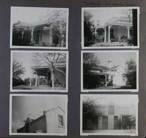
Album - Album page, Lirrewa, 1-3 Lirrewa Grove, Circa 1972
This photograph is part of the Caulfield Historical Album 1972. This album was created in approximately 1972 as part of a project by the Caulfield Historical Society to assist in identifying buildings worthy of preservation. The album is related to a Survey the Caulfield Historical Society developed in collaboration with the National Trust of Australia (Victoria) and Caulfield City Council to identify historic buildings within the City of Caulfield that warranted the protection of a National Trust Classification. Principal photographer thought to be Trevor Hart, member of Caulfield Historical Society. Most photographs were taken between 1966-1972 with a small number of photographs being older and from unknown sources. All photographs are black and white except where stated, with 386 photographs over 198 pages.From Victorian Heritage Database citation for Lirrewa - HO39 Tarqua and Stables, 1-3 Lirrewa Grove Caulfield South https://vhd.heritagecouncil.vic.gov.au/places/120932 (as at 26/10/2020) "Tarqua", now "Lirrewa", is situated at nos. 1-3 Lirrewa Grove, Caulfield South, and was built in 1886 for Montague William Langdon, son of the merchant Joseph Henry Langdon of nearby "Rosecraddock". It is historically and aesthetically significant. It is historically significant (Criterion A) as one of the Langdon family residences, comparing in Glen Eira also with "Rosecraddock" at 10 Craddock Avenue (1857) and "Hengar" at 356 Glen Eira Road (1889-90). It is aesthetically significant (Criterion E) for its capacity to demonstrate the stylistic influences prevailing at the time especially for substantial residences. At "Tarqua", the design acknowledges the prevailing popularity of the Italian Style in the shallow hipped roof form and symmetrical facade as well as the picturesque Gothic Revival style demonstrated especially by the use of pointed arches, fretted barges and the battlemented parapeted section. This latter style was particularly attractive to persons of means on account of its English precedents, the combination of influences being skillfully handled in this instance.Page 120 of Photograph Album with six photographs (all landscape) of views of Lirrewa, mostly including its garden.Handwritten: "Lirrewa" 1-3 Lirrewa Grove [top right] / 120 [bottom right]trevor hart, verandah, lirrewa, tarqua, 1880's, montague william langdon, italian style, shallow hipped roof, symmetrical facade, gothic revival, pointed arches, fretted barges, battlemented parapet, terraces, boom era, single storey, timber roof brackets, frieze, gables, cast iron ridging, lirrewa grove, cast iron work, caulfield, arches, parapets, gardens, houses, victorian style, caulfield south -
 Glen Eira Historical Society
Album - Album page, Lirrewa, 1-3 Lirrewa Grove, Circa 1972
This photograph is part of the Caulfield Historical Album 1972. This album was created in approximately 1972 as part of a project by the Caulfield Historical Society to assist in identifying buildings worthy of preservation. The album is related to a Survey the Caulfield Historical Society developed in collaboration with the National Trust of Australia (Victoria) and Caulfield City Council to identify historic buildings within the City of Caulfield that warranted the protection of a National Trust Classification. Principal photographer thought to be Trevor Hart, member of Caulfield Historical Society. Most photographs were taken between 1966-1972 with a small number of photographs being older and from unknown sources. All photographs are black and white except where stated, with 386 photographs over 198 pages.From Victorian Heritage Database citation for - HO39 Tarqua and Stables, 1-3 Lirrewa Grove Caulfield South https://vhd.heritagecouncil.vic.gov.au/places/120932 as at (26/10/2020) "Tarqua", now "Lirrewa", is situated at nos. 1-3 Lirrewa Grove, Caulfield South, and was built in 1886 for Montague William Langdon, son of the merchant Joseph Henry Langdon of nearby "Rosecraddock". It is historically and aesthetically significant. It is historically significant (Criterion A) as one of the Langdon family residences, comparing in Glen Eira also with "Rosecraddock" at 10 Craddock Avenue (1857) and "Hengar" at 356 Glen Eira Road (1889-90). It is aesthetically significant (Criterion E) for its capacity to demonstrate the stylistic influences prevailing at the time especially for substantial residences. At "Tarqua", the design acknowledges the prevailing popularity of the Italian Style in the shallow hipped roof form and symmetrical facade as well as the picturesque Gothic Revival style demonstrated especially by the use of pointed arches, fretted barges and the battlemented parapeted section. This latter style was particularly attractive to persons of means on account of its English precedents, the combination of influences being skillfully handled in this instance.Page 121 of Photograph Album with one landscape photograph of Lirrewa - external view of a bay window.Handwritten: Lirrewa [top left ] / 121 [bottom left]trevor hart, verandah, lirrewa, tarqua, 1880's, montague william langdon, italian style, shallow hipped roof, symmetrical facade, gothic revival, pointed arches, fretted barges, battlemented parapet, ornamented parapets, terraces, boom era, timber roof brackets, frieze, gables, cast iron ridging, lirrewa grove, bay window, cast iron work, lead lights, houses, victorian style, caulfield, caulfield south -
 Glen Eira Historical Society
Album - Album page, Labassa, 4 Manor Grove, Circa 1972
This photograph is part of the Caulfield Historical Album 1972. This album was created in approximately 1972 as part of a project by the Caulfield Historical Society to assist in identifying buildings worthy of preservation. The album is related to a Survey the Caulfield Historical Society developed in collaboration with the National Trust of Australia (Victoria) and Caulfield City Council to identify historic buildings within the City of Caulfield that warranted the protection of a National Trust Classification. Principal photographer thought to be Trevor Hart, member of Caulfield Historical Society. Most photographs were taken between 1966-1972 with a small number of photographs being older and from unknown sources. All photographs are black and white except where stated, with 386 photographs over 198 pages. HISTORY:-- From Victorian Heritage Database citation for Labassa https://vhd.heritagecouncil.vic.gov.au/places/278 as at (26/10/2020) Labassa, Caulfield is one of Melbourne's most lavishly decorated nineteenth century mansions. It resulted from the extensive remodelling in 1890, of an earlier house, known as Sylliott Hill, which was begun in 1862-3 for lawyer, Richard A. Billing. The land at the corner of Balaclava and Orrong Roads was first acquired in 1854 by William Lyall, transferred to his partner, John Mickle, in 1859, who also acquired the adjoining allotment in Balaclava Road, and the three allotments were conveyed to Billing. His first eight-roomed house was extended significantly in 1873 into a twenty-roomed house by architects Crouch and Wilson, who were possibly also responsible for the first house. This reflected Billing's success as a barrister, and he resided at this property until his death in 1882. In 1883 prominent Melbourne businessman, Alexander William Robertson, leased the Sylliott Hill property from Billing's widow, and in 1885 he purchased the adjoining allotment in Balaclava Road. He purchased the Billing's property in 1887 and renamed the 6.31 hectare property, Ontario. In 1889-90, Robertson commissioned the German born architect, John A. B. Koch, to extensively remodel the house into a thirty-five roomed mansion. The existing house was extended and altered, largely resulting in the nineteenth century mansion as it now appears. After Robertson's death in 1896, the house was tenanted until it was eventually sold to the mining millionaire, John Boyd Watson, in 1904. He renamed the property Labassa and carried out repair and re-decoration work to the house. In the early twentieth century, many large estates were subdivided into smaller allotments as the demand for land grew and it became difficult to maintain such large estates. After Watson's death in 1911, portions of the Labassa estate were offered for sale, with Mrs Watson retaining a 1.73 hectare portion containing the house. In 1913 forty-six allotments were auctioned at Labassa Estate, with the formation of Labassa Grove and Ontario Street to the east of the property. Labassa was first recorded as containing flats in 1923 and in the late 1920s, the owner, Robert Hannon, built a red brick block of flats adjacent to the house. Subdivision continued, until the National Trust of Australia (Victoria) purchased the house in 1980 and subsequently purchased adjoining sites, one to the south-east in 1984 (house demolished in 1988) and to the west in 1988. Labassa as it now stands is substantially as it appeared when Koch completed the work in 1890. The original two storey house was transformed into a French Renaissance style mansion, with the addition of a two level L-shaped arcaded verandah and two prominent terminating bays to the south and the east. The building is of unpainted cement render with dressed bluestone plinths, balustraded parapet and steep, slate covered, flat topped mansard roofs behind. A truncated conical roof is a feature of the south bay and a helmeted head is incorporated in the parapet over the east bay. The main south and east facades incorporate many cast cement details, including sculptures, elaborate cornices, swagged Corinthian columns and caryatid consoles flanking the entrance porch, as well as pink marble panels and imitation marble, or scagliola, on curved surfaces. At the rear of the building is a two storey wing and a single storey cottage, the former being connected to the main house by a tower. This section of the house was constructed in 1873. The estate at its peak included stables (1873), conservatory (probably 1890) and a tennis pavilion (probably 1890). All of these outbuildings survive, with the stables and conservatory being converted for residential use after 1922. Internally a range of decorative treatments remain from the late nineteenth century and the early twentieth century, both from the Robertson and Watson periods of occupancy. These include wallpapers, ceiling decoration, chimney pieces, mouldings, joinery and decorative glass. From Victorian Heritage Database citation for H0135 Labassa 2/2A Manor Grove Caulfield North https://vhd.heritagecouncil.vic.gov.au/places/278 as at (26/10/2020) HOW IS IT SIGNIFICANT? Labassa, Caulfield is of architectural, aesthetic and historical significance to the State of Victoria. WHY IS IT SIGNIFICANT? Labassa, Caulfield is of architectural significance as the most prominent example of a small number of houses built in Australia in the French Renaissance style. It is of further note due to the German interpretation of the style and the use of Hellenistic sources, via Germany. It is exceptional for its lavish treatment externally, including marble, scagliola, caryatids, swagged columns, mansard roofs and ornamental cresting. Labassa is of architectural significance as the most important surviving example of German architect, John Koch's domestic work. He undertook a large variety of work in Melbourne, including a number of houses, however Labassa is the most lavish example of his work. Labassa is of aesthetic significance for its outstanding assemblage of late nineteenth and early twentieth century European style interior decoration, which remain remarkably intact. These include a trompe l'oeil ceiling, painted ceilings, embossed imitation leather and other papers, chimney pieces, ceramic tilework, oak parquetry and stained glass, including a tripartite window by Ferguson and Urie, probably dating from the 1873 period. Labassa is of historical significance as an illustrative example of the wealth acquired by a number of prominent Victorian families in the second half of the 19th century. The early development of the property, Sylliott Hill, was due to the wealth acquired by Richard Billing, barrister and fifth Victorian to be appointed Queen's Counsel in 1878. The significant development in 1890 of Ontario, is illustrative of the wealth of Alexander Robertson, a partner in Cobb and Co., a director of Goldsborough Mort & Co., and a pastoral speculator. John B. Watson, whose father had acquired great wealth from the goldfields of Bendigo and subsequently invested in city and country properties, was the third resident to impact on the house, particularly the interiors. The Labassa estate is of historical significance as an illustrative example of the development that occurred in such suburbs as Caulfield in the 1880s due to the land boom, its proximity to Melbourne and the establishment of the Melbourne to Gippsland railway in 1879. It is also illustrative of an estate which succumbed to the pressures of subdividing in the early twentieth century, as properties became difficult to maintain and demand for land close to the city grew. It was typically divided into flats in the 1920s and was used as such for about sixty years. It is of historical significance for its associations with the remnants of the earlier estate which remain extant. These include the stables, conservatory (H2005) and tennis pavilion which all remain on separate sites. Also significant are the remains of early electrical wiring and fittings. Labassa was one of the first houses in Caulfield to be electrified and some of the original wires remain. [Online Data Upgrade Project 2004]Page 128 of Photograph Album with four photographs (two portrait and two landscape) of Labassa.Handwritten: "Labassa" 4 Manor Grove [top right] / Neg 232 8 Oct 1966 [under bottom right photo] / 128 [bottom right]trevor hart, bracketed eaves, slate roof, bay windows, decorative brackets, caulfield north, labassa, richard a. billing, balaclava road, orrong road, sylliott hill, william lyall, crouch and wilson, alexander william robertson, ontario, 1880's, john a. b. koch, mansion, john boyd watson, labassa grove, french renaissance style, l-shaped arcaded verandah, bluestone plinths, balustraded parapet, flat topped mansard roofs, conical roof, elaborate cornices, corinthian columns, caryatid consoles, marble panels, imitation marble, scagliola, tower, conservatory, stables, tennis pavilion, mouldings, decorative glass, caryatids, swagged columns, ornamental cresting, trompe l'oeil ceiling, embossed imitation leather, oak parquetry, stained glass, tripartite window, triple window, ferguson and urie, 1870's, flats, 1920's, electric wiring, 1860's, verandahs, curved windows, arched windows, italianate, terraces, gargoyles, ornamentation, ornate entrance, la bassa, manor grove, st kilda east, victorian, cast iron work, john koch, richard billing, architects, electrification, john mickle, land subdivision, mrs watson, labassa estate, robert hannon, national trust of australia (victoria), sculpture -
 Glen Eira Historical Society
Album - Album page, Labassa, 4 Manor Grove, Circa 1972
This photograph is part of the Caulfield Historical Album 1972. This album was created in approximately 1972 as part of a project by the Caulfield Historical Society to assist in identifying buildings worthy of preservation. The album is related to a Survey the Caulfield Historical Society developed in collaboration with the National Trust of Australia (Victoria) and Caulfield City Council to identify historic buildings within the City of Caulfield that warranted the protection of a National Trust Classification. Principal photographer thought to be Trevor Hart, member of Caulfield Historical Society. Most photographs were taken between 1966-1972 with a small number of photographs being older and from unknown sources. All photographs are black and white except where stated, with 386 photographs over 198 pages. HISTORY:-- From Victorian Heritage Database citation for Labassa https://vhd.heritagecouncil.vic.gov.au/places/278 as at (26/10/2020) Labassa, Caulfield is one of Melbourne's most lavishly decorated nineteenth century mansions. It resulted from the extensive remodelling in 1890, of an earlier house, known as Sylliott Hill, which was begun in 1862-3 for lawyer, Richard A. Billing. The land at the corner of Balaclava and Orrong Roads was first acquired in 1854 by William Lyall, transferred to his partner, John Mickle, in 1859, who also acquired the adjoining allotment in Balaclava Road, and the three allotments were conveyed to Billing. His first eight-roomed house was extended significantly in 1873 into a twenty-roomed house by architects Crouch and Wilson, who were possibly also responsible for the first house. This reflected Billing's success as a barrister, and he resided at this property until his death in 1882. In 1883 prominent Melbourne businessman, Alexander William Robertson, leased the Sylliott Hill property from Billing's widow, and in 1885 he purchased the adjoining allotment in Balaclava Road. He purchased the Billing's property in 1887 and renamed the 6.31 hectare property, Ontario. In 1889-90, Robertson commissioned the German born architect, John A. B. Koch, to extensively remodel the house into a thirty-five roomed mansion. The existing house was extended and altered, largely resulting in the nineteenth century mansion as it now appears. After Robertson's death in 1896, the house was tenanted until it was eventually sold to the mining millionaire, John Boyd Watson, in 1904. He renamed the property Labassa and carried out repair and re-decoration work to the house. In the early twentieth century, many large estates were subdivided into smaller allotments as the demand for land grew and it became difficult to maintain such large estates. After Watson's death in 1911, portions of the Labassa estate were offered for sale, with Mrs Watson retaining a 1.73 hectare portion containing the house. In 1913 forty-six allotments were auctioned at Labassa Estate, with the formation of Labassa Grove and Ontario Street to the east of the property. Labassa was first recorded as containing flats in 1923 and in the late 1920s, the owner, Robert Hannon, built a red brick block of flats adjacent to the house. Subdivision continued, until the National Trust of Australia (Victoria) purchased the house in 1980 and subsequently purchased adjoining sites, one to the south-east in 1984 (house demolished in 1988) and to the west in 1988. Labassa as it now stands is substantially as it appeared when Koch completed the work in 1890. The original two storey house was transformed into a French Renaissance style mansion, with the addition of a two level L-shaped arcaded verandah and two prominent terminating bays to the south and the east. The building is of unpainted cement render with dressed bluestone plinths, balustraded parapet and steep, slate covered, flat topped mansard roofs behind. A truncated conical roof is a feature of the south bay and a helmeted head is incorporated in the parapet over the east bay. The main south and east facades incorporate many cast cement details, including sculptures, elaborate cornices, swagged Corinthian columns and caryatid consoles flanking the entrance porch, as well as pink marble panels and imitation marble, or scagliola, on curved surfaces. At the rear of the building is a two storey wing and a single storey cottage, the former being connected to the main house by a tower. This section of the house was constructed in 1873. The estate at its peak included stables (1873), conservatory (probably 1890) and a tennis pavilion (probably 1890). All of these outbuildings survive, with the stables and conservatory being converted for residential use after 1922. Internally a range of decorative treatments remain from the late nineteenth century and the early twentieth century, both from the Robertson and Watson periods of occupancy. These include wallpapers, ceiling decoration, chimney pieces, mouldings, joinery and decorative glass.From Victorian Heritage Database citation for H0135 Labassa 2/2A Manor Grove Caulfield North https://vhd.heritagecouncil.vic.gov.au/places/278 as at (26/10/2020) HOW IS IT SIGNIFICANT? Labassa, Caulfield is of architectural, aesthetic and historical significance to the State of Victoria. WHY IS IT SIGNIFICANT? Labassa, Caulfield is of architectural significance as the most prominent example of a small number of houses built in Australia in the French Renaissance style. It is of further note due to the German interpretation of the style and the use of Hellenistic sources, via Germany. It is exceptional for its lavish treatment externally, including marble, scagliola, caryatids, swagged columns, mansard roofs and ornamental cresting. Labassa is of architectural significance as the most important surviving example of German architect, John Koch's domestic work. He undertook a large variety of work in Melbourne, including a number of houses, however Labassa is the most lavish example of his work. Labassa is of aesthetic significance for its outstanding assemblage of late nineteenth and early twentieth century European style interior decoration, which remain remarkably intact. These include a trompe l'oeil ceiling, painted ceilings, embossed imitation leather and other papers, chimney pieces, ceramic tilework, oak parquetry and stained glass, including a tripartite window by Ferguson and Urie, probably dating from the 1873 period. Labassa is of historical significance as an illustrative example of the wealth acquired by a number of prominent Victorian families in the second half of the 19th century. The early development of the property, Sylliott Hill, was due to the wealth acquired by Richard Billing, barrister and fifth Victorian to be appointed Queen's Counsel in 1878. The significant development in 1890 of Ontario, is illustrative of the wealth of Alexander Robertson, a partner in Cobb and Co., a director of Goldsborough Mort & Co., and a pastoral speculator. John B. Watson, whose father had acquired great wealth from the goldfields of Bendigo and subsequently invested in city and country properties, was the third resident to impact on the house, particularly the interiors. The Labassa estate is of historical significance as an illustrative example of the development that occurred in such suburbs as Caulfield in the 1880s due to the land boom, its proximity to Melbourne and the establishment of the Melbourne to Gippsland railway in 1879. It is also illustrative of an estate which succumbed to the pressures of subdividing in the early twentieth century, as properties became difficult to maintain and demand for land close to the city grew. It was typically divided into flats in the 1920s and was used as such for about sixty years. It is of historical significance for its associations with the remnants of the earlier estate which remain extant. These include the stables, conservatory (H2005) and tennis pavilion which all remain on separate sites. Also significant are the remains of early electrical wiring and fittings. Labassa was one of the first houses in Caulfield to be electrified and some of the original wires remain. [Online Data Upgrade Project 2004]Page 129 of Photograph Album with three landscape photographs of Labassa. One of the photographs is of Labassa's drive and gates.Handwritten: 4 JUNE 1910 / SALE JUNE 28 1910 "LA BASSA' / "AUSTRALASIAN" FORMERLY "ONTARIO"/ RES OF JOHN B WATSON / 15 ACRES 3 ROADS [under bottom left photo] / 4 JUNE 1910 [under bottom right photo] / 129 [bottom left]trevor hart, bracketed eaves, intricate lacework, slate roof, bay windows, decorative brackets, caulfield north, labassa, richard a. billing, balaclava road, orrong road, sylliott hill, william lyall, crouch and wilson, alexander william robertson, ontario, 1880's, john a. b. koch, mansion, john boyd watson, labassa grove, french renaissance style, l-shaped arcaded verandah, bluestone plinths, balustraded parapet, flat topped mansard roofs, conical roof, elaborate cornices, corinthian columns, caryatid consoles, marble panels, imitation marble, scagliola, tower, conservatory, stables, tennis pavilion, mouldings, decorative glass, caryatids, swagged columns, ornamental cresting, trompe l'oeil ceiling, embossed imitation leather, oak parquetry, stained glass, tripartite window, triple window, ferguson and urie, 1870's, flats, 1920's, electric wiring, 1860's, verandahs, curved windows, arched windows, italianate, terraces, gargoyles, ornamentation, ornate entrance, la bassa, manor grove, st kilda east, gates, cast iron work, richard billing, architects, john koch, electrification, victorian style, drives, john mickle, land subdivision, mrs watson, labassa estate, robert hannon, national trust of australia (victoria), sculpture -
 Glen Eira Historical Society
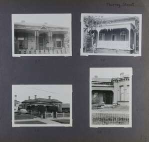
Album - Album page, Murray Street, Circa 1972
This photograph is part of the Caulfield Historical Album 1972. This album was created in approximately 1972 as part of a project by the Caulfield Historical Society to assist in identifying buildings worthy of preservation. The album is related to a Survey the Caulfield Historical Society developed in collaboration with the National Trust of Australia (Victoria) and Caulfield City Council to identify historic buildings within the City of Caulfield that warranted the protection of a National Trust Classification. Principal photographer thought to be Trevor Hart, member of Caulfield Historical Society. Most photographs were taken between 1966-1972 with a small number of photographs being older and from unknown sources. All photographs are black and white except where stated, with 386 photographs over 198 pages. Houses shown at 35, 58 and 32 Murray Street Elsternwick are still all extant (Google map image capture Dec 2018). Victorian Heritage Database - HO130 32 Murray Street Caulfield https://vhd.heritagecouncil.vic.gov.au/places/35535 (at 14/08/2021) No. 32 Murray Street is locally distinguished as the most imposing villa of its period in Murray Street whilst its association with J. W. Doyles, builder of several houses in the same street, is of interest. Its importance is enhanced by its substantially intact state.Page 138 of Photograph Album with four photographs (three landscape, one portrait) of 3 different houses on Murray Street. Handwritten: Murray Street [top right] / 35 [under top left photo] / 58 [under top right photo] / 32 [under bottom left photo] / 32 [under bottom right photo] / 138 [bottom right]trevor hart, garden, verandah, murray street, elsternwick, victorian style, houses, cast iron work, bay windows -
 Glen Eira Historical Society
Album - Album page, Murray Street, Circa 1972
This photograph is part of the Caulfield Historical Album 1972. This album was created in approximately 1972 as part of a project by the Caulfield Historical Society to assist in identifying buildings worthy of preservation. The album is related to a Survey the Caulfield Historical Society developed in collaboration with the National Trust of Australia (Victoria) and Caulfield City Council to identify historic buildings within the City of Caulfield that warranted the protection of a National Trust Classification. Principal photographer thought to be Trevor Hart, member of Caulfield Historical Society. Most photographs were taken between 1966-1972 with a small number of photographs being older and from unknown sources. All photographs are black and white except where stated, with 386 photographs over 198 pages. 63 and 117 Murray Street houses are extant (Google maps image capture Dec 2018).Victorian Heritage Database - HO131 63 Murray Street Caulfield https://vhd.heritagecouncil.vic.gov.au/places/35569 (as of 14/08/2021) "Marston" at no. 63 Murray Street, Caulfield South, was built by J.E. Guest, a contractor resident in nearby Downshire Road, in 1889-90, presumably as a speculative venture together with the extant house at adjoining No.61. It is aesthetically significant. It is aesthetically significant (Criterion E) as an exceptionally richly ornamented medium sized Boom period villa in Caulfield South, being unusual in this respect in its locale and comparing with nearby "Sprouston" at 19 Blanche Street (1887). Important contributory elements include the polychrome brickwork, frieze and verandah including the half timbered gablet which would have been stylistically innovative in its day.Page 139 of Photograph Album with two landscape photographs of two different houses in Murray Street. Handwritten: 63 MURRAY STREET [under top photo] / 117 MURRAY STREET [under bottom photo] / 139 [bottom left]trevor hart, garden, verandah, murray street, elsternwick, victorian style, houses, marston, house names, j e guest, verandahs, polychrome bricks, cast iron work, chimneys -
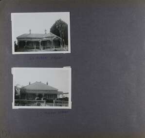
 Glen Eira Historical Society
Album - Album page, 31 Nepean Highway, Circa 1972
This photograph is part of the Caulfield Historical Album 1972. This album was created in approximately 1972 as part of a project by the Caulfield Historical Society to assist in identifying buildings worthy of preservation. The album is related to a Survey the Caulfield Historical Society developed in collaboration with the National Trust of Australia (Victoria) and Caulfield City Council to identify historic buildings within the City of Caulfield that warranted the protection of a National Trust Classification. Principal photographer thought to be Trevor Hart, member of Caulfield Historical Society. Most photographs were taken between 1966-1972 with a small number of photographs being older and from unknown sources. All photographs are black and white except where stated, with 386 photographs over 198 pages. Victorian Heritage Database - HO48 - 31 Nepean Highway Elsternwick https://vhd.heritagecouncil.vic.gov.au/places/35531 (at 15/08/2021) "Roseneath" at 31 Point Nepean Road is a bi-chromatic Italianate villa built for William Millar in 1874. It is aesthetically and historically important. "Roseneath's aesthetic value derives from its survival as a substantially intact bi-chromatic brick villa, distinguished by the symmetrical north and south facing bays and by its spacious grounds. Its historical value rests on its comparatively early date and link with Shire councillor William Millar. The choice of bi-chromatic brick, which was highly fashionable at the time, is also of note. "Roseneath" compares with "Cumbernauld" (pre 1872) at 504 Hawthorn Road and "Glenmoore" (1870) at 1 St Georges Road.Page 140 of Photograph Album with three (landscape) photographs of Roseneath on Nepean Highway. Handwritten: 31 Nepean Highway [top right] / 140 [bottom right]trevor hart, verandah, chimneys, porch, decorative brackets, single storey, cast iron columns, return verandah, garden, nepean highway, roseneath, italianate, 1870's, elsternwick, cast iron work, victorian style, polychrome bricks, william millar, slate roofs, brick houses, house names -
 Glen Eira Historical Society
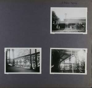
Album - Album page, Heatherbrae, 73 Neerim Road, Circa 1972
This photograph is part of the Caulfield Historical Album 1972. This album was created in approximately 1972 as part of a project by the Caulfield Historical Society to assist in identifying buildings worthy of preservation. The album is related to a Survey the Caulfield Historical Society developed in collaboration with the National Trust of Australia (Victoria) and Caulfield City Council to identify historic buildings within the City of Caulfield that warranted the protection of a National Trust Classification. Principal photographer thought to be Trevor Hart, member of Caulfield Historical Society. Most photographs were taken between 1966-1972 with a small number of photographs being older and from unknown sources. All photographs are black and white except where stated, with 386 photographs over 198 pages.From Victorian Heritage Database citation for Heatherbrae HO46 https://vhd.heritagecouncil.vic.gov.au/places/120933 (as at 28/10/2020) "Heatherbrae" at 73 Neerim Road, Glenhuntly, is a substantial Victorian residential complex made up of two principal construction stages (pre 1876 and c. 1890) and outbuildings including stables. It is aesthetically, historically and socially significant. Its aesthetic value is demonstrated by the manner in which the two periods of construction survive, the earliest being of greater architectural interest on account of its tower and facade treatment, the latter phase adopting a common villa form. The importance of the complex is heightened by its intact state and surviving outbuildings. "Heatherbrae's" historical significance lies in its link with locally known business man and Shire of Caulfield councillor, John Charles Holland. Its social value rests on its ability to demonstrate a past lifestyle.Page 142 of Photograph Album with four photographs (three landscape, one portrait) of Heatherbrae on Neerim Road.Handwritten: "Heatherbrae" 73 Neerim Road [top right] / 142 [bottom right]trevor hart, verandah, chimneys, decorative brackets, cast iron columns, return verandah, garden, 1870's, intricate lacework, neerim road, booran road, 1880's, 1890's, mansion, john c. holland, bluestone foundations, italianate, iron roofed balcony, cast iron balustrade, balcony, ornamented pediment, mosaic tiles, cast iron lookout, flagpole, george f griffiths, mcgowan, tower, caulfield, heatherbrae, cast iron work, victorian style, john holland, porte-cochere porches, lead lights, george griffiths, mansions, stables, councillors, outbuildings -
 Glen Eira Historical Society
Album - Album page, Heatherbrae, 73 Neerim Road, Circa 1972
This photograph is part of the Caulfield Historical Album 1972. This album was created in approximately 1972 as part of a project by the Caulfield Historical Society to assist in identifying buildings worthy of preservation. The album is related to a Survey the Caulfield Historical Society developed in collaboration with the National Trust of Australia (Victoria) and Caulfield City Council to identify historic buildings within the City of Caulfield that warranted the protection of a National Trust Classification. Principal photographer thought to be Trevor Hart, member of Caulfield Historical Society. Most photographs were taken between 1966-1972 with a small number of photographs being older and from unknown sources. All photographs are black and white except where stated, with 386 photographs over 198 pages.From Victorian Heritage Database citation for Heatherbrae HO46 https://vhd.heritagecouncil.vic.gov.au/places/120933 as at (28/10/2020) "Heatherbrae" at 73 Neerim Road, Glenhuntly, is a substantial Victorian residential complex made up of two principal construction stages (pre 1876 and c. 1890) and outbuildings including stables. It is aesthetically, historically and socially significant. Its aesthetic value is demonstrated by the manner in which the two periods of construction survive, the earliest being of greater architectural interest on account of its tower and facade treatment, the latter phase adopting a common villa form. The importance of the complex is heightened by its intact state and surviving outbuildings. "Heatherbrae's" historical significance lies in its link with locally known business man and Shire of Caulfield councillor, John Charles Holland. Its social value rests on its ability to demonstrate a past lifestyle. Page 143 of Photograph Album with 2 landscape photographs of Heatherbrae on Neerim Road - paving insignia and side view.Handwritten: "HEATHERBRAE" 73 NEERIM ROAD [top] / STABLE [under bottom photo] / 143 [bottom left]trevor hart, chimneys, cast iron columns, return verandah, garden, 1870's, neerim road, booran road, 1880's, 1890's, mansion, john c. holland, bluestone foundations, italianate, iron roofed balcony, cast iron balustrade, mosaic tiles, cast iron lookout, flagpole, george f griffiths, residential villa, caulfield, heatherbrae, victorian style, cast iron work, stables, outbuildings, john holland, george griffiths, councillors, mansions -
 Glen Eira Historical Society
Album - Album page, Neerim Road, Circa 1972
This photograph is part of the Caulfield Historical Album 1972. This album was created in approximately 1972 as part of a project by the Caulfield Historical Society to assist in identifying buildings worthy of preservation. The album is related to a Survey the Caulfield Historical Society developed in collaboration with the National Trust of Australia (Victoria) and Caulfield City Council to identify historic buildings within the City of Caulfield that warranted the protection of a National Trust Classification. Principal photographer thought to be Trevor Hart, member of Caulfield Historical Society. Most photographs were taken between 1966-1972 with a small number of photographs being older and from unknown sources. All photographs are black and white except where stated, with 386 photographs over 198 pages. "Edenkillie" was the home of Frederick Jowett, Caulfield's shire secretary and town clerk from 1887 to 1921. The Outer Circle Railway's Oakleigh section opened 1890 and closed 1895. Victorian Heritage database (as of 26/10/2021) HO45 Edenkillie https://vhd.heritagecouncil.vic.gov.au/places/35545 "Edenkillie" at 37 Neerim Road, Glenhuntly, is a substantial two storeyed polychrome brick villa, built for Frederick Jowett, municipal secretary, in 1890. It has aesthetic, historical and social significance. "Edenkillie's" aesthetic value derives from its survival as a substantially intact example of a common villa form expressed in polychrome brickwork. Its historical significance lies in its association with Frederick Jowett, Shire of Caulfield secretary and town clerk for over three decades. Its social significance is derived from the building's ability to demonstrate the kind of lifestyle which a local government administrator could enjoy during the Land Boom.Page 145 of Photograph Album with four landscape photographs from Neerim Road: two photographs of No 37 and two of the Outer Circle Railway Reserve.Handwritten: Neerim Road [top left] / 37 NEERIM ROAD 1OCT 1972 [under top left photo] / 37 NEERIM RD 1 OCT 1972 [under top right photo] / OUTER CIRCLE RAILWAY RESERVE MURRUMBEENA [under bottom left photo] / 145 [bottom left]trevor hart, neerim road, murrumbeena, caulfield, edenkillie, glen huntly, polychrome brick, mansions, frederick jowett, town clerks, shire of caulfield, outer circle railway, railways, parks and reserves, outer circle railway reserve, cast iron work, verandahs, balconies -
 Glen Eira Historical Society
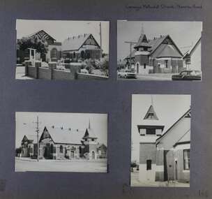
Album - Album page, Carnegie Methodist Church, Neerim Road, Circa 1972
This photograph is part of the Caulfield Historical Album 1972. This album was created in approximately 1972 as part of a project by the Caulfield Historical Society to assist in identifying buildings worthy of preservation. The album is related to a Survey the Caulfield Historical Society developed in collaboration with the National Trust of Australia (Victoria) and Caulfield City Council to identify historic buildings within the City of Caulfield that warranted the protection of a National Trust Classification. Principal photographer thought to be Trevor Hart, member of Caulfield Historical Society. Most photographs were taken between 1966-1972 with a small number of photographs being older and from unknown sources. All photographs are black and white except where stated, with 386 photographs over 198 pages. From Victorian Heritage Database citation for HO47 Uniting Church, 254 Neerim Road https://vhd.heritagecouncil.vic.gov.au/places/42432 (as at 28/10/2020) The former Methodist church (now Uniting church) complex at 252-54 Neerim Road, Carnegie, consists of the original timber church of 1886, the present brick Arts and Crafts influenced church of 1914, designed by A. Phipps Coles, the timber hall attached to the original church, built during the interwar period and the present brick hall of 1933, designed by J.F. Snell. From Victorian Heritage Database citation for HO47 Uniting Church, 254 Neerim Road https://vhd.heritagecouncil.vic.gov.au/places/42432 (as at 28/10/2020) The complex has aesthetic, historical and social significance. Its aesthetic value is derived from the extreme simplicity of the original church and the highly picturesque, eclectic, Arts and Crafts influenced character of the main church and hall. Its historical value rests in the early date of the original building and the manner in which the remaining buildings are representative of the principal period of settlement of the locality. The social significance derives from the use of the site as a place of worship since the commencement of the closer settlement of Carnegie from as early as 1886. Page 146 of Photograph Album with four photographs (3 landscape, 1 portrait) of Carnegie Methodist Church, Neerim Road.Handwritten: Carnegie Methodist Church Neerim Road [top right] / 146 [bottom right]trevor hart, neerim road, carnegie methodist church, church, toolambool road, wesleyan methodist church, breslin gallery, anthony breslin, 1910's, american romanesque, spire, half gabled tower, art, gallery, cafe, arched doorways, red brick, uniting church, carnegie, arts and craft style, a p coles, a coles, j f snell, j snell, halls -
 Glen Eira Historical Society
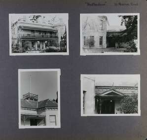
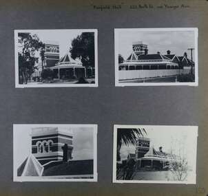
Album - Album page, Fairfield Hall, 225 North Road, Circa 1972
This photograph is part of the Caulfield Historical Album 1972. This album was created in approximately 1972 as part of a project by the Caulfield Historical Society to assist in identifying buildings worthy of preservation. The album is related to a Survey the Caulfield Historical Society developed in collaboration with the National Trust of Australia (Victoria) and Caulfield City Council to identify historic buildings within the City of Caulfield that warranted the protection of a National Trust Classification. Principal photographer thought to be Trevor Hart, member of Caulfield Historical Society. Most photographs were taken between 1966-1972 with a small number of photographs being older and from unknown sources. All photographs are black and white except where stated, with 386 photographs over 198 pages. Glen Eira Heritage Management Plan 1996 by Andrew Ward https://www.gleneira.vic.gov.au/media/4777/heritage_mment_plan_vol_3b.pdf (as of 27/01/2021) - p90 An imposing single storeyed Italianate bi-chromatic brick villa with three staged tower surmounting the entry and facetted corner bay with conical roof. White tuckpointed black body bricks are relieved with reds and stucco work. Gable ends are fretted and there is a concave cast iron verandah to the principal elevations.Victorian Heritage Database (as of 27/10/2020) - HO49 225 North Road Caulfield South https://vhd.heritagecouncil.vic.gov.au/places/42426 "Maniar" (?) is a substantial late Victorian Italianate villa with tower and extensive grounds built for Frederick Curwan, an inspector of the National Bank, in 1890. It is aesthetically and historically important. An imposing single storeyed ltalianate bi-chromatic brick villa with three staged tower surmounting the entry and facetted comer bay with conical roof. White tuckpointed black body bricks are relieved with reds and stucco work. Gable ends are fretted and there is a concave cast iron verandah to the principal elevations. It is aesthetically important as an imposing and substantially intact villa residence demonstrating the changing architectural fashions of the 1890's, evidenced by the use of face brickwork and fretted gables in the Queen Anne manner. It is historically important for the manner in which it demonstrates the lifestyle to which a businessman could aspire during the boom period.Page 150 of Photograph Album with four landscape photographs of Fairfield Hall on North Road.Handwritten: "Fairfield Hall" 225 North Rd cnr Younger Ave [top right] / 150 [bottom right]trevor hart, jenny o'donnell, verandah, porch, tower house, tower, mansion, three storey tower, bichromatic brickwork, fairfield hall, 1890's, george jobbins, conical roofed projecting corner bay, conical roofed bay, timber ceilings, north road, younger avenue, frederick wallis curwan, curwan, italianate, queen anne, australian homestead, arched windows, curved windows, columned parapet, return verandah, fairfield estate, fairfield street, slate roofed, red brick, polychrome bricks, victorian style, cast iron work, caulfield south, maniar, house names -
 Glen Eira Historical Society
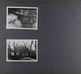
Album - Album page, 84 Orrong Crescent, Circa 1972
This photograph is part of the Caulfield Historical Album 1972. This album was created in approximately 1972 as part of a project by the Caulfield Historical Society to assist in identifying buildings worthy of preservation. The album is related to a Survey the Caulfield Historical Society developed in collaboration with the National Trust of Australia (Victoria) and Caulfield City Council to identify historic buildings within the City of Caulfield that warranted the protection of a National Trust Classification. Principal photographer thought to be Trevor Hart, member of Caulfield Historical Society. Most photographs were taken between 1966-1972 with a small number of photographs being older and from unknown sources. All photographs are black and white except where stated, with 386 photographs over 198 pages. From Victorian Heritage Database citation for 84 Orrong Crescent https://vhd.heritagecouncil.vic.gov.au/places/35584 as at (28/10/2020) "St. Reliers" at 84 Orrong Crescent is important as an unusually excessively enriched asymmetrical villa residence of the Boom period. From Victorian Heritage Database citation for HO50 84 Orrong Crescent Caulfield North https://vhd.heritagecouncil.vic.gov.au/places/35584 as at (28/10/2020) An imposing Italianate two storeyed asymmetrical villa with overpainted stuccoed surfaces to the facade, distinguished by their ornate treatment. Unusually rich ornamentation includes the acanthus leaf impost capitals, aedicules with swags and volutes, foliated panels to the frieze, ashlar treatment to the lower level and quoins above. The two storeyed cast iron verandah with timber frieze rail protects a black and white tiled floor. The hipped roof has patterned slates.Page 152 of Photograph Album with two landscape photographs of Bonhurst on Orrong Crescent.Handwritten: 84 Orrong Crescent [top right] / NOW 84 - PREVIOUSLY 120 ORRONG CRESCENT / "BONHURST" [under bottom photo] / 152 [bottom right]trevor hart, verandah, porch, slate roof, garden, decorative brackets, fanlight, protruding bay, bay window, garden lamp, asymmetrical, bonhurst, st reliers, rendered, orrong crescent, caulfield north, cast iron work, victorian style, mansions, house names, slate roofs, italianate style -
 Glen Eira Historical Society
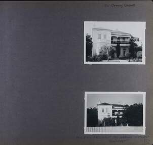
Album - Album page, Grimwade House, Orrong Road, Circa 1972
This photograph is part of the Caulfield Historical Album 1972. This album was created in approximately 1972 as part of a project by the Caulfield Historical Society to assist in identifying buildings worthy of preservation. The album is related to a Survey the Caulfield Historical Society developed in collaboration with the National Trust of Australia (Victoria) and Caulfield City Council to identify historic buildings within the City of Caulfield that warranted the protection of a National Trust Classification. Principal photographer thought to be Trevor Hart, member of Caulfield Historical Society. Most photographs were taken between 1966-1972 with a small number of photographs being older and from unknown sources. All photographs are black and white except where stated, with 386 photographs over 198 pages. From Victorian Heritage Database citation HO54 Grimwade House, former Harleston stables, outbuilding, garden, gate and Picconia excelsa tree. https://vhd.heritagecouncil.vic.gov.au/places/35573 as at (28/10/2020) ''Harleston'', now "Grimwade House", is situated at no. 67 Balaclava Road, Caulfield North, at the Orrong Road corner. It was built for Frederick, later Sir Frederick, Grimwade, to the design of architect Thomas Watts in 1875. Today the complex has been incorporated in the Melbourne Grammar Junior School campus. It retains not only the main house but also the stables and mature garden setting with driveway and gates. It is historically, aesthetically and socially significant.From Victorian Heritage Database citation HO54 Grimwade House, former Harleston stables, outbuilding, garden, gate and Picconia excelsa tree. https://vhd.heritagecouncil.vic.gov.au/places/35573 as at (28/10/2020) It is historically significant (Criterion A) as the former home of prominent business man, speculator and benefactor, Sir Frederick Grimwade. Both Grimwade and his house are exemplars of the commercial enterprise of the Boom period and the amassing of personal fortunes with which it is associated. It is aesthetically significant (Criterion E) as an imposing yet stately large house of its time, the classic Italian form with comer verandah terminated by projecting wings being most distinctively seen in this instance. It is enhanced not only by the garden setting but also by the delicate cast iron verandah spandrels, stained glass work and stencilled ceiling in the music room. It is socially significant (Criterion G) on account of the value placed on it by the community associated with the Melbourne Grammar Junior School since its inception on this site in 1911.Page 154 of Photograph Album with five photographs (4 landscape and one portrait) including Grimwade House, gates and a tram shelter.Handwritten: Grimwade House (Melbourne Grammar Prep School) / incorporating "Harleston" Orrong Rd. S.E cnr Balaclava Rd [top right] / 154 [bottom right]trevor hart, verandah, porch, slate roof, garden, grimwade house, grimwade, harleston, sir frederick grimwade, thomas watts, orrong road, balaclava road, melbourne grammar, melbourne grammar junior school, italianate, cast iron verandah spandrels, stained glass, stencilled ceiling, mgs, m.g.s, school, grimwade family, jessie grimwade, gates, palisade style fence, cast iron spears, stone plinths, melbourne grammar prep school, victorian style, cast iron work, caulfield north, gardens, cars, tram services, outbuildings, stables, trees, picconia excelsa tree -
 Glen Eira Historical Society
Album - Album page, Craigellachie, 273 Orrong Road, Circa 1972
This photograph is part of the Caulfield Historical Album 1972. This album was created in approximately 1972 as part of a project by the Caulfield Historical Society to assist in identifying buildings worthy of preservation. The album is related to a Survey the Caulfield Historical Society developed in collaboration with the National Trust of Australia (Victoria) and Caulfield City Council to identify historic buildings within the City of Caulfield that warranted the protection of a National Trust Classification. Principal photographer thought to be Trevor Hart, member of Caulfield Historical Society. Most photographs were taken between 1966-1972 with a small number of photographs being older and from unknown sources. All photographs are black and white except where stated, with 386 photographs over 198 pages. From Victorian Heritage Database citation HO40 Craigellachie 2b & 2c Lynedoch Avenue Caulfield North https://vhd.heritagecouncil.vic.gov.au/places/35209 as at (28/10/2020) Craigellachie" is situated at No. 2B Lynedoch Avenue, Caulfield North, and was built for the noted investor, pastoralist and politician, William Pearson, not earlier than 1864 and possible in 1876, undergoing several substantial and contributory extensions during the nineteenth century. It is historically and aesthetically significant. From Victorian Heritage Database citation for HO40 Craigellachie https://vhd.heritagecouncil.vic.gov.au/places/35209 as at (28/10/2020) It is historically significant (Criterion A) as the Melbourne home of William Pearson, MLA, MLC and principal shareholder in Walhalla's Long Tunnel Extended Gold Mining Co. which sustained the township well past the turn of the twentieth century and occupied fifth place amongst Victoria's richest mines. It is aesthetically significant (Criterion E) for its capacity to demonstrate Pearson's continuing financial success throughout the mid to late nineteenth century, the additions associated with the tower being most noteworthy as an example of the lasting appeal of the Italian Style, popularized in the pattern books of the day. The Ailanthus altissima (Tree of Heaven) is significant as an outstanding example of a species that is rare in cultivation, as well as for its very high aesthetic value. The Araucaria bidwilli is notable as a fine example of a species infrequently planted in Melbourne and rarely found in private suburban gardens.Page 156 of Photograph Album with four landscape photographs of Craigellachie - near views of architectural features. Handwritten: "Craigellachie" 273 Orrong Road [top right] / 156 [bottom right]trevor hart, verandah, orrong road, tower, curved windows, decorative brackets, italianate, mansion, 1870's, william pearson, inkerman street, apartments, spire, decorative plaster work, rendered walls, ornamentation, arched windows, moulded ornaments, 1860's, lynedoch avenue, classical style, caulfield north, craigellachie, cast iron work, victorian style, balaclava, st kilda east, gardens, ailanthus altissima, araucaria bidwilli, porches, trees -
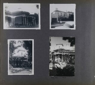 Glen Eira Historical Society
Album - Album page, Craigellachie, 273 Orrong Road, Circa 1972
This photograph is part of the Caulfield Historical Album 1972. This album was created in approximately 1972 as part of a project by the Caulfield Historical Society to assist in identifying buildings worthy of preservation. The album is related to a Survey the Caulfield Historical Society developed in collaboration with the National Trust of Australia (Victoria) and Caulfield City Council to identify historic buildings within the City of Caulfield that warranted the protection of a National Trust Classification. Principal photographer thought to be Trevor Hart, member of Caulfield Historical Society. Most photographs were taken between 1966-1972 with a small number of photographs being older and from unknown sources. All photographs are black and white except where stated, with 386 photographs over 198 pages. From Victorian Heritage Database citation for HO40 Craigellachie 2b & 2c Lynedoch Avenue Caulfield North https://vhd.heritagecouncil.vic.gov.au/places/35209 as at (28/10/2020) Craigellachie" is situated at No. 2B Lynedoch Avenue, Caulfield North, and was built for the noted investor, pastoralist and politician, William Pearson, not earlier than 1864 and possible in 1876, undergoing several substantial and contributory extensions during the nineteenth century. It is historically and aesthetically significant. From Victorian Heritage Database citation for HO40 Craigellachie https://vhd.heritagecouncil.vic.gov.au/places/35209 as at (28/10/2020) It is historically significant (Criterion A) as the Melbourne home of William Pearson, MLA, MLC and principal shareholder in Walhalla's Long Tunnel Extended Gold Mining Co. which sustained the township well past the turn of the twentieth century and occupied fifth place amongst Victoria's richest mines. It is aesthetically significant (Criterion E) for its capacity to demonstrate Pearson's continuing financial success throughout the mid to late nineteenth century, the additions associated with the tower being most noteworthy as an example of the lasting appeal of the Italian Style, popularized in the pattern books of the day. The Ailanthus altissima (Tree of Heaven) is significant as an outstanding example of a species that is rare in cultivation, as well as for its very high aesthetic value. The Araucaria bidwilli is notable as a fine example of a species infrequently planted in Melbourne and rarely found in private suburban gardens.Page 157 - four photographs of Craigellachie - exterior views. Handwritten: CRAIGELLACHIE [top left] / Neg 212 1973 [under bottom right photo] / 157 [bottom left]trevor hart, verandah, orrong road, tower, cast iron lacework, curved windows, decorative brackets, italianate, mansion, 1870's, william pearson, inkerman street, apartments, spire, decorative plaster work, rendered walls, arched windows, moulded ornaments, 1860's, lynedoch avenue, classical style, caulfield north, craigellachie, st kilda east, late victorian style, garages (private), gardens, cast iron work, ailanthus altissima, araucaria bidwilli, trees -
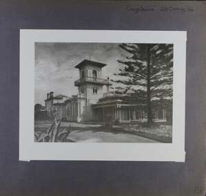 Glen Eira Historical Society
Album - Album page, Craigellachie, 273 Orrong Road, Circa 1972
This photograph is part of the Caulfield Historical Album 1972. This album was created in approximately 1972 as part of a project by the Caulfield Historical Society to assist in identifying buildings worthy of preservation. The album is related to a Survey the Caulfield Historical Society developed in collaboration with the National Trust of Australia (Victoria) and Caulfield City Council to identify historic buildings within the City of Caulfield that warranted the protection of a National Trust Classification. Principal photographer thought to be Trevor Hart, member of Caulfield Historical Society. Most photographs were taken between 1966-1972 with a small number of photographs being older and from unknown sources. All photographs are black and white except where stated, with 386 photographs over 198 pages. From Victorian Heritage Database citation for HO40 Craigellachie 2b & 2c Lynedoch Avenue Caulfield North https://vhd.heritagecouncil.vic.gov.au/places/35209 as at (28/10/2020) Craigellachie" is situated at No. 2B Lynedoch Avenue, Caulfield North, and was built for the noted investor, pastoralist and politician, William Pearson, not earlier than 1864 and possible in 1876, undergoing several substantial and contributory extensions during the nineteenth century. It is historically and aesthetically significant. From Victorian Heritage Database citation for HO40 Craigellachie https://vhd.heritagecouncil.vic.gov.au/places/35209 as at (28/10/2020) It is historically significant (Criterion A) as the Melbourne home of William Pearson, MLA, MLC and principal shareholder in Walhalla's Long Tunnel Extended Gold Mining Co. which sustained the township well past the turn of the twentieth century and occupied fifth place amongst Victoria's richest mines. It is aesthetically significant (Criterion E) for its capacity to demonstrate Pearson's continuing financial success throughout the mid to late nineteenth century, the additions associated with the tower being most noteworthy as an example of the lasting appeal of the Italian Style, popularized in the pattern books of the day. The Ailanthus altissima (Tree of Heaven) is significant as an outstanding example of a species that is rare in cultivation, as well as for its very high aesthetic value. The Araucaria bidwilli is notable as a fine example of a species infrequently planted in Melbourne and rarely found in private suburban gardens.Page 158 of Photograph Album with one image of Craigellachie's exterior. Handwritten: "Craigellachie" 273 Orrong Road [top right] / 158 [bottom right]trevor hart, verandah, orrong road, tower, curved windows, decorative brackets, rendered, craigellache, italianate, mansion, 1870's, william pearson, inkerman street, apartments, spire, decorative plaster work, rendered walls, ornamentation, arched windows, moulded ornaments, 1860's, lynedoch avenue, classical style, caulfield north, craigellachie, land subdivision, gardens, late victorian style, cast iron work, st kilda east, ailanthus altissima, araucaria bidwilli, trees -
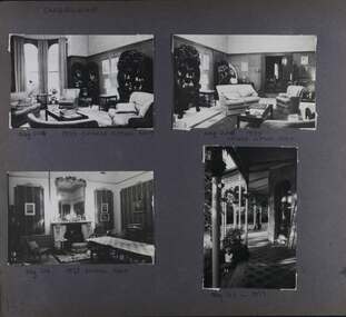 Glen Eira Historical Society
Album - Album page, Craigellachie, 273 Orrong Road, Circa 1972
This photograph is part of the Caulfield Historical Album 1972. This album was created in approximately 1972 as part of a project by the Caulfield Historical Society to assist in identifying buildings worthy of preservation. The album is related to a Survey the Caulfield Historical Society developed in collaboration with the National Trust of Australia (Victoria) and Caulfield City Council to identify historic buildings within the City of Caulfield that warranted the protection of a National Trust Classification. Principal photographer thought to be Trevor Hart, member of Caulfield Historical Society. Most photographs were taken between 1966-1972 with a small number of photographs being older and from unknown sources. All photographs are black and white except where stated, with 386 photographs over 198 pages. From Victorian Heritage Database citation for HO40 Craigellachie 2b & 2c Lynedoch Avenue Caulfield North https://vhd.heritagecouncil.vic.gov.au/places/35209 as at (28/10/2020) Craigellachie" is situated at No. 2B Lynedoch Avenue, Caulfield North, and was built for the noted investor, pastoralist and politician, William Pearson, not earlier than 1864 and possible in 1876, undergoing several substantial and contributory extensions during the nineteenth century. It is historically and aesthetically significant. From Victorian Heritage Database citation for HO40 Craigellachie https://vhd.heritagecouncil.vic.gov.au/places/35209 as at (28/10/2020) It is historically significant (Criterion A) as the Melbourne home of William Pearson, MLA, MLC and principal shareholder in Walhalla's Long Tunnel Extended Gold Mining Co. which sustained the township well past the turn of the twentieth century and occupied fifth place amongst Victoria's richest mines. It is aesthetically significant (Criterion E) for its capacity to demonstrate Pearson's continuing financial success throughout the mid to late nineteenth century, the additions associated with the tower being most noteworthy as an example of the lasting appeal of the Italian Style, popularized in the pattern books of the day. The Ailanthus altissima (Tree of Heaven) is significant as an outstanding example of a species that is rare in cultivation, as well as for its very high aesthetic value. The Araucaria bidwilli is notable as a fine example of a species infrequently planted in Melbourne and rarely found in private suburban gardens.Page 159 - four photographs of Craigellachie - three room interiors and along the verandah. Handwritten: CRAIGELLACHIE [top left] / Neg 224 1973 CHINESE SITTING ROOM [under top right photo] / Neg 226 1973 / CHINESE SITTING ROOM [under top right photo] / Neg 214 1973 DINING ROOM [under bottom left photo] / Neg 213 - 1973 [under bottom right photo] / 159 [bottom left]trevor hart, verandah, orrong road, tower, curved windows, decorative brackets, craigellache, italianate, mansion, 1870's, william pearson, inkerman street, apartments, spire, decorative plaster work, rendered walls, arched windows, moulded ornaments, 1860's, lynedoch avenue, classical style, caulfield north, craigellachie, land subdivision, gardens, late victorian style, cast iron work, st kilda east, dining rooms, sitting rooms, furnishings, tiles -
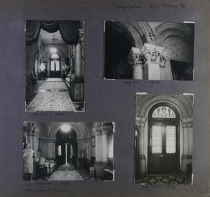 Glen Eira Historical Society
Album - Album page, Craigellachie, 273 Orrong Road, Circa 1972
This photograph is part of the Caulfield Historical Album 1972. This album was created in approximately 1972 as part of a project by the Caulfield Historical Society to assist in identifying buildings worthy of preservation. The album is related to a Survey the Caulfield Historical Society developed in collaboration with the National Trust of Australia (Victoria) and Caulfield City Council to identify historic buildings within the City of Caulfield that warranted the protection of a National Trust Classification. Principal photographer thought to be Trevor Hart, member of Caulfield Historical Society. Most photographs were taken between 1966-1972 with a small number of photographs being older and from unknown sources. All photographs are black and white except where stated, with 386 photographs over 198 pages. From Victorian Heritage Database citation for HO40 Craigellachie 2b & 2c Lynedoch Avenue Caulfield North https://vhd.heritagecouncil.vic.gov.au/places/35209 as at (28/10/2020) Craigellachie" is situated at No. 2B Lynedoch Avenue, Caulfield North, and was built for the noted investor, pastoralist and politician, William Pearson, not earlier than 1864 and possible in 1876, undergoing several substantial and contributory extensions during the nineteenth century. It is historically and aesthetically significant.From Victorian Heritage Database citation for HO40 Craigellachie https://vhd.heritagecouncil.vic.gov.au/places/35209 as at (28/10/2020) It is historically significant (Criterion A) as the Melbourne home of William Pearson, MLA, MLC and principal shareholder in Walhalla's Long Tunnel Extended Gold Mining Co. which sustained the township well past the turn of the twentieth century and occupied fifth place amongst Victoria's richest mines. It is aesthetically significant (Criterion E) for its capacity to demonstrate Pearson's continuing financial success throughout the mid to late nineteenth century, the additions associated with the tower being most noteworthy as an example of the lasting appeal of the Italian Style, popularized in the pattern books of the day. The Ailanthus altissima (Tree of Heaven) is significant as an outstanding example of a species that is rare in cultivation, as well as for its very high aesthetic value. The Araucaria bidwilli is notable as a fine example of a species infrequently planted in Melbourne and rarely found in private suburban gardens.Page 160 - four photographs of Craigellachie interiors. Handwritten: "Craigellachie" 273 Orrong Road [top right] / 156 [bottom right]trevor hart, orrong road, italianate, mansion, 1870's, william pearson, inkerman street, decorative plaster work, rendered walls, ornamentation, moulded ornaments, 1860's, lynedoch avenue, classical style, caulfield north, craigellachie, late victorian style, st kilda east, hallways, arched doors, stained glass, mrs francis, furnishings -
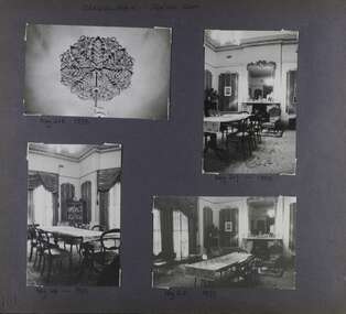 Glen Eira Historical Society
Album - Album page, Craigellachie, 273 Orrong Road, Circa 1972
This photograph is part of the Caulfield Historical Album 1972. This album was created in approximately 1972 as part of a project by the Caulfield Historical Society to assist in identifying buildings worthy of preservation. The album is related to a Survey the Caulfield Historical Society developed in collaboration with the National Trust of Australia (Victoria) and Caulfield City Council to identify historic buildings within the City of Caulfield that warranted the protection of a National Trust Classification. Principal photographer thought to be Trevor Hart, member of Caulfield Historical Society. Most photographs were taken between 1966-1972 with a small number of photographs being older and from unknown sources. All photographs are black and white except where stated, with 386 photographs over 198 pages. From Victorian Heritage Database citation for HO40 Craigellachie 2b & 2c Lynedoch Avenue Caulfield North https://vhd.heritagecouncil.vic.gov.au/places/35209 as at (28/10/2020) Craigellachie" is situated at No. 2B Lynedoch Avenue, Caulfield North, and was built for the noted investor, pastoralist and politician, William Pearson, not earlier than 1864 and possible in 1876, undergoing several substantial and contributory extensions during the nineteenth century. It is historically and aesthetically significant. From Victorian Heritage Database citation for HO40 Craigellachie https://vhd.heritagecouncil.vic.gov.au/places/35209 as at (28/10/2020) It is historically significant (Criterion A) as the Melbourne home of William Pearson, MLA, MLC and principal shareholder in Walhalla's Long Tunnel Extended Gold Mining Co. which sustained the township well past the turn of the twentieth century and occupied fifth place amongst Victoria's richest mines. It is aesthetically significant (Criterion E) for its capacity to demonstrate Pearson's continuing financial success throughout the mid to late nineteenth century, the additions associated with the tower being most noteworthy as an example of the lasting appeal of the Italian Style, popularized in the pattern books of the day. The Ailanthus altissima (Tree of Heaven) is significant as an outstanding example of a species that is rare in cultivation, as well as for its very high aesthetic value. The Araucaria bidwilli is notable as a fine example of a species infrequently planted in Melbourne and rarely found in private suburban gardens.Page 161 - four photographs of Craigellachie dining room Handwritten: CRAIGELLACHIE DINING ROOM [top left] / Neg 218 1973 [under top left photo] / Neg 217 - 1973 [under top right photo] / Neg 216- 1973 [under bottom left photo] / Neg 215 1973 [under bottom right photo] / 161 [bottom left]trevor hart, orrong road, curved windows, italianate, mansion, 1870's, william pearson, inkerman street, decorative plaster work, rendered walls, moulded ornaments, 1860's, lynedoch avenue, classical style, caulfield north, craigellachie, land subdivision, late victorian style, dining rooms, ceiling roses, furnishings, fireplaces, st kilda east