Showing 672 items
matching junction road
-
 Coal Creek Community Park & Museum
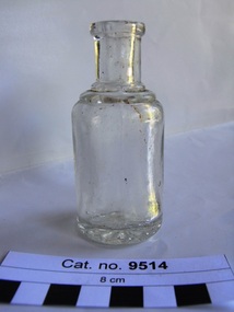
Bottle, glass
Round thick clear glass bottle with rounded glass rings at junction of neck and body of bottle. Pattern embossed on base.A 'daisy' flower pattern embossed in base. -
 Coal Creek Community Park & Museum
Glass Bottle
Small clear (with green tint) square glass bottleWM Johnson & Son Chemists. Junction St Kilda. -
 St Kilda Historical Society
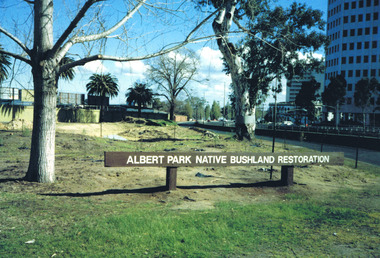
Photograph, Albert Park Native Bushland Restoration Project 1991 - images collection
The bushland area near the Corroborree Tree, near the corner of Fitzroy Street St Kilda and the Queens Road offramp from St Kilda Road, was restored in 1991 by Earthcare.Colour photographsst kilda junction, corroboree tree, albert park native bushland, 1991, earthcare, ngargee tree, james williams, albert park -
 St Kilda Historical Society
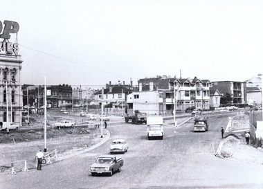
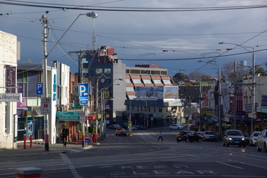
Photograph, St Kilda Junction Reconstruction - images collection
... Road Colour photographs St Kilda Junction Reconstruction ...Colour photographsst kilda junction, trams, st kilda road -
 St Kilda Historical Society
Photograph, St kilda Junction Construction Barkly Street, c. 1968
black and white matt photograph good condition unmountedhandwritten on back: High St (St Kilda Road) left and Barkly Street, right. Detours opened to traffic. Photo filed 27.3.1968. Copyright. This photograph may not be reproduced without permission in writing from the Editor of "The Age". 250 Spencer Street, Melbourne and 39/41 York st, Sydney. -
 St Kilda Historical Society
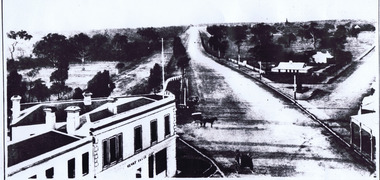
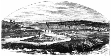
Photograph, St Kilda Junction with Old Police Paddock, c. 1858
on back: St Kilda Junction showing old police paddock and canoe tree? Date unknown, but before bitumen surfacing of roads -- pre 1900? Copy courtesy LaTrobe Library, Melbourne Handwritten: about 1858copy of(?) black and white photograph fair condition unmountedSt Kilda Junction showing old police paddock and canoe tree? Date unknown, but before bitumen surfacing of roads -- pre 1900? Copy courtesy LaTrobe Library, Melbourne Handwritten: about 1858 -
 St Kilda Historical Society
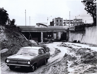
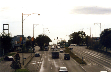
Photograph, Queens Rd underpass, St Kilda Junction, 18/08/1968, c. 1968
... Queen's Road underpass, St Kilda Junction. Photo filed... underpass, St Kilda Junction Photo filed 18.8.1968 Queen's Road ...hand written on back: Queens Rd underpass, St Kilda Junction Photo filed 18.8.1968black and white matt photograph good condition unmountedQueen's Road underpass, St Kilda Junction. Photo filed 18.8.1968. H71. V 13120. Copyright. This photograph may not be reproduced without permission in writing from the Editor of "The Age". 250 Spencer Street, Melbourne and 39/41 York st, Sydney. -
 Puffing Billy Railway
Rail Bender No. 3
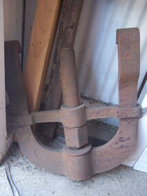
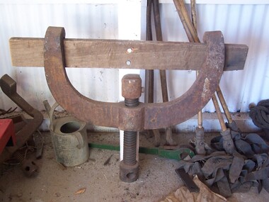
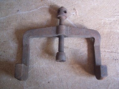
Rail Bender - Part of Hydraulic Rail Bender Rail Bender – No. 3 Most rails are produced straight. While they to easily bend and appear flexible, they are required to bend for some curves, at rail joins on curves and at point (turn-out) junctions. For a safe transition around curves and in the finer areas of the point, this use to be done with a manual rail bender. Sometimes referred to as a Buddah, the rail bender attaches its two claws to the rail. In the middle of the two claws is a screw that is tightened slowly using large spanner. Historic - Railways Permanent Way and Works - track equipment - Rail Bender large Rail Bender - Part of Hydraulic Rail Bender made of cast wrought iron puffing billy, rail bender -
 Puffing Billy Railway
Bender - Light Rail
Light Rail Bender Most rails are produced straight. While they to easily bend and appear flexible, they are required to bend for some curves, at rail joins on curves and at point (turn-out) junctions. For a safe transition around curves and in the finer areas of the point, this use to be done with a manual rail bender. Sometimes referred to as a Buddah, the rail bender attaches its two claws to the rail. In the middle of the two claws is a screw that is slowly tightened using a crow-bar to bend the rail. Tightening the screw too fast or too tightly may not give the structure of the rail time to redistribute and the rail may break if not done properly. Historic - Railways Permanent Way and Works - track equipment - Light Rail Bender Light Rail Bender made out of cast wrought ironpuffing billy, light rail bender -
 Puffing Billy Railway
Tool - Rail bender
Railway tracks are produced straight. They may appear to be easy to bend and may appear flexible, but are required to be bent for curves, at rail joins on curves and at point (turn-out) junctions. For a safe transition around curves and in the finer areas of the point, this was required to be done with a manual rail bender. Sometimes referred to as a Jim Crow, the rail bender attaches its two claws to the rail. In the middle of the two claws is a screw that is slowly tightened using a crow-bar to bend the rail. Tightening the screw too fast or too tightly may not give the structure of the rail time to redistribute and the rail may break if not done properly.Victorian Railways Permanent Way and Works track equipment Light Rail Bender narrow GaugeCast iron semi-circular tool, with hooked ends and central screw shaft.puffing billy, rail bender, jim crow -
 Lake Bolac & District Historical Society
Colour photograph, Lake Bolac township. 1963
Crossroads at Lake Bolac, 1963. Junction of the Ballarat/Hamilton and Ararat/Mortlake roads. Starting centre left, the large building on the south-east side of the Ballarat road is Goodall's garage. Next door is the original Bush Nursing centre, then Dalgety's, the Bakery, the Milkbar and on the corner is the Bank of New South Wales building, Elder's, Green's drapery shop and the Lake Bolac Memorial Hall. On the traffic island in front of the Hall is the War Memorial and across the Woorndoo road is the Hotel (with the maroon roof) with stables behind. Across the road again is the Stanbury's General Store with their large warehouse behind.lake bolac, 1963, goodall, bush nursing, dalgety, elders, green, bank of new south wales, stanbury. -
 Sunshine and District Historical Society Incorporated
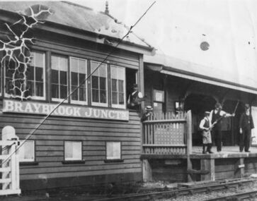
Photograph (1905), BRAYBROOK JUNCTION STATION
The Braybrook Junction railway station was opened on 7th September 1885 at the junction of the railway lines to Ballarat and to Bendigo. In 1904 H. V. McKay purchased the Braybrook Implement Works nearby, and in 1906 he moved his Sunshine Harvester Works agricultural machinery business from Ballarat to Braybrook Junction. In 1907 the station and township were renamed Sunshine after the Sunshine Harvester Works. On 20 April 1908 (Easter Monday), Sunshine station was the scene of the biggest train disaster in Victoria, when 44 people were killed and 400 injured from the 1100 people that were aboard the two trains. A Melbourne bound train from Bendigo collided with the rear of a train from Ballarat. There is a memorial plaque on platform 1 at the present Sunshine station. Sunshine station has recently been undergoing a complete rebuild. On 20 January 2014 the station, although not yet completed, was opened for train use, after being closed for several weeks.This photograph is significant because it is a reminder that the present Sunshine station and the nearby area were once named Braybrook Junction. It also shows what the Station, the Signal Box, and the station personnel looked like in circa 1905.Monochrome photograph showing Braybrook Junction Station and the Signal Box, plus station personnel. One of the personnel is holding a 'Staff' which was actually the authority for the train to proceed to the next Station or Signal Box. Photograph has substantial crazing in the upper left corner, a long diagonal crease, and dog eared corners.BRAYBROOK JUNCTNbraybrook junction station, railway, sunshine, train, transport, 1905, 1907, 1908, 7 september 1885 -
Clunes Museum
Financial record - PHOTOCOPIED LEDGER ENTRIES, John Spark Leather Ledger dated 1870's
130 PHOTOCOPIED PAGES FROM A SMALL LEATHER LEDGER -1872-1873-1874 &1875 owned by John Spark who later had a butcher Shop at 27 Fraser Street. Likely to be his droving recordsJOHN SPARK THE JUNCTION - written on front. The Junction referring to his property on the road to Maryborough. local history, books, accounts, spark's butcher shop -
 Plutarch Project
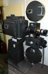
35mm Projector, circa 1950's
This 35mm Westrex 14 projector was purchased from Waverley Theatre (Cnr Burke Road and Waverley Road in Malvern, in 1962) last used by "Cosmopolitan Motion Pictures" as follows: from 1962 to 1967 - National Theatre, Richmond. from 1967 to 1970 - in a small leatherette on Bridge Road, Richmond. from 1971 to 1985 - Galaxy Theatre Brunswick. After that it was stored at the back of Westgarth Theatre in Northcote. This projector has a primary historic significance as it covers the largest part of the history of film shows by "Cosmopolitan Motion Pictures", and cultural/social significance since it has been used to project a number of other language films (about 10 different languages) by the company. It also carries a secondary significance of rarity being the last used projector by the company at Galaxy Theatre.This metal (most probably steel) projector is part of a number of projectors owned by "Cosmopolitan Motion Pictures". It is in dark blue/grey colour and still operational to project 35mm films if needed. It has two inscriptions detailed below and was last used at Liberty/Galaxy Theatre in Brunswick in 1985 (for more details about the history of Galaxy Theatre follow this link http://technicolouryawn.com/?page_id=2988)INSCRIPTION 1 (red background) Westrex 14, High Intensity Arc Lamp, Serial Number A.5401018. Manufactured for Westrex (Australia) Pty. Limited by G.B.H. Electronic Laboratories - Made in N.S.W. Australia INSCRIPTION 2 (blue background) Westrex R4A Reproducer Made in Australia Western Electric Co. (Aust) Pty. Ltd.projector, film, culture, language, greek, entertainment, γιαννούδης, yiannoudes, προβολέας -
Whitehorse Historical Society Inc.
Map, Victorian Railways, Blackburn to Ringwood, 1919
Schematic plan of rail line with notes of all signals and junctions. Signed by Gus. Ballard, Chief Engineer of Ways of Works.Schematic plan of rail line with notes of all signals and junctions. Signed by Gus. Ballard, Chief Engineer of Ways of Works.Schematic plan of rail line with notes of all signals and junctions. Signed by Gus. Ballard, Chief Engineer of Ways of Works.victorian railways, blackburn railway station, tunstall railway station, nunawading railway station, mitcham railway station, ringwood railway station -
Whitehorse Historical Society Inc.
Document, History of Burwood East State School, 1/03/1969
Document on Burwood East Primary School, originally a non-vested school, no 184 Harkaway, located at the junction of Highbury and Blackburn Roads whose first building was erected in 1861.burwood east primary school no. 454, nunawading common school no 454 -
Whitehorse Historical Society Inc.
Article, The Track from Rugby Junction to Nunawading, 1999
Early career in the UK of Joan Roczniok.Early career in the UK of Joan Roczniok, her arrival in 1964 in Australia, work in various libraries and work with the Nunawading & District Historical SocietyEarly career in the UK of Joan Roczniok.nunawading & district historical society, libraries, roczniok, joan -
 Whitehorse Historical Society Inc.
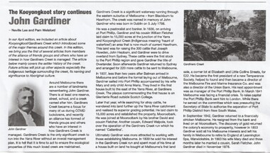
Article - John Gardiner, 23/06/2021
John Gardiner was born in Dublin 1798. He was a pastoralist and banker and arrived at Port Phillip in 1836 and with his cousin William Fletcher laid claim to 15,000 acres at the junction of the Yarra River and Kooyongkoot CreekJohn Gardiner was born in Dublin 1798. He was a pastoralist and banker and arrived at Port Phillip in 1836 and with his cousin William Fletcher laid claim to 15,000 acres at the junction of the Yarra and Kooyongkoot Creek.non-fictionJohn Gardiner was born in Dublin 1798. He was a pastoralist and banker and arrived at Port Phillip in 1836 and with his cousin William Fletcher laid claim to 15,000 acres at the junction of the Yarra River and Kooyongkoot Creekgardiner john, gardiners creek -
 Ballarat Heritage Services
Digital photographs, fiveways (Denmark, Studley Park, Princess, High, High South) from Kew Junction (Cotham and High), c2017
Digital images of Kew Junction.kew, kew junction, five ways, streetscape, cotham road, high street, road, shop, shopping centre, strip shopping centre, commercial -
 Ballarat Heritage Services
Photograph - Image, Guildford, Victoria, 1867
Black and white image of Guildford, near Castlemaine, VictoriaGUILDFORD Is a small township situated at the junction of Campbell's Creek and the Loddon. It is about seven miles from Castlemaine, on the road from that town to Ballaarat and Daylesford. The land near the Loddon is very rich, and as a large number both of theoretical and practical miners believe that a rich goldfield underlies the surface basalt, there is every probability of Guildford being ere an important goldfield. A large area of land in the neighbourhood has been already worked, principaIy by Chinamen, who until very recently mustered in great force in the locality. (Illustrated Adelaide Post, 23 March 1867)guildford, loddon river -
 Whitehorse Historical Society Inc.
Photograph, Whitehorse Road, Mitcham
Coloured photograph of Whitehorse Road, Mitcham. Lights are at the junction of Whitehorse and Mitcham Roads and traffic on left is heading east towards Ringwood. Church on the left is the Mitcham Anglican Church, which is on the corner of Whitehorse Road and Edwards Street.whitehorse road, mitcham -
 Whitehorse Historical Society Inc.
Photograph, Chapel Street, Blackburn, 2012
Coloured photographs of shops on the north-west corner of the junction of Railway Parade and Chapel Street, Blackburn, Post Office on the opposite corner.chapel street, blackburn, shops, shopping -
 Whitehorse Historical Society Inc.
Photograph, Vermont Primary School
In 1872, pupils began the school year in the building. By 1958 a new site opened in Nurlendi Road, Vermont. After standing derelict for many years, the old Vermont Primary School was moved to the Nurlendi site in 1992Coloured photo of Vermont Primary School No.1022 on the original site on the north-west corner of the junction of Mitcham and Canterbury Roads.vermont primary school no.1022, primary schools -
 Whitehorse Historical Society Inc.
Photograph, Mitcham Hotel 1954
Originally called the Reserve Hotel; built in 1895Black and white photograph and negative of the Mitcham Hotel taken in 1954 from the north-west corner of the junction of Mitcham and Whitehorse Roads (Note early introduction of traffic lights)mitcham hotel, mitcham road, mitcham, whitehorse road, reserve hotel, byrne's -
 Mt Dandenong & District Historical Society Inc.
Photograph, View Up Valley At Kalorama
John Lundy-Clarke grew up in the Kalorama/Mt Dandenong area and later in life (1972-74) began to write a comprehensive history of the area working from an original settlement map in an effort to cover all areas. The building in the centre of the photograph is 'Kia-Ora' guest house. Situated on Barber’s Road, ‘Kia-Ora’ was built in 1912 by George Barber. It was later leased by a Mrs Pemberthy. “Kia-Ora’ was one of four places connected when the telephone was brought into the district in 1912. The other places were ‘Mountjoy’, ‘Cherry Farm’ and ‘Callum House’. ‘Kia-Ora’ was burnt down in 1924. Black and White copy of section of a Rose Series postcard. Shows view up the valley at Kalorama with a decorative building centre middle of photograph. Handwritten description by John Lundy-Clarke on reverse.View up valley at Kalorama from near junction of Barbers and Doughty’s Rds. “Kia Ora” guest house in centre. Paynter’s “Iona” top left with “Kalorama” to its right. About 1912. Rose Series copied by JLC 1973.kalorama, kalorama valley, john lundy-clarke, barbers road, george barber, kia-ora, guest house, iona -
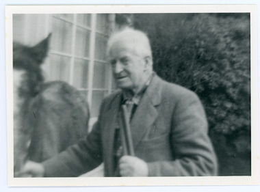 Mt Dandenong & District Historical Society Inc.
Photograph, Edward John Price 1973
John Lundy-Clarke grew up in the Kalorama/Mt Dandenong area and later in life (1972-74) began to write a comprehensive history of the district working from an original settlement map in an effort to cover all areas. Edward John Price (Ted)(1899-1974) was the third child of Edward Joseph and Annie Price. He lived a very industrious life in the area. When the new CRB road cut through the family land Edward John established a Corn and Produce store on a level area adjoining the new road . Along with his brother Charlie, Ted took up road contracting and formed Grange Road in 1923. They also took up contracts to metal the CRB road between The Gap and Olinda. Edward John married Myra Wilson in 1930. They lived in the first brick home built in the district. They had two sons, Edward Joseph 2nd and Alan.Black and white photograph showing an old man dressed in a jacket holding the reins of a horse. Reverse of photograph has handwritten description by John Lundy-Clarke.Edward John Price 1973. Son of Edward Joseph & Annie Ada nee Ross. Born 1899 died 1974. Farmer, Carrier, Sawmiller, Contractor, Quarry Owner, Shop Proprietor (Kew Junction 1935). Father of Alan & Edward J.edward john price, myra wilson, edward joseph price, annie price, alan price, charles price, grange road, crb road -
 Magnet Galleries Melbourne Inc
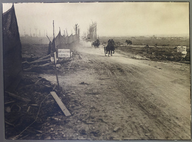
hellfire corner, hellfire corner.tif
Hellfire Corner was a junction in the Ypres Salient in the First World War. The main supplies for the British Army in this sector passed along the road from Ypres to Menin - the famous Menin Road. A section of the road was where the Sint-Jan-Zillebeke road and the Ypres-Roulers railway line crossed the road. The German Army positions overlooked this spot and their guns were registered upon it so that movement through this junction was perilous, making it the most dangerous place in the sector.hellfire corner, ypres salient, war, road, ww1, world war 1 -
 Ballarat Tramway Museum
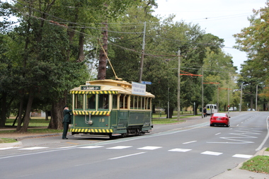
Photograph - Digital Image, Peter Knife, BTM Tram 18 Depot Junction, 19/4/2014
Set of three colour images of BTM tram 18 running in at the end of an operating day. The first image shows the driver at the rear of the tramcar and the next two of the tram crossing Wendouree Parade into the depot. This location was rebuilt during November and December 2014 and the road moved to the west for bicycle safety. Photo by Peter Knife 19/4/2014.Yields information about Ballarat Tramway Museum operations in Wendouree Parade and tram 18Set of three Digital images of colour slides.tramways, tramcars, btm, wendouree parade., depot junction, tram 18 -
 Ballarat Tramway Museum
Slide - 27 mm sq slide/s - set of 11, Lilian Butler, Wendouree Parade and Sturt St West, Sep. 1971
Yields information about the streetscapes of Ballarat depot to Pleasant St route and in particular buildings and people that crewed the trams.Set of eleven Colour 27 x 27 mm slide in a Kodachrome cardboard mount. .1 - Wendouree Parade looking west towards St Aidans Drive - the gate pillars can be seen. .2 - ditto looking west - Fairyland .3 - ditto looking towards Gardens Loop .4 - No. 41 at Gardens Loop, with destination of Gardens via Drummond North .5 - ditto showing Mt Pleasant .6 - ditto, just past the now BTM Depot Junction. .7 - Carlton St - showing the gates .8 - Looking towards Hamilton Ave from within Carlton St loop with the signal showing red. .9 - Turning from Hamilton Ave into Sturt St West. .10 - Sturt St west looking east with the Loreto convent walls on the left hand side. .11 - Sturt St - Pleasant St intersection - showing road surface, a tram coming towards the intersection and buildings on either side. Slide mount date September 1971. Photo from the collection of Lilian Butler.ballarat, tramways, trams, wendouree parade, st aidans drive, gardens loop, depot junction, carlton st, carlton st loop, signals, sturt st west, pleasant st, tram 41 -
 Ballarat Tramway Museum
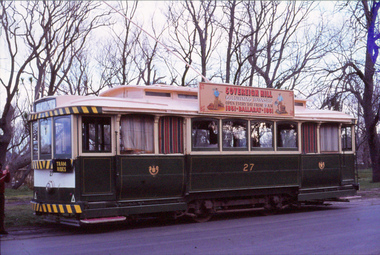
Slide - 35mm slide/s - set 16, John Theodore, 15/10/1978 12:00:00 AM
Yields information about the official opening by the BTPS of its operations in Wendouree Parade at the time of the 1978 AGM and the building extensions.Set of 16 AGFA blue and white plastic mount 35mm slides of the 1978 AGM at the depot and tram operations in Wendouree Parade - 15/10/1978 (September 1978 Fares Please!) .1 - 27 at St Aidans Drive .2 - ditto with a Sovereign Hill roof Advert .3 - ditto .4 - ditto at Carlton St .5 - ditto .6 - 27 arriving Depot Junction - note the signal lamp .7 - ditto .8 - looking up the access track .9 - Building extension works underway 10 - ditto showing the pits .11 - showing the stockpile of gravel .12 - 1978 AGM in progress - note the landscaping .13 - ditto .14 - 27 on the 3 road extension .15 - 40 and 27 at the depot fan .16 - depot fan and 27. Various notations by John as to the slide number and the trams in pencil and ink.tramways, trams, btps, wendouree parade, meetings, depot, buildings, tram 40, tram 27