Showing 785 items matching "murray river"
-
 Wodonga & District Historical Society Inc
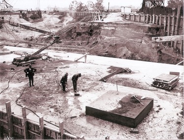
Album - Hume Reservoir Australia Album - Preparing a paddock for concrete. August 1927
... River Murray Waters Scheme...DEPARTMENT OF PUBLIC WORKS, N.S.W. RIVER MURRAY WATERS... OF PUBLIC WORKS, N.S.W. RIVER MURRAY WATERS SCHEME. HUME RESERVOIR ...This set of photos is from a leather bound album bearing the inscription "HUME RESERVOIR AUSTRALIA" plus 'The Rt. Hon. L. C. M. S. Amery, P. C., M .P.' all inscribed in gold. It was presented to The Rt. Hon. L. C. M. S. Amery, P. C., M. P, Secretary of State for Dominion Affairs on the occasion of his visit to the Hume Reservoir on 2nd November 1927. This album is of local and national significance as it documents the planning and development of the Hume Reservoir up to 1927. It was the largest water reservoir in the British Empire. The album records the pioneering engineering work that went into its construction.DEPARTMENT OF PUBLIC WORKS, N.S.W. RIVER MURRAY WATERS SCHEME. HUME RESERVOIR. 27. Preparing a Paddock for Concrete. Great care is taken in cleaning the surface of the concrete before placing the next layer. A hose applies a jet of water with a pressure of about 150 pounds to remove laitance and all dirt, which is swept off with brooms. (Laitance is the weak, milky or powdery layer of cement dust, lime and sand fines that appear on the surface of concrete. ) The square block of concrete in the foreground is poured at the same time as the concrete surrounding it and acts as a key for the next layer. Usually large granite “plums” or displacers weighing from 2 tons to 8 tons are used for this purpose and are placed in position by the cableway, but while the cableway is out of action the other method has been adopted. In this view may also be seen some of the timber piles and sheeting which form the inner side of the coffer dam. The outer side is formed of steel sheet piling. The space between the two lines of piles is 20 feet wide and is filled with earth after the steel and timber lines have been bound together by steel tie rods. New South Wales, August 1927.hume reservoir australia, river murray waters scheme, hume reservoir construction -
 Port of Echuca
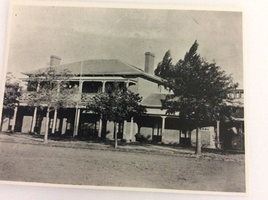
A black and white photograph, The Bridge Hotel, in 1896, showing Silky Oak trees, 1970's
... visitors to the town crossing the Murray River on his punt crossing... to the town crossing the Murray River on his punt crossing, which ...The Bridge Hotel was built by Henry Hopwood to house visitors to the town crossing the Murray River on his punt crossing, which was situated just below the Bridge Hotel on the Murray River. The accommodation was spacious and grand! In the right back corner of the photograph, the 'lantern' roof of the St Georges Hall can be seen. The street is level with the front entrance to the Hotel, which is very different to what it is today.The photograph shows hotel activities and accommodation in the late 19th Century.A black and white photograph of the Bridge Hotel taken from the Hopwood Gardens. The photograph shows four silky oak trees growing along the front of the building. There is an empty flag pole outside the front of the building. The right wing advertises billiards, whilst the left wing apparently was a bar.Written on the building can be seen the words; HOTEL and BILLIARDS. Written in pen on the back of the photograph are the words "Bridge Hotel. Probably 1896, showing Silky Oak trees.bridge hotel, henry hopwood, silky oak trees, lantern roof, st georges hotel -
 Bendigo Historical Society Inc.
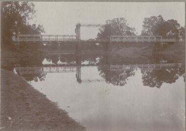
Photograph - BRIDGE - SINGLE SPAN
... over Murray River ? On front rop right corner Mp 107... photo on grey board: single span lift bridge across river. Long ...sepia photo on grey board: single span lift bridge across river. Long truss spans each side of lift section. Probably over Murray River ? On front rop right corner Mp 107. On back written ' copies obtainable from M. Clifton, Koondrook'M. Clifton ?bridge, construction, single span lift bridge -
 Eltham District Historical Society Inc
Photograph, George Coop, Steam plant of paddle steamer 'Adelaide' at Echuca, c.1962
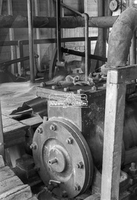
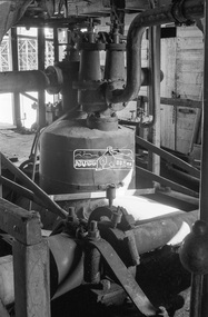
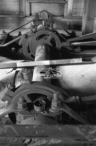
... and returned to the Murray River.... and returned to the Murray River. George Coop Collection Echuca Paddle ...PS 'Adelaide' was later turned into a display in the park surrounded by rose bushes for around 20 years before being restored and returned to the Murray River.Digital TIFF file Scan of 35mm Ilford FP3 black and white negative transparencygeorge coop collection, echuca, paddle steamer, ps adelaide, steam engine -
 Eltham District Historical Society Inc
Photograph, George Coop, Steam plant of paddle steamer 'Adelaide' at Echuca, c.1962
... and returned to the Murray River.... and returned to the Murray River. George Coop Collection Echuca Paddle ...PS 'Adelaide' was later turned into a display in the park surrounded by rose bushes for around 20 years before being restored and returned to the Murray River.Digital TIFF file Scan of 35mm Ilford FP3 black and white negative transparencygeorge coop collection, echuca, paddle steamer, ps adelaide, steam engine -
 Tatura Irrigation & Wartime Camps Museum
Photograph - copy, Sir Ronald East
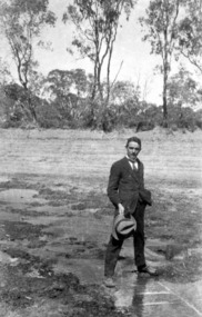
... East as a young man astride the Murray River near Nyah, during.... Sir Ronald East as a young man astride the Murray River near ...Original photo borrowed by Museum for copying. Sir Ronald East as a young man astride the Murray River near Nyah, during drought year -
 Wodonga & District Historical Society Inc
Album - Hume Reservoir Australia Album - General View of Works from New South Wales end, Looking Upstream, August 1927
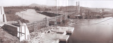
... River Murray Waters Scheme...DEPARTMENT OF PUBLIC WORKS, N.S.W. RIVER MURRAY WATERS... OF PUBLIC WORKS, N.S.W. RIVER MURRAY WATERS SCHEME. HUME RESERVOIR ...This set of photos is from a leather bound album bearing the inscription "HUME RESERVOIR AUSTRALIA" plus 'The Rt. Hon. L. C. M. S. Amery, P. C., M .P.' all inscribed in gold. It was presented to The Rt. Hon. L. C. M. S. Amery, P. C., M. P, Secretary of State for Dominion Affairs on the occasion of his visit to the Hume Reservoir on 2nd November 1927. This album is of local and national significance as it documents the planning and development of the Hume Reservoir up to 1927. It was the largest water reservoir in the British Empire. The album records the pioneering engineering work that went into its construction.DEPARTMENT OF PUBLIC WORKS, N.S.W. RIVER MURRAY WATERS SCHEME. HUME RESERVOIR. 22. General View of Works from New South Wales end, Looking Upstream. Features: At the left, part of the North Wing Wall, the highest part of which is 26 feet below its ultimate height. Below in the foreground is the portion of the dam where provision is to be made for hydro-electric generation. The tubes, three in number, 13 feet in diameter, will be laid on the level shown and an early start will be made in laying them. The level for the other four regulating outlets, 9 feet in diameter, together with a part of the spillway section of the dam, is underwater at this stage and it may be remarked that at one point, about half way across the channel where the water is now flowing, the concrete foundations are about 80 feet below the level of the water. The broken surface of the water is due to the large “plums” in the concrete. The still water in the right foreground is the stilling pool over the concrete floor of which there is now more than 20 feet of water and by means of which the discharge from the outlet pipes will be quelled. The trestlework on the upstream side of the dam carries the concrete belt conveyor. It extends from the concrete mixer house, which is out of the picture, behind the wing wall, along almost the entire length of the concrete portion of the dam. The concrete is discharged from the belt at any desired point by means of trippers, one of which may be seen over the second trestle. On the other side of the flowing water is the coffer dam. A channel 300 feet wide involving about 140,000 cubic yards of excavation and dug for the temporary diversion of the river as it is flowing now. To the right top of the view beyond the Coffer Dam is the earth embankment being thrown across the major part of the valley by the Victorian Constructing Authority. The Mitta Mitta River flows into the Murray at the far end of the reach of water on the left. August 1927.hume reservoir australia, river murray waters scheme, hume reservoir construction -
 Yarrawonga and Mulwala Pioneer Museum
Memorabilia - Yarrawonga Rifle club trophy, 1950
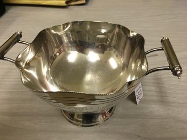
... Sloanes Mulwala station on the Murray River. I D Forbes... Sloanes Mulwala station on the Murray River. I D Forbes ...Ollie Meritan was the manager for Whiteheads who bought Sloanes Mulwala station on the Murray River. I D Forbes was the Weir Manager at the time and a member of the rifle clubSilver sugar basin. Round bowl with petal shaped edges on a small stand. It has two handles attachedYarrawonga rifle club 1950. Donated by O. Meritan won by I D Forbes -
 Department of Energy, Environment and Climate Action
Fire patrol launch
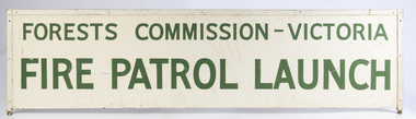
... boats on the Gippsland Lakes, Lake Eildon and the Murray River... boats on the Gippsland Lakes, Lake Eildon and the Murray River ...The Forests Commission once had a flotilla of small fire boats on the Gippsland Lakes, Lake Eildon and the Murray River which were used for fire patrol and suppression.Fire patrol launch signforests commission victoria (fcv), bushfire, forest signs -
 Wodonga & District Historical Society Inc
Album - Hume Reservoir Australia Album - Detail plan and explanation, Department of Public Works, N.S.W, 1927
... River Murray Waters Scheme... Authority for that State under the River Murray Waters Agreement... Authority for that State under the River Murray Waters Agreement ...This set of photos is from a leather bound album bearing the inscription "HUME RESERVOIR AUSTRALIA" plus 'The Rt. Hon. L. C. M. S. Amery, P. C., M .P.' all inscribed in gold. It was presented to The Rt. Hon. L. C. M. S. Amery, P. C., M. P, Secretary of State for Dominion Affairs on the occasion of his visit to the Hume Reservoir on 2nd November 1927. This album is of local and national significance as it documents the planning and development of the Hume Reservoir up to 1927. It was the largest water reservoir in the British Empire. The album records the pioneering engineering work that went into its construction.2. Detail Plan and Section. Starting from the New South Wales and there will be an earthen embankment 430 feet 6 inches long which is retained by the North Wing Wall. Then come the sluice section 284 feet 3 inches long, the spillway 720 feet long and the South Wing Wall, making a total length of 1,042 feet 6 inches of concrete wall. Beyond the South Wing Wall is earth embankment again to a length of 3,827 feet. The Full Supply Level is R.L.626.00 and allowance has been made for a surcharge of 9 feet. A road will run along the top of the dam at R.L.642.00. The sluice section contains seven offlets, the three nearest the north wing wall being 13 feet in diameter for hydro-electric purposes and the other four 9 feet in diameter for regulation purposes only. There are to be stony sluice gates on the upstream ends of the outlets and needle valves on the downstream ends. The shock of the discharged water will be taken by a stilling pool. Trash racks will protect the intake ends of the outlets. Next comes the spillway section, which is curved on the downstream face, and carried up to within 15 feet of the full supply level. Above that will be a series of piers between which will be the flood gates and on top of which the roadway will be carried. The gates will be 20 feet wide and 15 feet high and will be 29 in number. They will slide down the face of the wall when opened for the escape of the water. The investigation of the control of this cascade of water was made by means of a model and as a result the form of “bucket” or energy dissipater shown on the section of the spillway was decided upon. The earth embankment in Victoria is being constructed by the State Rivers and Water Supply Commission of Victoria who are the Constructing Authority for that State under the River Murray Waters Agreement. The core of the embankment is of concrete 6 feet wide at the base tapering to 2 feet at the top end and is reinforced with steel rods from the level of the decomposed rock upwards. On the downstream side, at about natural surface level, is a tunnel for drainage and inspection purposes. Above the tunnel is a vertical layer of large stones to drain any seepage to the tunnel. Against the core wall is packed selected material of as impervious a character as can be got locally and beyond that the bank is carefully built up in horizontal layers by means of horses and wheel scoops. The upstream slope is 3-to-1 hardening to 2½-to-1 at the top and the downstream slope is 2½-to-1 hardening to 2.07-to-1 at the top. The thrust of the upstream toe is taken by a mass of granite blocks, and this face is protected by concrete laid in situ. The width of the bank at base is 650 feet and at top 32 feet.hume reservoir australia, river murray waters scheme, hume weir diagrams, hume plan details -
 Eltham District Historical Society Inc
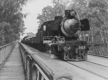
Photograph, George Coop, Steam locomotive J-507 hauling a goods train from Echuca (Vic.), Aug. 1963, Aug. 1963
... (Vic.) crosses the Iron Bridge over the Murray River bound... (Vic.) crosses the Iron Bridge over the Murray River bound ...Steam locomotive J-507 hauling a goods train from Echuca (Vic.) crosses the Iron Bridge over the Murray River bound for Moama (NSW), August 1963Digital TIFF file Scan of black and white print Enlargement prints on textured paper (15.5 x 20.5 cm)george coop collection, echuca, echuca-moama road rail bridge, j-507, j-class steam locomotive (vulcan foundry) -
 Bendigo Historical Society Inc.
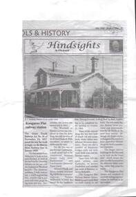
Newspaper - RAILWAYS COLLECTION: KANGAROO FLAT RAILWAY STATION BY KEN ARNOLD
... of the page.A small article describing history of the Murray River line... of the Murray River line beginning in 1859 and the Kangaroo Flat railway ...Railways Collection -Foolscap Article on Kangaroo Flat railway station 'Hindsights' by Ken Arnold dated May 2002 -Break o'Day. There is a photo of the railway station including the two storey Station Masters house 'In an earlier time' on the top of the page.A small article describing history of the Murray River line beginning in 1859 and the Kangaroo Flat railway.Ken Arnoldnewspaper -
 Wodonga & District Historical Society Inc
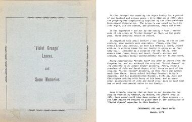
Booklet - Collection of Local History Booklets, Rosemary Boyes B.E.M
... are:- 1. "Violet Grange Leneva" and its History 2. Albury - Murray..." and its History 2. Albury - Murray River to Botanic Gardens 3 ...In 1976 Rosemary Boyes was awarded the British Empire Medal for services to Australian History. She was the author of more than 20 publications about local and national historical events. From 1970 to 1981, writing as Mrs Frank Boyes, she contributed a regular column to the Wodonga/Albury Express newspaper. Rosemary was a Founder Member of the Albury & District Historical Society in 1961, a Life Member of Wodonga & District Historical Society and also a Life Member of the Wodonga RSL Sub-Branch. She and her husband, Frank, a veteran of the Kokoda Trail, farmed at Leneva before moving to Albury and then to Frankston. Rosemary Boyes died in September 1991.A collection of small paper back booklets on a range of topics related to Albury and Wodonga history. Their titles are:- 1. "Violet Grange Leneva" and its History 2. Albury - Murray River to Botanic Gardens 3. The Hume Highway - A potpourri of Stories and Scenes, Today and Yesterday 4. The Hume Monument - Albury NSW 5. Remembering Robert BrownIn 1976 Rosemary Boyes was awarded the British Empire Medal for services to Australian History. She was the author of more than 20 publications about local and national historical events. From 1970 to 1981, writing as Mrs Frank Boyes, she contributed a regular column to the Wodonga/Albury Express newspaper. Rosemary was a Founder Member of the Albury & District Historical Society in 1961, a Life Member of Wodonga & District Historical Society and also a Life Member of the Wodonga RSL Sub-Branch. She and her husband, Frank, a veteran of the Kokoda Trail, farmed at Leneva before moving to Albury and then to Frankston. Rosemary Boyes died in September 1991. australian history, rosemary boyes bem -
 Port of Echuca
Colour photograph, Approx.1979
... to it ) moored to the wharf structure on the Murray river at Echuca... to the wharf structure on the Murray river at Echuca. Punts were used ...This photograph shows a punt (with a dingy tied to it ) moored to the wharf structure on the Murray river at Echuca. Punts were used to transport people and goods from one side of the river to the other.Punts were used to cross the Murray river at many spots before bridges were built. Henry Hopwood set up his initial business with punts across the Murray and Campaspe rivers, charging people, animals and vehicles to cross the rivers.Colour photograph of a punt tied to the port structure, seen through the foliage of gums on the river bank.On reverse:" This paper manufactured by Kodak"port of echuca, hopwood's punt, echuca, port of -
 Port of Echuca
Work on paper - PS Corrong
... on back views of Wharf at Echuca River Murray... at Echuca River Murray black and white photo with color border Work ...Historic View of Wharf from Wetdock. black and white photo with color borderon back views of Wharf at Echuca River Murray -
 Rutherglen Historical Society
Image, 7/05/2013
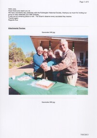
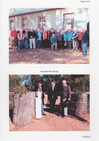
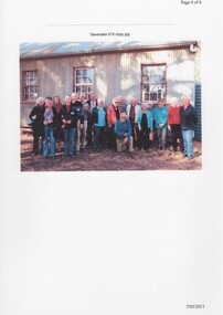
... , on the Murray River at Yarrawonga...., on the Murray River at Yarrawonga. savenake station historical society ...On 6/05/2013 members and guests of the Rutherglen Historical Society visited Savenake Station, which is a working historic pastoral property, 20 minutes north of Lake Mulwala, on the Murray River at Yarrawonga.Page 1 of an email with colour photographs, printed on A4 photographic paper.savenake station, historical society activities, heritage properties -
 Rutherglen Historical Society
Image, 7/05/2013
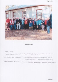
... , on the Murray River at Yarrawonga...., on the Murray River at Yarrawonga. savenake station historical society ...On 6/05/2013 members and guests of the Rutherglen Historical Society visited Savenake Station, which is a working historic pastoral property, 20 minutes north of Lake Mulwala, on the Murray River at Yarrawonga.Page 2 of an email with colour photographs, printed on A4 photographic paper.Names of persons in photograph have been handwritten below photographsavenake station, historical society activities, heritage properties -
 Rutherglen Historical Society
Image, 7/05/2013
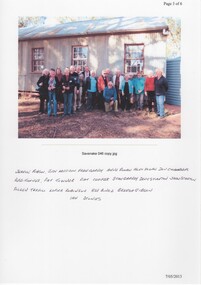
... , on the Murray River at Yarrawonga...., on the Murray River at Yarrawonga. savenake station historical society ...On 6/05/2013 members and guests of the Rutherglen Historical Society visited Savenake Station, which is a working historic pastoral property, 20 minutes north of Lake Mulwala, on the Murray River at Yarrawonga.Page 3 of an email with colour photographs, printed on A4 photographic paper.Names of persons in photograph have been handwritten below photographsavenake station, historical society activities, heritage properties -
 Rutherglen Historical Society
Image, 7/05/2013
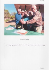
... , on the Murray River at Yarrawonga...., on the Murray River at Yarrawonga. savenake station historical society ...On 6/05/2013 members and guests of the Rutherglen Historical Society visited Savenake Station, which is a working historic pastoral property, 20 minutes north of Lake Mulwala, on the Murray River at Yarrawonga.Page 4 of an email with colour photographs, printed on A4 photographic paper.Names of persons in photograph have been handwritten below photographsavenake station, historical society activities, heritage properties -
 Rutherglen Historical Society
Image, 7/05/2013
... , on the Murray River at Yarrawonga...., on the Murray River at Yarrawonga. savenake station historical society ...On 6/05/2013 members and guests of the Rutherglen Historical Society visited Savenake Station, which is a working historic pastoral property, 20 minutes north of Lake Mulwala, on the Murray River at Yarrawonga.Page 5 of an email with colour photographs, printed on A4 photographic paper.savenake station, historical society activities, heritage properties -
 Rutherglen Historical Society
Image, 7/05/2013
... , on the Murray River at Yarrawonga...., on the Murray River at Yarrawonga. savenake station historical society ...On 6/05/2013 members and guests of the Rutherglen Historical Society visited Savenake Station, which is a working historic pastoral property, 20 minutes north of Lake Mulwala, on the Murray River at Yarrawonga.Page 6 of an email with colour photographs, printed on A4 photographic paper.savenake station, historical society activities, heritage properties -
 Tatura Irrigation & Wartime Camps Museum
Print - Framed Picture, Ulrich Laufer, Hut 6
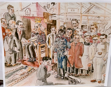
... . He was a trained commercial artist. He drowned in the Murray.... He was a trained commercial artist. He drowned in the Murray ...Ulrich Laufer was born to a Jewish family in Berlin in 1923. He was a trained commercial artist. He drowned in the Murray River while on active service as a member of the 8th employment company AMF in 1943. Framed copy of pen, ink and water colour cartoon of camp inmates of Hut 6 dressed in different costumes. Frame black/brown wood with gold edge.ulrich laufer, camp artists, 8th employment co., dunera, 1943, amf -
 Bendigo Historical Society Inc.
Photograph - BLACK AND WHITE PHOTOGRAPH OF MURRAY'S PASS GULLY MARYSVILLE
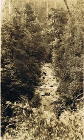
... Black and white photograph of Murray's Pass, aggerty River... PHOTOGRAPH Landscape Black and white photograph of Murray's Pass ...Black and white photograph of Murray's Pass, aggerty River, Marysville, 1924-25.photograph, landscape -
 Marysville & District Historical Society
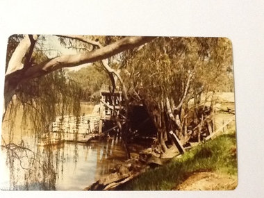
Postcard (Item) - Colour tinted postcard, Murray Views, Murray Views No. 51. The Water Wheel, Marysville, Vic, 1950
... barton water wheel steavenson river murray views murray views ...A digital copy of a colour tinted postcard of the water wheel that powered the Barton's Store in Marysville in Victoria.A digital copy of a colour tinted postcard of the water wheel that powered the Barton's Store in Marysville in Victoria. This water wheel was located on the Steavenson River in Marysville. Barton's Store was established by Thomas John Barton in 1864. Thomas John Barton was born in 1836 in Gloucestershire and after his father died in 1850 arrived in Melbourne in 1852 along with his mother, adult sisters, younger brothers, his uncle, his uncle's wife Suzanna and their family. Thomas tried gold mining at Woods Point but found it too difficult. He then partnered with Ewen Hugh Cameron to provide the miners with meat. In 1864 they purchased a plot of land in Marysville and set up a butchers/abattoirs and from there began their business of taking supplies to the miners at the nearby Woods Point and Jamieson goldfields. In 1865 the business was firmly established and Thomas married Selina Croker at Heidelberg and brought her back to Marysville. Their first home was 'The Chestnuts', which included the store, and was situated on the town side next to the Steavenson River. Sadly, in 1876 Selina died of complications after giving birth to their sixth child. Thomas was in need of a nanny to care for his six children, including the newborn baby, and so he employed Emily Ada Sparke, who is the eldest daughter of the local school teacher. Thomas and Emily subsequently marry in 1878 and they go on to have a further 10 children over the next several years. Thomas assisted in the establishment of the first school in Marysville in 1870 and remained a very active member of the community including as a Councillor for the Shire of Healesville, Shire President and he was also appointed as a Justice of the Peace. Thomas died in Carlton in 1911. After their father's death, his sons Fred and Frank took over the family business, which was then known as Barton Bros Store which continued to operate until sometime in the 1970's. This postcard was produced by Murray Views in 1950 as a souvenir of Marysville.marysville, victoria, barton's store, thomas john barton, ewen hugh cameron, woods point, jamieson, gold mining, goldfields, selina croker, the chestnuts, emily ada sparke, shire of healesville, fred barton, frank barton, barton bros store, francis adam barton, frederick john barton, water wheel, steavenson river, murray views, murray views no. 51, postcard, souvenir -
 Wodonga & District Historical Society Inc
Album - Hume Reservoir Australia Album - Dedication, Department of Public Works, N.S.W, 1927
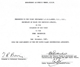
... River Murray Waters Scheme... that went into its construction. Hume Reservoir Australia River ...This set of photos is from a leather bound album bearing the inscription "HUME RESERVOIR AUSTRALIA" plus 'The Rt. Hon. L. C. M. S. Amery, P. C., M .P.' all inscribed in gold. It was presented to The Rt. Hon. L. C. M. S. Amery, P. C., M. P, Secretary of State for Dominion Affairs on the occasion of his visit to the Hume Reservoir on 2nd November 1927. To ensure preservation of the album and its contents, the images and information pages have all been digitised. It is assumed that over the past 70 to 80 years there has been some loss of contrast due to fading, and probably detail. Thus, each photo was enhanced in several steps. Digitalisation of the album was completed by Eric Eulenstein in Wodonga in April 2002. The position of Secretary of State for Dominion Affairs was a British cabinet-level position created in 1925 and responsible for British relations with the Dominions — Canada, Australia, New Zealand, South Africa, Newfoundland, and the Irish Free State — and the self-governing Crown colony of Southern Rhodesia.This album is of local and national significance as it documents the planning and development of the Hume Reservoir up to 1927. It was the largest water reservoir in the British Empire. The album records the pioneering engineering work that went into its construction. Hume Reservoir Australia Album - Dedication page recording the presentation of the album to 'The Rt. Hon. L. C. M. S. Amery, P. C., M.P" and his visit to Albury in 1927. “DEPARTMENT OF PUBLIC WORKS, N.S.W./ PRESENTED TO THE RIGHT HONOURABLE L.C.M.S. AMERY, F.C., M.P.,/ SECRETARY OF STATE FOR DOMINION AFFAIRS/ on the/ OCCASION OF HIS VISIT/ to the /HUME RESERVOIR/ on/ 2ND NOVEMBER 1927, /WITH THE COMPLIMENTS OF THE NEW SOUTH WALES CONSTRUCTING AUTHORITY./(SIGNED) T.R. BAVIN, Premier & Colonial Treasurer./ E.A. BATTENSHAW, Minister for Public Works & Railways and Constructing Authority for New South Wales/ C. TYLE, Under Secretary for Public Works”hume reservoir australia, river murray waters scheme -
 Wodonga & District Historical Society Inc
Album - Hume Reservoir Australia Album - Introduction - Part 2, Department of Public Works, N.S.W, 1927
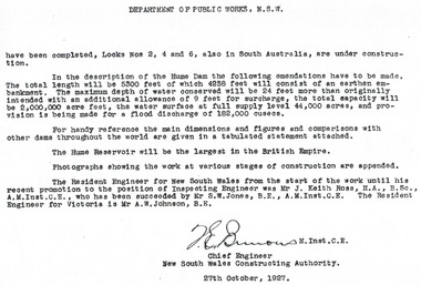
... River Murray Waters Scheme... that went into its construction. Hume Reservoir Australia River ...This set of photos is from a leather bound album bearing the inscription "HUME RESERVOIR AUSTRALIA" plus 'The Rt. Hon. L. C. M. S. Amery, P. C., M .P.' all inscribed in gold. It was presented to The Rt. Hon. L. C. M. S. Amery, P. C., M. P, Secretary of State for Dominion Affairs on the occasion of his visit to the Hume Reservoir on 2nd November 1927. This album is of local and national significance as it documents the planning and development of the Hume Reservoir up to 1927. It was the largest water reservoir in the British Empire. The album records the pioneering engineering work that went into its construction.DEPARTMENT OF PUBLIC WORKS, N.S.W. (continued from previous image). have been completed, Locks Nos. 2, 4 and 6, also in South Australia, are under construction. In the description of the Hume Dam the following emendations have to be made. The total length will be 5,300 feet of which 4,258 feet will consist of an earthen embankment. The maximum depth of water conserved will be 24 feet more than originally intended with an additional allowance of 9 feet for surcharge, the total capacity will be 2,000,000 acre feet, the water surface at full supply level 44,000 acres, and provision is being made for a flood discharge of 182,000 cusecs. For handy reference, the main dimensions and figures and comparisons with other dams throughout the world are given in a tabulated statement attached. The Hume Reservoir will be the largest in the British Empire. Photographs showing the work at various stages of construction are appended. The Resident Engineer for New South Wales from the start of the work until his recent promotion to the position of Inspecting Engineer was Mr J. Keith Ross, M.A., B.Sc., A.M.Inst.C.E., who has been succeeded by Mr S.W. Jones, B.E., A.M.Inst.C.E. The Resident Engineer for Victoria is Mr A.W. Johnson, B.E. (Signed) M. Inst.C.E. Chief Engineer New South Wales Constructing Authority 27th October 1927. hume reservoir australia, river murray waters scheme -
 Wodonga & District Historical Society Inc
Album - Hume Reservoir Australia Album - Dimensions of Hume Reservoir, Department of Public Works, N.S.W, 1927
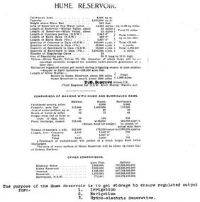
... River Murray Waters Scheme... that went into its construction. Hume Reservoir Australia River ...This set of photos is from a leather bound album bearing the inscription "HUME RESERVOIR AUSTRALIA" plus 'The Rt. Hon. L. C. M. S. Amery, P. C., M .P.' all inscribed in gold. It was presented to The Rt. Hon. L. C. M. S. Amery, P. C., M. P, Secretary of State for Dominion Affairs on the occasion of his visit to the Hume Reservoir on 2nd November 1927. This album is of local and national significance as it documents the planning and development of the Hume Reservoir up to 1927. It was the largest water reservoir in the British Empire. The album records the pioneering engineering work that went into its construction.Table outlining the Dimensions of the Hume Weir and comparisons with MAKWAR and BURRINJUCK DAMS, and some other comparisons. MAKWAR Dam is located on the Blue Nile about five miles south of Sennar and 175 miles south of Khartoum in Sudan. The construction of this dam started in 1922 and was completed in May 1925, while the British Empire colonised Sudan. It was officially opened on 21st January 1926. The BURRINJUCK DAM is situated in the upper catchment of the Murrumbidgee River, approximately 60 kms from Yass, N.S.W. It was built from 1907 to 1927 The stated purpose of the Hume Reservoir is to get storage to ensure regulated output for:- 1. Irrigation 2. Navigation 3. Hydro-electric Generation.hume reservoir australia, river murray waters scheme, hume dimensions -
 Wodonga & District Historical Society Inc
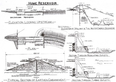
Album - Hume Reservoir Australia Album - Hume Reservoir Detailed diagrams, Department of Public Works, N.S.W, 1927
... River Murray Waters Scheme... that went into its construction. Hume Reservoir Australia River ...This set of photos is from a leather bound album bearing the inscription "HUME RESERVOIR AUSTRALIA" plus 'The Rt. Hon. L. C. M. S. Amery, P. C., M .P.' all inscribed in gold. It was presented to The Rt. Hon. L. C. M. S. Amery, P. C., M. P, Secretary of State for Dominion Affairs on the occasion of his visit to the Hume Reservoir on 2nd November 1927. This album is of local and national significance as it documents the planning and development of the Hume Reservoir up to 1927. It was the largest water reservoir in the British Empire. The album records the pioneering engineering work that went into its construction.6 Diagrams showing the details of the Hume Reservoir structure. On the left from the top of the page to bottom are:- ELEVATION LOOKING UPSTREAM, PLAN aTYPICAL SECTION OF EARTHEN EMBANKMENT. ' On the right from top to bottom are:- SECTIONAL - ELEVATION OF SPILLWAY & TAIL WATER ENERGY DISSIPATOR, SECTION THROUGH REGULATING OUTLETS and SECTION THROUGH TURBINE OUTLETS.hume reservoir australia, river murray waters scheme, hume weir diagrams, hume plan details