Showing 11365 items
matching on the map
-
 Whitehorse Historical Society Inc.
Map, Nunawading Planning Scheme. Local Section, 1993
Map of City of Nunawading.Map of City of Nunawading showing zoning of areas by means of colours and some detailed designations. Note: ' This map contains amendments as at 14 Oct 1993'Map of City of Nunawading.city of nunawading, maps, land use -
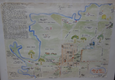
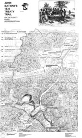 Greensborough Historical Society
Map, Dennis Ward, John Batman's 1835 Treaty Trail on the Plenty River, 2010_
Map of the Plenty River through Greensborough and surrounding areas, annotated with historic places. Prepared by Dennis Ward, this map shows places of interest with historic markers for a proposed Heritage Trail along the Plenty. This was a joint project of Dennis Ward, Rotary Greensborough and Nillumbik Historical Society.This map shows many places of interest along the Plenty River. Large laminated map, including land subdivisions and street names.plenty river heritage trail -
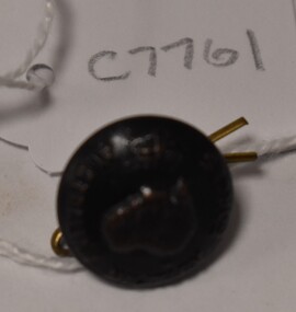
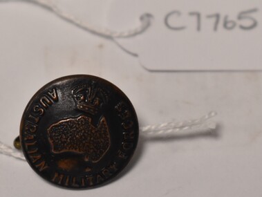 Tatura Irrigation & Wartime Camps Museum
Button, K C Luke Pty Ltd
Issued to Sister Kathleen Heaphy of Australian Army Nursing service. Sister Heaphy was attached, for part of her service, to 28 Camp Hospital Internment camp 1.round brass button with a metal shank. Crown and map of Australia and wording around the circumference. A split pin is through the shank.Australian Military Forces A crown and map of Australia K. C. Luke Pty Ltd Melbourneaustralian army nursing service, sister kathleen heaphy, 28 camp hospital internment camp 1 -
 Tatura Irrigation & Wartime Camps Museum
Button, K C Luke Pty Ltd
Issued to Sister Kathleen Heaphy of Australian Army Nursing service. Sister Heaphy was attached, for part of her service, to 28 Camp Hospital Internment camp 1.round brass button with a metal shank. Crown and map of Australia and wording around the circumference. A split pin is through the shanks.Australian Military Forces A crown and map of Australia K. C Luke Pty Ltd Melbaustralian army nursing service, sister kathleen heaphy, 28 camp hospital internment camp 1, brass buttons -
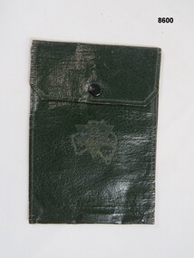 Bendigo Military Museum
Equipment - WALLET, Unknown
Green waterproof wallet, two inside pockets, brass press clip broken. A triangle shape over the map of Australia on front with inscription.On triangle & map of Australia, "Talk clean, live clean, fight clean, play the game."passchendaele barracks trust, wallet, waterproof, equipment -
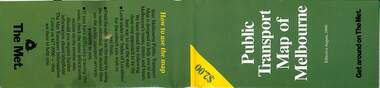 Melbourne Tram Museum
Map, The Met, Public Transport Map of Melbourne - Get around on The Met, 8/1990
Melbourne transport map - dated August 1990 - includes a map of the ticket zones, and The Met contact details and notes where tickets can be obtained fromYields information about Melbourne public transport services in August 1990Fold out map (36 sections 9 across x 4 deep), "Public Transport Map of Melbourne", coloured of Melbourne's Tram and Bus routes, route numbers, rail lines, detailed for the central part of Melbourne and the outer Metropolitan services.tramways, melbourne, tram services, bus services, railways, maps, zones -
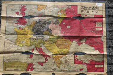 Lara RSL Sub Branch
Newspaper - The Sun Newspaper Dated 5/8/1944 -specia - World War 2 Europe Map and History Of World War 2 and Nazi Tide Flows and Ebbs Across Europe, THe Sun Newspaper Dated 5/8//1944 - Special War Maps
The Sun Newspaper Dated 5/8/1944 Local Newspaper Dated 5/8/1944 - Special World War 2 Maps World War 2 Europe Map and History Of World War 2 and Nazi Tide Flows and Ebbs Across Europeworld war 2 europe map and hisytory of world war 2 and nazi tide flows and ebbs across europe -
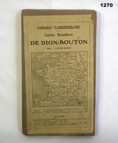 Bendigo Military Museum
Accessory - MAP, 1914-1919
The map belonged to Jack Grinton No 1043, 38th Batt AIF. Part of the Grinton collection which included hundreds of negatives and developed photos that he took during the War. Refer Cat No 1280 for service details. Refer 1317P, 1320P.Map of a small sector of France. The coloured map is on a grey canvas backing. Map covers an area from the coast to Amiens to St Quentin-north to south from Bethune-Arras-Richecourt. The map has 32 panels and folds down into one."Carte Routiere De Dion Bouton Amiens"docuents-maps-france, military history -
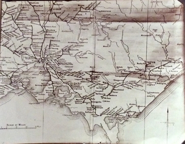 Phillip Island and District Historical Society Inc.
Photograph, Rail Lines of Victoria, Early to mid 20th century
Map showing extensive railway network in Victoria in early C20th.Sepia photo of map of Victoria showing rivers and railway lines and stations.Names of towns, rivers, bays etcsepia photograph, rail transport, victoria, map -
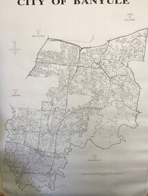 Greensborough Historical Society
Maps, Banyule City Council, City of Banyule, 1970c
Street map of City of Banyule. No physical features.Black and white map of City of Banyule. Scale: 8 cm:1 km. banyule city council -
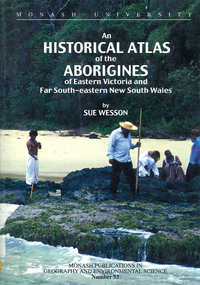 Victorian Aboriginal Corporation for Languages
Book, Sue Wesson, An historical atlas of the Aborigines of Eastern Victoria and Far South-eastern New South Wales, 2000
An extremely detailed atlas of tribes, clans, and languages in eastern Victoria and south-eastern New South Wales. Includes maps, census information about the numbers and makeup of these clans in historical records, meanings and comparative spellings of all known named tribes and clans.maps, b&w photographs, colour photographs, tables -
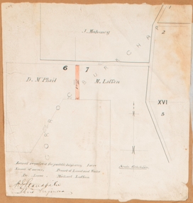 Bacchus Marsh & District Historical Society
Map, Land required for a public highway near Rowsley, Victoria. Circa 1880s
This map indicates portions of land in the Parish of Gorrockburkchap near Rowsley which was required for construction of a road. The land required was leased to a Michael Laffan. Other blocks of land nearby owned or leased by D. McPhail and J. Mahoney are also indicated on the map. The date of the map is not known. However newspaper reports in the Bacchus Marsh Express on the 18 March 1882, page 3, column 3 mention land occupied by McPhail and Laffan near Rowsley in connection to the construction of a public road.Single page map showing land occupied by farmers D. McPhail and Michael Laffan which was required for a public highway. Scale 6 chains to inch. Part of a set of maps which are pasted into a bound volume containing 76 maps or plans in total. High resolution digital image stored on BMDHS computer network. Signed by Shire Engineer, W.E. Standfieldrowsley victoria maps -
 Ballan Shire Historical Society
Map - Map. Moorarbool East and West, Country Lands in the Parishes of Moorarbool East and Moorarbool West. Counties of Bourke and Grant
This is a map of "Country Lands" around the Werribee River, north of Ballan in the Counties of Bourke and Grant.A relatively small map, paper on a material backing. Shows topographical features, roads and property divisions. Scale of forty chains to one inch. The map is dated March 31st, 1859.There is a small inscription under the chain scale that reads "No 58/364 John Phillips ? Survey 1st August 1858". The name Dugald McPherson is hand written on one of the blocks of land.moorarbool west, moorarbool east, dugald mcpherson, county of bourke, county of grant, werribee river, ballan -
 Ballan Shire Historical Society
Map - Map. Korweinguboora, Department of Lands and Survey, Korweinguboora. Counties of Talbot and Grant
A map of the Korweinguboora area showing roads, forests, railway lines and properties with the owners names.The inclusion of the names of landowners is of significance and value to historians.A map of the Korweinguboora area showing land subdivisions and names of owners and other physical features. There is a scale in chains. No date is certain but it could be 1902. The map has been repaired with sellotape.There are various pencil annotations but the are difficult to read.talbot, moorarbool west, wombat, bullarto, korweinguboora, moorarbool east, dean, wombat state forest, barkstead -
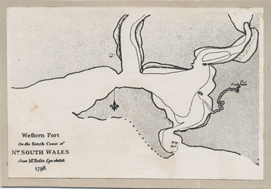 Phillip Island and District Historical Society Inc.
Photograph, Bryant West, 1798
One of a collection of over 400 photographs in an album commenced in 1960 and presented to the Phillip Island & Westernport Historical Society by the Shire of Phillip IslandPhotograph of the First Map of Phillip Island ever drawn. An eye sketch by Bass.As written on front of map - "Western Port on the South Coast of Nw. South Wales from GE Bass's Eye-sketch 1798"local history, photography, photographs, exploration, maritime, documents, maps, george bass, phillip island, bryant west, john jenner -
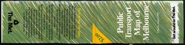 Melbourne Tram Museum
Map, The Met, Public Transport Map of Melbourne - Get around on The Met, 8/1989
Melbourne transport map - dated August 1989 - zone ticket system, has a photo of the front of B2 2004, includes a map of the ticket zones, and The Met contact details.Yields information about Melbourne public transport services in August 1989.Fold out map (36 sections 9 across x 4 deep), "Public Transport Map of Melbourne", coloured of Melbourne's Tram and Bus routes, route numbers, rail lines, detailed for the central part of Melbourne and the outer Metropolitan services.tramways, melbourne, tram services, bus services, railways, maps, zones -
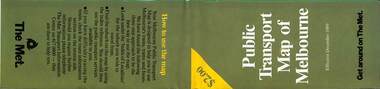 Melbourne Tram Museum
Map, The Met, Public Transport Map of Melbourne - Get around on The Met, 12/1989
Melbourne transport map - dated December 1989 - scratch ticket system, has a photo of the front of B2 2004, includes a map of the ticket zones, and The Met contact details.Yields information about Melbourne public transport services in December 1989 following the introduction of Scratch tickets.Fold out map (36 sections 9 across x 4 deep), "Public Transport Map of Melbourne", coloured of Melbourne's Tram and Bus routes, route numbers, rail lines, detailed for the central part of Melbourne and the outer Metropolitan services.tramways, melbourne, tram services, bus services, railways, maps, zones, scratch tickets -
 Greensborough Historical Society
Pamphlet - Directory, Greensborough Plaza directories, 2000s
Various shopping directories for Greensborough Plaza: 2001, 2007, and 2 undated pamphlets. Includes centre map.4 advertising pamphlets. Folded with colour illustrations and map.greensborough plaza, advertising images -
Stawell Historical Society Inc
Map, Stawell Gold Mines, Stawell Township 1995, 1995
Map shows details of mining activity Stockpiles, Tracks, Plant, Dams,, Waste, Tailing Dams, IronbarksPlain Printed Map in Black & White with details of MiningStawell Gold Mines Pty Ltdmining -
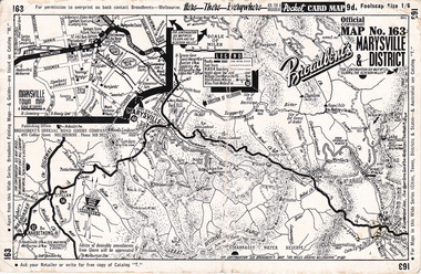 Marysville & District Historical Society
Ephemera (Item) - Pocket card map, Broadbent's Official Road Guides Company, Broadbent's Map No. 163 Marysville & District, 1950s
A pocket card map of Marysville and the district. Drawn map of Marysville and the district. Has a legend, scale and a town map of Marysville. Gives an address for Broadbent's Publishing Office of 475 Collins St Melbourne and a Melbourne telephone number - MR 2021. Reverse has advertisements for Barton's Store and Marylands Guest House in Marysville.A pocket card map of Marysville and the district. Gives information about Marysville and the district. Broadbent's was a prolific publisher of maps. marysville, victoria, maps, broadbent's, barton's store, marylands guest house -
Clunes Museum
Map
Map recovered from Estate sale at 31 Service Street, Clunes (former Fraser family residence and originally Shrigley residence)This item was donated by Catherine Jenkins/James Curzon from the Estate sale of Mr. Albert FraserMap of Clunes township printed on buff paperPrinted on front: In black ink, "Shire of Talbot and Clunes, Shire Eng. (name Illegible Boyd?) -/10/74map, clunes township, mr albert fraser, 31 service street -
 Melbourne Tram Museum
Map, Ministry of Transport, Melbourne Public Transport Map - No. 11, 1980
Map No. 11 dated on rear as 1980 - Includes description of tram and bus routes, private bus routes. Has contact details for bookings and lost property etc and how to use the map. Yields information about Melbourne public transport services in 1980Fold out map (27 sections 9 across x 3 deep), "Public Transport Map", coloured of Melbourne's Tram and Bus routes, route numbers, rail lines, detailed for the central part of Melbourne and the outer Metropolitan services.tramways, melbourne, tram services, bus services, railways, maps -
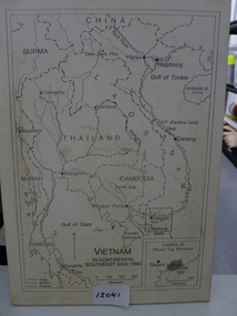 National Vietnam Veterans Museum (NVVM)
Map, Vietnam in Continental Southeast Asia 1965, 1965
Mounted black and white map of Southeast Asia with country borders and major cities marked. There is a highlight of Phuc Tuy Province in the lower righthand cornerCountries, cities and gulfs anotated map title - Vietnam in Continental Southeast Asia 1965map, phuc tuy -
 Kew Historical Society Inc
Map, Elizabeth Mackie, Kew 1875-1880s, c. 1985
Elizabeth Mackie was a member of the Kew Historical Society and a resident of 1 Molesworth Street. She researched and wrote the booklet 'Artists of Kew' and initiated research into authors with a connection to Kew. One of the most important maps of Kew in the KHS Collection is 'Back to Kew' created by Jesse Dannock. This water damaged map was in many places unreadable, and this re-creation by Elizabeth Mackie only included part of the original text. It was also liberally added to with pictorial symbols.A reinterpretation of the Back to Kew 1875 map created by Jesse Dannock in circa 1931. This hand-drawn map was created by Elizabeth Mackie in the 1980s.elizabeth mackie, plan of kew, maps -- kew (vic.), jesse dannock -
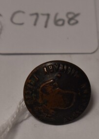
 Tatura Irrigation & Wartime Camps Museum
Button, P J King Pty Ltd
Issued to Sister Kathleen Heaphy of Australian Army Nursing service. Sister Heaphy was attached, for part of her service, to 28 Camp Hospital Internment camp 1.1 round brass button with a metal shank crown and map of Australia and wording around the circumference. A split pin is through the shank.Australian Military Forces and a crown and map of Australia. P. J. King Pty Ltd Melbourneaustralian army nursing service, sister kathleen heaphy, 28 camp hospital internment camp 1, brass buttons -
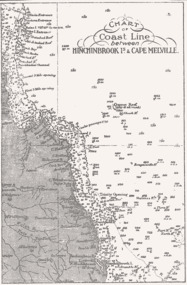 Queenscliffe Maritime Museum
Map - B & W coastal map of Hinchinbrook Island to Cape Melville in Queensland, Coastal map Queensland Hinchinbrook Is to Cape Melville, Before donation in 1987
Australian coastal mapsAustralian coastal mapsMap from unknown book of Queensland coast Hinchinbrook Island to Cape Melville, pre 1987Reverse " NIL "old maps of australian coast -
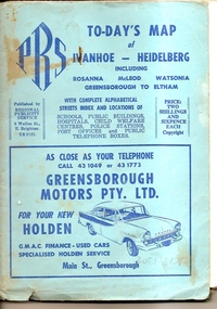 Greensborough Historical Society
Map, To-day's Map of Ivanhoe - Heidelberg; including Rosanna, McLeod, Watsonia, Greensborough to Eltham, 1937-1953
Map of the suburbs of Ivanhoe, Heidelberg, Rosanna, Macleod, Watsonia, Greensborough and Eltham. Dates to mid 1950s. An Advertiser on this map may be found in the Hurstbridge Advertiser Friday 17 December 1937, page 7: "Lyon Bros, of Eltham garage, suggest in their advertisement on the front page of this issue. that motorists should have their cars checked over by them before Christmas, so that any 5mall defects which might militate against the pleasure of the trip, might be remedied." As does "The Montsalvat Plant Farm" in The Age of Saturday 5 September 1953, page 48.Shows early streets and open space in these areas.Fold out map in pale blue cover. Cover dimensions: 21.5x15cm. Map is surrounded by advertising for local businesses.ivanhoe, maps, heidelberg, rosanna, macleod, watsonia, greensborough, eltham -
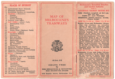 Melbourne Tram Museum
Map, Melbourne & Metropolitan Tramways Board (MMTB), "Map of Melbourne Tramways", 1934
Map booklet consists of three pages of bus and tram round trips, 3 center pages for a map of electric and cable trams, route numbers, and points of interest. Has 4 pages giving an index to routes and first and last trams to and from the City. Shows points where suburban routes are intersected by City routes. One page of places of interest. Dated 1934/35.Demonstrates methods of giving information to visitors to Melbourne and yields information about tram services at the time in Melbourne.Map - 2 octavo cards stapled and folded into 12 pages. All printing is in black with red headings and highlights except for the map which is in four colours.tramways, trams, mmtb, map, timetables, tourist trips -
 Ringwood and District Historical Society
Map, Commonwealth Department of Defence, Military Survey map of Ringwood, 1916, Jun-16
Map prepared by Commonwealth Section Imperial General Staff given to Ringwood Historical SocietyMilitary Survey map of Ringwood +Additional Keywords: Hutchins,LL.Hutchins, 16 King's Rd. Marysville 3779. Received by postpak -
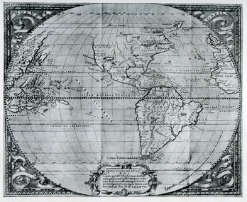 Ballarat Heritage Services
Map, Map Published at Paris, 1587, 1527
This map shows a portion of New Guinea, but the plae occupied by Austrlai was left as open ocean.Copy of a map from 'A Short HIstory of Australia' by Ernest Scott.map, paris map, new guinea, early australian mapping