Showing 4072 items
matching road plans
-
 Eltham District Historical Society Inc
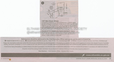
Document - Property Binder, 1307 Main Road, Eltham
Newspaper notice: Diamond Valley Leader, 31 January 2018, Calls for submissions re removal of reserve status and rezoning, Reserve 1 on Plan of Subdivision 213452R, Certificate of Title Volume 9879 Folio 829 and Reserve 2 on Plan of Subdivision 134133 Certificate of Title Volume 09434 Folio 620.main road, eltham, property -
 Eltham District Historical Society Inc
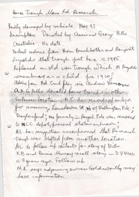
Document - Property Binder, 1524 Main Road, Research
Handwritten notes, undated, on A & G Bills horse trough Main Road Research. Handwritten notes, undated, "Annie and George Bills" listing locations of other Bills horse troughs. Typed notes by Dianna Basset-Smith, July 2003, her memories of the Bills trough at Research. Letter, RSPCE to Andrew Lemon, 17 December 1993, lists other horse troughs known to the RSPCA, use of money from Bills estate managed by John Crook. Newspaper article: Legacy is set in concrete, The Weekly Times, 25 June 2003, history of Bills horse troughs from 1930s, biography of George Bills and Annis Swarm [correctly Swann], quoting Barbie Roach, Gorge Bills' great-grandneice, notes locations of other Bills troughs. Newspaper article: No drought in water troughs, Weekly Times, 9 July 2003, Response to 25 June 2003 article, readers reporting Bills troughs in their area, photograph of trough at Korong Vale. Newspaper article: The horse lover, (photocopy, no publication details), Decaying Bills horse tough in Geelong council yard proposed to be moved to RSPCA, history of George Bills, Annis Bills (nee Swann), legacy, great-grandneice Judith Crook writing Bills history. Email exchange, Eltham District Historical Society and Geraldine Sanderson 2015: enquiry re Bills trough at Research for planned history of Bills trough, and provision of EDHS-held information.Annis Elizabeth Swannmain road, research (vic.), horse troughs, annis and george bills, bills trough, audrey bills, annis bills, george bills, barbie roach, royal society for the prevention of cruelty to animals, judith crook, audrey morton, kathleen wood, acclimatisation society, john lugg, ian stacey, harry bills, annis swann, james boreas crook, william buesst, myer emporium, richard bills, buesst and bills brothers, daisy bills -
 Eltham District Historical Society Inc
Postcard - Photograph postcard, Old Bridge, Kaylock's Crossing, Brougham Street, Eltham, c.1912
Date estimated to be circa 1912 based on the style of printing on the reverse of the card - Kodak Austral paper for real photo postcards, the paper was manufactured c.1908-1914 (See also POSTCARDS ON KODAK PAPER - IS IT POSSIBLE TO "DATE" THEM? http://tps.org.au/bb/viewtopic.php?t=115) Brougham Street was created in Josiah Holloway's 1851 subdivision of Little Eltham. It was one of several east-west streets shown on the subdivision plan as crossing the Diamond Creek. The western part was named Wellington Street on the subdivision plan but was later changed to conform with the name of the eastern part as acknowledgement of the continuity of the street. It is not known when the first bridge was constructed in Brougham Street however it was certainly mentioned at Council’s meeting of 2 June 1884 as being in a dangerous state of repair. This photo (c.1895) of an old bridge shows a very low-level simple log girder bridge crossing the creek at a right angle and so the approaches involved bends in the road alignment. This bridge was generally known as Kaylocks Bridge or Kaylock’s Crossing after the owner of the adjoining land. It was most likely built from around the mid-1850s, or a crossing of some fashion established as Richard George Kaylock, butcher of Little Eltham and his wife Emily Ann settled there in 1854. His property was in Wellington Street (now Brougham Street) and apparently extended across the Diamond Creek. The land on the western side of the creek was farmed, the house being on the eastern side. Kaylock's Bridge formed part of the original coach road to Eltham and in 1922 was described as an "old rustic bridge". Its low level and insubstantial construction made it susceptible to flood damage, necessitating frequent closures until repairs could be carried out. In September 1922, Council called for tenders for a new timber bridge to be constructed at Kaylock’s crossing. An engineering assessment carried out for the Council by Macleod Consulting at the time of the replacement suggested that the construction details indicate that it was in the 1900s, however this dating could possibly have been the result of numerous repairs undertaken over the years to flood damage. The tender was awarded to Mr Weller of Kangaroo Ground who commenced work in February 1923 on a higher-level timber trestle bridge. Work was slowed due to illness of the contractor and the accidental death of a man in March 1923 following the collapse of the bank after he had jumped into a hole that had just been blasted. The bridge was completed around July 1923 at which point the old structure was pulled up, marking what was described in the ‘Advertiser’ newspaper as the passing of an old and well-loved landmark in the district. In April 1924 the approach to Kaylocks bridge was washed away during the heavy flooding that destroyed the Main Road bridge. The western side was repaired, and an extra span was added to the eastern side using timber from the destroyed Main Road bridge. The bridge was again severely damaged four months later in August 1924 When a lack of finances delayed repairs to the Bridge Street bridge in 1931 (also referred to as Obelisk Bridge at the time), traffic had to detour via Brougham Street for some time. Local residents feared that the Bridge Street bridge might never reopen. Kaylocks Bridge was constantly subject to damage by floods. In the 1934 flood it was submerged by two feet of water. In more recent times the bridge was again severely damaged by flooding and repairs made. A new bridge and adjoining footbridge were constructed in 2009.Digital file only Postcards scanned from the collection of Michael Aitken on loan to EDHS, 2 Sep. 2022michael aitken collection, eltham, postcards, bridge, brougham street, diamond creek (creek), kaylocks bridge, wellington street -
 Eltham District Historical Society Inc
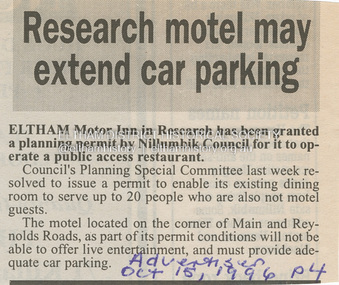
Document - Property Binder, 1450 Main Road, Eltham
Newspaper article: Research motel may extend car parking, Advertiser, 15 October 1996, Eltham Motor Inn granted planning permit by Nillumbik Council to operate a public access restaurant, must provide parking.main road, eltham, businesses, eltham motor inn, nillumbik council -
 Eltham District Historical Society Inc
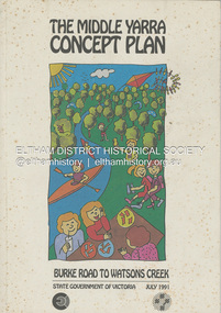
Book, State Government of Victoria, The Middle Yarra Concept Plan: Burke Road to Watsons Creek, July 1991
... The Middle Yarra Concept Plan: Burke Road to Watsons Creek... between Burke Road and Watsons Creek which includes planning ...A draft concept plan developed for the Middle Yarra River between Burke Road and Watsons Creek which includes planning controls, developed and managed to meet the recreation and landscape objectives whilst protecting the natural resourcesa nd cultural heritage. It established a broad framework for more detailed plans and guidelines. Jointly produced by staff from the Victorian Department of Planning and Housing. July 1991.non-fictionA draft concept plan developed for the Middle Yarra River between Burke Road and Watsons Creek which includes planning controls, developed and managed to meet the recreation and landscape objectives whilst protecting the natural resourcesa nd cultural heritage. It established a broad framework for more detailed plans and guidelines. Jointly produced by staff from the Victorian Department of Planning and Housing. July 1991.recreation areas, regional planning, yarra river, watsons creek -
 Eltham District Historical Society Inc
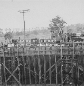
Album - Photograph, J.A. McDonald, Dixons Creek Road, June 1957
Bridge over Dixons Creek Job 56FD330 June 1957 Formwork for Dixons Creek pier completed Advertising (1957, January 19). The Argus (Melbourne, Vic. : 1848 - 1957), p. 33 (Col. 9). Retrieved August 24, 2022, from http://nla.gov.au/nla.news-article71777065 SHIRE OF ELTHAM. Loan No. 27.-Notice of Intention to Borrow Sum of £ 15,000 for Permanent Works and Undertakings. - Notice is hereby given, that the Council of the Shire of Eltham proposes to borrow the sum of £15,000 on the credit of the municipal revenues of the president, councillors, and ratepayers for the said shire, such sum to be raised by the Issue of debentures in accordance with the provisions of the Local Government Acts. 1. Maximum rate of interest that may be paid is £5/10/ per cent, per annum. 2. The purposes for which the loan is to be applied are: Construction of Sanitary Conveniences at Shire Office, Council's contribution towards costs of Dixons Creek Bridge, Construction of Mt. Pleasant rd., Construction of Cherry Tree rd. 3. The period of the loan shall be 10 years. 4. Moneys borrowed will be repayable by providing out of the Municipal Fund twenty half-yearly instalments of approximately £985/1/6 each, including principal and interest on the first day of October and the first day of April during the currency of the loan. The first Instalment shall be payable on the first day of October 1957. 5. Such moneys shall be repayable at the Commercial Bank of Australia Limited, Melbourne, or at the Council's bankers for the time being in Melbourne. The plans and specifications and the estimates of the costs of the proposed works and a statement showing the proposed expenditure of the moneys to be borrowed are open for inspection at the Shire Office, Eltham. R. J. HAM. Shire Secretary.Record of various Shire of Eltham infrastructure works undertaken during the period of 1952-1962 involving bridge and road reconstruction projects, sometimes with Eltham Shire Council Project Reference numbers quoted. It was during this period that a number of significant improvements were made to roads and new bridges constructed within the shire that remain in place as of present day (2022). In many situations, the photos provide a tangible visible record of infrastructure that existed throughout the early days of the Shire. The album was put together by or under the direction of the Shire Engineer, J.A. McDonald.infrastructure, road construction, shire of eltham, bridge construction, dixons creek bridge, dixon's creek road, 1957-06 -
 Eltham District Historical Society Inc
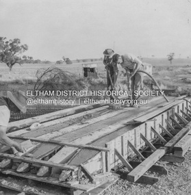
Album - Photograph, J.A. McDonald, Dixons Creek Road, June 1957
Piles being cast 1957 P. Morris on vibrator Advertising (1957, January 19). The Argus (Melbourne, Vic. : 1848 - 1957), p. 33 (Col. 9). Retrieved August 24, 2022, from http://nla.gov.au/nla.news-article71777065 SHIRE OF ELTHAM. Loan No. 27.-Notice of Intention to Borrow Sum of £ 15,000 for Permanent Works and Undertakings. - Notice is hereby given, that the Council of the Shire of Eltham proposes to borrow the sum of £15,000 on the credit of the municipal revenues of the president, councillors, and ratepayers for the said shire, such sum to be raised by the Issue of debentures in accordance with the provisions of the Local Government Acts. 1. Maximum rate of interest that may be paid is £5/10/ per cent, per annum. 2. The purposes for which the loan is to be applied are: Construction of Sanitary Conveniences at Shire Office, Council's contribution towards costs of Dixons Creek Bridge, Construction of Mt. Pleasant rd., Construction of Cherry Tree rd. 3. The period of the loan shall be 10 years. 4. Moneys borrowed will be repayable by providing out of the Municipal Fund twenty half-yearly instalments of approximately £985/1/6 each, including principal and interest on the first day of October and the first day of April during the currency of the loan. The first Instalment shall be payable on the first day of October 1957. 5. Such moneys shall be repayable at the Commercial Bank of Australia Limited, Melbourne, or at the Council's bankers for the time being in Melbourne. The plans and specifications and the estimates of the costs of the proposed works and a statement showing the proposed expenditure of the moneys to be borrowed are open for inspection at the Shire Office, Eltham. R. J. HAM. Shire Secretary.Record of various Shire of Eltham infrastructure works undertaken during the period of 1952-1962 involving bridge and road reconstruction projects, sometimes with Eltham Shire Council Project Reference numbers quoted. It was during this period that a number of significant improvements were made to roads and new bridges constructed within the shire that remain in place as of present day (2022). In many situations, the photos provide a tangible visible record of infrastructure that existed throughout the early days of the Shire. The album was put together by or under the direction of the Shire Engineer, J.A. McDonald.infrastructure, road construction, shire of eltham, bridge construction, dixons creek bridge, dixon's creek road, 1957-06, p. morris -
 Eltham District Historical Society Inc
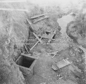
Album - Photograph, J.A. McDonald, Dixons Creek Road, June 1957
Dixons Creek Road P. Morris – Contractor Dixons Creek (North) abutment 1957 Advertising (1957, January 19). The Argus (Melbourne, Vic. : 1848 - 1957), p. 33 (Col. 9). Retrieved August 24, 2022, from http://nla.gov.au/nla.news-article71777065 SHIRE OF ELTHAM. Loan No. 27.-Notice of Intention to Borrow Sum of £ 15,000 for Permanent Works and Undertakings. - Notice is hereby given, that the Council of the Shire of Eltham proposes to borrow the sum of £15,000 on the credit of the municipal revenues of the president, councillors, and ratepayers for the said shire, such sum to be raised by the Issue of debentures in accordance with the provisions of the Local Government Acts. 1. Maximum rate of interest that may be paid is £5/10/ per cent, per annum. 2. The purposes for which the loan is to be applied are: Construction of Sanitary Conveniences at Shire Office, Council's contribution towards costs of Dixons Creek Bridge, Construction of Mt. Pleasant rd., Construction of Cherry Tree rd. 3. The period of the loan shall be 10 years. 4. Moneys borrowed will be repayable by providing out of the Municipal Fund twenty half-yearly instalments of approximately £985/1/6 each, including principal and interest on the first day of October and the first day of April during the currency of the loan. The first Instalment shall be payable on the first day of October 1957. 5. Such moneys shall be repayable at the Commercial Bank of Australia Limited, Melbourne, or at the Council's bankers for the time being in Melbourne. The plans and specifications and the estimates of the costs of the proposed works and a statement showing the proposed expenditure of the moneys to be borrowed are open for inspection at the Shire Office, Eltham. R. J. HAM. Shire Secretary.Record of various Shire of Eltham infrastructure works undertaken during the period of 1952-1962 involving bridge and road reconstruction projects, sometimes with Eltham Shire Council Project Reference numbers quoted. It was during this period that a number of significant improvements were made to roads and new bridges constructed within the shire that remain in place as of present day (2022). In many situations, the photos provide a tangible visible record of infrastructure that existed throughout the early days of the Shire. The album was put together by or under the direction of the Shire Engineer, J.A. McDonald.infrastructure, road construction, shire of eltham, bridge construction, dixons creek bridge, dixon's creek road, 1957-06 -
 Eltham District Historical Society Inc
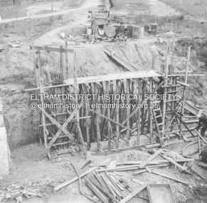
Album - Photograph, J.A. McDonald, Dixons Creek Road, June 1957
Dixons Creek Road Bridge over Dixons Creek – 56FD330 June 1957 Dixons Creek pier forming columns and beam Advertising (1957, January 19). The Argus (Melbourne, Vic. : 1848 - 1957), p. 33 (Col. 9). Retrieved August 24, 2022, from http://nla.gov.au/nla.news-article71777065 SHIRE OF ELTHAM. Loan No. 27.-Notice of Intention to Borrow Sum of £ 15,000 for Permanent Works and Undertakings. - Notice is hereby given, that the Council of the Shire of Eltham proposes to borrow the sum of £15,000 on the credit of the municipal revenues of the president, councillors, and ratepayers for the said shire, such sum to be raised by the Issue of debentures in accordance with the provisions of the Local Government Acts. 1. Maximum rate of interest that may be paid is £5/10/ per cent, per annum. 2. The purposes for which the loan is to be applied are: Construction of Sanitary Conveniences at Shire Office, Council's contribution towards costs of Dixons Creek Bridge, Construction of Mt. Pleasant rd., Construction of Cherry Tree rd. 3. The period of the loan shall be 10 years. 4. Moneys borrowed will be repayable by providing out of the Municipal Fund twenty half-yearly instalments of approximately £985/1/6 each, including principal and interest on the first day of October and the first day of April during the currency of the loan. The first Instalment shall be payable on the first day of October 1957. 5. Such moneys shall be repayable at the Commercial Bank of Australia Limited, Melbourne, or at the Council's bankers for the time being in Melbourne. The plans and specifications and the estimates of the costs of the proposed works and a statement showing the proposed expenditure of the moneys to be borrowed are open for inspection at the Shire Office, Eltham. R. J. HAM. Shire Secretary.Record of various Shire of Eltham infrastructure works undertaken during the period of 1952-1962 involving bridge and road reconstruction projects, sometimes with Eltham Shire Council Project Reference numbers quoted. It was during this period that a number of significant improvements were made to roads and new bridges constructed within the shire that remain in place as of present day (2022). In many situations, the photos provide a tangible visible record of infrastructure that existed throughout the early days of the Shire. The album was put together by or under the direction of the Shire Engineer, J.A. McDonald.infrastructure, road construction, shire of eltham, bridge construction, dixons creek bridge, dixon's creek road, 1957-06 -
 Eltham District Historical Society Inc
Album - Photograph, J.A. McDonald, Garden Hill, Kangaroo Ground, Feb. 1963
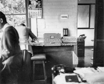
Most likley the interior of the Eltham Shire Offices at the corner of Artur Street and Main Road. The calendar is set on February 1963. ERngineering and Planning were also loacted in the shop fronts located next door on Main Road.Record of various Shire of Eltham infrastructure works undertaken during the period of 1952-1962 involving bridge and road reconstruction projects, sometimes with Eltham Shire Council Project Reference numbers quoted. It was during this period that a number of significant improvements were made to roads and new bridges constructed within the shire that remain in place as of present day (2022). In many situations, the photos provide a tangible visible record of infrastructure that existed throughout the early days of the Shire. The album was put together by or under the direction of the Shire Engineer, J.A. McDonald.arthur street, eltham, eltham shire office, main road, 1963-02 -
 Eltham District Historical Society Inc
Document - Property Binder, 559 Main Road, Eltham
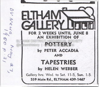
Newspaper advertisement: Diamond Valley News, 27 May 1980, Exhibition, Peter Accadia, pottery, and Helen Webber, tapestries. Newspaper article: Five for the price of one, Diamond Valley News, Tuesday, July 8, 1986, p27; exhibition of five artists at Eltham Gallery. On reverse, numerous advertisements for food and entertainment Newspaper advertisement: The Age ,17 June 1989, Exhibition, Donald Ramsay "Watching the river flow". Newspaper article: Landmark gallery says goodbye, Diamond Valley Leader, 24 November 2004, Gallery site sold to Sentinel Equities, present tenant Julie Skate, quotes from former part-owner Val Murray. Newspaper article: Rift over gallery plans, Diamond Valley Leader, 21 February 2007, purchasers Jethro Tull and Suzanne Still plan to build offices, gallery and cafe; Eltham Gateway Action Group objected while supporting need for a gallery elsewhere. Newspaper article: New try for gallery-cafe ready soon, Diamond Valley Leader, 18 April 2007, purchaser Jethro Tull to have a new plan ready in two weeks for gallery and cafe. Newspaper article: Gateway for artists, Diamond Valley Leader, 25 May 2007, Jenni Mitchell opened a new gallery pending decision by Nillumbik Council. Newspaper article: Art gallery proposal rejected, Diamond Valley Leader, 30 May 2007, Nillumbik Council against planned new building. Newspaper article: Artful win for gallery, Diamond Valley Leader, 30 January 2008, VCAT approved mudbrick art gallery. Newspaper article: Rocky road to create a landmark, Diamond Valley Leader, 13 February 2008, VCAT approved Robert Marshall's design, artists's impression, Eltham Gateway Action Group opposed.main road, property, businesses, eltham gallery, wiregrass gallery, eltham gateway action group, robert marshall, mud brick building, eltham (vic), 559 main road eltham, artists, bernhard rust, bob smith, jan neil, john adams, marian sussex, michael wilson, tony dopheide, 47-55 main street diamond creek, 50 were street montmorency, 55 rattray road montmorency, 410 main road lower plenty, abbey of diamond creek, adams north riding restaurant, advertising, eltham barrel, montmorency, mustard seed restaurant, peking house restaurant, st andrews, tamara's -
 Eltham District Historical Society Inc
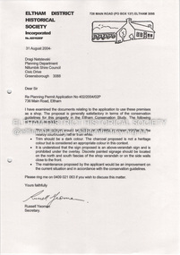
Document - Property Binder, 672 Main Road, Eltham
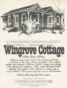
... , invitation to review re planning application. Main Road Eltham ...Flyer, Neville Emerson Pty Ltd, for sale Wingrove Cottage. Shire of Eltham Heritage Study, nd but post 1989: Wingrove Cottage. Note: June 1997 re Judy David, descendant of Mr Wingrove. Note: 2 September 2003: Greg Johnson description of building. Statement 2 September 2003 from Francis Percival (Jock) Read of memories of Wingrove Cottage. Copy letter 21 October 2002 from Value Creating Environments (recent purchasers of Wingrove site) to John Karageorge Planning and Building Services Nillumbik Shire re planned work; also attachment re possible site development. Newspaper article: Diamond Valley Leader, 23 October 2002, Angry crowd stops demolition, photograph of part demolition. Letter 30 December 2002 from Stephen Coleriro Acting Manager Planning and Building Services Nillumbik Shire re consultation on illegal demolition works at Wingrove Cottage. Letter 24 February 2003 from Allom Lovell & Associates to John Karageorge Shire of Nillumbik commenting on Wingrove Cottage work. Newspaper article: Diamond Valley Leader, 17 September 2003, Court orders restoration at cottage. Newspaper article: Diamond Valley Leader, 25 February 2004, Health vision for Eltham's 1800s home, Wingrove Cottage will be restored as health and wellness centre if plans approved. Newspaper article: Diamond Valley Leader, 7 July 2004, 1850s bricks in debris, Jim Cummane owner ordered to prepare conservation plan, photograph of site and Harry Gilham president Eltham District Historical Society. Newspaper article: Diamond Valley Leader, 1 December 2004, Cottage heritage plan crucial to sale success, site to be sold, photograph of Wingrove Cottage. Letter 14 April 2005 from Gaye Van Donkelaar Planning and Building Services Nillumbik Shire to Russell Yeoman Eltham District Historical Society re meeting of key stakeholders 27 April 2005. Newspaper article: Diamond Valley Leader, 28 March 2007, Cottage work on hold, recent purchasers Cameron Construction restored Cottage, open as photographic studio, applied for permit to build office and 7 homes on site. Letter 13 August 2007 from Senior Registrar VCAt to Eltham District Historical Society enclosing VCAT order re application for 672 Main Road. Letter 24 August 2007 from Colin Bowden Planning and Development Consultants to VCAT enclosing response prepared by O'Brien Traffic for VCAT. Letter 14 February 2007 from Jeremy Livingstone Planning and Building Services Nillumbik Shire, invitation to review re planning application.main road, eltham, property, houses, wingrove cottage -
 Eltham District Historical Society Inc
Document - Property Binder, 725 Main Road, Eltham
Photocopy (A4): Map hand drawn by Peter Grier, brother to Wendy Wilson, commissioned by jeweler, Michael Wilson showing his business 'Eltham Goldsmithery' c.1979-1981. Newspaper article: Art and design venue, Diamond Valley News, August 14, 1996, p14 where it is announced that the business has been approved as an outlet for Italian design house Alessi. In same article a reference to an exhibition by the deceased 'Twenty Melbourne Painters' hanging at the Victorian Artists Society Gallery and former and present day connections with Eltham area including Angela Abbott, Peter Glass, Alan Martin, Lesley Martin, Max Meldrum, Percy Leason, Alice Bale, Walter Withers, Margery Withers, Richard Mccann. (On p13 letters to the Editor about protesting against inappropriate development and the Commissioners plans for future elected Nillumbik Council structural representation). Advertisement 19 June 2013, Michael Wilson diamond jewellers. Advertising flier 23 November 2020, Michael Wilson.main road, eltham, property, houses, shops, businesses, michael wilson jewellers, peter grier, map, eltham goldsmithery, artisans minting, cafe de chin, diamond valley railway, eltham barrel, eltham clinic, eltham collegeeltham hotel, eltham community centre, eltham gallery, eltham railway station, eltham shopping centre, eltham town park, gallery 4, john mills pottery, living and learning centre, montsalvatcountry arts store, once upon a time land, shillinglaw cottagewiregrass gallery, wingrove park, michael wilson diamond jewellers -
 Eltham District Historical Society Inc
Document - Property Binder, 736 Main Road, Eltham
Letter 31 August 2004 Eltham District Historical Society to Dragi Natstevski Planning Department Nillumbik Shire Council commenting on Planning Permit Application No 402/2004/02P, Part Shire of Eltham Heritage Study, pages 1440-1243, re brick shop and side dwelling 738 Main Road. Entry in Victorian Heritage Database for 738 Main Road Eltham. Newspaper article: Beacons of light, Marguerite Marshall; Copperline Inaugural Edition, October 2022 Newspaper article: Beacons of light update, Marguerite Marshall; Copperline Edition 7, July 2023main road, eltham, property, houses, shops, zen den cafe, 736 main road eltham -
 Eltham District Historical Society Inc
Document - Property Binder, 739 Main Road, Eltham
... plan. Main Road Eltham Property Houses Shops Businesses Claire ...Letter 1 December 1994 from Harry Gilham to Russell Yeoman Eltham Shire Offices, re history of property: sold by Matthews family to Claire Fitzpatrick and husband, then sold to Shire of Eltham for Living and Learning Centre, 9 November 1994 sketch plan.main road, eltham, property, houses, shops, businesses, claire fitzpatrick, eltham living and learning centre -
 Eltham District Historical Society Inc
Document - Property Binder, 801 Main Road, Eltham
... July 1987. 9. Plan of Main Road Eltham - it depicts buildings... July 1987. 9. Plan of Main Road Eltham - it depicts buildings ...1. Plan: Henry Dendy's Eltham Land 1857-1867: showing Diamond Creek, Bridge Street, Maria Street now Main Road, John Street, Pitt Street, St Margaret's Church 1861, and Eltham Community Centre 1987. 2. Photocopy extract from "Henry Dendy and his emigrants" by L A Schumer, re Portions 12 and 13, Parish of Nillumbik. 3. The President and Councillors of the Shire of Eltham request the pleasure of ____ at the Official Opening of the Eltham Community Centre, Cnr Main Road and Pitt Street, Eltham by the Honorable R.J. Hamer E.D., M.P., Premier of Victoria on Saturday, 22nd April, 1978 at 3.30pm 4. Souvenir Program, Opening of Eltham Community Centre 22 April 1975. 5. Invitation to attend Official Opening of Eltham Community Centre by R J Hamer, Premier of Victoria, 22 April 1975. 6. Flier for Eltham Reception and Conference Centre, photographs of interiors during events. 7. Newspaper article: Eltham buries present for the future, Diamond Valley News 19 November 1985 Eltham, photograph of burying time capsule outside Eltham Community Centre, photograph of Bill Baker and Sid Brown outside old blacksmith shop the original site of Eltham town centre. 8. Letter Peter Butler Shire of Eltham to Eltham District Historical Society, 6 July 1987, detailing process for naming of the halls at the Eltham Community Centre.6 July 1987. 9. Plan of Main Road Eltham - it depicts buildings and occupiers from Pitt Street to Luck Street in the first half of the 20th century. This plan was compiled as a joint efforts by members of the Shire of Eltham Historical Society at a general meeting in Eltham during the 1980s. Newspaper article: Swimming pool and community centre receive major revamps, Diamond Valley Leader, 21 October 2015.main road, eltham, eltham community centre, henry dendy, eltham reception and conference centre, bill baker, sidney brown blacksmith, tme capsule, arthur street, babe taylor house, bakery, boarding house, bradley house, bridge street, brown blacksmith, burgoyne's shop, cockcrofts store, commercial bank of australasia, david lyon house, davis, dr cordner, dr hall, dudley street, eltham hotel, eltham obelisk, eltham war memorial, garnet burges, graham, hawker, henry street, john lyon, len perron, luck street, lyons garage, map, mechanics insitute, monteith house, mrs morris shop, our lady help of christian’s primary school, panther place, pitt street, prior street, shillinglaw cottage, shops, stones mixed shop, websters house, wesleyan methodist church, york street -
 Eltham District Historical Society Inc
Document - Property Binder, 810 Main Road, Eltham
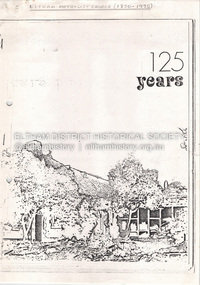
Photocopy publication: Eltham Methodist Church One Hundred and Twenty-Five Years 1850-1975, Chris Allan editor. History of early Eltham, railway, schools, churches by A Bird. Map of Eltham with sites of significant buildings. Maps church site. Plan of church. Reminiscences by Edna Bill, Val Gangell, Don Brown. Notes by Ken Eckersall, Peter Gray, Ron Hubery. Newspaper article: Lessons in history, Diamond Valley News, 2 August 2000. Newspaper article: Parents stop teachers, Diamond Valley News, 2 August 2000, State-wide preschool teachers strike and Hurstbridge pre-school.main road, eltham, eltham methodist church, eltham uniting church, josiah holloway, hurstbridge pre-school, kinglake national park, churches -
 Eltham District Historical Society Inc
Document - Property Binder, 813 Main Road, Eltham
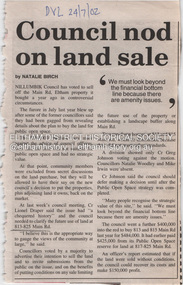
Newspaper article: Council nod on land sale, Diamond Valley Leader, 24 July 2002, Nillumbik Council voted to sell this land. Newspaper article: Grapple on Gateway, Diamond Valley Leader, 11 September 2002, photograph of demonstrators against development of land. Newspaper article: Prominent site protected, Diamond Valley Leader, 6 December 2006, Victorian Civil and Administrative Tribunal upheld decision to refuse development permit, action by Eltham Gateway Action Group. Newspaper article: Daniel's a tree fella, Diamond Valley Leader, 24 July 2002, Daniel Jarvis involved in Planet Ark's National Tree Planing Day, Friends of Falkiner Street Reserve.main road, eltham, property, eltham gateway action group, daniel jarvis, friends of falkiner street reserve. -
 Eltham District Historical Society Inc
Document - Property Binder, 820 Main Road, Eltham
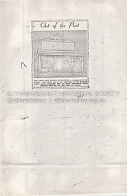
Photocopy newspaper clipping: Out of the Past, 1958, photograph of first post office at Eltham in 1880s, image owned by the Burgoyne family who had long association with the Postal Department. Photocopy Tabular Return of Post Offices in Victoria 1855-1856, including Kangaroo Ground (Andrew Ross), Little Eltham (Thomas Hunniford, Saint Andrew (William Watson). Typed newspaper article: District Roads Boards, The Argus 2 October 1867, re opening of post office savings banks and money order offices at (among others) Eltham. Index card: Thomas Hunniford, Anne Hunniford, Eltham Post Office, Eltham Telegraph Office. Letter Nillumbik Shire to Eltham District Historical Society, 9 December 2015, re Planning Application 377/2015/06P. Letter Nillumbik Shire to Eltham District Historical Society, 2 February 2016, conference re Planning Application 377/2015/06P.. Newspaper article: Beauty is in the eye of the beholder, Manningham and Nillumbik Bulletin, November 2021, re stonework on building.main road, eltham, property, businesses, eltham post office, burgoyne family, kangaroo ground post office, little eltham post office, saint andrew post office, andrew ross, thomas hunniford, william watson, anne hunniford, eltham telegraph office -
 Eltham District Historical Society Inc
Document - Property Binder, 825 Main Road, Eltham
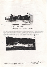
... 2008, Nillumbik Council approved development plans. Main Road ...Photocopy photographs Evelyn Hotel Eltham and Eltham Swimming Pool, images owned by Garreth Burges. Elevations west, north, south, east, of proposed development by Germano Architects. Floor plans of proposed development by Germano Architects. Newspaper article: Council to reject apartments plan, Diamond Valley News, 20 May 1998, Nillumbik Council meeting, protestors against 25 unit development from Eltham Gateway Action Group. Newspaper public notice: Diamond Valley Leader 1 March 2006, Notice of Application for a Planning Permit, by Germano Architects. Newspaper article: Building at long last, Diamond Valley Leader, 3 September 2008, Nillumbik Council approved development plans.main road, eltham, property, businesses, evelyn hotel eltham, eltham swimming pool, eltham gateway action group, germano architects -
 Eltham District Historical Society Inc
Document - Property Binder, 826 Main Road, Eltham
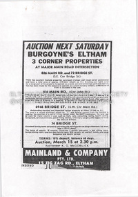
Photocopy advertisement, sale three corner properties at Main Road intersection, by Burgoyne family. Newspaper article: Nod for medical centre plan, Diamond Valley News, May 31, 1995 - Nillumbik Council approved plans for medical facility and chiuld minding centre at the corner of Bridge Road and Main Road however not all members of the Planning Special Committee were in support - eventually did not proceed and units were built with the address of 72 Bridge Roadmain road, eltham, property, burgoyne family, medical centre, 72 bridge street, 826 main road, bridge street, child minding centre, don cordell, jim connor, nillumbik planning special committee, tony lazzarotto -
 Eltham District Historical Society Inc
Document - Property Binder, 727 Main Road, Eltham
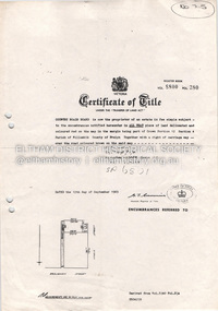
Copy Certificate of Title, plan of subdivision Part of Crown Portion 12 Section 4 Parish of Nillumbik County of Evelyn.main road, eltham, property, houses, shops, businesses -
 Eltham District Historical Society Inc
Document - Property Binder, 907 Main Road, Eltham
Newspaper article: $6000 grant to Our Lady's, The Advertiser, July 2, 1996 - Grant given to Parish of Our LadyHelp of Christians which is taking over the use of the Eltham War Memorial Hall in Main Road and the Nillumbik After School Program. (Other items include: St Andrews Submission Re application to subdivide 1726 Heidelberg-Kinglake Road; Minister's decision awaited - A six-eight lot subdivision at Eagles Nest Road, Strathewen; Mt Pleasant Rd petition - Need for a shared pathway; Policy on ad signs - Amended policy on advertising signs for community events; Main Rd streetscape plan - Plans for streetscape improvement in Main Road to go on display; Special meeting dates set - Special meetings to consider formal submissions and then adopt a final proposal for Shire's electoral structure for Ministerial approval and gazettal. Letter Eltham District Historical Society to Nillumbik Shire Council, 16 September 1996: Proposed roundabouts Main Road Eltham at Dudley Street and Panther Place. Newspaper article: Diamond Valley News 16 October 1996, Pre-school welcomes plan for traffic lights.main road, eltham, property, roundabouts, dudley street, panther place, eltham pre-school, eltham war memorial -
 Eltham District Historical Society Inc
Document - Folder, Survey Maps and Technical Drawings
alan gardiner collection, maps -
 Eltham District Historical Society Inc
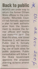
Newspaper - Newspaper Clipping, Diamond Valley Leader, Back to public, Diamond Valley Leader, 22 November, 2006
Nillumbik Shire Council plans to re-zone the former Eltham Shire Office site and Eltham War Memorial from Buisness 2 to Public Use 6895 main road, eltham, eltham shire office, eltham war memorial, nillumbik shire council, re-zoning -
 Eltham District Historical Society Inc
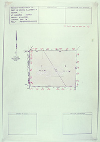
Slide - Photograph, Eltham Shire Council, Plan of Subdivision, Crown Allotment 8, Section 8A, Parish of Nillumbik,County of Evelyn, 1969
... of Nillumbik Plan of Subdivision planning Research-Warrandyte Road ...35mm colour positive transparency blue Agfacolour Service plastic mountC1, Pain, Sibbel and Carter, Research-Warrandyte Road, North Warrandyte, 4 August 1969carter, infrastructure, map, north warrandyte, pain, parish of nillumbik, plan of subdivision, planning, research-warrandyte road, sibbel, subdivison lots -
 Eltham District Historical Society Inc
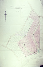
Slide - Photograph, Eltham Shire Council, Plan of Subdivision of Part of Crown Allotment 4, Section 2 at Kangaroo Ground, Parish of Nillumbik, County of Evelyn, 1969
35mm colour positive transparency blue Agfacolour Service plastic mountC6, Kimse, Kangaroo Ground-St Andrews Road, 4 August 1969infrastructure, kangaroo ground, kangaroo ground-st andrews rd, kimse, map, plan of subdivision, planning, subdivison lots -
 Eltham District Historical Society Inc
Slide - Photograph, Eltham Shire Council, Plan of Subdivision, Part of Crown Portion 3, Parish of Nillumbik, County of Bourke, 1969
... melbourne Infrastructure Map Montmorency planning Rattray Road ...35mm colour positive transparency blue Agfacolour Service plastic mountC5C, Delbridge, 4 lots, Rattray Road, 4 August 1969infrastructure, map, montmorency, planning, rattray road, subdivison lots, reichelt avenue -
 Eltham District Historical Society Inc
Slide - Photograph, Eltham Shire Council, Proposed plan of subdivision, Mrs Du Lee, Warrandyte, 1969
35mm colour positive transparency blue Agfacolour Service plastic mountB2, Du Lee Subdivision, Research-Warrandyte Road, 4 August 1969infrastructure, map, planning, subdivison lots, du lee, glynns road, research-warrandyte road -
 Eltham District Historical Society Inc
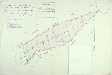
Slide - Photograph, Eltham Shire Council, Plan of subdivision of Part of Crown Allotment 41, Parish of Kinglake, County of Anglesey, 1969
35mm colour positive transparency blue Agfacolour Service plastic mountC8, N. Johnson, Kinglake-Glenburn Road, 4 August 1969infrastructure, map, planning, subdivison lots, n. johnson, kinglake-glenburn road, kinglake