Showing 1870 items matching "subdivision"
-
 Ringwood and District Historical Society
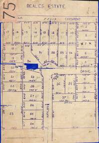
Map, Subdivision Plan of 37 residential allotments on Panorama Avenue, Felix Crescent, Evelyn Road and Avalon Grove, Ringwood, Victoria - (Undated - circa 1960)
Stencilled copy of map on blue cardboard backingBeales Estate -
 Ringwood and District Historical Society
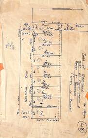
Map, Subdivision Plan - 8 residential allotments south of City Road on Wantirna Road, Ringwood, Victoria - (Undated - circa 1950s)
Hand-drawn map on cardboard backing.Part of Crown Portion 11, Parish of Ringwood, County of Bourke. Some allotments include real estate sales notations. (North arrow incorrectly points east.) -
 Ringwood and District Historical Society
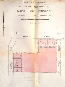
Document, Plan of Subdivision - Part of Crown Allotment 10A, Parish of Ringwood, County of Mornington - 1957
Map of residential allotments in Wantirna Road and Reilly Street, Ringwood, and Philip Street, Heathmont, Vic.Footnote includes "Lots numbered 5 to 11 and 16 to 23 both inclusive are not included in this plan. Signature of Consulting Engineer - Alan J. Brown BCE, LS, MVIS, Licensed Surveyor, Dillons Buildings, 1 Riversdale Road, Camberwell (Phone) WF3528 dated 1-4-1957. -
 Ringwood and District Historical Society
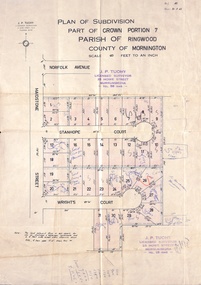
Document, Plan of Subdivision - Part of Crown Portion 7, Parish of Ringwood, County of Mornington - 1962
Map of residential allotments coloured red, with land coloured blue set apart for drainage & sewerage easements. Rubber stamped J.P. Tuohy, Licensed Surveyor, 25 Howe Street Murrumbeena, Tel. 561945, dated 38.8.1962.Map includes Maidstone Street, Norfolk Avenue, Stanhope Court and Wrights Court, Ringwood, Vic. Also includes handwritten Estate Agent sales notations. -
 Ringwood and District Historical Society
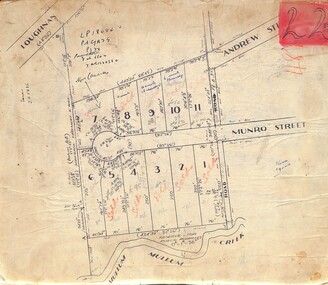
Map, Subdivision Plan of residential allotments in Munro Street, Ringwood, Victoria - (Undated, circa 1920s)
Map of residential allotments on cardboard backing.Handwritten notations include sales information and title references LP1884, Vol 6602, Fol 132038, with number of units on lots 8, 9 and 10. -
 Ringwood and District Historical Society
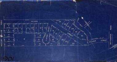
Map, Subdivision Plan of residential allotments in Mullum Mullum Road, Oliver Street and Lister Court, Ringwood, Victoria - (Undated)
Blueprint copy on cardboard backingNorth directional indicator includes name of Surveyor and Town Planner, Saxil Tuxen. -
 Ringwood and District Historical Society
Map, Subdivision Plan of residential allotments in Caroline Street, Thomas Street, Emerald Street and Ford Street, Ringwood, Victoria - (Undated, circa 1930)
Map of residential allotments on blue cardboard backing.Handwritten title reference notation LP13641. -
 Ringwood and District Historical Society
Map, Plan of Subdivision - State School Estate, Ringwood East, Victoria - (Undated, circa 1920s)
Map of land for sale attached to green cardboard backing with handwritten notations showing numbered allotments on Dublin Road, Holland Road, King Street, Charles Street and Purser Avenue, Ringwood East.Locality plan includes reference to proposed Ringwood East railway station which opened in 1925. -
 Ringwood and District Historical Society
Map, Two Partially Trimmed Copies of Ringwood Township Estate subdivision advertisement - 1919
Clippings on cardboard backing. Handwritten sales notations on numbered allotments in Ellison Street, Haig Street and Wantirna Road, Ringwood.One copy includes three oval rubber stamp impressions - F. Parker, Estate Agent, Ringwood. -
 Ringwood and District Historical Society
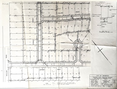
Document, Plan of Subdivision - Golden Wood Estate, Ringwood, Victoria - 1964
City of Ringwood drawing No.520 dated October 1964, for construction of Jeffrey Drive, Ronald Street, Golden Grove, Gilda Court and Jennifer Court, off Mullum Mullum Road, Ringwood.Consulting Engineers: Geoffrey C. Bird, 483 Collins Street, Melbourne (Tel) 62 1517. Principal: Commerce and Commission Victoria P/L. -
 Ringwood and District Historical Society
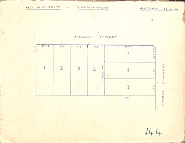
Map, Hand-drawn outline of residential allotments in Nelson Street and Ringwood Street, Ringwood, Vic., headed Mrs N.M. Adam - Subdivision - Auction 26.6.54
Pen drawing on cardboard backing. -
 Whitehorse Historical Society Inc.
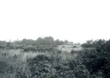
Photograph - B/W Photograph, Area North of Burwood Road near Dandenong Creek. For subdivision, 1971
Black and White Photo of Area North of Burwood Road near Dandenong Creek,dandenong, burwwd road -
 Ringwood and District Historical Society
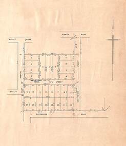
Map, Plan of Subdivision, Shasta Avenue, Merrilong Street, Northwood Street and Alexandra Road, Ringwood East, Victoria - (Undated, circa 1950s)
Printed map on light cardboard backing showing layout and dimensions of 20 residential allotments. -
 Whitehorse Historical Society Inc.
Document, Electoral roll, 1949
Electoral roll, Commonwealth Division of Latrobe, State Assembly District of Scoresby.Electoral roll, Commonwealth Division of Latrobe, State Assembly District of Scoresby. Roll of electors for the Subdivision of Mulgrave.Electoral roll, Commonwealth Division of Latrobe, State Assembly District of Scoresby. politics and government, electoral rolls -
 Ringwood and District Historical Society
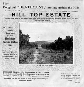
Pamphlet, Atlas Press Pty. Ltd., Melbourne, Land Sale Brochure, Hill Top Estate, Heathmont, Vic. - circa 1925
Twelve page land sale brochure promoting Heathmont and Ringwood area including photographs, subdivision features and local facilities. Subdivision plan includes Heathmont Road, Balfour Avenue, Edith Street, Edna Street, and Great Ryrie Street. -
 Ringwood and District Historical Society
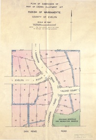
Document - Real Estate Folder, Savernake Estate, Ringwood, Victoria - Stage one - 1967
Plan of Subdivision, Part of Crown Allotment 31A and advertisement for sale of residential allotments with map showing layout of subdivision. Typewritten pricelist attached outlining suggested terms of sale as of 14 September, 1967.Subdivision includes Evelyn Road, Cameron Road, Klead Court, and San Remo Road. Agent - C.E. Carter & Son., 126 Whitehorse Road, Ringwood. (Phone) 87-6024, 87-6830, 870-2519, After hours: 723 3298, 878 2648. Subdivision Plan stamped Donald Cameron Consultants Pty. Ltd., Consulting Engineers, 472 Bourke Street Melbourne - 67-2602. -
 Kew Historical Society Inc
Plan - Subdivision : Cotham and Glenferrie Roads, J R Mathers & McMillan
The Kew Historical Society's map collection includes a substantial number of real estate subdivision plans, mainly of Kew but also of surrounding suburbs in Melbourne. Most of the subdivision plans date from the 1920s and 1930s when the districts old homes and local farmland were being split up to accommodate residential growth in the postwar period. These early plans were assembled by a local firm, Jas R Mather & McMillan, which had an office in Cotham Road. Many of the plans, and sometimes photos, were annotated by the agents.Subdivision plans are historically important documents used as evidence for the growth of suburbs in Australia. They frequently provide information about when the land was sold as well as evidence relating to surveyors and real estate and financial agents. The numerous subdivision plans in the Kew Historical Society's collection represent working documents, ranging from the initial sketches made in planning a subdivision to printed plans on which auctioneers or agents listed the prices for which individual lots were sold. In a number of cases, the reverse of a subdivision plan in the collection includes a photograph of a house that was also for sale by the agent. These photographs provide significant heritage information relating house design and decoration, fencing and household gardens.The photograph may also be aesthetically significant depending on the importance of the photographic atelier.An undated and untitled hand-drawn and coloured subdivision plan detailing the boundaries of a number of irregular allotments bordering Cotham Road, Glenferrie Road and Stirling Avenue (now Stirling Street). The plan predates the actual subdivision that led to the creation of the eight commercial properties occupying 118-132 Cotham Road. The plan may represent an old subdivision that was further subdivided at a later date, or it may be a subdivision that never eventuated. On MMBW Detail Plan 1575 (1903), the area represented by the proposed subdivision was residential rather than commercial. The irregularity of lots is also apparent in the MMBW Plan. The largest of the unnumbered blocks on the hand-drawn subdivision plan may relate to the boundaries of the nineteenth century mansion identified as ‘Kelso’ on the MMBW Plan.subdivision plans - kew, cotham road - kew,, glenferrie road - kew , stirling avenue street - kew -
Whitehorse Historical Society Inc.
Legal record - Land Title, Lemon Grove Nunawading, 1953
Certificate of Title: vol. 7827 fol. 071 to Tom SavageCertificate of Title: vol. 7827 fol. 071 to Tom Savage with transfers from October 1954 to 1970, recording subdivisionsCertificate of Title: vol. 7827 fol. 071 to Tom Savagesavage, tom, savage, grace beatrice, holmes, barbara ann, springfield road, nunawading, efron street, nunawading, savage court, nunawading, lemon grove, nunawading -
Bendigo Historical Society Inc.
Map - SUTTON GRANGE, 10th July 1872
Map: Residence sites at Sutton Grange, being subdivision of Allotment 10 Sec. 3, Parish of Sutton Grange (number 275 in map cupboard 1)map, subdivision, sutton grange, residence sites, allotment 10 sec. 3 -
 Ringwood and District Historical Society
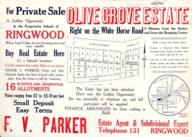
Flyer, Land Sale Advertisement, Olive Grove Estate, Ringwood, Vic. - 1926
Further development of 9 shop sites took place along Whitehorse Road (later street numbers 58 to 64 Whitehorse Road) between New Street and Olive Grove around 1950 - See Victorian Collections reference 5227.Single sided page with red and blue print advertising Olive Grove Estate business and residential allotments, including subdivision plan and summary of local services.Subdivision includes Whitehorse Road, New Street, and Olive Grove. Agent - F.V. Parker, Telephone 131, Ringwood. -
 Ringwood and District Historical Society
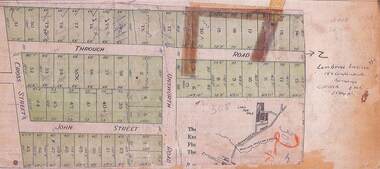
Flyer, Land Sale Advertisement - Unsworth Winmarleigh Estate, Ringwood, Victoria - circa 1912
Advertisement and attachment for subdivision of land adjoining Warrandyte Road coach route in North Ringwood, with map showing layout of subdivision, summary of local features and services, and terms of sale. Subdivision includes Wonga Road (later Loughnan Road & Warrandyte Road), Unsworth Road, Through Road, Cross Street, and John Street. Contacts - Mrs Unsworth on the Estate or W.M. Unsworth, 58 Little Latrobe Street, Melbourne, Telephone Central 7207. -
 Ringwood and District Historical Society
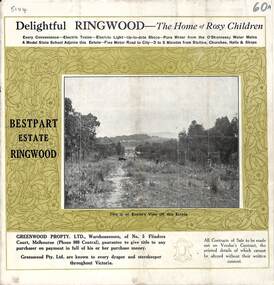
Pamphlet, Land Sale Brochure, Bestpart Estate, Ringwood - circa 1925
Twelve page land sale brochure including photographs, subdivision features and local facilities. Additional flyer with conditions of sale and prices for estate blocks.Subdivision plan includes Bedford Road, Greenwood Avenue, Caroline Street, Wilanna Street, Henry Street, Haig Street -
 City of Kingston
Pamphlet - Colour, Roy Dunn Pty. Ltd, Central Corner Estate Moorabbin and Highett, c. 1923
Sales plan for land in the suburbs of Highett and Moorabbin, bordered by Point Nepean Road and Wickham Road East incorporating William StreetThe developing urban area of Highett and Moorabbin within the City of Kingston. This land sale pamphlet illustrates the subdivision of land within the municipality and the changing demographic of the district as new houses are constructed close to infrastructure.Colour pamphlet advertising for private sale land in the Central Corner Estate in Moorabbin and Highett. Incorporates a map of the estate bordered by Point Nepean Road and Wickham Road East, with subdivisions also available on both sides of William Street. Handwritten in blue pencil on subdivision plan: a tick is drawn on subdivisions 2-18 Handwritten in blue pencil on subdivision 6: a box with an x inside Handwritten in blue pencil on subdivisions 10 and 12: S Handwritten in black ink on front page: [indecipherable] / McKittricks Handwritten in grey pencil on rear page: McKilhick / Nepean Rd Handwritten in grey pencil on rear page upside down: 160000 / 15 8300 [crossed out] land sales, estate, highett, moorabbin -
 Ringwood and District Historical Society
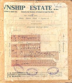
Flyer, Land Sale Advertisement - Roebury Estate, Ringwood, Victoria - circa 1938
Advertisement for sale of residential allotments with map showing location and layout of subdivision, terms of sale, and summary of local features and services.Subdivision includes Dublin Road, Alexander Road, and Ferntree Gully Road (later Bedford Road). Agent - J.B. McAlpin, Opposite Railway Station, Ringwood. -
 City of Kingston
Pamphlet - Colour, J. F. Brady, Matthiesson's Estate, Highett, c. 1905
Sales plan for land in the suburb of Highett, bounded by Tennyson Street, James Street and Point Nepean Road and including Maher Street, Connors Street, Enright Street, Edward Street, James Street and Matthieson Street.The developing urban area of Highett within the City of Kingston. This land sale pamphlet illustrates the subdivision of land within the municipality and the changing demographic of the district as new houses are constructed close to infrastructure.Colour pamphlet advertising for private sale subdivisions in the Matthiesson's Estate, Highett. Incorporates a map of the estate bordered by Tennyson Street, James Street and Point Nepean Road and including Maher Street, Connors Street, Enright Street, Edward Street, James Street and Matthieson Street.Handwritten in blue pencil: x marked on every subdivision on the map Handwritten in grey pencil at the end of the Price List: x not sold Handwritten in grey pencil adjacent to subdivisions 58, 167 and 166: JP. Turner Handwritten in grey pencil adjacent to subdivision 164: [indecipherable] Markings in grey pencil around the edges of the subdivision map Handwritten in grey pencil on reverse: Matthiesson / Matthiesson Estate / Matthiesson Estateland sales, estate, highett -
 Kew Historical Society Inc
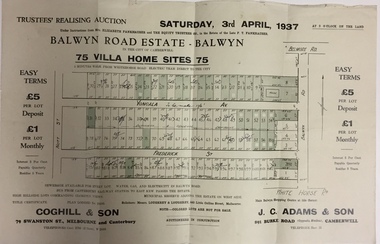
Plan - Subdivision Plan, Balwyn Road Estate, Balwyn (1937), 1937
Historic subdivision in Balwyn, VictoriaSubdivision Plan of Balwyn Road Estate (Balwyn). Held in April 1937, the auction included 102 lots for sale in Yongala Avenue, Young Street, and Balwyn RoadInscriptions on individual lots by agentsubdivision plans - balwyn (vic), balwyn road estate - balwyn -
Whitehorse Historical Society Inc.
Document, Certificate of Title, 1924, 1933
Certificate of Title: Edmund Francis ShapleyCertificate of Title: Edmund Francis Shapley, Lot 277 subdivision 3051 Parish of Nunawading Vol.4945 Fol. 988875 1924., Certificate of Title: Myra Constance Agnes Robinson Lot 278 Subdivision 3051. As above. Vol 4945 Fol,988876 1924, Rates - enforcement of charge 1933 & rates enforcement charge 1933.Certificate of Title: Edmund Francis Shapleyland titles, shire of nunawading, shire of blackburn, mitcham, shapley, edmund francis, robinson, myra constance agnes, alfred street blackburn -
Whitehorse Historical Society Inc.
Map, Gill's Springfield Road Estate, 1950?
Plan of subdivision for Gill's Springfield Road Estate, former orchard, 16 lots.Plan of subdivision for Gill's Springfield Road Estate, former orchard, 16 lots. Reprinted by Real Estate Agent, Spencer Jackson.Plan of subdivision for Gill's Springfield Road Estate, former orchard, 16 lots. land subdivision, norway avenue, blackburn, springfield road, blackburn, beverley crescent, blackburn, kevin avenue, blackburn, kerr street, blackburn, bordeaux avenue, blackburn, gill's estate, orchards, spencer jackson -
 Ringwood and District Historical Society
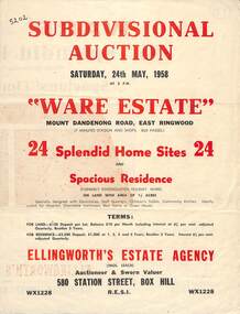
Flyer, Subdivisional Auction Sale Brochure, Ware Estate, East Ringwood, Vic. - 1958
Folded double-sided advertisement for auction of 24 home sites and existing residence on Saturday, 24th May, 1958, including locality map, subdivision layout, terms of sale, and summary of local facilities and services. Additional plan of lots 28-33 dated 26/10/60 by Licensed Surveyor for Kirkpatrick & Webber, 225 Maroondah Highway Ringwood headed Plan of Subdivision of part of Crown Allotment 26A Parish of Ringwood.Subdivision includes Mount Dandenong Road, Ware Crescent, Davey Drive, and Grey Road (later Grey Street). Timber residence included in the subdivision was formerly Ware Kindergarten Holiday Home. (Agent) Ellingworth's Estate Agency, 580 Station Street, Box Hill - (Phone) WX1228. -
 Kew Historical Society Inc
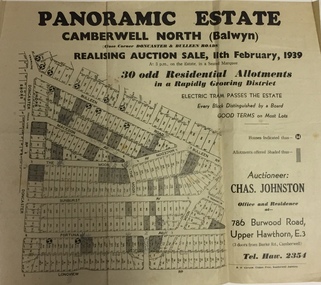
Plan - Subdivision Plan, Panoramic Estate, Camberwell North (Balwyn), 1939, 1939
Subdivision plan advertised as the Panoramic Estate, Balwyn, showing lots for sale in the following streets: Bulleen Road, Macedon Avenue, The Moor, Sunburst Avenue, Doncaster Road, Fortuna Avenue, Longview Road, The Nook, and Touring Avenue.Single page subdivision plan of the Panoramic Estate in Camberwell North (Balwyn); offered for sale in 1939Nilsubdivision plans - balwyn (vic), panoramic estate - camberwell north - balwyn (vic)