Showing 404 items
matching tambo
-
 Lakes Entrance Historical Society
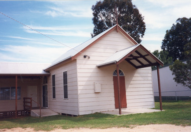
Photograph - Union Church Nicholson, 1999
Built 1890, used as Church until August 1970, ministers of Congregational Methodist and Anglican taking services and ceremonies. In 1971 it was given to Tambo Shire as a Recreation Hall for the people of Nicholson.Colour photograph of Nicholson Union Church and Hall, Princes Highway, showing a small building, clad in Hardiplank or similar material, gable roof, with additions at right angle at rear. Nicholson Victoriareligion, buildings -
 Orbost & District Historical Society
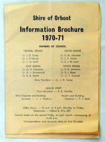
brochures, Snowy River Mail as "Mail" Print, Shire of Orbost Information Brochure, December 1970
The Shire of Orbost was a local government area about 380 kilometres east of Melbourne, the state capital of Victoria, Australia. The shire covered an area of 9,347 square kilometres ), and existed from 1892 until 1994. Originally, Orbost was part of the Bairnsdale Road District which was created on 30 April 1867. Splitting away as part of the Shire of Tambo in 1882, Orbost was first incorporated as a shire in its own right as the Shire of Croajingolong on 30 May 1892. It received its present name on 17 February 1893. On 3 January 1913 part of its western riding was annexed to Tambo as its Cunninghame Riding. On 2 December 1994, the Shire was abolished, and merged with City and Shire of Bairnsdale, Shire of Tambo, most of Shire of Omeo and the Boole Boole Peninsula from Shire of Rosedale into the Shire of East Gippsland This is a useful research tool.Two copies of a triple fold paper brochure. It is titled"Shire of Orbost Information Brochure" in black print. It contains the names of councillors, staff, the work program and budget.shire-of-orbost -
 Orbost & District Historical Society
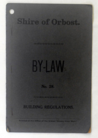
booklet, Snowy River Mail, Shire of Orbost By Laws No 28, 1920's
This booklet contains by law No 28 pertaining to building regulations. The Shire of Orbost was a local government area about 380 kilometres east of Melbourne, the state capital of Victoria, Australia. The shire covered an area of 9,347 square kilometres ), and existed from 1892 until 1994. Originally, Orbost was part of the Bairnsdale Road District which was created on 30 April 1867. Splitting away as part of the Shire of Tambo in 1882, Orbost was first incorporated as a shire in its own right as the Shire of Croajingolong on 30 May 1892. It received its present name on 17 February 1893. On 3 January 1913 part of its western riding was annexed to Tambo as its Cunninghame Riding. On 2 December 1994, the Shire was abolished, and merged with City and Shire of Bairnsdale, Shire of Tambo, most of Shire of Omeo and the Boole Boole Peninsula from Shire of Rosedale into the Shire of East Gippsland. This item is a useful research tool.A dark grey, stapled, paper covered booklet with title "Shire of Orbost By Law No 28" in black print. -
 Orbost & District Historical Society
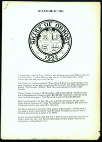
information sheet, Welcome to the Shire of Orbost, 1992
This was possibly produced for an open day in the centenary year. The Shire of Orbost was a local government area about 380 kilometres east of Melbourne. The shire covered an area of 9,347 square kilometres and existed from 1892 until 1994. Originally, Orbost was part of the Bairnsdale Road District which was created on 30 April 1867. Splitting away as part of the Shire of Tambo in 1882, Orbost was first incorporated as a shire in its own right as the Shire of Croajingolong on 30 May 1892. It received its present name on 17 February 1893. On 3 January 1913 part of its western riding was annexed to Tambo as its Cunninghame Riding. On 2 December 1994, the Shire was abolished, and merged with City and Shire of Bairnsdale, Shire of Tambo, most of the Shire of Omeo and the Boole Boole Peninsula from Shire of Rosedale into the Shire of East Gippsland. This is a useful reference tool.Two stapled pages of printed information. On the front page is the logo of Orbost Shire Council. There is information on the role of the Shire Councillors for 1992/93. It has a map of the council building.orbost-shire-council -
 Lakes Entrance Historical Society
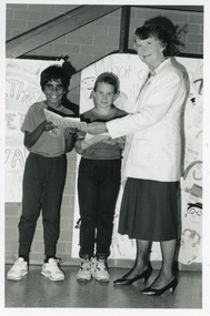
Photograph - St Brendans Primary School, Lakes Post Newspaper, 1993
Black and white photograph of Adam Hayes Reannon Conduit from St Brendans and Primary Schools, presenting Cr Margot Kerby of Tambo Shire Council with letters of support for a swimming pool at Lakes Entrance Victoriaschools, fundraising, officials -
 Lakes Entrance Historical Society
Book, Campbell Kenneth W, 100 Years of Saints and Sinners The Centenary History of the Anglican Parish of Bruthen in East Gippsland, 1992
A centenary history of St Matthews Anglican Parish of Bruthen,Victoria which includes history and development of the region, establishment of the Church, priests and lay readers, and the other communities served, ie Sarsfield, Wiseleigh, Mossiface, Tamboreligion, township -
 Lakes Entrance Historical Society
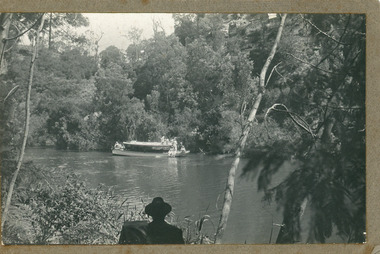
Photograph - MV Maranui, 1930 c
Black and white photograph showing Broomes launch Maranui in Tambo River (?) Thick vegetation on either bank. Several people on boat, one man centre lower edge on the bank watching. Swan Reach VictoriaBroome's Launch (written on back)waterways, boats and boating, tourism -
 Lakes Entrance Historical Society
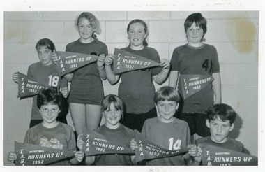
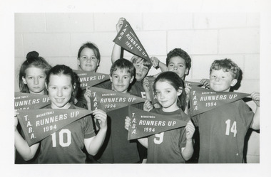
Photograph - Johnsonville School, Lakes Post Newspaper, 1992
Black and white photograph of eight named children from Johnsonville Primary School Basketball team Runners-Up Tambo Rural Schools competition each child holding a pennant flag. Lakes Entrance Victoriaschools, sports -
 Lakes Entrance Historical Society
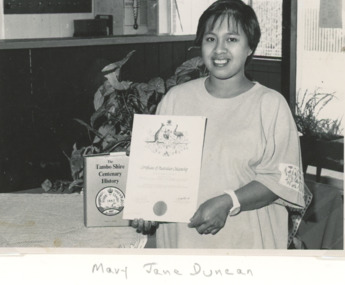
Photograph - Australian Citizenship, Lakes Post Newspaper, Mary Jane Duncan holding her Australian Citizenship Certificate, 1/05/1991 12:00:00 AM
Black and white photograph showing Mary Jane Duncan holding her Australian Citizenship Certificate after the award ceremony in May 1991 at the Tambo Shire Civic Centre Palmer's Road Lakes Entrance Victoriaceremony, certificates, events -
 Lakes Entrance Historical Society
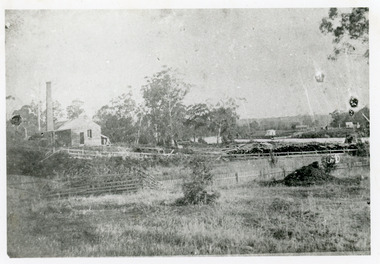
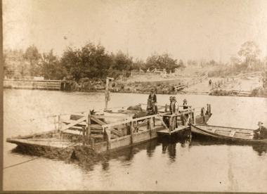
Photograph - Johnsonville Creamery, 1895
Original creamery was at Bruthen, ,shifted to Johnsonville in March 1892, run by the Chilled Butter Company until 1899 with Mr G Lucas, last manager.Black and white photograph of the Johnsonville Creamery, situated on the southern bank of the Tambo River on Punt Road. A small timber building with gable roof, large chimney adjacent, punt landing and roadway on opposite bank. Johnsonville Victoriadairying, primary industry -
 Lakes Entrance Historical Society
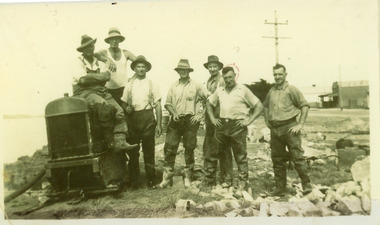
Photograph, 1930c
Men - from right- F Worseldine, R Martin, E Bourke, B SmithBlack and white photograph snapshot of Tambo Shire workers constructing retaining wall along Cunninghame Arm, after WW1. Four men on right. Photograph presumed to be opposite present McDonald's restaurant. Lakes Entrance Victoria waterfront, maintenance -
 Lakes Entrance Historical Society
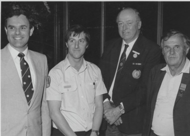
Photograph - Fire Brigade, Lakes Post Newspaper, 1991
Black and white photograph Tambo Group Fire Brigade Awards, Colin Watt Regional Officer, Ken Whadcoat, Alex Cooper and Colin Campbell awarede National Medal and Clasp for 30 years. Lakes Entrance Victoriafire brigade, volunteering -
 Lakes Entrance Historical Society
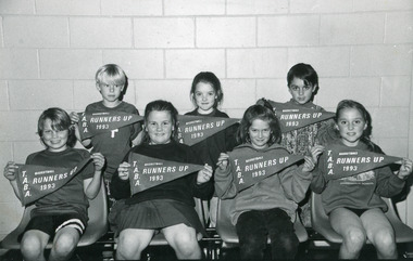
Photograph - Johnsonville State School, Lakes Post Newspaper, 1993
Photograph taken and competition played at Lakes Entrance Recreation Centre..Black and white photograph of seven named children from Johnsonville Primary School Basketball Team Runners-Up, in Tambo Rural Schools Cluster competition each child is holding a pennant flag. Lakes Entrance Victoriaschools, sports -
 Lakes Entrance Historical Society
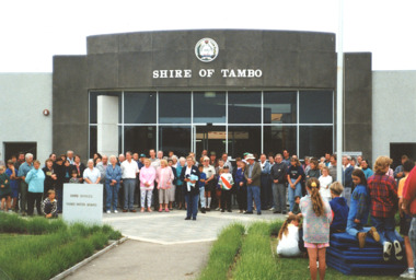
Photograph - Closing of Shire of Tambo 1994, Marie Fish, 1/11/1994 12:00:00 AM
Local Councils were amalgamated to form East Gippsland Shire Council in 1994Colour photograph of closing ceremony for Shire of Tambo showing crowd outside Shire Offices Palmer Road Lakes Entrance Victoria. Second colour photograph taken after same event shows crowd at barbeque van local government, choir -
 Orbost & District Historical Society
black and white photograph, before 1924
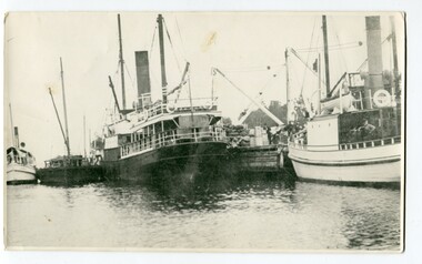
This photograph shows the Lady Harriett, her barge, the Wyrallah and Storm Bird with Captain Jimmy Bills at Harbeck's wharf, Lakes Entrance, The Lady Harriett was a small steamer that serviced the Tambo River and other areas. In 1895 the Lady Harriett was advertised to run between Bairnsdale and Mallacoota on a weekly service. The Lady Harriett and barge did two or three trips up the Tambo per week. She did not carry passengers or run to a timetable and would carry maize and beans as well as fish from Mallacoota where by 1900 the fishing industry was well established' Lady Harriett towed her barge carrying an assortment of goods up the Tambo from 1895 to 1913. The S.S. Wyrallah was a regular Melbourne header for over twenty years. She was run down and sunk by the steamer Dilkera with the loss of six lives at Port Philip Head. (ref. The Argus Friday April 11 1924)This is a pictorial record of a once busy wharf. From Lakes Entrance ocean-going vessels had access to the Gippsland Lakes, the largest navigable inland waterway in Australia.A large black / white photograph of two large ships and two smaller ones at a wharf. There are people on the wharf and on the boats.on back - "Jo-Bull", L-R Lady Harriet.........."lady-harriett s.s.-wyrallah shipping-east-gippsland harbeck's-wharf-lakes-entrance sea-transport -
 Orbost & District Historical Society
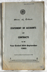
statement of accounts, Shire of Orbost Statement of Accounts, 1963
This document was made by the Shire of Orbost, local government. The Shire of Orbost was a local government area about 380 kilometres (236 mi) east of Melbourne, the state capital of Victoria, Australia. The shire covered an area of 9,347 square kilometres (3,608.9 sq mi), and existed from 1892 until 1994. Originally, Orbost was part of the Bairnsdale Road District which was created on 30 April 1867. Splitting away as part of the Shire of Tambo in 1882, Orbost was first incorporated as a shire in its own right as the Shire of Croajingolong on 30 May 1892. It received its present name on 17 February 1893. On 3 January 1913 part of its western riding was annexed to Tambo as its Cunninghame Riding. On 2 December 1994, the Shire was abolished, and merged with City and Shire of Bairnsdale, Shire of Tambo, most of Shire of Omeo and the Boole Boole Peninsula from Shire of Rosedale into the Shire of East Gippsland. Local governments play an important role in the lives of citizens in Australia. Local government authorities exist to provide services and amenities to local communities, and are also responsible for regulating and providing services for land and property in their district. This item is representative of a time when Orbost had its own Shire Council. A document with a light blue cover, black print. It is a "statement of accounts for the Shire of Orbost for the year ended 30th September, 1963".document-statement-of-accounts orbost-shire -
 Orbost & District Historical Society
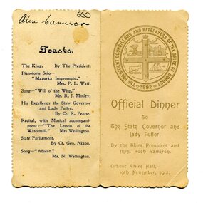
menu, 1912
This item is an invitation to a dinner given by the Shire President and Mrs Hugh Cameron for the State Governor and Lady Fuller to be held in the Orbost Shire Hall on November 19, 1912. The governor and his wife left Melbourne on November 14 on a visit to East Gippsland. Hugh Cameron (1850-1921) was on the Orbost Shire council from 1892-1915. (more info. in O.D.H.S. newsletter -Tambo Shire) The Shire of Orbost was a local government area about 380 kilometres east of Melbourne, the state capital of Victoria, Australia. The shire covered an area of 9,347 square kilometres (3,608.9 sq mi), and existed from 1892 until 1994. Originally, Orbost was part of the Bairnsdale Road District which was created on 30 April 1867. Splitting away as part of the Shire of Tambo in 1882, Orbost was first incorporated as a shire in its own right as the Shire of Croajingolong on 30 May 1892. It received its present name on 17 February 1893. On 3 January 1913 part of its western riding was annexed to Tambo as its Cunninghame Riding. On 2 December 1994, the Shire was abolished, and merged with City and Shire of Bairnsdale, Shire of Tambo, most of Shire of Omeo and the Boole Boole Peninsula from Shire of Rosedale into the Shire of East Gippsland. This item is associated with Orbost Shire Council which no longer exists. It is also associated with Hugh Cameron.A small menu on a cream folded card with blue print. On the front is stamped a large blue logo of the Shire of Orbost. The text is "Official Dinner". On the back is a list of toasts and inside is the menu.On back - handwritten - "Alex Cameron"orbost-shire-council cameron-hugh -
 Orbost & District Historical Society
dress
This dress is from the estate of James Cameron who was one of the first Snowy River councillors for the Tambo Shire. He selected land at Lochiel in 1892. From 1902-1920 he was the Assembly member for East Gippsland.Long black silk dress with long sleeves. It is hand-made - machine stitched. There is black beading around the neck and collar. The belt is also beaded. There are small black buttons on the belt and sleeves. It has a black underskirt.costum -female cameron -
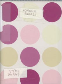 Lakes Entrance Historical Society
Album, LERHS members, Honour Boards from East Gippsland Victoria, 2010
Photographs of Honour Boards from around Gippsland. Includes Bruthen, Omeo, Glen Valley, Lakes Entrance, Kalimna, Swan Reach, Tambo Upper, Lake Tyers Rd School, Briagalong, Swifts Creek, TarravilleA small album containing photographs of Honour Boards from East Gippsland Victoria. Please visit L.E. History Centre to view all photos. schools, ww1, ww2, memorials -
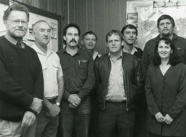 Lakes Entrance Historical Society
Photograph - Tambo Water Board, Lakes Post Newspaper, 1993
Black and White Photograph of Seven members of Tambo Water Board , John Hitchison, , Alf Coleman, Wayne Stewart, Brian White, Gerry Thorn, Tim Froud, Tony McKean, Marlene Battista 1996 Lakes Entrance Victoriawater resources, local government -
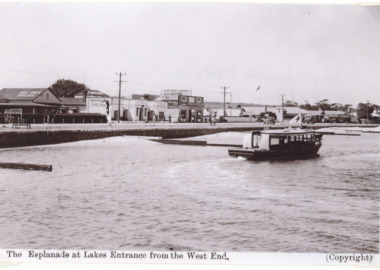 Lakes Entrance Historical Society
Photograph - MV Blackbird, H D Bulmer, Peels tourist launch Blackbird, Lakes Entrance Victoria, 1940 c
Black and white photograph of postcard of Peels tourist launch Blackbird in Cunninghame Arm opposite Kia Ora House Lakes Entrance Victoria. Also a black and white photograph of Peels launch Blackbird in the Tambo River East GippslandThe Esplanade at Lakes Entrance from the West Endtourism, boats and boating -
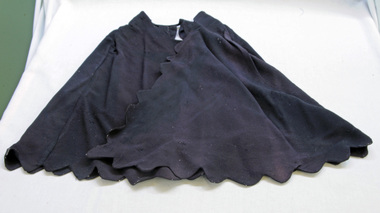 Orbost & District Historical Society
cape, Before 1922
This cape comes from the estate of James Cameron who was one of the first Snowy River councillors for the Tambo Shire. He selected land at Lochiel in 1892. From 1902-1920 he was the Assembly member for East Gippsland.A black shoulder cape made of crepe silk. It has scalloped edges and is probably hand-made. It fastens with press studs and the hems have been machined.cape silk clothing -
 Orbost & District Historical Society
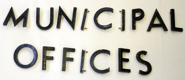
metal letters, Before 1969
These letters are from the Shire Office prior to its amalgamation to East Gippsland. They were located directly above the front doors at the front entrance to the building. The Shire coat of arms was on the wall on the right of the front entrance to the building directly above the front doors. The current building was opened on Friday 28th February 1969 by the Premier of Victoria, The Hon. Sir Henry E. Bolte, K.C.M.G., M.P. Originally, Orbost was part of the Bairnsdale Road District which was created on 30 April 1867. Splitting away as part of the Shire of Tambo in 1882, Orbost was first incorporated as a shire in its own right as the Shire of Croajingolong on 30 May 1892. It received its present name on 17 February 1893. On 3 January 1913 part of its western riding was annexed to Tambo as its Cunninghame Riding. On 2 December 1994, the Shire was abolished, and merged with City and Shire of Bairnsdale, Shire of Tambo, most of Shire of Omeo and the Boole Boole Peninsula from Shire of Rosedale into the Shire of East Gippsland. Sixteen metal letters - M U N I C I P A L O F F I C E S They are probably painted aluminium.municipal orbost-shire-council government -
 Lakes Entrance Historical Society
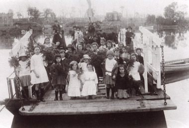
Photograph - Johnsonville Punt, 1921
Black and white photograph of the Johnsonville State School students posed on the Johnsonville Punt moored to the bank of the Tambo River. Many of the children are holding bunches of greenery, perhaps, indicating Arbor Day. Some adults also present. Johnsonville Victoria waterways, schools, transport -
 Lakes Entrance Historical Society
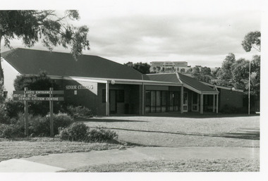
Photograph - Senior Citizen's Centre, 1989
Built on part of former Primary School pine plantation.Colour photograph of Lakes Entrance Seniors Club Rooms at Coates Road, showing a brick building with hip roof. Ramp to side entry, main entry on east side. Tambo Shire Offices on hill in background. Lakes Entrance Victoriacommunity facilities, recreation -
 Lakes Entrance Historical Society
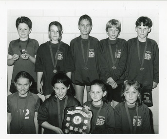
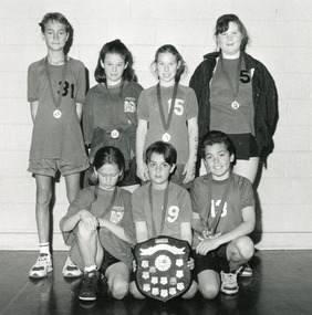
Photograph - Johnsonville School, Lakes Post Newspaper, 1994
Photograph taken and competition played at Lakes Entrance Recreation Centre.Black and white photographof nine named children from Johnsonville Primary School Basketball team A Grade winners Rural Schools Tambo Cluster competition each child has medal on a ribbon around their neck. Lakes Entrance Victoriaschools, sports -
 Lakes Entrance Historical Society
Photograph - Johnsonville School, Lakes Post Newspaper, 1995
Photograph taken and competition played at Lakes Entrance Recreation Centre.Black and white photograph of seven named children from Johnsonville Primary School students, A Grade Basketball team Tambo Cluster Rural Schools competition each child has medal on a ribbon around their neck. Lakes Entrance Victoriaschools, sports -
 Orbost & District Historical Society
dress
This dress and petticoat come from the estate of James Cameron who was one of the first Snowy River councillors for the Tambo Shire. He selected land at Lochiel in 1892. From 1902-1920 he was the Assembly member for East Gippsland.A white voile dress with a white cotton petticoat underneath. It is not attached. The dress has a lace frill at the hem. It has lace inserts - two at the bodice and along the three-quarter length sleeves. There are several lace inserts on the skirt. It has been machine embroidered.dress costume cameron-james -
 Lakes Entrance Historical Society
Photograph - Johnsonville State School, Lake Post Newspaper, 1994
Competition played at Lakes Entrance Recreation Centre.Black and white photograph of eight named children from Johnsonville Primary School Basketball Team B Grade Runners-Up, from the Tambo Cluster Rural Schools competition, each child is holding a pennant flag. Lakes Entrance Victoriaschools, sports -
 Lakes Entrance Historical Society
Photograph - Johnsonville Punt, Hancock, Phillip, 1920
Also black and white 10 x 15 cm copy donated by M Holding January 2012Sepia toned copy of a postcard showing the punt at the Tambo River, one man on horse, three men standing, cattle penned on punt, one man in rowing boat tied to punt. Jetty near landing on far bank of river. Johnsonville Victoria waterways, transport, animals, boating