Showing 307 items matching "water scheme"
-
 Wodonga & District Historical Society Inc
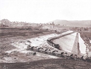
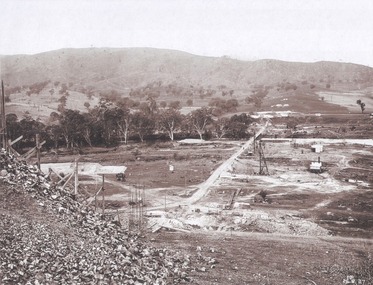
Album - Hume Reservoir Australia Album - Concrete Slabs on embankment, August 1927
This set of photos is from a leather bound album bearing the inscription "HUME RESERVOIR AUSTRALIA" plus 'The Rt. Hon. L. C. M. S. Amery, P. C., M .P.' all inscribed in gold. It was presented to The Rt. Hon. L. C. M. S. Amery, P. C., M. P, Secretary of State for Dominion Affairs on the occasion of his visit to the Hume Reservoir on 2nd November 1927. This album is of local and national significance as it documents the planning and development of the Hume Reservoir up to 1927. It was the largest water reservoir in the British Empire. The album records the pioneering engineering work that went into its construction.DEPARTMENT OF PUBLIC WORKS, N.S.W. RIVER MURRAY WATERS SCHEME. HUME RESERVOIR. 33. Concrete Slabs on Embankment. The upstream face of the embankment is being protected from the effects of wave action by concrete slabs 12 inches thick laid in squares in situ. The thrust at the toe of the bank is taken care of by a body of granite blocks and spalls. Victoria. August 1927.hume reservoir australia, river murray waters scheme, hume reservoir construction -
 Wodonga & District Historical Society Inc
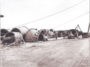
Album - Hume Reservoir Australia Album - Needle valves, August 1927
This set of photos is from a leather bound album bearing the inscription "HUME RESERVOIR AUSTRALIA" plus 'The Rt. Hon. L. C. M. S. Amery, P. C., M .P.' all inscribed in gold. It was presented to The Rt. Hon. L. C. M. S. Amery, P. C., M. P, Secretary of State for Dominion Affairs on the occasion of his visit to the Hume Reservoir on 2nd November 1927. This album is of local and national significance as it documents the planning and development of the Hume Reservoir up to 1927. It was the largest water reservoir in the British Empire. The album records the pioneering engineering work that went into its construction.DEPARTMENT OF PUBLIC WORKS, N.S.W. RIVER MURRAY WATERS SCHEME. HUME RESERVOIR. 34. Needle Valves. Some of the needle valves in parts stacked ready for removal by the cableway to their positions on the outlets. There are seven of these, 7 feet 6 inches in diameter. The heaviest single part weighs about 10 tons. New South Wales. August 1927. A needle valve is a type of valve which can be used to regulate flow of a substance, usually either gas or water, through an appliance or system. The unique feature of the value is the inclusion of a small plunger, with a shape akin to a needle.hume reservoir australia, river murray waters scheme, hume reservoir construction -
 Wodonga & District Historical Society Inc
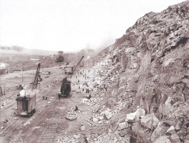
Album - Hume Reservoir Australia Album - View along the face of the quarry, August 1927
This set of photos is from a leather bound album bearing the inscription "HUME RESERVOIR AUSTRALIA" plus 'The Rt. Hon. L. C. M. S. Amery, P. C., M .P.' all inscribed in gold. It was presented to The Rt. Hon. L. C. M. S. Amery, P. C., M. P, Secretary of State for Dominion Affairs on the occasion of his visit to the Hume Reservoir on 2nd November 1927. This album is of local and national significance as it documents the planning and development of the Hume Reservoir up to 1927. It was the largest water reservoir in the British Empire. The album records the pioneering engineering work that went into its construction.DEPARTMENT OF PUBLIC WORKS, N.S.W. RIVER MURRAY WATERS SCHEME. HUME RESERVOIR. 35. Quarry. View along the face of the quarry. Granite is being quarried here for the concrete material. Blocks from 2-8 tons in weight are reserved for “plums”. Quantities of large size spalls are sent to Victoria for the toe of the embankment and other purposes but the greatest proportion of the stone is crushed at the quarry to 2½ inches gauge for concrete aggregate. Two steam navvies and two steam travelling cranes are at work on the face. New South Wales. August 1927.hume reservoir australia, river murray waters scheme, hume reservoir construction -
 Wodonga & District Historical Society Inc
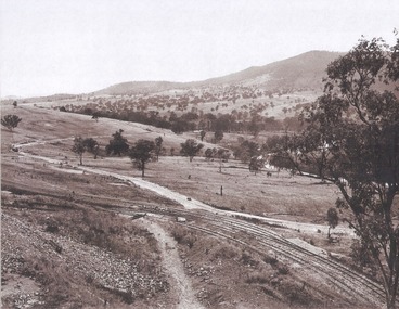
Album - Hume Reservoir Australia Album - Valley of the Murray to be crossed by the Bethanga Bridge 1927
This set of photos is from a leather bound album bearing the inscription "HUME RESERVOIR AUSTRALIA" plus 'The Rt. Hon. L. C. M. S. Amery, P. C., M .P.' all inscribed in gold. It was presented to The Rt. Hon. L. C. M. S. Amery, P. C., M. P, Secretary of State for Dominion Affairs on the occasion of his visit to the Hume Reservoir on 2nd November 1927. This album is of local and national significance as it documents the planning and development of the Hume Reservoir up to 1927. It was the largest water reservoir in the British Empire. The album records the pioneering engineering work that went into its construction.DEPARTMENT OF PUBLIC WORKS, N.S.W. RIVER MURRAY WATERS SCHEME. HUME RESERVOIR. 36. Valley of the Murray to be crossed by the Bethanga Bridge described in the next photograph. (WHS 00731) This view shows the marshalling sidings for trucks below the Quarry, New South Wales, and the branch line to the site of the bridge.hume reservoir australia, river murray waters scheme, hume reservoir construction -
 Wodonga & District Historical Society Inc
Album - Hume Reservoir Australia Album - Bethanga Bridge Site, August 1927
This set of photos is from a leather bound album bearing the inscription "HUME RESERVOIR AUSTRALIA" plus 'The Rt. Hon. L. C. M. S. Amery, P. C., M .P.' all inscribed in gold. It was presented to The Rt. Hon. L. C. M. S. Amery, P. C., M. P, Secretary of State for Dominion Affairs on the occasion of his visit to the Hume Reservoir on 2nd November 1927. This album is of local and national significance as it documents the planning and development of the Hume Reservoir up to 1927. It was the largest water reservoir in the British Empire. The album records the pioneering engineering work that went into its construction.DEPARTMENT OF PUBLIC WORKS, N.S.W. RIVER MURRAY WATERS SCHEME. HUME RESERVOIR. 37. Bethanga Bridge Site. A bridge is being built to cross the Reservoir to serve a large area of country which will be cut off from its natural outlets by the submergence of existing bridges when the Reservoir is in being. The site of the bridge is nearly a mile up the Murray from the Hume Reservoir Quarry. Its length will be approximately half a mile. There will be nine spans of 269 feet with steel truss girders resting on concrete pillars. Some of the pillars are founded on rock while others will rest on nests of reinforced concrete piles. The foundations and concrete piers are in the hands of the Victorian Constructing Authority and the superstructure in those of the New South Wales Authority. August 1927.hume reservoir australia, river murray waters scheme, hume reservoir construction -
 Wodonga & District Historical Society Inc
Booklet - Victoria's Upper Kiewa Valley, State Electricity Commission, C. 1984
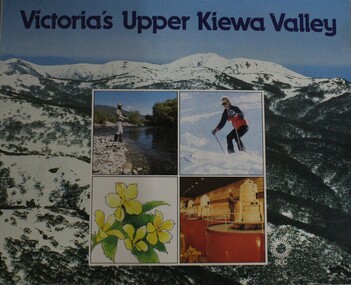
... The Kiewa Hydro Electric Scheme is the largest water power... The Kiewa Hydro Electric Scheme is the largest water power ...This booklet is one of several publications from the State Electricity Commission during the period it was responsible for the running of the Kiewa Hydro Electric Scheme. It promotes tourism and depicts key features of the region in the 1980s.non-fictionThis booklet is one of several publications from the State Electricity Commission during the period it was responsible for the running of the Kiewa Hydro Electric Scheme. It promotes tourism and depicts key features of the region in the 1980s.victoria. kiewa valley, kiewa river valley (vic.) -- description and travel., kiewa hydro -
 Wodonga & District Historical Society Inc
Book - Mud Sweat and Snow: Memories of Snowy Workers 1949-1959, Noel Gough, 1994
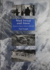
This book tells the human story of the first decade of building the great Snowy Mountains Hydro-Electric Scheme, with adventures and anecdotes told by the workers themselves, and illustrated with unusual photographs. Appendices give further information about the project and list the workers named in Snowy records. The author began his 10 years with the Electrical and Mechanical Division at the age of 20. The construction of the Snowy Mountains Hydro-electric Scheme is a well-documented part of our nation’s history and a leading example of Australian innovation and ingenuity. As far back as the 1880s, Australians had been considering diverting water from some of Australia’s best-known rivers – the Murray, Murrumbidgee, Snowy and Tumut – to drought-proof parts of NSW and Victoria. It was not until 1944 that Commonwealth and State governments formed a committee to examine the development of water resources in the Snowy Mountains area. As a result of their work, on 7 July 1949, the Commonwealth Parliament passed legislation to establish a Statutory Authority and start construction of the Snowy Scheme. NSW. Construction was completed in 1974 at a total cost of $820 million. On completion, the Scheme consisted of seven power stations, 16 major dams, 80 kilometres of aqueducts and 145 kilometres of interconnected tunnels.non-fictionThis book tells the human story of the first decade of building the great Snowy Mountains Hydro-Electric Scheme, with adventures and anecdotes told by the workers themselves, and illustrated with unusual photographs. Appendices give further information about the project and list the workers named in Snowy records. The author began his 10 years with the Electrical and Mechanical Division at the age of 20. The construction of the Snowy Mountains Hydro-electric Scheme is a well-documented part of our nation’s history and a leading example of Australian innovation and ingenuity. As far back as the 1880s, Australians had been considering diverting water from some of Australia’s best-known rivers – the Murray, Murrumbidgee, Snowy and Tumut – to drought-proof parts of NSW and Victoria. It was not until 1944 that Commonwealth and State governments formed a committee to examine the development of water resources in the Snowy Mountains area. As a result of their work, on 7 July 1949, the Commonwealth Parliament passed legislation to establish a Statutory Authority and start construction of the Snowy Scheme. NSW. Construction was completed in 1974 at a total cost of $820 million. On completion, the Scheme consisted of seven power stations, 16 major dams, 80 kilometres of aqueducts and 145 kilometres of interconnected tunnels.snowy mountains hydro-electric scheme, hydroelectric power plants, snowy mountains -
 Wodonga & District Historical Society Inc
Book - Snowy Water Inquiry Final Report 23rd October 1998, Robert Webster et al, 1998
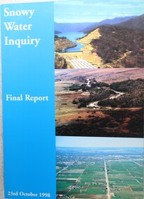
The Snowy Water Inquiry was commissioned in 1998 with a brief to recommend environmental water release options to the Commonwealth, Victorian, and NSW Governments so that corporatisation of the Snowy Mountains Scheme could proceed. This book contains the findings of the Inquiry into water allocation and uses of the Snowy River.A book of 160 pp - Snowy River Inquiry Final report 23rd October 1998. Submitted to the Governments of New South Wales and Victoria / Commissioner: The Hon. Robert Webster. On the front cover are three aerial photographs of the Snowy River and Snowy Hydro Scheme. The book contains maps and photographs.non-fictionThe Snowy Water Inquiry was commissioned in 1998 with a brief to recommend environmental water release options to the Commonwealth, Victorian, and NSW Governments so that corporatisation of the Snowy Mountains Scheme could proceed. This book contains the findings of the Inquiry into water allocation and uses of the Snowy River.snowy river hydro, snowy river government inquiry, water allocations, water resources developmen -
 Bacchus Marsh & District Historical Society
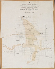
Map, Bacchus Marsh District (A). Proposed Irrigation and Water Supply Trust. Plan shewing boundaries of Trust District
The 1886 Irrigation Act in Victoria introduced the first legislation in Australia designed to enable the creation of a detailed scheme for agricultural irrigation. Part of the legislation saw the use of government funds for local irrigation projects. These local projects were managed by local irrigation trusts. The Bacchus Marsh Irrigation and Water Supply Trust was formed in 1889. This map depicts the proposed area of the Trust.Printed paper map of the proposed Bacchus Marsh Irrigation and Water Supply district. Circa 1889. Plan showing boundaries of Trust District. The District lies within the Parishes of Korkuperrimul, Merrimu, Parwan and Gorrockburkchap in the Counties of Bourke and Grant. At the top of the map above its title is the letter 'A; in capital lettering. Scale: 40 Chains = 1 inch.irrigation, water supply, bacchus marsh irrigation and water supply trust -
 Eltham District Historical Society Inc
Photograph - Colour Print, Alan Marshall's bungalow, 13 Park West Road, Eltham, 22 July 1993
From 1955 Alan Marshall's home was a bungalow at the rear of his sister's house at Eltham. The first bungalow burnt down. Its replacement shown here still stands. In March 2020 the property was sold. It was last sold previously in November 1982. No mention was made in the advertising regarding the heritage protected bungalow in the rear yard and advertising material presented it as having future potential to develop STCA (Subject To Council Approval). Concerned local members of the community alerted to EDHS to the pending upcoming sale and Council was also alerted to the sale and the potential risk presented to the heritage protected bungalow. In 2021 an updated amendment, C133nill, was made to the Nillumbik Planning Scheme in response to a planning application to develop the property following its sale. The Minster of Planning approved and gazetted the Amendment. Gazettal occurred on 25th November 2021. A copy of the gazetted Amendment is available on website of the Department of Environment, Land, Water and Planning at www.planning.vic.gov.au/schemes-and-amendments/browse-amendments. It was last updated March 2022.Colour photo print 10 x 15 cm, originally stuck down on corflute for displayeltham, alan marshall, alan marshall bungalow, heritage assessment, heritage protection overlay, houses, nillumbik shire council, park west road, heritage overlay ho147 -
 Eltham District Historical Society Inc
Photograph - Digital Photograph, Alan King, Pigeon Bank, Kangaroo Ground-Warrandyte Road, Kangaroo Ground, 6 February 2008
In 1848, Francis Rogerson form Dumfriesshire, Scotland purchased 80 acres of land at Kangaroo Ground on which he built a two-roomed bark hut. He named the property afterr the many Bronzewings and Wonga Pigeons in the area. Ewen Hugh Cameron moved to Pigeon Bank the same year he was elected to Parliament as the Member for Evelyn. At the time he moved in, Pigeon Bank had six rooms and the present water well. He made further extensive additions and lived there until his death in 1915. Covered under Heritage Overlay, Nillumbik Planning Scheme. Published: Nillumbik Now and Then / Marguerite Marshall 2008; photographs Alan King with Marguerite Marshall.; p27 Pigeon Bank, on the Kangaroo Ground – Warrandyte Road, Kangaroo Ground, is one of the Shire’s oldest farm dwellings, and has been home to some of the district’s earliest and most distinguished families. Although close to the road, the white weatherboard Victorian farmhouse is ensured privacy by the trees and hedges around it. On 4.8 hectares of farmland, Pigeon Bank is surrounded by rolling hills, farmland and bush, the peace of which is punctuated by an occasional birdcall. Pigeon Bank’s first owner was Francis Rogerson, from Dumfriesshire, Scotland, who bought 80 acres (32.4ha) of land in 1848 on which he built a two-roomed bark hut. Today this is the centre piece of the 14-room home.1 Rogerson lined the rooms with tongue-and-groove boards and roofed them with wooden shingles and sapling frames, which remain under the present green corrugated iron roof. He named Pigeon Bank after the many forest bronzewing and Wonga Pigeons in the area at the time, and the name Bank was commonly used in Scotland. Rogerson was united with one of the oldest families in the area when his sister Janet married John Bell, son of William, the original Bell settler. When Ewen Cameron moved to Pigeon Bank in 1874 it had six rooms and the present water well. He made extensive additions to the house and farm buildings and lived at Pigeon Bank until his death in 1915. Cameron, who had arrived in Melbourne from Scotland in 1853, contributed an enormous amount to the community. He worked as a builder, as a miner at Andersons Creek, a storekeeper at Queenstown2 and as the first postmaster at Warrandyte. In 1867 he married Agnes Bell, daughter of local farmer, John Bell. Cameron was a member of the Eltham Road Board (which preceded the Shire Council) and for more than 50 years, from 1863, he was an Eltham Shire Councillor, being President three times. Cameron was the Member for Evelyn for 40 years from 1874. In the 1880s he became the Government Whip, in 1902 the Minister for Mines and Water Supply, and in 1904, the Minister for Health, Cameron was also an outstanding farmer, whose farm won the Agricultural Department prize for the finest in the district, three consecutive times. Not surprisingly Pigeon Bank became the centre of district life. Every New Year’s Eve, Cameron hired a highland piper, who marched from the Kangaroo Ground school house to Pigeon Bank playing his pipes.3 Distinguished visitors included opera singer, Dame Nellie Melba, Victorian Premier, Thomas Bent, Governor, Lord Hopetoun and artist, Longstaff. Following Cameron’s death, the property changed hands several times, then returned to the family in 1919 when bought by Gordon Cameron. As the car took over from the horse, Pigeon Bank entered difficult times because the farm had produced chaff and oats and bred Clydesdales and harness ponies. In 1926 Mr Matthews bought the property and made many alterations including pulling down the kitchen, which had been separate from the main house. The property again changed hands several times. One owner was Senator James F Guthrie, who added a sunroom. In 1968 the house again returned to the Cameron family, when Vera Jackson, a grand-daughter of Ewen Cameron, and her husband, bought the property. The Bishop family, who were sixth and seventh generation Bells and also descended from the Camerons, restored the house in the 1980s. Today tongue-and-groove boards still line part of the hall (which retains two fine arches), the breakfast room, and Ewen Cameron’s former room. Five original fireplaces in the bed and living rooms are still in working order. The wide veranda with a curved iron roof and ornate iron lace work bounds three sides of the house, and nearby a windmill stands beside the water well. Sue and Ron James, who bought the property in 2001, made extensive improvements to the homestead and meticulously restored the grounds to their original state.This collection of almost 130 photos about places and people within the Shire of Nillumbik, an urban and rural municipality in Melbourne's north, contributes to an understanding of the history of the Shire. Published in 2008 immediately prior to the Black Saturday bushfires of February 7, 2009, it documents sites that were impacted, and in some cases destroyed by the fires. It includes photographs taken especially for the publication, creating a unique time capsule representing the Shire in the early 21st century. It remains the most recent comprehenesive publication devoted to the Shire's history connecting local residents to the past. nillumbik now and then (marshall-king) collection, ewen hugh cameron, francis rogerson, kangaroo ground, kangaroo ground-warrandyte road, pigeon bank -
 Eltham District Historical Society Inc
Photograph - Digital Photograph, Alan King, Maroondah Aqueduct Siphon Bridge over the Plenty River, 26 January 2008
Opened in 1891, the bridge formed part of the Maroondah Aqueduct carrying water from Watts River near Healesville to the reservoir at Preston where it joined Melbourne's metropolitan water system. Covered under Heritage Overlay, Nillumbik Planning Scheme. Published: Nillumbik Now and Then / Marguerite Marshall 2008; photographs Alan King with Marguerite Marshall.; p99 Built to supply thirsty Melbourne in the late 19th century, the siphon bridge spanning the Plenty River off Leischa Court, Greensborough, was part of an engineering masterpiece. Opened in 1891, the bridge formed part of the Maroondah Aqueduct carrying water from the Watts River near Healesville to the reservoir at Preston where it joined the metropolitan distribution system. A major link in Melbourne’s water supply, it also had a huge impact on communities, which mushroomed along its route. Named after the Aboriginal word for the area around the Maroondah Reservoir, the Maroondah Aqueduct was fully operational until the 1970s. Since the 1980s the land along parts of the aqueduct have been used for walking and bicycle riding, shaded in places by Monterey Pine trees planted to stabilise the surrounding ground. From 1857 the Yan Yean Reservoir supplied Melbourne’s water but the growing city needed additional catchments.1 In 1886 work began on a weir on the Watts River to enable the aqueduct to carry most of the river water 41 miles (66km) to Melbourne. The aqueduct, built by the Board of Works, is the oldest remaining aqueduct near Melbourne and was probably the first built with concrete.2 Although the aqueduct is now only used between the Maroondah and Sugarloaf Reservoirs, it can still be traced across the Shire. It extends from the Maroondah Reservoir through Christmas Hills, Kangaroo Ground, Research, Eltham, St Helena and then previously wound west through Greensborough to Reservoir.3 Built by horse and manpower the aqueduct gravity fed 25 million gallons (113.6ML) of water a day to Melbourne along a gradient of one foot to the mile. It included 25 miles (41km) of open concrete and brick channel, six miles (10km) of tunnels, and nine miles (15km) of 14 inverted siphons of riveted wrought-iron across creeks. Bricks for the aqueduct were made from clay found near the sites and remains of several kilns can still be found between Kangaroo Ground and Christmas Hills. Building the aqueduct transformed local communities. An abattoir was established at Christmas Hills. Grog shanties and labourers’ camps sprang up and local courts dealt with cases of ‘petty pilfering and boisterous behaviour’.4 The Kangaroo Ground school population jumped to 91, crammed into a room with one teacher. Miners who built the tunnels camped just north of Churinga in Greensborough – then called Tunnel Hill Camp – and adjacent to the Evelyn Arms Hotel. The miners’ high spirits were sometimes quenched in horse troughs or by a ‘welt under the ear and kick on the behind’ as the local constable calmed them down rather than lock them up.5 But the growing city of Melbourne needed more water, so the O’Shannassy catchment, east of Warburton, was added to the system in 1914. In 1920 work began on the present concrete Maroondah Dam one mile (1.6km) from the weir on the Watts River. The aqueduct capacity was thus doubled to 50 million gallons (227ML) a day.6 Intense land development threatened to pollute the open water supply, so channel sections were replaced with large pipes. In the late 1960s a large water main was built from the tunnel outlet at Research and extended through St Helena and Greensborough, so this section of the aqueduct was taken out of use. Long sections of the unused open channels in Greensborough and Bundoora were destroyed, but the old channel in Research and Eltham North remained largely intact. In the 1970s, the Sugarloaf Reservoir was constructed, inundating 445 hectares of land in Christmas Hills. Sugarloaf was officially opened in 1980 and serves as a water storage and treatment plant supplying Melbourne. In the early 1980s pipes replaced the section from Sugarloaf Reservoir to the tunnel entrance at Kangaroo Ground. The Research-Kangaroo Ground tunnel operates as part of the pipeline system.This collection of almost 130 photos about places and people within the Shire of Nillumbik, an urban and rural municipality in Melbourne's north, contributes to an understanding of the history of the Shire. Published in 2008 immediately prior to the Black Saturday bushfires of February 7, 2009, it documents sites that were impacted, and in some cases destroyed by the fires. It includes photographs taken especially for the publication, creating a unique time capsule representing the Shire in the early 21st century. It remains the most recent comprehenesive publication devoted to the Shire's history connecting local residents to the past. nillumbik now and then (marshall-king) collection, maroondah aqueduct, pipe bridge, siphon bridge -
 Eltham District Historical Society Inc
Photograph - Digital Photograph, Marguerite Marshall, Smith Dam, Karingal Drive, Eltham, 19 September 2006
The dam at the entrance to the Nerreman Gateway in Eltham was built according to an internationally acclaimed theory developed by the builder's father. In 1920, Victorian engineer B.A. Smith was awarded the American Society of Civil Engineers J. James R. Cross Gold Medal for his Technical Paper titled 'Arched Dams'. It was the first time this medal had been awarded outside the United States. The concrete arched dam across the Eltham West Drain was built in 1940 by B.A. Smith's son and engineer, D. B. (Bernie) Smith to water the 24 acre (9.75 ha) hobby farm owned by himself and new wife, Isa Smith. Upon completion of the dam a pump-house was constructed beside the creek but before the water could be pumped up the hill they had to dig a trench and lay 500m of 100mm water main to an elevated holding tank. The Smiths made the pump-house their home for several years until they constructed their home at the top of the hill overlooking Eltham and views extending to Kinglake. Following Bernie's death in 1983, Nerreman Park was subdivided between 1993 and 1995. Gordon Ford designed the landscaping and the pump-house was demolished. Covered under Heritage Overlay, Nillumbik Planning Scheme. Published: Nillumbik Now and Then / Marguerite Marshall 2008; photographs Alan King with Marguerite Marshall.; p137 The dam at the entrance to the Nerreman Gateway in Eltham, was built according to an internationally acclaimed theory developed by the builder’s father. In 1920, Victorian engineer B A Smith was awarded the American Society of Civil Engineers J. James R. Croes Gold Medal, for his Technical Paper titled Arched Dams. It was the first time this medal had been awarded outside America. An international example of the application of Smith’s work can be found in the design of the Hoover Dam on the Colorado River, Nevada, USA. Built between 1930 and 1936, it is recognised by the ASCE as one of ‘America’s Seven Modern Civil Engineering Wonders’.1 The concrete arched dam across the Eltham West Drain was built by B A Smith’s son and engineer, D B (Bernie) Smith. Bernie’s dam followed his father’s theory, having a curvature that takes maximum advantage of concrete’s great strength in compression. The water load is carried into the abutments because of this curvature, which permits a wall thickness of only 225 millimetres thick at its crest, despite the dam’s capacity of more than 4.5 megalitres. The Eltham dam was designed to water the 24 acre (9.75 ha) hobby farm belonging to newly married couple Bernie and Isa Smith. Bernie, from Armadale, and Isa, from a farm at Tyntynder near Swan Hill, were attracted to the hilly topography and the creek running through the property. It extended from Ryans Road, Eltham, to Karingal Drive, Montmorency and was adjacent to Meruka Park. The Smiths named it Nerreman Park using the Aboriginal word Nerreman meaning ‘River Bend’ as their creek had a pronounced bend.2 In 1940 the first thing Bernie did was to build a dam, and with Isa’s help, a pump-house, to secure a water supply for their cattle, pigs, chickens, orchard and vegetable gardens. It was also available for the fire-plugs, which they placed all over the property in case of bushfire. The couple built the pump-house beside the creek and installed a Tange three-plunger pump, which had originally supplied the City of Wodonga with water. But before the Smiths could pump water up the hill from the dam they had to dig a trench and lay about 550 yards (500m) of a four-inch (100mm) water main up to an elevated holding tank. The trench was dug with a single furrow plough drawn by an old draught horse. Living in rough conditions did not deter the Smiths, who made the pump-house their home, where they still lived when their first child was born in 1944. They later built their home at the top of their property overlooking Eltham, with magnificent views to Kinglake, the Dandenong Ranges and Melbourne. From 1946 it took them almost 20 years to complete the 36-square house with its 12-foot (3.6m) high ceilings. Material for the concrete roof and walls faced with sandstone, was ripped out of the ground on their property by plough pulled by tandem Clydesdale horses. Isa was a strong woman – two days before their second child was born – she set three huge sandstone boulders in place in the bottom wall of the garage. She also mixed all the cement for the house. A collapsed kitchen wall did not discourage her from rebuilding it in a week, while her husband was away working in the country. She later recalled: ‘We stood back to admire this beautiful wall we’d built and while we were looking at it, it came tumbling down’.3 Following Bernie’s death in 1983, Nerreman Park was subdivided, between 1993 and 1995. Local Gordon Ford designed the landscaping and the pump-house was pulled down. But the dam remains as a reminder of exceptional engineering4 – and of a remarkable couple.This collection of almost 130 photos about places and people within the Shire of Nillumbik, an urban and rural municipality in Melbourne's north, contributes to an understanding of the history of the Shire. Published in 2008 immediately prior to the Black Saturday bushfires of February 7, 2009, it documents sites that were impacted, and in some cases destroyed by the fires. It includes photographs taken especially for the publication, creating a unique time capsule representing the Shire in the early 21st century. It remains the most recent comprehenesive publication devoted to the Shire's history connecting local residents to the past. nillumbik now and then (marshall-king) collection, eltham, karingal drive, smiths dam, bernie smith, gordon ford, isa smith, nerreman gateway, nerreman park estate, dams -
 Bendigo Historical Society Inc.
Newspaper - JENNY FOLEY COLLECTION: FLOWING
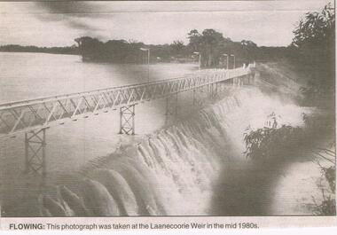
The Laanecoorie Weir on the Loddon River supplies both irrigation and domestic water. It was the second Victorian irrigation scheme after the Goulbourn. It was constructed 1889-1892 with the outlet valves installed in 1891.Bendigo Advertiser ''The way we were'' from 2003. Flowing: this photograph was taken at the Laanecoorie Weir in the mid 1980s. The clip is in a folder.newspaper, bendigo advertiser, the way we were -
 Forests Commission Retired Personnel Association (FCRPA)
Beechworth FCV District office sign
This sign proudly hung outside the Forests Commission Victoria (FCV) Beechworth office which is now site of the Forestry Heritage Museum. The granite building in the Beechworth's historic precinct was once the Gold Warden's Office and is one of the town's original buildings. The FCV was the main government authority responsible for management and protection of State forests in Victoria between 1918 and 1983. The Commission was responsible for ″forest policy, prevention and suppression of bushfires, issuing leases and licences, planting and thinning of forests, the development of plantations, reforestation, nurseries, forestry education, the development of commercial timber harvesting and marketing of produce, building and maintaining forest roads, provision of recreation facilities, protection of water, soils and wildlife, forest research and making recommendations on the acquisition or alienation of land for forest purposes″. The Forests Commission had a long and proud history of innovation and of managing Victoria's State forests but in September 1983 lost its discrete identity when it was merged into the newly formed Victorian Department of Conservation, Forests and Lands (CFL) along with the Crown Lands and Survey Department, National Park Service, Soil Conservation Authority and Fisheries and Wildlife Service. After the amalgamation the management of State forests and the forestry profession continued but the tempo of change accelerated, with many more departmental restructures occurring over the subsequent four decades. Responsibilities are currently split between the Department of Energy, Environment and Climate Action (DEECA), Forests Fire Management Victoria (FFMV), Parks Victoria, Melbourne Water, Alpine Resorts Commission, the State Government-owned commercial entity VicForests and the privately owned Hancock Victorian Plantations (HVP).Large office sign. Hand painted in traditional FCV mission brown and gold colour scheme.forests commission victoria (fcv), forest signs -
 Bendigo Historical Society Inc.
Document - DRAINAGE PROBLEMS - INRUSH OF WATER AT THE VICTORIA QUARTZ
Two handwritten copies of a Bendigo Advertiser report 16/6/1910 Page 7. This is a longer version of 3600.14. It was thought that the rush of water was from a dam bursting in one of the other mines, but as the water showed no signs of slowing that theory was discarded. The temperature of the incoming water was much higher than the Victoria Quartz was accustomed to bail, and this circumstance is significent in view of the increased temperature of the water at the deep levels in the New Chum Railway. Some months ago, the water commenced to flow from the New Chum Railway workings into the New Shenandoah, which is the next mine north. The water rose so rapidly that a disaster was narrowly averted. The mines along the line were connected at different levels and with the cessation of bailing at the deep levels in the southern mines, it was only to be expected that the water would find its way north to the Victoria Quartz. The water raised from the operating mines under the direction of the New Chum Drainage Association, a yeart or two ago used to exceed six million gallons per month. At that time there were eight companies bailing water, and even then some of the plants, especially those at the deep mines, were severely taxed in coping with the water, and performing ordinary work. Since some mines had discontinued bailing, the water has been filling up extensive workings, and as was predicted in the ''Advertiser'' some time ago, the Victoria Quartz Company could not expect to succeed with its deep sinking project without making some special provision for raising the water, which ultimately would become a source of trouble. The Victoria Quartz Company was allotted a special grant of 10,000 pound to assist in sinking the shaft 1000 ft from the 4254 ft level. Under the conditions of the grant, the Company had to contribute half the cost of the sinking, and the raising of the water has also been an exensive item. For the present, all attention will be concentrated in lowering the water, and should the appliances prove unequal to the task the deep sinking scheme can only be accomplished by resorting to some comprehensive system of combating the water'. Document from Albert Richardson Collection of mining history.document, gold, drainage problems, drainage problems, inrush of water at the victoria quartz, bendigo advertiser 16/6/1910 page 7, mine reports 13/6/1910, victoria quartz, lansell's 180, mr stevens, mr w abraham, new chum & victoria mine, new chum railway, new shenandoah, new chum drainage association -
 Bendigo Historical Society Inc.
Document - DRAINAGE PROBLEMS - NEW CHUM DRAINAGE PROPOSALS
Six pages of handwritten notes regarding the New Chum Drainage Proposals. Extracts from the Bendigo Advertiser mentioning the rising of the water in the New Chum Mines. An Advertiser report 27/12/1910 mentions that deep mining will have to be abandoned owing to the absence of some proper scheme to cope with the water. An arrangement had been made by which the companies affected along the line should contribute to a scheme. Suggestions made that the water be lifted by electric pumps. Baling with tanks had been tried for 6 months and then abandoned. Directors Report Victoria Reef Quartz Jan 1911 mentions unwatering had been carried on with assistance of Government. On the 20th Dec, one rope gave out. Decided that replacing it and doing the necessary work could not be met in the present financial conditions. It was also considered that the costof trying to reach the bottom reefcut in the New Chum Railway could not be continued by baling as its cost proved too expensive, while it could probably be done economically & effectively by electric pump which is now subject to negotiations with the Mining Dept.' At the end of the report is a Balance Sheet. Document from Albert Richardson Collection of mining history.document, gold, drainage problems, drainage problems, new chum drainage proposals, bendigo advertiser 11/1/1911 page 7, victoria quartz, victoria consols, bendigo advertiser 5/7/1910 page 3, mr h v whitelaw, mines dept, insp ross, lansell's 180, 222, new chum consolidated, lazarus, bendigo advertiser 6/7/1910 page 7, 9/7/1910 page 9, drainage troubles, bendigo advertiser 8/7/ page 8, new chum railway, south belle vue, eureka ext'd, bgo adv 25/7 1910, 27/12/1910 page 2, rae's machine, bendigo advertiser 2/1/1911, mr mcbride, mines dept, mr stanfield, mines act, bendigo advertiser 16/1/1911 page 3, victoria reef quartz half yearly meeting 1911, directors report and balance sheet, geo paynting -
 Bendigo Historical Society Inc.
Document - DRAINAGE PROBLEMS - VICTORIA QUARTZ INFLUX OF WATER
Handwritten copy of a report in the Bendigo Advertiser 12/7/1910 Page 2. New Chum Mines. Progress of Bailing Operations. The bailing operations at the New Chum mines have not yet had the desired effect of lowering the water. On the contrary the water continues to rise in the Victoria Quartz which is the mine most directly affected. It is expected that the necessary preparations at the Lazarus will be completed today when it is hoped that bailing will be commenced at that mine. The success of the bailing scheme will largely depend on the efforts of the Lazarus to cope with the water and the progress made during the next few days will be awaited with interest. It is generally believed that the great volume of water is coming north from the southern group of mines. The companies south of the New Chum Consolidated are not bailing, and the pumping service at the New Chum Railway which is installed down to the 550 ft. level has not been operated since that company abandoned work a few months ago. A perusal of the statistics of the New Chum Drainage Association shows that the pumps at the New Chum Railway were lifting on anaverage close on 1,000,000 galls of water per month in the winter. That great volume of water is now pouring from storage dams at 550 feet to the deep levels, and in the natural order of things will have to be lifted by the tanking system in vogue at the mines N.' Document from Albert Richardson Collection of mining history.document, gold, drainage problems, new chum drainage association, victoria quartz influx of water, bendigo advertiser 12/7/1910 page 2, victoria quartz, lazarus, new chum consolidated, new chum railway, new chum drainage association -
 Bendigo Historical Society Inc.
Document - DRAINAGE PROBLEMS - NEW CHUM LINE DRAINAGE PROBLEMS 1910
Handwritten extract from the Bendigo Advertiser 27/12/1910 Page 2. ''The Victoria Quartz, having deepened its shaft to 4,614 feet, had to abandon sinking on account of an inrush of water from the flooded mines to the south on the line. The influx occurred on the 15th of June, and notwithstanding that baling has been carried on almost constantly the company has failed to get the water out. It appears that the deep ground will have to be abandoned, owing to the absence of some proper scheme to cope with the water.'' Albert Richardson Mining History Collection.document, gold, drainage problems, drainage problems, new chum line drainage problems 1910, bendigo advertiser 27/12/1910 page 2, victoria quartz, albert richardson -
 Bendigo Historical Society Inc.
Document - DRAINAGE PROBLEMS - NEW CHUM DRAINAGE SCHEME
Handwritten notes from the Bendigo Advertiser 6/12/1901 detailing the amount of water the Companies had bailed for the past month. Document from Albert Richardson Collection of mining history.gold, drainage problems, new chum drainage association, new chum drainage scheme, bendigo advertiser 6/12/1901 under 'mining intelligence', eureka extended, new chum railway, shenandoah, shamrock, young chum, garibaldi, lazarus, old chum, new chum & victoria, lansell's 180, albert richardson -
 Kiewa Valley Historical Society
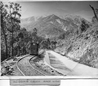
Photo - Bogong Creek Race Line
The SECV constructed the Kiewa Hydro Electric Scheme which included race lines to catch the water and feed it into the dams that they built to create hydro electric power. The rail line was used to construct the race line and enables the race line to be easily checked for maintenance eg. fallen trees The SECV constructed the Kiewa Hydro Electric Scheme from the late 1940s to 1961 being one of the first hydro schemes and hence environmently friendly.Shiny black and white photo showing the railway track, with a locomotive on it, beside the race line. Snow is on the surrounding mountains. ;Bogong Creek Race Line in pen and attafhed to the photo. On the back "Property of / State Electricity Commission of Victoria/ Publicity photo / Permission to Publish must be obtained / and acknowledgement made. / Negative No. 14-138bogong creek race line, kiewa hydro electric scheme -
 University of Melbourne, Burnley Campus Archives
Plan, Water Garden & Grassy woodland, 1987-1995
(1) Water Garden V.C.A.H Burnley Irrigation Plan, drawn by M.D. 12.11.87. (2) Tracing paper copy, Proposed Pool Development Native Garden V.C.A.H. Burnley -Survey of approximate dimensions showing fall and depth of pools. Drawn by J.H.K. 9.9.88. (3) Rough coloured plan, Water Garden Planting Plan. (4) Proposed Water Garden V.C.A.H. Burnley by Robert W. Boyle and Associates October 1988, with handwritten annotations by James Hitchmough. (5) Coloured final version. (6) Tracing paper copy, Planting Scheme Native Garden VCAH Burnley. Design by James Hitchmough. Drawing J.K. 13.8.90. (7) Section Native Grassland Burnley Campus - Larger Tree Cover by Marika Kocsis & Martin Hopkins. Drawn by Leigh Stone 25.9.95. Survey Plan, no key to numbers. (8) Section Native Grassland by Marika Kocsis & Martin Hopkins. Drawn by Leigh Stone 20.9.95. No key to numbers. (9) Tracing paper copy Native Garden by Paul Eaves 6.9.90. Scale 1:100. Also 2 plant lists (11.0478/1 and /2). Also see 11.0478 List of plants. (11) Letter to P. Tulk from Robert Boyle dated 07.10.1988 "Re: Cost Estimates for Construction of Proposed Water Garden."water garden, vcah, robert w. boyle, james hitchmough, jill kellow, marika kocsis, martin hopkins, leigh stone, paul eaves -
 Bendigo Historical Society Inc.
Document - RAE'S CRUSHING BATTERY - THE RICH VICTORIA HILL
Eleven pages including four pages of photocopied photos, They are:- Wm Rae's Crushing Works, The Victoria Quartz Mine, Looking North from Old Chum Hill to the Victoria Hill early 1870's, Victoria Hill from Rae's Open Cut. Notes begin at page 4, there are two page 6 and no page 7, otherwise same notes as 3573.1. Small note with 'Notes on Victoria Hill - incomplete. Notes prepared by Albert Richardson.document, gold, rae's crushing battery, rae's crushing battery, wm rae's crushing works, victoria quartz mine, view from old chum hill to the victoria hill, victoria hill from rae's open cut, ballerstedt, lansell's bit 180, dickers mining record 23/11/1861, j n macartney bendigo goldfields registry 1871, new chum syncline, cleopatra needle type chimney, victoria quartz coy, annals of bendigo, australian mining standard special edition 1/6/1899, bendigo advertiser, bendigo & vicinity 1895, h harkness & sons, new chum drainage scheme, eureka extd, new chum railway, pearl, inrush of water at victoria quartz mine, floyd's small 5 head crushing battery, great central victoria (midway), midway, midway no 2, midway north, ballerstedt's small 24 yard claim, the humboldt, wittscheibe, the adventure, bendigo mines ltd, luffsman & sterry's claim, round shaft, chinese joss house, fortuna -
 Bendigo Historical Society Inc.
Document - VICTORIA HILL - NOTES ON VICTORIA HILL (SIGNS)
Twelve handwritten copied pages (a & b) of notes with typed copy of same, regarding the signs for Victoria Hill. Signs indicate the feature and a description including Prospecting Shafts, dams, engine beds, Lansell's Big 180 Shaft, stampers, Victoria Quartz Mine, Victoria Quartz Dams, Rae's Open Cut, Anticlinal Arch, small primitive tunnels, Engine-bed for Great Central Victoria known as 'Midway' mine, prospecting tunnels, floyd's small 5 Head Crushing Battery, Ballerstedt's Small 24 Yard Claim, The Humboldt 1856 to 1861, Luffsman and Sterry's Claim, and A Round Shaft.document, memo, victoria hill, victoria hill, notes on victoria hill (signs), lansell's big 180, ballerstedt senior, george lansell, victoria quartz mine, victoria reef quartz coy, wm rae, a roberts & sons, mr e j dunn, new chum drainage scheme, eureka extended, new chum railway, pearl, bendigo advertiser, inrush of water at the victoria quartz, victoria consols, shamrock, shenandoah, victoria quartz dams, rae's open cut. prospecting tunnel, floyd's small 5 head crushing battery, great central victoria (midway), midway no 2, midway north, ballerstedt's small 24 yard claim, the humboldt, wittscheibe, the adventure, advance, george lansell, luffsman & sterry's claim, david sterry, gold mines hotel, city of sandhurst, lansell's fortuna, a richardson -
 Stawell Historical Society Inc
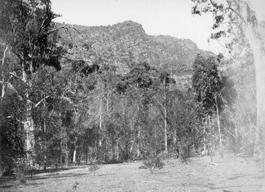
Photograph, Grampians at Halls Gap 1866
Grampians Halls Gap. Part of a collection of Photographs by Mr. O.G. Armstrong as commissioned by the Shire of Stawell for the Inter-colonial and Paris Exhibition in Melbourne in 1866. From about 1860 there was agitation for a water supply, not only for Stawell but for the Wimmer Mallee as well. In 1887 Wartook was adopted as the first reservoir for the Wimmer. Stawells water supply was designed by Mr. John D’Alton. The scheme came from Fyan’s Creek via Wooden Fluming and a Syphon and finally through the mountain in a tunnel, before being piped to a reservoir on Big Hill. The system was completed in December 1881 and although there have been modifications, basically it has not been changed to this day. The Wimmera Mallee stock and domestic system from the Grampians is the largest system of its kind in the world, the latest edition being like Belfield and piping of Wimmera channels. stawell -
 Bendigo Historical Society Inc.
Document - Michele Matthews collection - paperwork and reports for re-zoning of Maiden Gully (1993 - 1996). Residents opposed the re-zoning as they had purchased land as "bush blocks", 25/02/2025
... sewerage scheme 27/03/1995 - Coliban Water letter to WR & MS... sewerage scheme 27/03/1995 - Coliban Water letter to WR & MS ...documents for Maiden Gully Sewerage SchemeMichele Matthews collection - paperwork and reports for re-zoning of Maiden Gully (1993 - 1996). Residents opposed the re-zoning as they had purchased land as "bush blocks" Coliban water Annual report 1993/94 21/12/1994 Maiden Gully Development Committee - newsletter No 1 - cttee met with representatives of Coliban Water Caliban Water information Bulletin January 1995 - Maiden Gully Sewerage Scheme 22/02/1995 Maiden Gully Development Committee - newsletter No 2 - cttee activities re the planned sewerage scheme 27/03/1995 - Coliban Water letter to WR & MS Matthews, owners 3 Clay Gully Court (Lot 56 LP 212245) undated - Maiden Gully Neighborhood Sewerage Schemes - Robin Hill Estate Scheme (cost allocation to property owners 21/04/1995 five-page letter of objection/complaint from WR & MS Matthews, owners 3 Clay Gully Court, re costs allocated against their property (Lot 56 LP 212245) 16/06/1995 five-page response from Coliban Water to WR & MS Matthews, owners 3 Clay Gully Court; regarding the outcome of their objection to the sewerage scheme 22/08/1995 letter from WR & MS Matthews, to resident re the results of their objections (and consequent concessions) from Coliban Water re the Robin Hill Estate Sept 1995 Maiden Gully Structure Plan, prepared by TEA planners & Planning Australia Consultants; provides a structure plan, for the Rural City of Marong, the propose future development of the Maiden Gully area Greater Bendigo Planning Scheme - Amendment L43 - Maiden Gully Township: * undated and author unstated - Maiden Gully questions sheet for residents re the proposed Maiden Gully Structure Plan - seven questions and answers * Fauna species - observed /recorded site 6; Maiden Gully (off Pioneer drive) * Explanatory report, three pages * 1/11/1995 Notice of Amendment to a Planning Scheme * Greater Bendigo Planning Scheme, Chapter 6, Amendment L43 (five pages) December 1995 Coliban Water "In the Pipe line", Maiden Gully Region Community Newsletter No 2 - Halfway mark for Sewerage Scheme March 1996 Coliban Water "In the Pipe line", Maiden Gully Region Community Newsletter No 3 - Home stretch for new sewer scheme May 1996 Coliban Water "In the Pipe line", Maiden Gully Region Community Newsletter No 4 - New sewerage scheme comes in well under budget Undated - Maiden Gully Township - Amendment L43 - Panel Hearing report (31 pages) maiden gully, sewerage scheme -
 Lakes Entrance Historical Society
Book, The Department of Industry Science and Resources, Analysis of Snowy Mountain Hydro Scheme, 2000
Analysis of the complexity of water flow issues, electricity market implications and broader social economic and environmental considerations associated with the operation of the Snowy Mountains SchemeISBN 06427211440environment, water supply, waterways -
 Ringwood and District Historical Society
Photograph, Boiler explosion at Ringwood station 20th June 1894 for engine 297R. "Heard in Box Hill"
Black and white photographs - 2 copiesTyped below photograph, "Boiler explosion at Ringwood station 20/6/1894. Heard in Box Hill". Article from newspapers:- Weekly Times (Melbourne, Vic. : 1869 - 1954), Saturday 27 January 1894, page 21 Official enquiry. The Board of Enquiry appointed by the Railway Commissioners to enquire into the causes of the boiler explosion which shattered the locomotive at Ringwood on Saturday night, assembled at the Railway department on Wednesday to commence its deliberations, The board consisted of Mr R. Fulton, engineer, C. W. McLean; engineer to the Marine Board, and Mr Mephan Ferguson, iron-founder. There is some difficulty at the outset about the constitution of the board; It was suggested that the Apt of Parliament contemplated that boards of experts, after the manner of the present one, needed, to have their appointments confirmed by the Governor-in-Council. The point, however, was not considered sufficiently important to prevent the board from proceeding with evidence. Robert Greyford, stationmaster at Ringwood, was the first witness. He said he saw the explosion on Saturday night at about twenty minutes to 8. There was a rush to the engine to see what had happened, and the driver and fireman were both found on the platform of the engine. The driver seemed badly hurt, but the fireman, to all appearances, was not so badly injured. They were both attended to and sent up to Melbourne by the last suburban train. Witness had a look at the engine and found the dome and all the plates round the boiler blown clean, away. The springs were also blown clean away. The Chairman (Mr Fulton) : Did you measure the distance ? Witness: Yes; one of the plates was 209 yards away. A piece from the top of the boiler 15 pounds in weight he found driven into the hard beaten track 410 yards away. Several pieces of boiler plate were found scattered at various distances. The buildings roundabout were injured. The Chairman; Did you notice anything peculiar about either of the driver or the fireman ? — No ; nothing wrong, with either of them. If the engine was blowing off at all, it must have been very light. In your opinion, were they perfectly sober ? — Perfectly. In approaching the station, is there a down or an up grade? — A very slight down grade. How is the road from Healesville ? — Up and down all the way. It is down, grade for about 200 yards coming into Ringwood station. They shut off ; steam about a quarter of a mile away, and come in at a good pace. They generally put on 15 pounds of steam while they are in the station. Mr Ferguson : Had the driver the usual load on ? — Yes ; about the usual load. Witness added that he had known the driver personally for about 10 years, and he had always been a careful, steady, sober man. He did not know the fireman so well. John Palmer, porter at Ringwood station, also saw the explosion. He was attending to the train on its arrival. He was knocked down by the force of the explosion. When he got up he saw the engine driver being carried into the office covered in blood. He noticed nothing peculiar about the driver and fireman, nor about the engine. Mr McLean : How far were you from the engine when you were knocked down ? — From ten to fifteen yards. William Paul, the guard of the train to which the injured locomotive Was attached, said he was looking at the engine at the very moment the explosion occurred. It seemed to come from exactly under the dome. The force of it took him off his feet. He was about 15 yards from the tender. When he rose he tried to reach the engine, but could not do so on account of the steam and coal dust. He called out to know whether any of the passengers were injured, and got no response, so that he concluded they were all right. All the lamps but about half dozen were extinguished by the force of the explosion, although the glass was not broken. He could testify most distinctly that the driver and fireman were both sober. The driver was a man who never drank. The steam started to blow off about a minute and a half before the explosion took place. The last place at which the engine took water was Healesville. The Chairman : Do yon know anything of the quality of the water there ? Is it creek water ? — Yes ; it comes from the Graceburn River. You never heard of its quality ?— No. How long have you known this engine on the road— About 13 months. Hew long have you known the driver on this line ? — About six weeks. I have known the fireman several years. The driver was a strict teetotaller, and I never saw the fireman take anything to drink in his life. Mr T. H, Woodroffe, chief mechanical engineer of the Victorian Railways, produced a report he had written to the secretary, about this explosion. The document gave facts concerning the engine and the explosion. It stated that the rapture seemed to have occurred at the rim of the plates adjoining the fire box. The engine was built at the Phoenix Foundry, Ballarat, in 1883. It was repaired at various times, the last time being in July of last year when it was sent to the Port Melbourne shops, and was then tested to a cold water pressure of 195 and found all right. It was the custom to overhaul all locomotives about every five years. The Chairman : There were no very heavy repairs in July, 1893; were there? — Not to the boilers. The shop manager's report says that the plug and safety tap holes were repaired, five new copper studs put in firebox, ash-pan door repaired, tender cleaned and overhauled, and studs re-rivetted, and boiler tested to pressure of 195, cold water. Mr Woodroffe read the report of the repairs effected to the boiler in December, 1888. That would be the time the plate was put in the boiler. On that occasion three new plates were put in the bottom and the boiler tested up to 195. The Chairman: Do you keep a record of the water used ?— Yes, the water in this case, I think, came from the Maroondah scheme. Mr Woodroffe said boilers were examined front time to time in the running sheds. In his opinion every possible care had been taken to keep the engine in proper care. There might, however, be lessons learnt from this. The Chairman: No doubt. From his examination of the plates [the] witness did not think the state of them could have been detected from the outside. There were no signs of leakage or sweating or anything of that sort. The next witness- was Walter Stinton, workshop manager at Newport and he said that the injured engine had been repeatedly repaired under his charge. He gave a technical account of the repairs effected on various occasions. The testing of locomotives was under his special notice. They had a high pressure pipe running; round the works, and a pump set at 2001b. When the boiler was pumped full of water the pressure when applied up to 1951b. The board appointed by the department to inquire into the Ringwood locomotive boiler explosion sat again at Spencer street on 25th inst. Mr R. Fulton presided and the other members of the board were. Mr Mephan Ferguson and Mr C. W. McLean. Charles Grubb, foreman of the boiler-makers at the Newport workshops, said he had inspected the pieces of plate that had been blown out of the engine, and after examining them, pointed out to the Chief Mechanical Engineer the portion where the plate had started to burst. It was under the lap, on the right hand side of the boiler. The grooving might be accounted for by bad water. During the past twenty years he had examined all the boilers that came into the Williamstown workshops, and while some were hardly marked at all, others were very badly eaten away. The practice was to cut out the defective portions. In this case the boiler was repaired in a similar manner. The Chairman : Can you suggest any other way of repairing so as to prevent accident ? — No, unless by taking out a plate on one side from the joint, and carrying it further up so as to avoid the joints meeting, or by taking out the plate altogether. What would.be the cost .of putting in a new " plate I—Perhaps about double the price; but I wouldn't recommend that course. It would be putting a new plate against plates that have been in use ten years or so and that would not be advisable. I think the present system better. I consider the present system of repairing the best. This is the first we have had so bad like that, to my knowledge. You attributed this to bad water. Is there no other probable cause ? — Well; unless the iron be bad. This was Lowmoor iron. I think this accident was caused by the eating away of plates. This one was the worst I have seen, for the short time it had been running. We use three classes of iron — Lowmoor, Monkbridge and Bowling. By Mr Woodroffe (Chief Mechanical Engineer) ; There are engines still running that were repaired at the same time as this one, in 1888, and. in the same way. These are engines 339 and 333. They have been recently examined and are in splendid order. What in your experience, is the age of a boiler on the Victorian railways? — From 17 to 20 years our earlier boilers stood. The later boilers don't stand so well. How is that? — There is difference in construction, and the material is lighter. The old boilers had thicker plates. Have you been asked in any way to curtail boiler affairs? — No, sir; nor in any way. You have never hesitated to carry out any necessary repairs? — Never. Our orders have been to exercise every care in examining, repairing and renewing boilers. Witness said that his practice was when an engine came into the workshop to find out how long she had been running. If over five years, he informed the workshop manager, and they thought it necessary the tubes were taken nut. If everything was in good order witness reported to the manager. The cost of taking out the tubes and putting them in again was about L20. Mr Woodroffe : Have you ever hesitated to repair a boiler on the score of expense ? — No, never. Mr McLean : Hew do yon ascertain whether a boiler requires repairs?— I keep a record of every boiler examined. From every boiler that comes in I have the dome covers taken off, and when it is practical I get inside. l can almost tell from the top of a boiler what the bottom is like. If there is any doubt about it I have the tubes taken out. If I have suspicion of defective plate I cause to have bored a triangle in the plate at the point where there is the most wear. There is a travelling inspector who visits all the running sheds of the colony except Port Melbourne and tests the boilers. He reports to us and we note what he points out. Alfred Thompson, locomotive inspector of the eastern section, said he knew this engine, 297R. He read a list of her repairs. He heard of the accident on Saturday night and went up to Ringwood. The Chairman : Did you ever notice anything peculiar about the engine? — No, I considered her A1 and would not have hesitated to have put on 140lb pressure owing to the repairs she had undergone. Witness considered that the explosion was caused by the expansion and contraction of the plates ; and, no doubt, the plate had been eaten away through bad water. The other side of the boiler showed: signs of corrosion: By Mr Woodroffe ; Is every care taken with the boilers ? — Yes, every possible care is taken for the safety of boilers, Weekly Times (Melbourne, Vic. : 1869 - 1954), Saturday 27 January 1894, page 7 EXPLOSION OF A LOCOMOTIVE BOILER, NARROW ESACPE FROM FATALITIES. THE DAMAGED ENGINE. [See drawing of loco – saved in “Railways” folder] The explosion of a locomotive boiler at Ringwood on Saturday evening, formed the subject of much discussion in railway circles on Monday. The Minister arrived at the office at an unusually early hour and immediately entered into a consultation with the acting chairman, Mr Kibble, and Mr Commissioner Murray. As the result of the interview it was resolved to ask three gentlemen of acknowledged engineering experience to sib as a board with the . object of inquiring into the cause of the accident and furnishing a report. Mr Richardson and the Commissioners are tally seized of the importance of having a searching investigation into the accident, and, with Mr Murray, the former went to Ringwood to inspect the scene of the disaster. They will he accompanied by Mr Woodroffe. During the morning no official report had come to hand from the driver or fireman of the engine in reference to the accident, but that is thought to be due to the circumstance that they have not sufficiently recovered to be able to give a circumstantial account of what occurred. The engine was one of the old R's, and, Mr Kibble pronounced them to be about the best class of engines used. So far nothing can be said as to the probable cause of the accident, as the broken plating of the engine has not been submitted to the inspection of experts. Weekly Times (Melbourne, Vic. : 1869 - 1954), Saturday 27 January 1894, page 7 STATEMENT BY THE FIREMAN. This morning Thomas Miles, fireman on the engine the boiler of which exploded on Saturday night, is suffering from an injury to the spine, as well as a very severe shaking to the system. He states that he was fireman on the engine attached to the train which left Healesville on Saturday evening, at ten minutes to 8. Everything went all right until Ringwood was reached, when, .just as the train was about to continue its journey, a load explosion took place and Miles remembers nothing more until he was picked np on the platform ; and found himself suffering from a pain in the back, and an injury to his arm. He cannot think of any reason which could have caused the explosion, as there was plenty of water in the boiler, and everything seemed working all right. Mr R. Fulton, consulting engineer, of Queen street; Mr McLean, a member of the Marine Board ; and Mr Mephan Ferguson, engineer, have consented to act as a board to inquire into the cause of the engine boiler explosion at Ringwood on Saturday evening. The board has been appointed under section 117 of Act 1135, which provides that the Governor-in-Council may direct the taking of a such a step. Mr1 Fulton will act as chairman of the board, which met for the first time at the railway offices, Spencer street, this forenoon. Before separating the members of the Board paid a visit to the Prince's Bridge locomotive sheds in company with Mr Woodroffe, the chief mechanical engineer, for the purpose of inspecting the shattered boiler. It has been stated that the explosion is known to have been caused by a flaw in a plate which was put on the boiler about four years ago, but enquiries have tailed to elicit anything in support of that view. The engineers connected with the department are not inclined to say anything on the subject. Weekly Times (Melbourne, Vic. : 1869 - 1954), Saturday 14 April 1894, page 20 The Ringwood Boiler Explosion, The Minister of Railways has received the supplementary report of the board appointed by him to investigate the circumstances connected with the explosion of a locomotive boiler at Ringwood. In their first report the board did not attach blame to anyone. Mr Richardson felt satisfied that the responsibility of having the engines properly inspected and overhauled periodically could be fixed if the inquiry were extended. He therefore referred the matter again to the Board, who took further evidence. In the report now furnished, the Board hold Loco. Inspector Thompson blameable, but point out as a mitigating circumstance that he had not received "written instructions" respecting inspections and overhauls. Weekly Times (Melbourne, Vic. : 1869 - 1954), Saturday 7 July 1894, page 32 The Ringwood Boiler Explosion. The Minister of Railways takes exception to the tone of a paragraph appearing in a morning contemporary respecting the Ringwood boiler explosion. It makes it appear that Mr Richardson has referred the report of the board which considered the facts connected with the explosion to the Crown solicitor simply because he differed from the finding of the board. The Minister explains that when he received the report he found that the responsibility for having boilers properly inspected and overhauled had not been clearly fixed. He personally obtained farther evidence on that point, and arrived at a conclusion, from which the commissioners differed. As he did not like to take upon himself the responsibility of deciding upon the effect of the evidence, he submitted the matter to the Crown Solicitor, but that officer did not furnish him with the information sought. He has, therefore, referred the question to the Attorney-General, together with the draft of a regulation respecting boiler inspections and overhauls in the future. Mr Richardson says that his whole aim is to have the responsibility positively fixed. Weekly Times (Melbourne, Vic. : 1869 - 1954), Saturday 28 April 1894, page 23 The Minister of Railways has completed his consideration of the supplementary report received by him from the Ringwood Boiler Explosion Board. The report, it will be remembered, held Loco-Inspector Thompson blameable for the non-inspection of the boiler, but considered there was extenuating circumstances. There was a certain amount of doubt as to the absolute instructions given for overhauling engines periodically. Mr. Richardson is sending the report on to the Commissioners with instructions that the responsibility respecting inspection of boilers shall be made clear for the future. -
 Stawell Historical Society Inc
Drawing, Stawell Water Supply Bovine Aqueduct 1881 -- Sketch
Sketches of Stawell Water Supply Bovine Aqueduct October 5th 1881. The Grampian scheme planned by the the Borough Engineer John D'Alton. D'Alton's suggestion was that the water be carried from the source in an open channel two miles, then in a flume of timber. Later surveyed and planned a tunnel on a good line - to reduce the flume 72 miles and the main to Stawell to 15 miles. This sketch (illustrated Australian News October 5, 1881).Black and white photograph of a sketch a bush scene with mountains in background. The sketch depicts a trestle bridge construction. The Bovine Aqueduct stawell water supply -
 Lakes Entrance Historical Society
Photograph - Snowy Mountains Hydro Electric Scheme c1950, Jack Palmer, 1950 c
Black and white photograph taken at sign for Snowy Mountains Hydro Electric Scheme in Australian Alps. Also five other black and white photographs taken at Snowy Mountain project 6 x 8.5 cm government, civil engineering, topography, water resources