Showing 1144 items
matching west side
-
 Orbost & District Historical Society
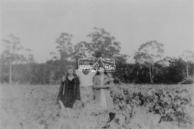
black and white photograph, C1916
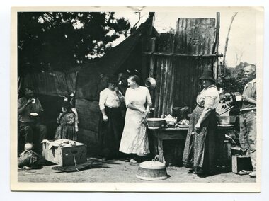
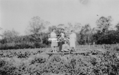
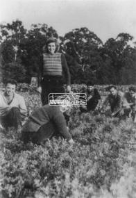
... , and closed in 1987. The station was located on the west side..., and closed in 1987. The station was located on the west side ...This is a photograph of a railway camp, set up to house workers and their families when building the Bairnsdale to Orbost Railway in 1916. The Bairnsdale-Orbost railway was opened in 1916 to serve the agricultural and timber industry. Because of the decline in traffic and heavy operating costs, the line was finally closed in August, 1987. Orbost Railway Station was opened on Monday 10 April 1916 as the terminus of the Orbost railway line, and closed in 1987. The station was located on the west side of the Snowy River despite the town of Orbost being on the east side of the river, in order to save on the costs of a bridge over the river, which at the time had highly variable levels.This item is associated with the history of the Orbost-Bairnsdale railway line and therefore reflects the role that the rail line played in the social and economic history of Orbost.A black / white photograph of a campsite kitchen. The kitchen is outside against a roughly constructed hut. There are three women preparing food. Two men are drinking from tin mugs. a small child is crawling on the ground and another is seated.on back - "Railway Camp"orbost-railway newmerella-railway-camp transport -
 Eltham District Historical Society Inc
Photograph, Guildo Fabbro, Falkiner Street, Eltham with Clydesdale horse
... the area on the west side of Falkiner Street was purchased... the area on the west side of Falkiner Street was purchased ...Guildo Fabbro, Falkiner Street, Eltham with Clydesdale horse with harness in field. The site of the Fabbro farm (Diamond Creek side land) is now called Barrack Bushlands. It is doubtful that Fabbro's farm holding was ever called Barrak Park, This title is fairly recent after the Shire of Eltham purchased the land, including the last section in 1993/94. About this time the area on the west side of Falkiner Street was purchased by a private developer and developed as housing. The area in Bell Street opposite the Eltham High School was purchased by the State Government is recent years and is called Fabbro Fields. The Fabbro Family operated their farm in Bell Street, Eltham. 1 black and white photographfabbro's farm, guido fabbro, bell street, clydesdale horse -
 Ballarat Tramway Museum
Postcard, Valentine & Sons Publishing Co, "Lydiard Street showing George Hotel Ballarat", 1931
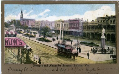
... , tram 27 in ESCo colour scheme, and buildings on the west side..., and buildings on the west side of Lydiard St North, including the George ...Valentine Series postcard of the early 1930s of No. 27 inbound in Lydiard St Nth. Valentine series No. 1492, with the caption "Lydiard Street showing George Hotel, Ballarat". See page 59 of The Golden City and its Tramways and for the photo itself. Photo shows the wooden centre poles, street lighting, tram 27 in ESCo colour scheme, and buildings on the west side of Lydiard St North, including the George Hotel, A.M. Palmer & Co Chemist, Wm Hiscock Dentist and other buildings. A horse-drawn cart and two motor cars parked at the kerb. See 3893 for a digital image and reproduction photograph.Yields information about Lydiard St Nth in the 1930's, the centre poles, traffic and the appearance of the trams.Postcard black and white, divided back. Card No. 1492Has on the rear in pencil "KT" and "to be copied" tramways, trams, tram 27, lydiard st nth, george hotel, centre poles -
 Kiewa Valley Historical Society
Saucepan, circa mid to late 1900's
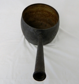
... " on the other side "WEST BROMWICH 5 QUARTS"... On bottom of pan (underside) "N0. 8 JSJ SIDDONS" on the other side ...This large deep pan (with a long handle) was used by pioneer families, mainly rural folk, that needed a pan which could cope with an open fire heat source, in or mainly outside the homestead. This pan was used in the early to late 1900's for the "stews" and other meals required by hard working stock men and farmers that had irregular "lunch and dinner" breaks under sometimes hard and gruelling conditions. Hot plates were normally not in use.This "open fire" saucepan belonged, and was used by a Kiewa Valley, pioneer family, the Roper Family. This saucepan was moved from their Kiewa Valley property to their hut built on the Bogong High Plains. This saucepan was one of an array of "open fire" cooking utensils used in the "camp draft" grazing in the Bogong High Plains and this could take up to six weeks. This kettle belonged and was used by a Kiewa Valley, pioneer family, the Roper Family. This kettle was moved from their Kiewa Valley property to their hut built on the Bogong High Plains. A scientific study started in 1947 to study the impact of grazing cattle on the natural Alpine and sub Alpine vegetation found grazing cattle had an adverse affect on the natural Alpine and sub alpine vegetation, and grazing on the plains was stopped by the Victorian Government in 2005.This large (black, soot infused) cast iron saucepan has a "ten pint" holding capacity and was used on the "open fire", possible on the fire direct. It has a long all metal handle coming from the top half of the pot and angled at approximately sixty degrees upwards. This angle insures that both distance from flame intensity and least bending of knees when lifting is at a minimum.On bottom of pan (underside) "N0. 8 JSJ SIDDONS" on the other side "WEST BROMWICH 5 QUARTS"camp fire cooking utensils, hot plate, cast iron cooking appliance, drovers kitchen -
 Charlton Golden Grains Museum Inc
Photograph
... Early photograph of the west end, northern side of High St...Early photograph of the west end, northern side of High St ...Early photograph of the west end, northern side of High St Charlton 1880's. Globe Hotel built 1874, Mounted, sepia toned photograph of High St Charlton looking north west. Buildings left to right: residence, Mechanics Institute, general store, shop, Stowe's fruit & veg shop, Globe Hotel, bank (?), T.H. Jackson butcher, O'Sullivan Paintermechanics institure, stowes, globe hotel, t.h.jackson butchers, o'sullivan painter, high street, charlton -
 Eltham District Historical Society Inc
Photograph, Maurie Fabbro at age 20 at Fabbro's farm in Bell Street, Eltham, 1940, 1940
... The site of the Fabbro farm (Diamond Creek side land... melbourne The site of the Fabbro farm (Diamond Creek side land ...The site of the Fabbro farm (Diamond Creek side land) is now called Barrack Bushlands. It is doubtful that Fabbro's farm holding was ever called Barrak Park, This title is fairly recent after the Shire of Eltham purchased the land, including the last section in 1993/94. About this time the area on the west side of Falkiner Street was purchased by a private developer and developed as housing. The area in Bell Street opposite the Eltham High School was purchased by the State Government is recent years and is called Fabbro Fields. The Fabbro Family operated their farm in Bell Street, Eltham. Maurice Joseph Fabbro (Mario) was born 19 January 1920 and passed away 19 November 20091 black and white photographfabbro's farm, maurice fabbro -
 Orbost & District Historical Society
box, first half 20th century
... on the west side of the Snowy River despite the town of Orbost being... on the west side of the Snowy River despite the town of Orbost being ...This box was used by Lindsay Thomson's mother, Annie M. Thomson for the transport of hen eggs from Orbost to Melbourne by rail - C 1940's -1950's. The Bairnsdale-Orbost railway was opened in 1916 to serve the agricultural and timber industry. Because of the decline in traffic and heavy operating costs, the line was finally closed in August, 1987. Orbost Railway Station was opened on Monday 10 April 1916 as the terminus of the Orbost railway line, and closed in 1987. The station was located on the west side of the Snowy River despite the town of Orbost being on the east side of the river, in order to save on the costs of a bridge over the river, which at the time had highly variable levels. This item is associated with the history of the Orbost-Bairnsdale railway line and therefore reflects the role that the rail line played in the social and economic history of Orbost. A wooden box with two inside sections and a wooden lid which is secured on both ends by large nails/spikes which are fitted into a groove and are then turned. On front and back in black stencilled letters A M T O B container railway eggs -
 Port Melbourne Historical & Preservation Society
Photograph - Demolition, Joshua Bros/UDL distillery buildings, Pickles Street, Port Melbourne, 26 Oct 2002
... St but looking to the West side of the complex including... spot on Rouse St but looking to the West side of the complex ...Digital copies of two colour photographs taken 26.10.2002 showing the demolition of the former Joshua Bros/UDL distillery building on Pickles St. The site was to become the ID apartment complex. .01 - Viewed from Rouse St looking East towards the city with "Portside" apartments at the rear. Retained walls are to the right, on Pickles St, where some of the walls are decoated with paintings of UDL products. .02 - taken from the same spot on Rouse St but looking to the West side of the complex including other apartments on Johnston St and again with "Portside " apartments at the rear.built environment - domestic, built environment - industrial, joshua brothers distillery, udl, sheridan property, id apartments, portside apartments, pickles street -
 Ballarat Tramway Museum
Photograph - Black & White Photograph/s, The Courier Ballarat, 25/05/1970 12:00:00 AM
... side, along with the remains of the tree, and shops on the west..., and shops on the west side, including Dickins Food Stores ...Yields information about Ballarat's tramway system Sebastopol route, where the tram crossed to the side of the road and the streetscape at that point.Black and White copy photograph taken by The Courier, published 25/5/1970 of No. 18, Albert St & Rubicon St corner, showing remains of tree that had previously impeded motorists' view of trams. Shows the Ford dealership on the left hand side, along with the remains of the tree, and shops on the west side, including Dickins Food Stores, a newsagent and a chemist. Collected by Alan Bradley from the Ballarat Courier early 1980's. See Excel file "Record of Ballarat Courier Photos SEC era" (Archive Documents) for source of details.On rear stamped "Copyright, The Ballarat Courier Proprietary Limited."tramways, trams, albert st, sebastopol, tram 18 -
 Eltham District Historical Society Inc
Negative - Photograph, Tom Prior, Langlands Bridge, Eltham, c.1900
... as ‘Ihurst’ on the west side of Diamond Creek to the south of John... as ‘Ihurst’ on the west side of Diamond Creek to the south of John ...It is noted in the Reynolds Prior collection (Ivy Reynolds) as the first bridge in Eltham however given the current state of knowledge, this is considered unlikely and there is no other supporting source. John Hunter Langlands, owner of the farm known as ‘Ihurst’ on the west side of Diamond Creek to the south of John Wright Murray’s land, died in 1907. In 1909 his land was subdivided into 100 lots to become the ‘Glen Park Estate’. It is possible that the bidge may have crossed the Diamond Creek to Langland's land along the original alignment of Glen Park Road which used to run between present day Progress Road and Coleman Crescent. SEPP Source (c.1970): Mrs. E.R. Reynolds, Thompson Crescent, Research The Reynolds family were early settlers in Research. The Reynolds/ Prior collection of photographs were taken by Tom Prior, the maternal uncle of Ivy Reynolds, around 1900 and the 60 photos in the album give a fine overview of many of the landmarks of Research and Eltham over 100 years ago. lvy lived in the family home for many years at 106 Thompson Cres Research. Ivy's father, Ernst Richard Reynolds and grandfather, Richard Reynolds, lived at the same address. Ivy's father Richard worked for Mr. Trail on his property in Research. Reynolds Road is named after the family. Mr Tom Prior (wife Eva) worked at the Melbourne zoo. He was very innovative and made his own camera, using the black cloth hood to exclude the light. The photographs are a reminder of the rural nature of Research and Eltham and its rich heritage. This photo forms part of a collection of photographs gathered by the Shire of Eltham for their centenary project book,"Pioneers and Painters: 100 years of the Shire of Eltham" by Alan Marshall (1971). The collection of over 500 images is held in partnership between Eltham District Historical Society and Yarra Plenty Regional Library (Eltham Library) and is now formally known as the 'The Shire of Eltham Pioneers Photograph Collection.' It is significant in being the first community sourced collection representing the places and people of the Shire's first one hundred years.Digital image 4 x 5 inch B&W Neg B&W printsepp, shire of eltham pioneers photograph collection, eltham, langlands bridge, reynolds prior collection, bridge, john hunter langlands -
 Eltham District Historical Society Inc
Photograph, From left: Unknown, Mario Fabbro and possibly Helen Skipper, Bell Street, Eltham
... of a vegetable crop. The site of the Fabbro farm (Diamond Creek side land... of a vegetable crop. The site of the Fabbro farm (Diamond Creek side land ...At Bell Street, Fabbro Farm, Eltham; From left: Unknown, Mario Fabbro and possibly Helen Skipper, standing in the middle of a vegetable crop. The site of the Fabbro farm (Diamond Creek side land) is now called Barrack Bushlands. It is doubtful that Fabbro's farm holding was ever called Barrak Park, This title is fairly recent after the Shire of Eltham purchased the land, including the last section in 1993/94. About this time the area on the west side of Falkiner Street was purchased by a private developer and developed as housing. The area in Bell Street opposite the Eltham High School was purchased by the State Government is recent years and is called Fabbro Fields. The Fabbro Family operated their farm in Bell Street, Eltham. 1 black and white photographfabbro's farm, bell street, eltham, maurice fabbro, farming, helen skipper, vegetables -
 Eltham District Historical Society Inc
Photograph, Fabbro's farm, Bell Street, Eltham, c.1990s
... in 1993/94. About this time the area on the west side of Falkiner... in 1993/94. About this time the area on the west side of Falkiner ...Fabbro's farm and house, Bell Street, Eltham, c.1990s. A crop of artichokes were planted on the farm at this time. The site of the Fabbro farm (Diamond Creek side land) is now called Barrack Bushlands. It is doubtful that Fabbro's farm holding was ever called Barrak Park, This title is fairly recent after the Shire of Eltham purchased the land, including the last section in 1993/94. About this time the area on the west side of Falkiner Street was purchased by a private developer and developed as housing. The area in Bell Street opposite the Eltham High School was purchased by the State Government is recent years and is called Fabbro Fields. The Fabbro Family operated their farm in Bell Street, Eltham. 1 colour photograph printed with white borderfabbro's farm, bell street, eltham, artichokes, barak farm -
 Eltham District Historical Society Inc
Photograph, Artichokes growing at Bell Street, Eltham, c.1990s
... in 1993/94. About this time the area on the west side of Falkiner... in 1993/94. About this time the area on the west side of Falkiner ...Fabbro's farm and house, Bell Street, Eltham, c.1990s. A crop of artichokes were planted on the farm at this time. The site of the Fabbro farm (Diamond Creek side land) is now called Barrack Bushlands. It is doubtful that Fabbro's farm holding was ever called Barrak Park, This title is fairly recent after the Shire of Eltham purchased the land, including the last section in 1993/94. About this time the area on the west side of Falkiner Street was purchased by a private developer and developed as housing. The area in Bell Street opposite the Eltham High School was purchased by the State Government is recent years and is called Fabbro Fields. The Fabbro Family operated their farm in Bell Street, Eltham. 1 colour photograph printed with white borderfabbro's farm, bell street, eltham, artichokes, barak farm -
 Eltham District Historical Society Inc
Photograph, Maurice Fabbro with artichokes growing at Bell Street, Eltham, c.1990s. Maurie is in his 70s
... in 1993/94. About this time the area on the west side of Falkiner... in 1993/94. About this time the area on the west side of Falkiner ...Fabbro's farm and house, Bell Street, Eltham, c.1990s. A crop of artichokes were planted on the farm at this time. The site of the Fabbro farm (Diamond Creek side land) is now called Barrack Bushlands. It is doubtful that Fabbro's farm holding was ever called Barrak Park, This title is fairly recent after the Shire of Eltham purchased the land, including the last section in 1993/94. About this time the area on the west side of Falkiner Street was purchased by a private developer and developed as housing. The area in Bell Street opposite the Eltham High School was purchased by the State Government is recent years and is called Fabbro Fields. The Fabbro Family operated their farm in Bell Street, Eltham. 1 colour photograph printed with white borderfabbro's farm, bell street, eltham, artichokes, barak farm, maurice fabbro -
 Port Melbourne Historical & Preservation Society
Photograph - Domestic and business structures, Port Melbourne, Ron Laing, 1986 - 1999
... , house cnr Graham and Albert, west side; only surviving milk bar..., building cnr Stokes and Graham, house cnr Graham and Albert, west ...Part of Ron Laing's collection of photographs recording Port Melbourne over a thirteen year period. Donated to the PMH&PS by the photographer.A set of colour photographs of Port Melbourne domestic and business structures, c1999, including new house at 31 Ross, former Masonic Hall at 18 Stokes St (1858), New houses on old J&R Garage site, Graham and Clarke St, new housing project on Walsh Transport Depot in Albert Street, building cnr Stokes and Graham, house cnr Graham and Albert, west side; only surviving milk bar within a radius of 100m from cnr Graham and Albert; ex-butcher shop/ex-chicken shop, 400 Graham Streetbuilt environment - domestic, built environment - commercial, business and traders, ron laing -
 Ballarat Tramway Museum
Newspaper, The Courier Ballarat, "A growing, young ambition to pull a tram", 26/05/2003 12:00:00 AM
... pulling on the rope connected to the tram on the west side... of Ballarat pulling on the rope connected to the tram on the west side ...Newspaper cutting from page 2 of The Courier, Ballarat, 26 May 2003, titled "A growing, young ambition to pull a tram", reporting on the event at Lake Wendouree the previous day. Photograph features Anna Howley from the University of Ballarat pulling on the rope connected to the tram on the west side of Gardens Loop. Tram has the "Power 103.1 FM" banner on the front. Photo by Ian Wilson of the Ballarat Courier and report by Catherine Best. Quotes Allister Morrison of the Young Ambition and that they raised $8,000 for Pinarc Support Services. See also Reg. Item 2451 for event programme.date of newspaper cutting and page number in pencil and bottom of sheet.young ambition, tram pull, btm, rotary ballarat -
 Kew Historical Society Inc
Plan - Subdivision Plan, J R Mathers & McMillan, Myrtle Hill Estate, East Kew, circa 1949, c.1949
... of Myrtle Hill is shown on the west side of Bowyer Avenue..... The outline and building profile of Myrtle Hill is shown on the west ...The Kew Historical Society's map collection includes a substantial number of real estate subdivision plans, mainly of Kew but also of surrounding suburbs in Melbourne. Most of the subdivision plans date from the 1920s and 1930s when the districts old homes and local farmland were being split up to accommodate residential growth in the postwar period. These early plans were assembled by a local firm, Jas R Mather & McMillan, which had an office in Cotham Road. Many of the plans, and sometimes photos, were annotated by the agents.Subdivision plans are historically important documents used as evidence for the growth of suburbs in Australia. They frequently provide information about when the land was sold as well as evidence relating to surveyors and real estate and financial agents. The numerous subdivision plans in the Kew Historical Society's collection represent working documents, ranging from the initial sketches made in planning a subdivision to printed plans on which auctioneers or agents listed the prices for which individual lots were sold. In a number of cases, the reverse of a subdivision plan in the collection includes a photograph of a house that was also for sale by the agent. These photographs provide significant heritage information relating house design and decoration, fencing and household gardens.The photograph may also be aesthetically significant depending on the importance of the photographic atelier.Myrtle Hill, at 14 Vista Avenue, Kew, is of local historical and architectural significance as a good example of a large and imposing single-storey Italianate house of the early 1870s surviving in Kew. Originally sited on a large allotment overlooking Normanby Road, the setting of the house has been dramatically altered through extensive subdivision and development. The subdivision plan of the ‘Myrtle Hill Estate’ indicates that in one such subdivision, 11 allotments were created fronting Bowyer Avenue, Myrtle Avenue, and Normanby Road. The outline and building profile of Myrtle Hill is shown on the west side of Bowyer Avenue.The full (typed) title of this subdivision plan is :"Plan of SUBDIVISION of part of CROWN PORTION 83. / at KEW / PARISH OF BOROONDARA. / COUNTY OF BOURKE". / "MYRTLE HILL ESTATE / EAST KEW" In addition to the Title and subtitle, the plan also lists the advantages of the subdivision. -
 Kew Historical Society Inc
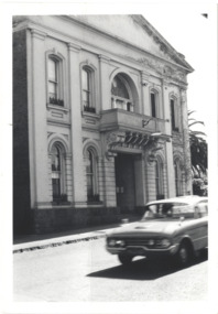
Photograph - Former Kew Town Hall, Walpole Street, 1970
... and Malmsbury Street, on the west side where Woolworth's supermarket now... Street between High Street and Malmsbury Street, on the west side ...The Municipality of Kew was granted independence in 1860. It was declared a borough in 1863, a town in 1910 and a city in 1921. In 1994, Kew was amalgamated into the new City of Boroondara.Black and white photographic positive of the front of the (former) Kew Town Hall in Walpole Street between High Street and Malmsbury Street, on the west side where Woolworth's supermarket now stands. The photograph, from August 1970 shows the detailing of the Italianate rendered-brick facade, added in the 1880s when the hall was renovated. The earliest building on the site was the Kew Athenaeum Hall (built 1860) which was purchased by Kew Council in 1865. The Town Hall was sold to Woolworth's and subsequently demolished in 1972 when the civic offices were transferred to a new building on the corner of Charles Street and Cotham Road."Old Kew Town Hall / Walpole St / Aug 1970/ Gift of Stewart West 1990"kew town hall -- walpole street, local government -- kew, civic buildings -- kew (vic.), town halls -- melbourne (vic.) -
 Kew Historical Society Inc
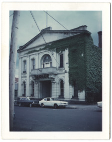
Photograph - Former Kew Town Hall, Walpole Street, 1972
... and Malmsbury Street, on the west side where Woolworth's supermarket now... High Street and Malmsbury Street, on the west side where ...The Municipality of Kew was granted independence in 1860. It was declared a borough in 1863, a town in 1910 and a city in 1921. In 1994, Kew was amalgamated into the new City of Boroondara. In 1960, a new Town Hall in Cotham Road was opened. The Municipal Offices that had remained in the former Town Hall in Walpole Street until it was moved to the new Civic Centre on the corner of Cotham Road and Charles Street in 1972.This is a rare and important colour photograph of the Kew Municipal Offices (former Town Hall) taken on 11/2/1972 in the year that the building was demolished and replaced by a Safeway Supermarket.Colour photographic positive (polaroid) of the front of the (former) Kew Town Hall in Walpole Street between High Street and Malmsbury Street, on the west side where Woolworth's supermarket now stands. The photograph, taken in February 1972, shows the detailing of the Italianate rendered-brick facade, added in the 1880s when the hall was renovated. The earliest building on the site was the Kew Athenaeum Hall (built 1860) which was purchased by Kew Council in 1865. The Town Hall was sold to Woolworth's and subsequently demolished in 1972 when the civic offices were transferred to a new building on the corner of Charles Street and Cotham Road.kew town hall -- walpole street, local government -- kew, town halls -- melbourne (vic.) -
 Glen Eira Historical Society
Album - Album page, Hawthorn Road, Circa 1972
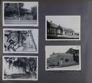
... HAWTHORN RD / WEST SIDE - SOUTH OFF BALACLAVA ROAD [under bottom... / WEST SIDE - SOUTH OFF BALACLAVA ROAD [under bottom right photo ...This photograph is part of the Caulfield Historical Album 1972. This album was created in approximately 1972 as part of a project by the Caulfield Historical Society to assist in identifying buildings worthy of preservation. The album is related to a Survey the Caulfield Historical Society developed in collaboration with the National Trust of Australia (Victoria) and Caulfield City Council to identify historic buildings within the City of Caulfield that warranted the protection of a National Trust Classification. Principal photographer thought to be Trevor Hart, member of Caulfield Historical Society. Most photographs were taken between 1966-1972 with a small number of photographs being older and from unknown sources. All photographs are black and white except where stated, with 386 photographs over 198 pages. 17 Hawthorn Road, North Caulfield is a contributory building to HO14 Caulfield North and environs, Caulfield North - Heritage Precinct in the City of Glen Eira.Page 83 of Photograph Album with five portrait photographs of 3 different properties on Hawthorn Road. Addresses are handwritten underneath each property.Handwritten: 17 HAWTHORN ROAD [under top left photo] / 17 HAWTHORN ROAD [under middle left photo] / 17 HAWTHORN ROAD [under bottom left photo] / 158-162 HAWTHORN ROAD [under top right photo] // STATE SAVINGS BANK CAULFIELD WEST BRANCH / 144 HAWTHORN RD / WEST SIDE - SOUTH OFF BALACLAVA ROAD [under bottom right photo] / 83 [bottom left] trevor hart, caulfield, hawthorn road, verandahs, houses, shops, banks, state savings bank, caulfield west, caulfield north, tudor style, victorian style -
 Eltham District Historical Society Inc
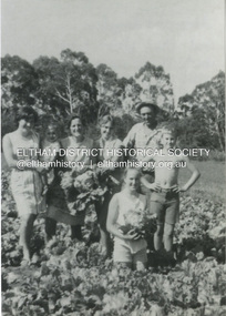
Photograph, At Bell Street, Eltham; from left: Helen Skipper, Matcham Skipper, Sonia Skipper and possibly Myra Skipper
... the area on the west side of Falkiner Street was purchased... the area on the west side of Falkiner Street was purchased ...At Bell Street, Fabbro Farm, Eltham; From left: Helen Skipper, Matcham Skipper, Sonia Skipper and possibly Myra Skipper, standing in the middle of a vegetable crop. The site of the Fabbro farm (Diamond Creek side land) is now called Barrack Bushlands. It is doubtful that Fabbro's farm holding was ever called Barrak Park, This title is fairly recent after the Shire of Eltham purchased the land, including the last section in 1993/94. About this time the area on the west side of Falkiner Street was purchased by a private developer and developed as housing. The area in Bell Street opposite the Eltham High School was purchased by the State Government is recent years and is called Fabbro Fields. The Fabbro Family operated their farm in Bell Street, Eltham. 1 black and white photographfabbro's farm, bell street, eltham, farming, helen skipper, vegetables, matchcam skipper, myra skipper, sonia skipper -
 Orbost & District Historical Society
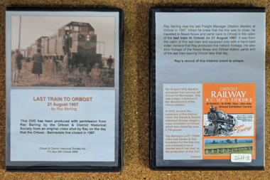
D.V.D. s, Last Train to Orbost, 21.8.1987
... . The station was located on the west side of the Snowy River despite.... The station was located on the west side of the Snowy River despite ...These are copies of an original video shot by Ray Barling on the day that the Orbost-Bairnsdale line closed in 1987. He used a hand-held video camera from his cabin on the train, The video was shown at the 2016 Centenary Exhibition in Orbost. The Bairnsdale-Orbost railway was opened in 1916 to serve the agricultural and timber industry. Because of the decline in traffic and heavy operating costs, the line was finally closed in August, 1987. Orbost Railway Station was opened on Monday 10 April 1916 as the terminus of the Orbost railway line, and closed in 1987. The station was located on the west side of the Snowy River despite the town of Orbost being on the east side of the river, in order to save on the costs of a bridge over the river, which at the time had highly variable levels. This item is associated with the history of the Orbost-Bairnsdale railway line and therefore reflects the role that the rail line played in the social and economic history of Orbost. On April 10 1916, the first scheduled train service left Orbost for Bairnsdale. The Bairnsdale-Orbost railway was opened to serve the agricultural and timber industry. Because of the decline in traffic and heavy operating costs, the line was finally closed in August, 1987. Orbost Railway Station was opened on Monday 10 April 1916 as the terminus of the Orbost railway line, and closed in 1987. The station was located on the west side of the Snowy River despite the town of Orbost being on the east side of the river, in order to save on the costs of a bridge over the river, which at the time had highly variable levels, The video was shown for the first time at the Centenary Exhibition held in Orbost, by the Orbost & District Historical Society, t created much interest leading to the production of the videos.Two copies of a D.V.D. titled"Last Train To Orbost 21 August 1987". The cover is a photo of the last train.rail-closure orbost-bairnsdale-railway -
 Eltham District Historical Society Inc
Photograph, Antonio and Angelina Casonato and family
... . About this time the area on the west side of Falkiner Street.... About this time the area on the west side of Falkiner Street ...Antonio and Angelina Casonato with their four children and a baby cousin taken with lettuces growing on the river flat at Bell Street, Fabbro Farm (Fabbro Fields) in front of Eltham High School in the late 1960s. The site of the Fabbro farm (Diamond Creek side land) is now made up of Fabbro Fileds and Barrack Bushlands. This title is fairly recent after the Shire of Eltham purchased the land, including the last section in 1993/94. About this time the area on the west side of Falkiner Street was purchased by a private developer and developed as housing. The area in Bell Street opposite the Eltham High School was purchased by the State Government is recent years and is called Fabbro Fields. The Fabbro Family operated their farm in Bell Street, Eltham. 1 black and white photograph reproduction print (low quality)fabbro's farm, bell street, eltham, farming, vegetables, angelina casonato, antonio casonato, fabbro family, fabbro farm, fabbro fields -
 Eltham District Historical Society Inc
Photograph, At Bell Street; from left: Maurie Fabbro, Myra Skipper, Unknown, Arthur Munday, Ian Robertson. Helen Comprione in front
... in 1993/94. About this time the area on the west side of Falkiner... in 1993/94. About this time the area on the west side of Falkiner ...At Bell Street, Fabbro Farm, Eltham; from left: Maurie Fabbro, Myra Skipper, Unknown, Arthur Munday, Ian Robertson. Helen Comprione in front - probably helping to pick a crop. The site of the Fabbro farm (Diamond Creek side land) is now called Barrack Bushlands. It is doubtful that Fabbro's farm holding was ever called Barrak Park, This title is fairly recent after the Shire of Eltham purchased the land, including the last section in 1993/94. About this time the area on the west side of Falkiner Street was purchased by a private developer and developed as housing. The area in Bell Street opposite the Eltham High School was purchased by the State Government is recent years and is called Fabbro Fields. The Fabbro Family operated their farm in Bell Street, Eltham. 1 black and white photographfabbro's farm, guido fabbro, bell street, arhur munday, eltham, helen comprione, ian robertson, maurice fabbro, myra skipper, picking, farming -
 Linton and District Historical Society Inc
Photograph, Carrie Murrell outside Murrell's Newsagency, Linton
... . In 1932 she moved the business from its site on the west side.... In 1932 she moved the business from its site on the west side ...Carrie Rogers Murrell, b.1905 at Daylesford, was a daughter of William Murrell and his wife Lily, née Clarke/Young. She was a grand-daughter of Ambrose and Mary Murrell. Carrie Murrell attended Linton State School, completing Grade 8 in 1n 1918. She then assisted her father in the Linton newsagency, before taking over as its manager, a role she enjoyed for some seventy years. In 1932 she moved the business from its site on the west side of Sussex Street to the east side, into a shop next to the Railway Hotel that had previously been run as a shoe shop by Dan Cornish. This shop remained as the Linton Newsagency until Carrie retired. It is now used as a private residence. Carrie Murrell died in 1998.Colour photo of Murrell's Newsagency, Miss Murrell seated in front doorway.carrie murrell, linton newsagency -
 Linton and District Historical Society Inc
Photograph, Traquair House, Sussex Street, Linton, 2014
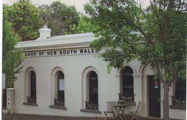
... South Wales built a new banking chamber & residence on the west... South Wales built a new banking chamber & residence on the west ...The original bank and residence were built in 1862, and the building was extended in 1873-74. The three windows on the left of the photograph are in the original building, and the windows and door on the right of the photograph are in the extension. The brick building was cement-rendered at an unknown later date. In 1904 the Bank of New South Wales built a new banking chamber & residence on the west side of Sussex Street next to the Post Office, after which the earlier building became a private residence. It was lived in for many years by members of the Lewers family (Samuel Lewers had been first manager of the Bank of NSW in Linton) and was purchased in the early 1960s by Stella Surman (née Todd). More recently it has been used as an antique shop and tea rooms, and it is currently a private residence. This photograph was taken in 2014 by Gary Hunt.One of three colour photographs printed on a single sheet of photographic paper. The photograph shows Linton's first Bank of New South Wales building, now called Traquair House.traquair house, 90 sussex street linton, buildings, houses, bank of new south wales -
 Ballarat Tramway Museum
Slide - 35mm slide/s - set of 3, Dave Simpson, trams at the intersection of Sturt and Lydiard St - City terminus, late 1960's early 1970's
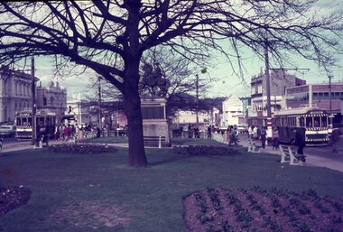
... - City terminus. 1 - view from the central median on the west... on the west side of Lydiard St, looking East with the Commonwealth ...Yields information about the intersection of Sturt and Lydiard Sts tramway centre and Boer War monument.Set of three 35mm slides - AGFA dark blue / white plastic mounts of trams at the intersection of Sturt and Lydiard St - City terminus. 1 - view from the central median on the west side of Lydiard St, looking East with the Commonwealth Bank, Post Office, with many passengers at the location. The Boer War monument /statue is in the centre part of the photograph. 2 - No. 14 about to turn into Lydiard St North/ The short tram stop and End of Section sign are adjacent to the tram. 3 - Tram waiting at the north side tram stop - has a Twin Lakes and Cinzano sign. Has the ANZ bank and the SEC offices in the background.tramways, trams, sturt st, city, lydiard st, passengers, signs, tram 14 -
 Ballarat Tramway Museum
Slide - 35mm slide/s, Peter Moses, 21/08/1971 12:00:00 AM
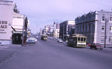
... buildings on the east and west side of Lydiard St. North. No. 26... buildings on the east and west side of Lydiard St. North. No. 26 has ...Photo of SEC Ballarat 26, with No. 14 and possibly No. 42 (Briquette roof advertisement and features on the same special trams in Reg. item 2064) waiting in Lydiard St. North for the arrival of the ARHS special on Saturday 21/8/1971 to undertake the last tour of Ballarat Tramways, prior to the closure of the system. The first line closure (Victoria St.) took place the following day. Has Reid's Coffee Palace building in the background and other buildings on the east and west side of Lydiard St. North. No. 26 has an SEC briquettes roof advertisement Kodak cardboard mount slide, taken by Peter Moses 21 August 1971.On back of slide in light black ink "Ballarat / ARHS outside station / special trams Lydiard St." and "P. Moses" in black ink in the upper right hand side of the slide.tramways, trams, arhs, lydiard st, tram 26 -
 Ballarat Tramway Museum
Slide - 35mm slide/s, Glen Mills, Sept. 1971
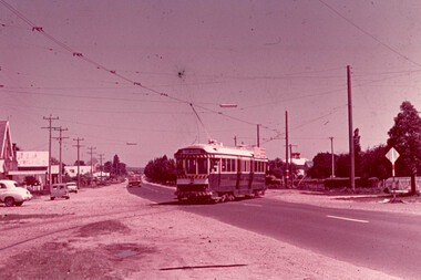
... crossed to the west side of the road. Here car No. 38 outbound...: "About 1/2 mile from the terminus the line crossed to the west ...White cardboard mount, 35mm slide, from the Association of Railway Enthusiast's film strip titled "Provincial Tramway Film Strip" of No. 38, crossing Albert St, southbound, with Destination of Sebastopol. Photo taken after tram has passed photographer. Has the Anglican Trinity church in the background. The film strip notes (Reg. Item 2560), provided the following caption details: "About 1/2 mile from the terminus the line crossed to the west side of the road. Here car No. 38 outbound bowls across the asphalt. - Nov. ' 70 (Glen Mills)" See image btm2576p.tif for high level scan of image. Stamped on base of slide "11786" and written in ink on top edge "No. 38 Sebastopol line Ballarat"tramways, trams, are, film strip, albert st, sebastopol, tram 38