Showing 10533 items
matching lander
-
 Ringwood and District Historical Society
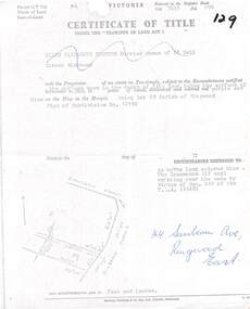
Document, Partial copy of Certificate of Title Vol 7635 Fol 096 Lot 29, 44 Sunbeam Avenue Ringwood East, Victoria
Black and white photocopied page with added notations in blue pen.Ellen Elizabeth Stanton, Married Woman of 35 Bell Street Richmond is now the Proprietor of an estate in Fee-simple, subject to the Encumbrances notified herunder in the surface down to the depth of fifty feet below the surface of the pie of land delineated and colored red purple and blue on the map in the margin, being Lot 29 Parish of Ringwood. Plan of Subdivision No. 12150. (undated). -
 City of Moorabbin Historical Society (Operating the Box Cottage Museum)
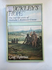
Book, Globe Press Pty. Ltd, Buckley's hope : the story of Australia's wild white man, 1981
A small soft cover book with a blue/green cover,on the front cover is a painting of early Australia with Indigenous Australians hunting with spears alongside them is a European with long unkept hair and a beard dressed in animal skins,on the back cover is text by the author giving a brief outline of the book.buckley, sorrento, robinson crusoe, port phillip, van diemen's land, colonialism, 1840, convicts, indigenous tribes. -
 Mt Dandenong & District Historical Society Inc.
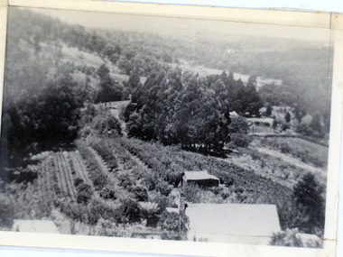
Photograph, 1913 View Over Logan's House in Village Settlement, 1913
Photograph taken in 1913 from Barbers Road showing the view down the valley. Roof in foreground is house on Bob Logan's Lot 28 in the Village Settlement. This photograph has a detailed inscription on the back handwritten by John Lundy-Clarke in 1974.1913 view over Logan’s house on Village Settlement Lot 28 taken from Barber’s Road. This is the house that the runaway log leaped over in 1930 to land far down the orchard row beyond the house. “Shiloah” is centre partly behind the clump of trees and the paddocks of Child and Richardsons pioneer selections are in the background. Link Road is centre right.logan, bob logan, robert logan, barbers road, shiloah, child, richardson, link road -
 Ringwood and District Historical Society
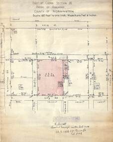
Document, 1926 Land Survey drawing of the area surrounding 1-5 City Road, Ringwood
Drawing on parchmentHand-drawn survey of what is now 1-5 City Road, Ringwood. Drawn by K Arndt, licensed surveyor, 237 Queen Street, Melbourne Tel 5118 on 25 September 1926. The block of land in question was 2 roods, 21 and 8/10 perches in size. The location was between Haig Street in the north, City Road in the south, Wantirna Road in the west and Victoria Road in the east. The Good Shepherd Retirement Village (Lutheran) now occupies the land. The drawing shows a number of existing weatherboard houses, fences and frontage sizes. A number of named roads were defined but no longer exist, these were Duffy Street (to the west), Evans Street (east) and Victoria Street (further east). Ireland Street still exists in the south. -
 Kew Historical Society Inc
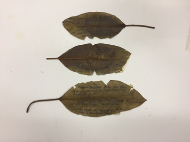
Plant specimen, Dorothy Rogers, Inscribed Moreton Bay Fig Leaves, Hawthorn (Vic), c.1960s
Collected by the historian Dorothy RogersDried Moreton Bay fig leaves from the vicinity of Palmer's Punt near Denham Street Hawthorn. Each leaf was inscribed by the historian Dorothy Rogers (sic) before 1973. The leaves are brittle and undated, with the text difficult to decipher. 1974.0010.1 "Moreton Bay fig leaf from old tree foot of Derham St Haw - vicinity Palmer's Punt until 1934 flood & hut for Punt passengers was still there. KH-355." 1974.0010.2 "Moreton Bay fig leaf from old tree foot of Denham St haw - vicinity Palmer's Punt until 1934 flood hut for punt passengers still existed there. A canoe tree in garden from Sir J. Palmer's land. KH-355." 1974.0010.3 "Moreton Bay fig leaf from old tree foot of Denham St leading to Palmer's Punt until 1934 flood there was still there a hut for punt passengers. Canoe tree in gardens from Sir J. Palmer's land. KH-355."denham street - hawthorn (vic), palmer's punt, invergowrie - hawthorn, 1934 flood - melbourne - hawthorn (vic) -
 Phillip Island and District Historical Society Inc.
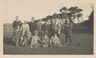
Photograph, Early 1920's
One of 5 photographs donated by Lyn Chambers & Frank Dominick - Wonthaggi Historical Society The following information was sent by a reader of VC for which we are very thankful. The golf course in San Remo was opened in 1922 and was on the land adjacent to Ocean Grove where Griffiths point lodge and Davis Point road now stand. One hole was placed on the flat land on the beach. There were red flags and the cows used to eat them. Black & White photograph of a group of people with their golf clubs. Noted on back of photo "San Remo Golf Links". A question mark re location as it seems too flat. Maybe it was in Cowes?? This has now been updated - see below under "Historical Information" 4/9/2016On back: San Remo Golf Links early 1920'sgolf links san remo, lyn chambers -
 Kiewa Valley Historical Society
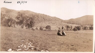
Black and white photograph of farmland, Kiewa, 25/8/38, circa 1938
This photograph was taken in August, 1938 at the time of road making in the area and some eight years prior to the establishment of Mt. Beauty township. The area was still being used for grazing, and the land was eventually acquired from the local land owners by the State Electricity Commission. The construction of the road, from Tawonga to the High Plains, was commenced in April of this year. This allowed men and heavy equipment to be transported to the work sites for the construction of the Kiewa Hydro Electric Scheme. An important photograph as it shows the upper Kiewa Valley as it was before the establishment of the town of Mt. Beauty. The land had been cleared of natural growth and has been used for grazing cattle. By 1946 housing construction had commenced for the new town of Mt. Beauty and by 1948 street construction in the southern part of the town was completed as far as Hill Street.A black and white photograph taken in the upper Kiewa Valley showing farmland with a group of three unidentified people sitting on the grass.Handwritten in black ink is the inscription 'Kiewa 25/8/1938'. In the right corner of the photograph has been stamped the number 6. On the back in a circle, some 14mm across, are the words 'Kodak Print'. The word Velox is also printed on the back.kiewa, mt. beauty, construction, grazing, secv -
 Melbourne Tram Museum
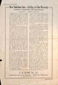
Pamphlet - Real estate sale, T M Burke, "New Suburban line - Darling to Glen Waverley", July 1926
Pamphlet advising potential land purchasers of the recommendation to extend the railway line from Darling to Glen Waverley, extracted from The Age 26/6/1926. Advises that the land and losses would be paid for by the residents through their rates. Gives costs of the proposed new line. Has a plan showing the estates for sale along the line, the Ashburton line (later extended to Alamein) and Burwood Road. Published by T M Burke Pty Ltd. Demonstrates the style of land sale pamphlet including the proposed availability of train services to prospective purchasers.Pamphlet - single quarto sheet with map on rear - printed.sale of land, real estate, railways, glen waverley, suburban railways -
 Warrnambool and District Historical Society Inc.
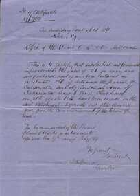
Document, Board of Land & Works 9 Feb 1869 Certify Improvements to land re Charles Stonehouse & James Carlisle, Circa 1870
This letter certifies that substantial and permanent improvements have been made to land in the Parish of Tallangatta Lot 50, which is near Allansford. The lease was to Charles Stonehouse.Part of a collection of letters relating to the Bostock family.Blue lined foolscap size sheet with writing in black ink. Writing is sideways on the backSigned by J M Grant, S Hopkinsallansford, charles stonehouse, james carlisle -
 Kiewa Valley Historical Society
Papers - Cattle Grazing, Bogong High Plains
Cattle grazing. In the 1990s government departments allocated the number of cattle being taken up to the Bogong High Plains by the families who traditionally leased land there.Cattle grazing had been banned in other Alpine areas due to concerns of their impact on the environment. Kiewa Valley cattle graziers were caught up in the controversy as it was their tradition dating back to the 1840s. This controversy continues as cattle grazing was banned in 2005. 4 pages with black print: 1. 1989/90 Cattle Grazing Allocation and Dept. of Conservation Forests and Lands, Wodonga. 2. Proposed Future Stock Allocations 1991/92 list of 16 families 3. & 4. List of families, ear marks, brands etc. dated 22nd Feb. 1979 stapled togetherex S.C.A. / Benalla / Received 22nd Feb. 1979 / signedcattle grazing, kiewa valley farmers -
 Eltham District Historical Society Inc
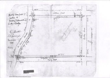
Document - Photocopy, Survey Fleld Notes of Part of Crown Portion 13, Section 4 at Eltham, Parish of Nillumbik, County of Evelyn, November 1909
Portion of land bounded by Main Road, Arthur Street, Bible Street, Henry Street Application 36708 K. Arndt, Licensed Surveyor, November 1909application 5289, arthur street, bible street, eltham, henry street, main road, map, survey plan -
 Eltham District Historical Society Inc
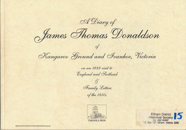
Folder, A Diary of James Thomas Donaldson of Kangaroo Ground and Ivanhoe, Victoria on an 1889 visit to England and Scotland & family letters of the 1850s, 1999
James Thomas Donaldson together with his family were pioneers in Kangaroo Ground from Scotland. James later bought land and built a house in Ivanhoe50 pages presented as transcriptions of original letters with images of some letters for illustration. Some black and white photos included. Also includes Photo of Alexander Donaldson with brief notes describing origin and some family history, 1pHG Booklet 10harry gilham collection, james thomas donaldson -
 Bendigo Military Museum
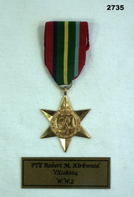
Award - MEDAL, Post WWII
ROBERT MACKENZIE KIRKWOOD initially enlisted No V32567 then transferred to AIF No VX118004 on 3.11.1942. At discharge from the Army 16.1.1946 he was a PTE in Advanced Land Headquarters. Pacific Star Medal with loose ribbon.VX118004 R M KIRKWOODmedals, military, history, passchendaele barracks trust -
 Phillip Island and District Historical Society Inc.
Photograph, 1978/79
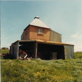
The Chicory Kiln shown in the photograph is situated on land owned by the McIlwraith family in the 1870s. It is at Heath Hill on the Rhyll-Newhaven Road and is one of the oldest on Phillip Island.Coloured photograph showing a Chicory Kiln on the property which belonged to the McIlwraith family.local history, photographs, buildings - historical, housing, rural industry, coloured photograph, john cook, phillip island, mcilwraith homestead -
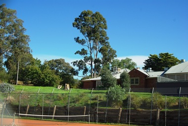
 Greensborough Historical Society
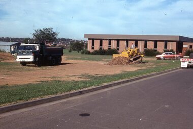
Photograph - Digital Image, Watsonia High School Pool Construction 1976. Groundwork begins, 12/12/1976
The swimming pool at Watsonia High School was commenced in 1976 and opened in 1977. This photo shows the commencement of groundwork for the pool, with construction vehicles on the land in front of the library.While the school has gone, the pool remains in 2019, operating as Yarra Swim School, Liat Way GreensboroughDigital copy of colour photograph, scanned from slide. Slide set at Item 6513.On slide "12/12/76"watsonia high school, swimming pools greensborough, yarra swim school -
 Greensborough Historical Society
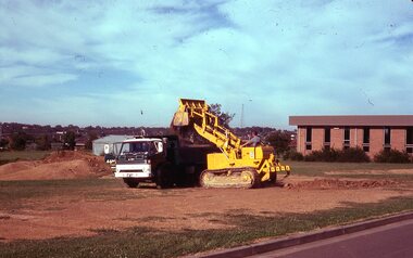
Photograph - Digital Image, Watsonia High School Pool Construction 1976. First digging, 12/12/1976
The swimming pool at Watsonia High School was commenced in 1976 and opened in 1977. This photo shows the commencement of groundwork for the pool, with construction vehicles on the land in front of the library.While the school has gone, the pool remains in 2019, operating as Yarra Swim School, Liat Way GreensboroughDigital copy of colour photograph, scanned from slide. Slide set at Item 6513.On slide "12/12/76"watsonia high school, swimming pools greensborough, yarra swim school -
 Greensborough Historical Society
Folder, Black Family Land Titles, 1891o
Collection of seven Certificates of Title for land in present-day Watsonia owned by members of the Black Family, ranging from 1891 to 1939, including transfers to 1967.Looseleaf folderblack family, watsonia -
![Photograph - Digital image, Willis Vale [Cows], 1920c](/media/collectors/4f729f5697f83e03086015b8/items/5502a0be2162f11024c30d9c/item-media/5502a0e52162f11024c31072/item-fit-380x285.jpg) Greensborough Historical Society
Greensborough Historical SocietyPhotograph - Digital image, Willis Vale [Cows], 1920c
Photograph of four cows at Willis Vale, home of the Partington family. It was located on the Plenty River at Partington's Flat Greensborough. Land use included farming and orchards. Home of the Partington familyDigital copy of black and white photograph.willis vale, partington -
 Greensborough Historical Society
Photograph - Digital image, Alwyn and tennis court 2014, 21/05/2014
In about 1945, Alan and Wyn Partington built a house (Alwyn) on 12 acres (now Whatmough Park) but this land was acquired by the Council for parkland and sports ovals. Digital copy of colour photograph.alwyn, alan partington, whatmough park -
 Greensborough Historical Society
Newspaper Clipping, Diamond Valley Leader, Uni offers to sell Strathallan Golf Course land, 30/08/2017
La Trobe University has offered to sell the Strathallan Golf Course land to Darebin Council after years of speculation over the future of the Bundoora site.News article 1 page, black text, colour image.la trobe university, strathallan golf course, darebin council -
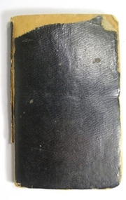 Yarra Ranges Regional Museum
Book, Receipt, Rent record book, Warburton
Bought by donor at a flea market. Receipt book for rent by Royce Bellman to James Dixon for a house and land in West Warburton, Victoria from 1915 - 1921. Small hard coverd navy blue book with lined pages. Paper receipts for rental payments by Royce Bellman to James Dixon are pasted onto the pages. Has ink inscriptions inside back and front covers ans addition sums written in pencil inside back cover. Inscibed in ink inside fron cover: Book of rental purchase between bellman and Dixon 101' per week Payable fortnightly from March 24th 1915. Inscibed in ink inside the back cover; Mrs JAmes Dixon 49 Stafford St Abbortsford Victoria post office 1910's, warburton, houses and housing -
 Tatura Irrigation & Wartime Camps Museum
Photograph, Arthur Knee, 1989
Camp 13 held German, Italian and Japanese POW's between 1941-1946. Has since reverted to grazing land. Owner Jim Finnegan of Murchison.Camp 13, Murchison, Victoria. Fence posts with concrete remains of kitchen and shower block beyond. German compound. Bare earth foreground, few eucalyptus.camp 13,, pow, murchison victoria, german pow's, internment camps -
Tatura Irrigation & Wartime Camps Museum
Photograph - original, Tatura Fruit Cannery, 1920 - 1922
Original photograph of T. Edwards and E. Quine (manager) in front of a fruit cannery, which operated for a short time on land near the Railway Station, Tatura.Black and white original photograph of 2 men outside Tatura's first cannery.on back: Tatura Cannery. T. Edwards, E. Quine. Presented to Tatura and District Historical Society by T. Flanagan. April 1985.tatura fruit cannery, t. edwards, e. quine -
Tatura Irrigation & Wartime Camps Museum
Carry Case, 1920
Used in conjunction with dumpy level, by Mr. Craven to survey agricultural land in the Goulburn Valley for the pruposes of setting out farm irrigation channels and check banksRectangular wooden box, divided into 5 sections with lid attached and closed with 2 metal fasteners on to 2 screws on the lid and key hole lock (no key). 2 leather straps with 2 buckles are attached by 2 metal bars, small screw driver and metal cap from telescope on dumpy level.carry case, dumpy level, craven b, tatura, surveying, irrigation, terrestrial -
Stawell Historical Society Inc
Book - Report, Grampians: A Report on recreation and Timber Uses of. Too Steep to Graze - Too Rocky to Plough, 1979
1) Conservation & Economics 2) Grampians Study Area 3) Land Use 4) Management 5) Criticisms of the Management Plan Appendix Graphs & MapsGreen Paper cover: Black tape on SpineConservation council of Victoria and Logo -
 City of Kingston
Pamphlet - Colour, Duffus Bros, Railway Reserve Highett, c. 1923
Sales plan for land in the suburb of Highett, titled Railway Reserve, incorporating properties along Wolseley Street, Livingston Street, Highett Road and Worthing Road. The developing urban area of Highett within the City of Kingston. This land sale pamphlet illustrates the subdivision of land within the municipality and the changing demographic of the district as new houses and shops are constructed close to infrastructure.Colour pamphlet advertising thirty eight shop and villa sites for sale at the Railway Reserve, Highett. Incorporates a map of the reserve with properties available on Wolseley Street, Livingston Street, Highett Road and Worthing Road. Handwritten in grey pencil: assumed sale price recorded on subdivisions 1-7, 10, 22, 23 and 34 Handwritten in grey pencil on subdivision 4: C. Nevill / City of Melbourne bank Handwritten in grey pencil across subdivision 7: 49' Handwritten in grey pencil across subdivision 21 and 22: 134' Handwritten in grey pencil across subdivision 25 and 26: 200' Handwritten in grey pencil across subdivision 36 and 37 and both top and bottom: 120' Hand drawn in blue pencil: outline of subdivision 4 Hand drawn in blue pencil: outline of subdivisions 7, 23, 28, 37, 38 along left hand side, subdivisions 38, 37 and 36 on Wolseley Street, subdivisions 30 and 29 along Wolseley Street, subdivisions 29 and 24 along the middle of the plan, subdivisions 24 and half of 25 along Livingston Street, half of subdivision 20 along the middle of the plan, subdivisions 21 and 22 along the Right of Way between Livingston Street and Highett Road, and along the right hand border of subdivision 7. Handwritten in ink adjacent to the subdivision plan, updside down, in the bottom right hand corner: 276 / 54 / 280 / 45 / 320 / 202 / 200 / 134 / horizontal line / 11/14 Handwritten in ink adjacent to the subdivision plan, updside down, in the bottom right hand corner: 1714)2200(15 / 1714 / horizontal line / 486land sales, highett -
 City of Kingston
Pamphlet - Colour, S. M. Reynolds, Estate Agent, Moorabbin Shire Hall Estate Second Section, c. 1930
Sales plan for land in the suburb of Moorabbin, bounded by South Road and Highbury Street, including Prince Street, Charming Street, Thomas Avenue and Keith Road.The developing urban area of Moorabbin within the City of Kingston. This land sale pamphlet illustrates the subdivision of land within the municipality and the changing demographic of the district as new houses are constructed close to infrastructure.Colour pamphlet advertising for private sale the Moorabbin Shire Hall Estate, Moorabbin. Incorporates a map of the estate bordered by South Road and Highbury Street, including Prince Street, Charming Street, Keith Road and Thomas Avenue.Handwritten in grey pencil on subdivision map below subdivision 63: £4 Handwritten in grey pencil on subdivision map below subdivision 66: 4 Handwritten in grey pencil on subdivision map below subdivision 80: 3. Handwritten in grey pencil on subdivision map below subdivision 81: 4 Handwritten in grey pencil on subdivision map below subdivision 83: 2 Handwritten in grey pencil on subdivision map below subdivision 96: £3 Handwritten in grey pencil on subdivision map below subdivision 97: 3 Handwritten in grey pencil on subdivision map to the left of subdivision 102: 3 Handwritten in grey pencil on subdivision map on the corner of Thomas Avenue and Highbury Street: vertical line next to a square with a cross in it.land sales, estate, moorabbin -
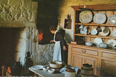 Sunbury Family History and Heritage Society Inc.
Postcard, Jocelyn Burt, Kitchen at Emu Bottom Homestead
The postcard shows the kitchen at 'Emu Bottom' which is almost the same as when the homestead was built in the 1930s when George Evans acquired the land and built the homestead.Images like the one on the postcard provide visual information relating to past domestic living and life.A non-digital coloured photograph in post card format with a crinkled edge, of a lady in a kitchen cooking over a Firestone. A large dresser is to her right and had a display of china plates and bowls on the open shelves.kitchens, emu bottom, george evans, sunbury -
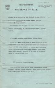 Bendigo Historical Society Inc.
Document - H. A. & S. R. WILKINSOM COLLECTION: CONTRACT OF SALE
Contract of sale dated 28th November between Mr. E. S. Harrison (vendor) and Mr. L. J. Tuena. Solicitor for vendor: E. S. Cahill & son View Street, Bendigo. Solicitor for purchaser: H. E. Every, Dispensatory Walk, Bendigo. Property: 529 Hargreaves Street, Bendigo being land held under right No. 4703 registered in the books of the lands office at Bendigo under land 9residence areas) act 1955 being situated in section 139C Hargreaves Street, Bendigo about 69 links north easterly from Violet Street Bendigo with a frontage of 50 links to Hargreaves Street by a depth of 200 links, together with dwelling house and all improvements, also all blinds, curtains, floor coverings and electric light fittings and shades and gas stove. Price: 1,600 pounds. Attached: statement pursuant to section 34 and engagement or appointment in writing pursuant to section 33 of the estate agents act, 1956.organization, business, h.a. & s.r wilkinson real estate -
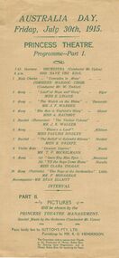 Bendigo Historical Society Inc.
Document - ROYAL PRINCESS THEATRE COLLECTION: AUSTRALIA DAY 1915 PROGRAMME, 30 July 1915
Princess Theatre, Australia Day, Friday, July 30th, 1915. Programme - Part 1. 'Comrades in Arms', Combined Masonic Choir. Land of hope and Glory, Miss E Linane. The Watch on the Rhine, Mr J F Warren. The Sea is England's Glory, Miss A Macoboy. The Yankee Colonel, Mr J K Wlker. There's a Land, Miss Pauline Bindley. The Ballad of Splendid Silence, Miss E O'Keefe. Concert Caprice, Mr T P Bockelmann. Open Thy Blue Eyes, 'Till the Boys Come Home, Miss Clara Colgan. The Boys of Dardanelles, Mr F Monaghan. Accompanist-Mr Stan Elliot. Part II. Pictures will be shown by the Princess Theatre Management. Special Music by the Orchestra (Conductor Mr Upton). Piano kindly lent by Sutton's PTY LTD. Furnishings by Mr R O Henderson. The Committee wish to express their thanks to the Employees of of Messrs. Bolton Bros. for Printing these Programs, and to Messrs. Bolton Bros. for supplying the Paper.Bolton Brosprogram, music, princess theatre, princess theatre, australia day, july 30th, 1915. programme - part 1. 'comrades in arms', combined masonic choir. land of hope and glory, miss e linane. the watch on the rhine, mr j f warren. the sea is england's glory, miss a macoboy. the yankee colonel, mr j k wlker. there's a land, miss pauline bindley. the ballad of splendid silence, miss e o'keefe. concert caprice, mr t p bockelmann. open thy blue eyes, 'till the boys come home, miss clara colgan. the boys of dardanelles, mr f monaghan. accompanist-mr stan elliot. part ii. pictures will be shown by the princess theatre management. special music by the orchestra (conductor mr upton). piano kindly lent by sutton's pty ltd. furnishings by mr r o henderson. the committee wish to express their thanks to the employees of of messrs. bolton bros. for printing and paper