Showing 11166 items
matching printers-blocks
-
 Bendigo Historical Society Inc.
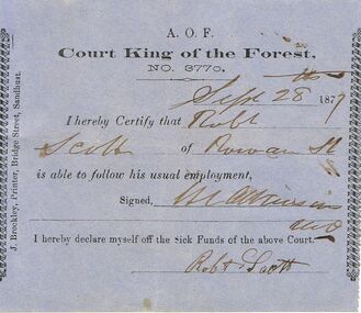
Document - ANCIENT ORDER OF FORESTERS NO 3770 COLLECTION: DOCTOR'S CERTIFICATE
Blue Doctor's Certificate dated Sep 28, 1877, certifying that, Robt. Scott of Rowan St. was able to follow his usual employment. Signed by H. L. Atkinson. Signed at the end by Robt Scott declaring himself off the Sick Funds. Printed by J. Brockley, Printer, Bridge Street, Sandhurst.societies, aof, correspondence, ancient order of foresters no 3770 collection - doctor's certificate, court king of the forest, robt scott, h l atkinson, j brockley -
 Port Melbourne Historical & Preservation Society
Book - Town of Port Melbourne Valuation, 1897
Valuation book, Town of Port Melbourne 1897. Dark French blue cloth (?) cover stamped in gold with title. Tan suede spine and corners, red gold-stamped label on spine. Pages buff. Two page insert pasted into p. 70 being a handwritten letter from valuer detailling 128 houses removed, increase in population, extensions to buildings. (also Rates; assessments)Signed p. 70 by Mayor, Town Clerk and 2 councillors / p71: "Page 72 taken out for printers copy ECC 28/9/98" in purple pencil.local government, built environment, statistics, joseph turner, ad bacis, george samuel walter, n r tarrer, edward c crockford, town clerks -
East Gippsland Family History Group
Ledger Book, Shire of Bairnsdale Wire Netting Fund, 1890
Ledger accounts for wire netting advances made to landholders in the Bairnsdale district by the Shire of Bairnsdale starting in 1890. Lists many names of individuals from the area. Lodged with the East Gippsland Family History Group by the Shire of East Gippsland as part of the Place of Deposit program by the Public Record of Victoria in c2008.Green cloth leather bound indexed ledger 128 folio book recording advances of wire netting to individual landholders and payments under the scheme.LEDGER / WIRE NETTING FUND / SHIRE OF BAIRNSDALE on spine. Inside front cover ARNALL & JAKCSON / Engravers and Lithographers / PRINTERS / AND / MANAUFACTURING STATIONERS, / 478 Collins Street / MELBOURNE / No. -
 Eltham District Historical Society Inc
Slide, Looking south along Bonds Road towards intersection of Montpelier Drive, Lower Plenty, 18 July 1972, 1972
Water drainage work undertaken by Eltham Shire Council in Bonds Road, Lower Plenty outside the Martin property opposite Montpelier Drive, July 1972 Note blocked table drains.35 mm colour positive transparency Mount - Agfacolor Service (Blue)Bonds Road (Martin property) 12.10 pm 18.7.72bonds road, drainage works, eltham shire council, infrastructure, lower plenty, martin property, montpelier drive -
 Phillip Island and District Historical Society Inc.
Photograph, Robert Miller
Robert Miller selected block number 21 Watts Road, Ventnor in 1868 and he and his family came to be among the early settlers oh Phillip Island. See 402-03Large photocopy of portrait of Robert Miller - refer to Family History on 402-03robert miller, early phillip island settlers, watts road ventnor, lynette carr -
 Halls Gap & Grampians Historical Society
Photograph - B/W, C 1924-1930
The information on the back of the photo says: "Henham - with pug walls - blue clay brought up in bags from Dickies' - Where Henham block joined Dickies. Was salt in the area it came from."Photo shows three boys standing in front of a small building (tea-rooms at Henham). There is a large tree (only trunk showing) in the foreground.buildings, tea rooms -
 Eltham District Historical Society Inc
Photograph, Margaret Ball, Jock Read outside home, 54 Henry Street, Eltham, c.Anzac Day 2000, 25 Apr 2000
The adjoining block at no. 52 was not developed at the time. Since Feb 2014 (most recent Google Street View as of Jan 2018), both sites have been bulldozed and new developments built.The Margaret Ball (Pre 1960s Houses) Collection was a personal project initiated to mark the year 2000 and arose as a result of the disappearance of many pre-1960s parts of Eltham due to development. Approximately 200 pre-1960s style houses that were left in Eltham between Main Road and east to Bible Street, between Cecil Street to the north and south to Dalton Street were photographed in late 1999. Not all of the houses could be photographed; some because the garden or trees blocked the view of the house, others because of rubbish or cars were in the way, some because people were working on the house or in the gardens at the time.Colour photographic printeltham, houses, streets, margaret ball (pre 1960s houses) collection, henry street, jock read, lofty (horse) -
 Eltham District Historical Society Inc
Photograph, Margaret Ball, Shillinglaw trees, site of former Shire of Eltham offices and prior to that the original site for Shillinglaw Cottage, 895 Main Road, Eltham, 1999, 1999
The adjoining block at no. 52 was not developed at the time. Since Feb 2014 (most recent Google Street View as of Jan 2018), both sites have been bulldozed and new developments built.The Margaret Ball (Pre 1960s Houses) Collection was a personal project initiated to mark the year 2000 and arose as a result of the disappearance of many pre-1960s parts of Eltham due to development. Approximately 200 pre-1960s style houses that were left in Eltham between Main Road and east to Bible Street, between Cecil Street to the north and south to Dalton Street were photographed in late 1999. Not all of the houses could be photographed; some because the garden or trees blocked the view of the house, others because of rubbish or cars were in the way, some because people were working on the house or in the gardens at the time.Colour photographic printeltham, houses, streets, margaret ball (pre 1960s houses) collection, shillinglaw trees, shillinglaw cottage, eltham shire office -
 Federation University Historical Collection
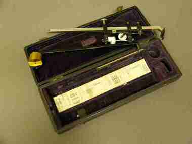
Equipment - Scientific Instruments, Flash-Point Tester, 1898, 1898
Probably used in the Ballarat School of Mines Chemisry Laboratories, at that time led by Professor Alfred Mica Smith, with lecturer Daniel Walker. From W. Watson & Sons, Block Arcade, MelbourneAn early model of a flashpoint apparatus, of mainly brass construction, heated by a spirit lamp. Complete with two mercury-in-glass tfermometers (50 degree to 70 degrees celcius x 1 degree, 10 degrees to 50 degrees celcius c 1 degree), and lamp-stand. Serial Number 1786.scientific instruments, chemistry, alfred mica smith, daniel walker, ballarat school of mines, w. watson & sons ltd, thermometer -
 Geoffrey Kaye Museum of Anaesthetic History
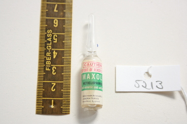
Metaclopramide (Maxolon), 1972
Metoclopramide blocks dopamine receptors in the brain in the areas responsible for the vomiting reflex. It is still used to treat nausea and vomiting that occurs post-operatively or from chemotherapy but there are more effective agents now.Clear glass ampoule with adhered green and white manufacturer's label containing Maxolon.anti-emetic, anti-nauseant -
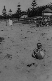 Torquay and District Historical Society
Photograph (copy)
shows small child with a blow up beach ball playing in the sand. location Cosy Corner, Torquay front beach, young Norfolk Pine trees, rotunda and old toilet block.black and white photo, rectangular.torquay beach, rotunda, norfolk pines -
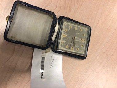 Vision Australia
Functional object - Object, Swiss, Blue travel clock
A silver, square clock with words"1MHOF swiss". Raised, golden dots indicate time blocks. Stored in a blue box, this travel clock could be propped up when the case was opened. Metal clock housed inside blue travel case1MHofassistive devices, swiss -
 Kew Historical Society Inc
Plan, Melbourne & Metropolitan Board of Works : Borough of Kew : Detail Plan No.1291, 1905
The Melbourne and Metropolitan Board of Works (MMBW) plans were produced from the 1890s to the 1950s. They were crucial to the design and development of Melbourne's sewerage and drainage system. The plans, at a scale of 40 feet to 1 inch (1:480), provide a detailed historical record of Melbourne streetscapes and environmental features. Each plan covers one or two street blocks (roughly six streets), showing details of buildings, including garden layouts and ownership boundaries, and features such as laneways, drains, bridges, parks, municipal boundaries and other prominent landmarks as they existed at the time each plan was produced. (Source: State Library of Victoria). This plan forms part of a large group of MMBW plans and maps that was donated to the Society by the Mr Poulter, City Engineer of the City of Kew in 1989. Within this collection, thirty-five hand-coloured plans, backed with linen, are of statewide significance as they include annotations that provide details of construction materials used in buildings in the first decade of the 20th century as well as additional information about land ownership and usage. The copies in the Public Record Office Victoria and the State Library of Victoria are monochrome versions which do not denote building materials so that the maps in this collection are invaluable and unique tools for researchers and heritage consultants. A number of the plans are not held in the collection of the State Library of Victoria so they have the additional attribute of rarity.Original survey plan, issued by the MMBW to a contractor with responsibility for constructing sewers in the area identified on the plan within the Borough of Kew. The plan was at some stage hand-coloured, possibly by the contractor, but more likely by officers working in the Engineering Department of the Borough and later Town, then City of Kew. The hand-coloured sections of buildings on the plan were used to denote masonry or brick constructions (pink), weatherboard constructions (yellow), and public buildings (grey). A detail plan of part of Studley Park bordered by the major streets of Hodgson Street, Stevenson Street and Studley Park Road. Included on the plan are a number of significant Studley Park mansions in existence at the beginning of the 20th century. The unnamed street shown in the middle of the plan is McEvoy Street. The most important house still extant is Campion House, formerly named Dalsraith [Dalswraith] and Glendalough, owned since the 1940s by the Society of Jesus. Campion House can be seen on the corner of Hodgson and Studley Park Road. Its stables at the rear of the block have now been incorporated into a contemporary residence. An interesting feature of the plan is the 1910 annotation by Ed Seitz, professional designing engineer. Is Seitz the contractor who modified the MMBW original?melbourne and metropolitan board of works, detail plans, mmbw 1291, cartography -
 Kew Historical Society Inc
Plan, Melbourne & Metropolitan Board of Works : Borough of Kew : Detail Plan No.1564, 1905
The Melbourne and Metropolitan Board of Works (MMBW) plans were produced from the 1890s to the 1950s. They were crucial to the design and development of Melbourne's sewerage and drainage system. The plans, at a scale of 40 feet to 1 inch (1:480), provide a detailed historical record of Melbourne streetscapes and environmental features. Each plan covers one or two street blocks (roughly six streets), showing details of buildings, including garden layouts and ownership boundaries, and features such as laneways, drains, bridges, parks, municipal boundaries and other prominent landmarks as they existed at the time each plan was produced. (Source: State Library of Victoria)This plan forms part of a large group of MMBW plans and maps that was donated to the Society by the Mr Poulter, City Engineer of the City of Kew in 1989. Within this collection, thirty-five hand-coloured plans, backed with linen, are of statewide significance as they include annotations that provide details of construction materials used in buildings in the first decade of the 20th century as well as additional information about land ownership and usage. The copies in the Public Record Office Victoria and the State Library of Victoria are monochrome versions which do not denote building materials so that the maps in this collection are invaluable and unique tools for researchers and heritage consultants. A number of the plans are not held in the collection of the State Library of Victoria so they have the additional attribute of rarity.Original survey plan, issued by the MMBW to a contractor with responsibility for constructing sewers in the area identified on the plan within the Borough of Kew. The plan was at some stage hand-coloured, possibly by the contractor, but more likely by officers working in the Engineering Department of the Borough and later Town, then City of Kew. The hand-coloured sections of buildings on the plan were used to denote masonry or brick constructions (pink), weatherboard constructions (yellow), and public buildings (grey). In 1905, when Plan No.1564 was printed, that part of Kew bordered by Brougham Place (now Daniell Place), Mount Street, Sackville Street and Ross Street was already the location of a number of large mansions. Here, subdivisions, at least at this stage, produced larger blocks than in Central Kew. Many of the houses on this plan are named: ‘Faybrook’, ‘Northumbria’, ‘Parkholm[e]’, ‘Dunboe’, ‘Katoomba’ and ‘Eschol’ fronting Sackville Street. Eschol was once the home of the manufacturer Robert Harrison, whose cordial factory in Spring and Argyle Streets Fitzroy are noted on the Victorian Heritage Register. ‘The Hawthorns’ on the corner of Brougham Place and Mount Street was the home of the medical practitioner Frank William Fay, who won the military cross and other honours for conspicuous gallantry and devotion to duty in World War 1.melbourne and metropolitan board of works, detail plans, mmbw 1564, cartography -
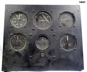 Bendigo Military Museum
Equipment - INSTRUMENT PANEL RAAF, Early WW2
Belonged to Maxwell Lennox Matheson 418447 RAAF. Refer 1959 for his service history.Wood frame block with six (6) instruments, round shape set in the wood frame. The 6 instruments all different all represent a replica of a standard "sperry flight instrument panel". These parts were fitted to most RAF and RAAF aircraft. "M Matheson 87 Reservoir Road Strathdale Bendigo" (Label on rear).instruments, equipment, raaf -
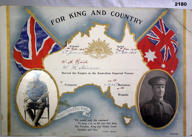 Bendigo Military Museum
Certificate - CERTIFICATE WW1, J Jenkin, Buxton & Co / Rialto, c.1915
For King and Country certificate - Australian Commonwealth Military Forces. Enlisted / sailed / served the Empire in the Australian Imperial Forces / Company / Battalion / Brigade. God Save The King. Verse by CHC Montrose.Cardboard rectangle with map of Australia in gold print, 2 red, blue, white flags. Oval cutouts with block & white photographs of 2 individual soldiers in uniform inserted, black print verse. Rising Sun badge depicted in gold print.“1st Nov 1916 / 16th Dec 1916 / W A Reid / 14th / 4th”, handwritten in red ink. “5th June 1915 / 8th Nov 1915 / W Robinson / 21st & 59th”, handwritten in blue ink.documents - certificates, military history -
Glenelg Shire Council Cultural Collection
Plan - Ship Plan / Mould, n.d
Wooden pattern for mould for boat fitting. Boomerang shaped flat base, strip of ply wood attached at right angles to base, with copper nails, shaped block attached to underside of base with copper nails. Top painted cream, underside unpainted. -
 Halls Gap & Grampians Historical Society
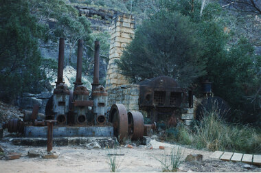
Photograph - Coloured, C 1960s
Photo shows steam boiler equipment. Three iron chimneys appear to the left of the photo. A stone chimney stands in middle of photo nand to back of equipment. A second boiler is encased by stone blocks. A section of boardwalk appears in right front of photo.quarrying, heatherlie -
 Federation University Historical Collection
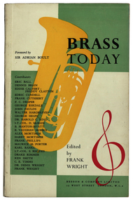
Book, Bessen * Co. Ltd, Brass Today edited by Frank Wright, 1957
Soft covered book with yellow trumpet and red treble clef on green and white block background on front cover, with black titles, 126 pages. Back cover white and blank except for red printing on right hand side bottom corner"F.W." on title page in black ink at top right hand corner.wright, brass instrument, music, besson & company, boult, ball, brain, calvert, clayton, cundell, cuthbert, draper, eskdale, faulds, hargreaves, hespe, hind, mcbain, manton-myatt, morris, mortimer, phillips, porter, rankl, rhodes, rimmer, smith, timms -
 Bendigo Historical Society Inc.
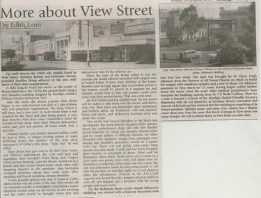
Newspaper - JENNY FOLEY COLLECTION: MORE ABOUT VIEW STREET
Bendigo Weekly from Friday 10, August 2001. More about View Street by Edith Lunn. The second article by Edith Lunn on the small businesses on View street, this one concentrating on the block between Rowan and McKenzie Streets. The clip is in a folder.newspaper, bendigo, bendigo weekly -
 Port Melbourne Historical & Preservation Society
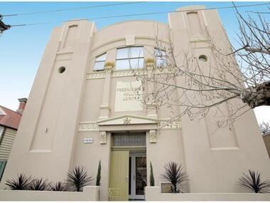
Photograph - Former Freemason's Lodge Building, Liardet Street, Port Melbourne, 1917
The Sandridge Marine Lodge was founded in 1858. Two locations; originally Stokes St and then in Liardet St from 1917. Both buildings are now converted to apartments. .05 - Photo of 2nd Marine Lodge (Freemasons) converted to apartment block in early 2000sbuilt environment - civic, built environment - domestic, societies clubs unions and other organisations, built environment - industrial, freemasons lodge, swallow & ariell ltd, sandridge marine lodge -
The Ed Muirhead Physics Museum
Photograph,Optical Munitions, Glass preparation
Part of a series entitled “Optical Munitions - School of Natural Philosophy, 1942-1945”. Black and white photo of hands operating glass cutter, producing rectangular strips in preparation for experimental fusing of glass “sandwiches” into optical blocks. Same photo as 265In ink on lower left hand corner : “24”. -
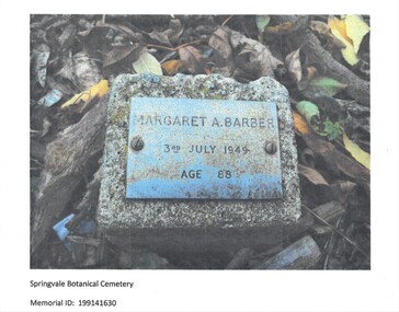 Bendigo Historical Society Inc.
Photograph - MAGGIE BARBER COLLECTION: PHOTO COPY OF A PHOTOGRAPH, 1949
Photograph -copy of a coloured photograph of the gravestone of Margaret A Barber, dated 3rd JULY 1949, AGE 88. What appears to be a marble rectangular plaque, attached to a granite rectangular block, at ground level, surrounded by leaves and bark, in the Springvale Botanical Cemetery.Springvale Botanical Cemetery Memorial I.D: 199141630.photograph, streetscape, springvale botanical memorial cemetery -
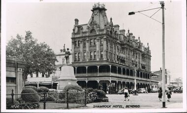 Bendigo Historical Society Inc.
Photograph - BENDIGO - SHAMROCK HOTEL
Photograph - black and white. Photo of Shamrock Hotel, Bendigo, war statue in centre. (number written on left hand side No.24). Soldier memorial left of centre. Iron fence surrounds lawn and shrubbery, old toilet block extreme left.buildings, hotel, shamrock hotel., shamrock hotel, bendigo. -
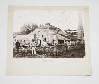 Buninyong & District Historical Society
Photograph - B/W photograph, Buninyong Brewery c 1870, c1870
Photograph of an early family, the Sheppards, by their early industrial building, the brewery, in Buninyong, c1870.Significant example of early Buninyong industry, original bluestone building.Mounted B/W photograph of Buninyong Brewery c1870. Bluestone block, brick and timber building with tall round brick chimney nearby. Sheppard family in front of brewery, depicted M,M,M,F,M, with good clothing detail.buninyong brewery, brewery, buninyong, industry, building -
 Whitehorse Historical Society Inc.
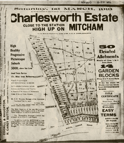
Document, Charlesworth Estate, 1913
Charlesworth Estate, Mitcham. 50 elevated allotments, 1/2 to 1 acre each and 14 garden blocks from 2 to 7 acres each. 1 March 1913.Brochure for auction of Charlesworth Estate, Mitcham. 50 elevated allotments, 1/2 to 1 acre each and 14 garden blocks from 2 to 7 acres each. 1 March 1913. Agents: Coghill & Houghton and H. Carey Sutton.Charlesworth Estate, Mitcham. 50 elevated allotments, 1/2 to 1 acre each and 14 garden blocks from 2 to 7 acres each. 1 March 1913.auctions, charlesworth estate, mitcham, quarry road, doncaster east road, burnett street, harrison street, whitehorse road -
Whitehorse Historical Society Inc.
Map, Dandenong Ranges area. Sheet 7, c1957
Detailed map covering area from Mitcham and Vermont to Ringwood and Heathmont.Detailed map covering area from Mitcham and Vermont to Ringwood and Heathmont. Shows streets, block boundaries, buildings, railway and creeks. Note says prepared from State Aerial Survey, April 1954 and Cadastrial Survey information July 1956.Detailed map covering area from Mitcham and Vermont to Ringwood and Heathmont. maps, mitcham, vermont, ringwood, heathmont -
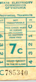 Ballarat Tramway Museum
Ephemera - Ticket/s, State Electricity Commission of Victoria (SECV), SEC 7c & 8c tram, late 1960's
SEC 7c & 8c tram tickets, paper flimsy ex blocks 527.1 - 7c C785340 - light blue print, black numbers. 527.2 - 8c A830312 - light green print, black numbers See attached sheet for further information.trams, tramways, tickets, ballarat -
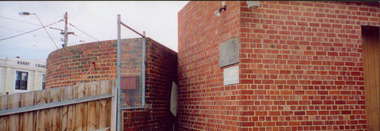 Kew Historical Society Inc
Photograph - Former Kew Court House : rear buildings facing Cotham Road, 1996
A civic campaign for new public offices developed in Kew in the 1880s. After much deliberation, the location chosen was the junction of Bulleen and Cotham Roads. The buildings were designed by George Watson and John Henry Harvey, architects within the Department of Public Works (Victoria). Building was commenced in 1887, and after one year, the buildings were opened. The Post Office was transferred to the new Commonwealth Government in 1901. The Police Station and Court House, sold by the Victorian Government to the City of Boroondara in 2007, are now a community cultural centre and performing arts venue.The buildings were listed on the Victorian Heritage Register Register (HO885) in 1991. They are historically and architecturally significant to the State of Victoria because Watson and Harvey's designs exhibit diversity in integrating civil offices, they accommodate the apex of road junctions, and they demonstrate a departure from the contemporaneously favoured High Victorian Classical to the Queen Anne style in the design of civic buildings.Original print positive photograph of two buildings on Cotham Road at the rear of the Kew Court House. On the left is a red brick public toilet block, designed by Roland Chipperfield. On the right is a red brick garage; a later addition to the Court House complex.kew court house, public offices -- kew (vic), public toilet -- kew (vic.), kew police station -
Maldon Vintage Machinery Museum Inc
PRINT-TYPE CABINET, MENS SHED
Wooden cabinet for holding print type. Made of pine with pale grey/white laminated top. Contains 16 trays in two blocks of 8 for storing metal type. Each tray is divided into sections Trays are wooden with some painted on front .trades; printing; woodwork; handcrafts; carpentry