Showing 7536 items
matching kew
-
 Kew Historical Society Inc
Book, Dorothy Rogers, A History of Kew, 1973
xvi,256p. : maps on lining papers, plates, tables ; 24cm. non-fictionkew (vic.) -- history., melbourne -- kew 1840-1972 -
Kew Historical Society Inc
Book, Dorothy Rogers, A History of Kew, 1973
xvi ,256p. : maps on lining papers, plates, tables ; 24cm. non-fictionkew (vic.) -- history., melbourne -- kew 1840-1972 -
Kew Historical Society Inc
Book, Brief History 1925-1975, East Kew Presbyterian Church, 1970
non-fictionchurches -- kew (vic.), presbyterian church -- kew (vic.), east kew presbyterian church -
Kew Historical Society Inc
Book, Arnall & Jackson: Printers & Stationers, City of Kew, 1928
non-fictioncity of kew (vic.) -
Kew Historical Society Inc
Book, Travers Morgan Pty Ltd, City of Kew, 1990
non-fictioncity of kew (vic.) -
Kew Historical Society Inc
Book, Arnall & Jackson: Printers & Stationers, City of Kew, 1929
non-fictioncity of kew -
Kew Historical Society Inc
Book, City of Kew ACTION REQUEST Form Book
city of kew -
Kew Historical Society Inc
Book, Travers Morgan Pty Ltd, City of Kew Open Space Strategy, 1990
non-fictioncity of kew -
Kew Historical Society Inc
Book, Pru Sanderson Design Pty Ltd, City of Kew Urban Conservation Study Volume 1, 1988
non-fictionconservation reports -- kew (vic.) -- 1988 -
Kew Historical Society Inc
Book, Pru Sanderson Design Pty Ltd, City of Kew Urban Conservation Study Volume 2, 1988
non-fictionconservation reports -- kew (vic.) -- 1988 -
Kew Historical Society Inc
Book, Pru Sanderson Design Pty Ltd, City of Kew Urban Conservation Study Volume 4, 1988
non-fictionconservation reports -- kew (vic.) -- 1988 -
 Kew Historical Society Inc
Book, Dorothy Rogers, Lovely Old Homes of Kew, 1961
History of "Fairyland" Cottage. A personalised, signed copy of the History of Fairyland Cottage wrapped as a birthday gift.[Melbourne, 1961] 44 p. illus. 22 cm. non-fictionHistory of "Fairyland" Cottage. A personalised, signed copy of the History of Fairyland Cottage wrapped as a birthday gift. lovely old homes of kew, dorothy rogers -
Kew Historical Society Inc
Book, Brian Carroll, Hawthorn and Kew Sketchbook, 1975
Adelaide : Rigby, 1975 62p. : ill. ; 23cm. non-fictionbuildings of historical importance -- melbourne -- hawthorn & kew, hawthorn (vic.) -- buildings & structures & etc, kew (vic.) -- buildings & structures & etc. -
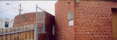 Kew Historical Society Inc
Photograph - Former Kew Court House : rear buildings facing Cotham Road, 1996
A civic campaign for new public offices developed in Kew in the 1880s. After much deliberation, the location chosen was the junction of Bulleen and Cotham Roads. The buildings were designed by George Watson and John Henry Harvey, architects within the Department of Public Works (Victoria). Building was commenced in 1887, and after one year, the buildings were opened. The Post Office was transferred to the new Commonwealth Government in 1901. The Police Station and Court House, sold by the Victorian Government to the City of Boroondara in 2007, are now a community cultural centre and performing arts venue.The buildings were listed on the Victorian Heritage Register Register (HO885) in 1991. They are historically and architecturally significant to the State of Victoria because Watson and Harvey's designs exhibit diversity in integrating civil offices, they accommodate the apex of road junctions, and they demonstrate a departure from the contemporaneously favoured High Victorian Classical to the Queen Anne style in the design of civic buildings.Original print positive photograph of two buildings on Cotham Road at the rear of the Kew Court House. On the left is a red brick public toilet block, designed by Roland Chipperfield. On the right is a red brick garage; a later addition to the Court House complex.kew court house, public offices -- kew (vic), public toilet -- kew (vic.), kew police station -
 Kew Historical Society Inc
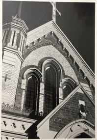
Photograph, Congregational Church, Walpole Street, 1977
The Congregational Church was built on the site of the first church in Kew. This church, the second on the site, was designed by the Kew architect Charles Vickers and opened in 1860. The distinctive polychrome brick façade designed by Vickers contrasted with the style that he employed for other churches he designed during this period; they were usually constructed in bluestone. In the 1960s, a new ministry saw the erection of a neon cross at the apex of the church. The illuminated cross could be seen from Church Street, Hawthorn. The church was later to be demolished, and the land sold for the construction of modern villas.Congregational Church, Walpole Street, Kew, 1977 (now demolished). View of the polychrome facade facing Walpole Street. The use of polychrome brick by Alfred Purchas (the second architect) reflects his preference for this architectural style, such as in his design for Tarring (now Ruyton Girls' School) Inscriptions on reverse: "K.H.701. Congregational Church Walpole St Kew. First church in Kew. Now amalgamated with the United Churches."congregational church, walpole street (kew), charles vickers -
 Melbourne Legacy
Photograph, Harelands, 9/9/1963
The Harelands property in Kew, was used as a residence for Junior Legatees (Legacy Beneficaries) up to the age of 14 years. It operated during the 1960’s and 1970’s.Melbourne Legacy established residences to aid children of deceased servicemen complete their education, take further education and find employment.Black and white photo of Harelands, Willsmere Road, Kew. Handwritten 'Harelands 1963 Willsmere Road, Kew up to 14 year-olds Residence for Junior Legatees'. Stamped 'Property of Melbourne Legacy' in purple ink. Stamped with photographers details and order number (P2976/7) and date (9/9/63).harelands, residences, properties -
 Kew Historical Society Inc
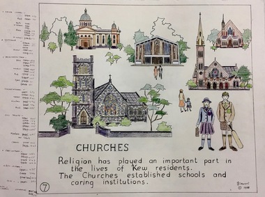
Work on paper, Joy Stewart, 7. Churches, 1988
Kew Tapestry The eight panels depict the history of Kew. This was a 1988 Australian Bi-Centennial Project carried out under the auspices of City of Kew Council and the Kew Historical Society Incorporated. Nearly 600 citizens including many children participated in the production by adding a few or more stitches. A book records their names and the panels upon which they worked. Artist: Joy Stewart Co-ordinator: Dorothy BenyeiSydney Joy (Joy) Stewart was born in Melbourne 1925. She studied at Swinburne Technical College Art School from 1941-1945, then the National Gallery Art School 1946-1948. Her career included employment positions as a display artist, designer/painter, gallery assistant, and art teacher. Joy relocated to Cairns in 1981. Solo exhibitions in Melbourne and Cairns, including 'Done By Me' at Cairns Regional Gallery in 1999. Group exhibitions at Cairns Regional Gallery, 'The Fish John West Regrets, 1993' and 'Facets of Life' 1994. Joy Stewart died in Cairns in 2018.7. Churches. A Handcoloured cartoon created by the artist Joy Stewart as a template for the seventh of a series of embroidered panels depicting the history of Kew. Wool colour codes at left. Inscription: "CHURCHES. Religion has played an important part in the lives of Kew residents. The churches established schools and caring institutions." Signed by the artist "(c) JStewart, 1988"bicentennial project (kew), joy stewart -
 Kew Historical Society Inc
Photograph - Kew Junction, Herald & Weekly Times, 1962
This is an aerial oblique image looking north. It shows Kew Junction before construction of VicRoads (Country Roads Board), Murphy's (Leo's) supermarket, and office towers. It also shows a building on the land now known as the Raoul Wallenberg Reserve, the Kew Municipal Offices in Walpole Street, and St Paul's School for the Blind in Fernhurst Grove, and Kew Bowling Club in Wellington Street.An aerial photograph of Kew Junction, showing the intersection of High Street South, Studley Park Road, Princess Street, High Street and Denmark Street. A number of buildings, now demolished can be identified in the photo, including Jellis’ Bakeries on the corner of Princess Street and Studley Park Road." Annotation on reverse: "Kew Historical Society from Mr L. H. Chinner".kew junction, aerial photograph (kew), oblique aerial, st paul's school for the blind, kew municipal offices, high street kew, studley park road, kew war memorial, kew post office, kew police station, kew court house, high street south, kew, wellington street kew, denmark street kew -
 Kew Historical Society Inc
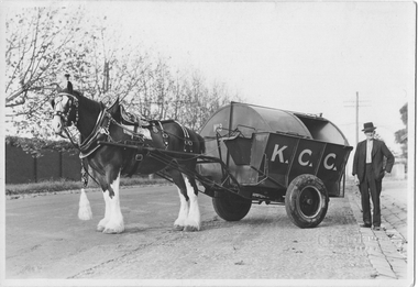
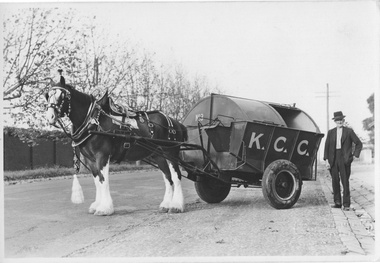
Photograph - City of Kew Horse, Cart and Employee, Stuart Tompkins, c.1950
The Kew City Council Depot was for a period situated on the corner of High Street and Disraeli Streets. The photo from the former City of Kew Municipal Collection was taken by a photographer from Stuart Tompkins Studio in Camberwell.One of four black and white photographs (perhaps reproductions) of a horse and cart and a council employee in Parkhill Road, Kew. In a number of photos the cart has K.C.C., in large letters on its side. It is presumed to be the city garbage cart No.3 which was stationed at the old Council Depot on the corner of High and Disraeli Streets. "Cr Parkhill Rd & Hillcrest Ave Kew / Driver : Barry Avery"city of kew, garbage waste collection - kew (vic), barry avery, kew depot, stuart tompkins -
![7 Roomed Brick [villa]; Modern Conveniences](/media/collectors/550653872162f11fb04854aa/items/59ec3da221ea690fdc4ba793/item-media/59ec3ee521ea690fdc4d0c37/item-fit-380x285.jpg) Kew Historical Society Inc
Kew Historical Society IncPhotograph - 7 Roomed Brick [villa]; Modern Conveniences, 1920s
The Kew Historical Society's map collection includes a substantial number of real estate subdivision plans, mainly of Kew but also of surrounding suburbs in Melbourne. Most of the subdivision plans date from the 1920s and 1930s when the districts old homes and local farmland were being split up to accommodate residential growth in the postwar period. These early plans were assembled by a local firm, Jas R Mather & McMillan, which had an office in Cotham Road. Many of the plans, and sometimes photos, were annotated by the agents.Subdivision plans are historically important documents used as evidence for the growth of suburbs in Australia. They frequently provide information about when the land was sold as well as evidence relating to surveyors and real estate and financial agents. The numerous subdivision plans in the Kew Historical Society's collection represent working documents, ranging from the initial sketches made in planning a subdivision to printed plans on which auctioneers or agents listed the prices for which individual lots were sold. In a number of cases, the reverse of a subdivision plan in the collection includes a photograph of a house that was also for sale by the agent. These photographs provide significant heritage information relating house design and decoration, fencing and household gardens.The photograph may also be aesthetically significant depending on the importance of the photographic atelier.A professionally produced photograph for a local real estate agent, probably Jas. R. Mathers, Son & McMillan. The photograph is of a Federation-era bungalow, in Kew. The photo is on the reverse of a subdivision plan for the Normanby Heights Estate, Kew.The mount on which the photograph is placed includes: "Kew. 1 minute to tram. Good Position. / 7 roomed brick. Modern conveniences. / Land 60 x 135. 1100 pounds"real estate photographs, houses - kew, federation architecture -
 Melbourne Tram Museum
Document - Memorandum, Kew Depot, "Issues concerning and relating to the New Shunt being Constructed in Spencer Street", 18/11/1993 12:00:00 AM
Memorandum - two A4 sheets - titled "Issues concerning and relating to the New Shunt being Constructed in Spencer Street" from Ric Barker, Secretary Kew Tram Depot Committee to Frank Barbuto, Acting Depot Manager - 18-11-1993. Regards issues of the single line shunt in Spencer St, north of Latrobe St, Safety Zones, timing, running times, solutions and options.trams, tramways, spencer st, terminus, la trobe st, safety zone -
Melbourne Tram Museum
Document, Hugh Waldron, "History of Kew Depot", 21/6/2024
Digital document - "History of Kew Depot" by Hugh Waldron from the establishment of tramways in the area including steam tramways, horse tramways, background history to tramways, cable trams, building of the depot by the PMTT in 1915, operation by the MMTB, events, people, incidents, through to July 2017. Includes a bio of the author on page 54. Updated to 21/6/2024.Yields information about the history of Kew Depot and its relationship with Melbourne tramways.Digital document - 54 A4 pagestramways, crews, depots, kew depot, history, hugh waldron -
 Ballarat Heritage Services
Photograph - Colour, Kathleen Gervasoni, Birthday Party, c1972, c1972
Colour photograph of Ann Gervasoni's birthday party held at 93 Willsmere Road Kew (behind North Kew Newsagency). Some of the partygoers wear the uniform of St Anne's East Kew. Left to right: Clare Gervasoni, Sally Ann Estella, Ann Gervasoni, Lisa Gervasoni (red jumper), Eve Urban, Genevieve Rayson.birthday, gervasoni, birthday cake, st anne's east kew uniform -
 Kew Historical Society Inc
Photograph - City of Kew Horse, Cart and Employee, Stuart Tompkins, c.1950
The Kew City Council Depot was for a period situated on the corner of High Street and Disraeli Streets. The photo from the former City of Kew Municipal Collection was taken by a photographer from Stuart Tompkins Studio in Camberwell. One of four original black and white photographs of a horse and cart and a council employee, Barry Avery, in Parkhill Road, Kew. In a number of photos the cart has K.C.C., in large letters on its side. It is presumed to be the city garbage cart No.3 which was stationed at the old Council Depot on the corner of High and Disraeli Streets. "Cr Parkhill Rd & Hillcrest Ave, Kew / Driver: Barry Avery"city of kew, garbage waste collection - kew (vic), stuart tompkins, barry avery -
 Kew Historical Society Inc
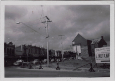
Photograph - Kew Junction during road widening, December 1958
Kew Junction is the intersection of five major roads - Denmark Street, High Street, High Street South, Studley Park Road and Princess Street. The original widening of High Street in the 1930s expanded that street by removing shops on the south side of the street from Cotham Road to Denmark Street. Further widening in 1958 removed shops at the west end of High Street to allow for increased traffic using Princes Street and Denmark Street.Original, black and white positive of Kew Junction, including the corner with Denmark Street during road widening in the 1958.Inscribed verso: "Kew Junction Dec 1958 / When the road was being widened by the removal of a number of shops / Notice saying Retchford's Estate agency's temporary office is at the top end of Denmark Street, Kew"kew junction, denmark street -- kew (vic.), major roadworks -- kew (vic.) -
 Kew Historical Society Inc
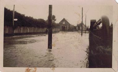
Photograph - Flooded street, 1940-50
View of unknown flooded streetscape.Original, black and white positive of a flooded street, originally believed to have been in Kew, but based on an examination of the history, deemed not to be a location in Kew or Kew East. The flooding is of a T-intersection with a brick church and a house in the background.Inscribed verso: "? Kew / R 774 / VELOX"floods -
 Kew Historical Society Inc
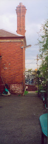
Photograph - Former Kew Police Station : Wall and chimney, 1996
A civic campaign for new public offices developed in Kew in the 1880s. After much deliberation, the location chosen was the junction of Bulleen and Cotham Roads. The buildings were designed by George Watson and John Henry Harvey, architects within the Department of Public Works (Victoria). Building was commenced in 1887, and after one year, the buildings were opened. The Post Office was transferred to the new Commonwealth Government in 1901. The Police Station and Court House, sold by the Victorian Government to the City of Boroondara in 2007, are now a community cultural centre and performing arts venue.The buildings were listed on the Victorian Heritage Register Register (HO885) in 1991. They are historically and architecturally significant to the State of Victoria because Watson and Harvey's designs exhibit diversity in integrating civil offices, they accommodate the apex of road junctions, and they demonstrate a departure from the contemporaneously favoured High Victorian Classical to the Queen Anne style in the design of civic buildings.View through the Cotham Road carpark towards High Street of the southeast corner of the former police station. The use of red brick, tall brick chimneys and slate roof were representative of the Queen Ann Style used in the construction of the Kew Public Offices in 1888.public offices -- kew (vic), kew police station -
 Kew Historical Society Inc
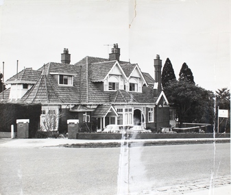
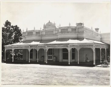
Photograph - 'Wimba', Cotham Road, J E & B L Rogers, c.1965
'Wimba' is of significance as one of the key nineteenth century houses of Kew and for remaining in a substantially intact state. Although probably built some time earlier, the first mention in the Rate Books of the property later known as 'Wimba Lodge' appears in the entry for 1870 when the property, owned by John Sharpe Denbigh, a civil servant, was given an N.A.V. of £72 2. Denbigh did however occupy a house in Cotham Road in 1863, and it is possible that was the same premises'. The house was occupied by Denbigh until at least May 1876 when the 'family residence...' \ 'as auctioned to Carlington George Edmund Marston 5, a chemist of Smith Street, Collingwood. At the time of the auction the house was described thus: The residence and grounds of the late J.S. Dendigh, situate in the most elevated part of Cotham Road Kew. The grounds comprise an area of 4a Or29p or thereabouts, and have a frontage to Cotham-road of 4 chains. The house has two large rooms in front, with 6ft hall built of brick, bay and side windows (plate glass), four rooms of wood behind with slate roofs, bathroom and closets, detached kitchen and servant's room, large shed with washing boiler, pantry and cellar under, brick and cement tank, and the Yan Yean laid onto house and grounds, cowshed, pigstye, &c, the whole securely fenced. First class orchard and flower garden. The paddocks laid with English grasses and drained... .' (Sanderson P, City of Kew Urban Conservation Study, Volume 2, 1988)This work forms part of the collection assembled by the historian Dorothy Rogers, that was donated to the Kew Historical Society by her son John Rogers in 2015. The manuscripts, photographs, maps, and documents were sourced by her from both family and local collections or produced as references for her print publications. Many were directly used by Rogers in writing ‘Lovely Old Homes of Kew’ (1961) and 'A History of Kew' (1973), or the numerous articles on local history that she produced for suburban newspapers. Most of the photographs in the collection include detailed annotations in her hand. The Rogers Collection provides a comprehensive insight into the working habits of a historian in the 1960s and 1970s. Together it forms the largest privately-donated collection within the archives of the Kew Historical Society.The front entrance of Wimba in Cotham Road, Kew. The entrance is flanked by two polygonal bay windows, and a verandah with a concave corrugated iron roof returns around three facades, and accentuates the projections of the windows. The solid render parapet is very ornate and tall for the date of construction. It has panels of decoration along it and is surmounted by a number of render urns. The image was used by Dorothy Rogers in 'A History of Kew' (1973), facing page 144.Wimba ca. 1860 built by J.S. Denbigh (has been altered).wimba, kew, dorothy rogers -
 Kew Historical Society Inc
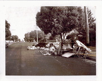
Photograph - Hard rubbish in the City of Kew, c.1980
One of eight photographs donated by the City Engineer of the former City of Kew, mostly of hard rubbish clearance during the period 1969-1985.One of a dated series of photographs of core local government services as practised by the City of Kew in the period 1969-1985. Original black and white photographic positive of hard rubbish awaiting collection in a street within the borders of the City of Kew.Stamp - K90K652 / In envelope marked: "Kew City Council / 12 photos / 1969 1979 18980 1985 / Unburnable rubbish units 18/1/80"garbage, hard rubbish, garbage removal, city of kew, local government -- city of kew, household waste, hard waste -
 Kew Historical Society Inc
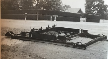
Photograph - Street Works, Studley Park Road, March 1934
Studley Park Road, like most streets in Kew, was originally a dirt road. Street works during the Great Depression included bituminising major roads in the district. This photograph of Council works originated in the City of Kew Engineers Department as a record of works undertaken. It was given to the collection by a Mrs Fisher in 1998.Well provenanced photograph of Council-funded public works in Kew during the Great Depression. Original sepia photographic positive of a drag used to spread bitumen in Studley Park Road, Kew.Typed reverse: "B4 / Kew C.C. / Drag spreader used for premixed material on Studley Park Road, showing end of strip just with spread, with unsurfaced work on left and completed section on right, March 1934"roadworks -- kew (vic.), street works -- kew (vic.), public works kew (vic.), studley park road -- kew (vic.), city of kew -- engineers department, city of kew -- public works -- great depression -- 1930s