Showing 3765 items
matching surveyed
-
 Flagstaff Hill Maritime Museum and Village
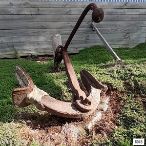
Equipment - Anchor, John Trotman, 1852 to early 1900s
This Trotman’s pattern stock anchor is the southernmost anchor on display at Flagstaff Hill’s Anchor Graveyard. This large Trotman design anchor was patented in 1852 by John Trotman and was widely used on merchant ships. On April 15th 2001 around midday this anchor was raised from the seabed of Lady Bay, Warrnambool, by the crew from Birdon Dredging, who had been hired to dredge the Harbour. The spokesperson Steve Walker, who worked for the firm, said that the anchor and long chain were found after the chain became tangled in the cutter blade of the dredging equipment. The anchor was lifted from the water and onto the Breakwater then a front-end loader placed it onto a truck that then delivered it to Flagstaff Hill Maritime Museum & Village. Howard Nichol, Museum Manager at the time, had estimated the anchor to be up to 130 years old. The previous Museum Manager, Peter Ronald, who was also a diver, had identified the anchor as a Trotman’s type and similar to those used on some of the major wrecks in the region. According to Nicholl, Museum staff believed it was possible that the anchor is one of two used as a mooring line that had been used to catch driving vessels and prevent ships from washing aground on the sand bar. The mooring line was shown as a dotted line on the 1890 chart of Lady Bay, approved by Lieutenant Stanley of the British Admiralty. by Lieutenant Stanley [British Admiralty]. The location of the anchor corresponds to a point on that map and the length of the chain supports that theory. “The map is quite a detailed survey of the Bay and it shows two anchors with buoys on the ends with probably about 100 yards of chain stretched between them. The ships would drop anchor and was the chain as a snag because this was a treacherous bay before the Breakwater was built and this was a way to eliminate that problem, "said Nichol. The mooring chain was put in place to catch drifting vessels during wild stormy weather. It was identified. ABOUT TROTMAN’S ANCHORS- The British Admiralty wanted an anchor design that had more holding power. The Committee of 1852 on Anchors was appointed to assess and report on the qualities of various anchors including Trotman’s anchors. Trotman’s pattern anchor received the highest score. The anchor is similar to the Admiral’s design but features arms that pivot when the anchor settles and the upper fluke moves to rest against the shank. The anchor then sits lower, which in turn greatly reduces the chances of the anchor’s chain, cable or rope getting tangled. The top of the shank has a fitting that allows a quick release of the anchor’s chain if this becomes necessary. This Trotman’s anchor is significant as a part of the maritime history of the Port of Warrnambool regardless of whether it belonged to one of the 29 ships that were stranded or wrecked in Lady Bay. The anchor is connected to the many attempts to maintain Warrnambool as a safe and manageable port, including the various plans for the construction of the Breakwater.Anchor: an iron Trotman’s pattern style with a rectangular-section shank that is wider in the middle and has a base that extends on two opposite sides in a ‘fork prong’ manner. A crescent-shaped, double-ended arm is fitted into the base of the shank with a bolt, enabling it to pivot. Each arm has a fluke in the shape of an upward palm with an attached metal plate that forms a horn at the back of the palm. A long, round-section pipe is fitted to the top of the shank at 90 degrees to the arms; one side has an elbow bend parallel to the arms, and both ends have an attached metal sphere. The pivoting ring at the top of the shank can be lifted for a quick release of the chain.flagstaff hill, warrnambool, maritime village, maritime museum, shipwreck coast, great ocean road, anchor, mooring, trotman, lady bay, breakwater, admiralty, ship equipment, stock anchor, john trotman, 1852 patent, 2001, birdon dredging, steve walker, howard nichol, peter ronald, british admiralty, lieutenant stanley, committee of 1852 on anchors -
 Eltham District Historical Society Inc
Photograph, View looking up 'Policeman's Hill' on Main Road from Dalton Street showing Police Residence, c.1906, 2010c
For original image see EDHS_00533 This photo was originally mounted on 3mm MDF fibre board with notes and stickers applied as part of a display on the former Police Residence and now present day Local History Centre, home to Eltham District Historical Society; possibly put together by Harry Gilham during his time as president of the society. Eltham Police Station and Residence: A brief history 1860 Eltham Courthouse built in Main Road, together with an adjoining police residence, office, lock–up and stables. 1959 Police Department purchases a house in Pryor Street to be refurbished as Eltham Police Station 1961 Police in Eltham move into Pryor Street refurbished buildings and office. c.1961-1981 Occupied by Vermin and Noxious Weeds Destruction Section of the Department of Crown Lands and Survey. Former Police Station dragged around to rear of Police Residence (prior to August 1967) to make way for the construction of a driveway and access from Main Road. The building was placed on the site of a former Scullery and modified for Lands Department use. 1981 Shire of Eltham take over management of old Police Residence in Eltham. It remains unoccupied for a period of time whilst its future is discussed in Council. 1981-1985 Used for community job creation scheme 1985 Shire of Eltham Parks and Environment occupy the residence. Council improve the driveway but later add a second rear access from Brougham Street due to the dangerous nature of the Main Road entrance. Also add a rear toilet facility between the Police Residence and former Police Station, which was doubling up as a lunch room. Council also commence discussions to re-establish a replica Police Station. c.1986 November. Former Police Station demolished; believed to have been suffering termite damage. c.1989 After some years of discussion a replica Police Station is built, based on photographs, to act as a lunch room and meeting room for Parks and Environment staff and volunteers doing community service. 1996 Eltham District Historical Society in discussions with Nillumbik Shire Council commisioners throughout the year regarding a home for the Society. A proposal put forward by the Society in October to occupy the former Police Residence. 1997 March. Eltham District Historical Society gains access to former Police Residence. 1998 July 12th. Eltham District Historical Society Inc moves into its Local History Centre, 728 Main Road Eltham (the former Police Residnce built in 1860). 2018 July. Eltham District Historical Society gains access to the replica Police Station for use as part of regular heritage tours for schools and community based groups.Black and white photocopyLabels and handwriting in pencil and ink identifying various buildings. Also highlighted is the acetylene gas lamp and on reverse is written "Lamplighter Jimm Saville"728 main road, eltham, local history centre, parks and environment, police residence, police station, shire of eltham -
 Melbourne Legacy
Document - Eulogy, Legatee Francis John Doolan
Information on the life of Legatee Frank Doolan from a eulogy in 1988. Legatee Doolan was a very active Legatee, starting within the first year of Legacy when he was nominated by Bill Laver and Charles Copp in 1924. While he never sought 'office but he was always there - in the background - able and willing to actively serve'. In World War 1 he enlisted in November 1917 and served with 1st Division Signal Company and in France. After Armistice he attended a course for young AIF surveyors at the British Ordnance Headquarters at South Hampton designed to bring skills back to Australia. Famously it was Frank that proposed that the spirit of Legacy is service to the widows and children. "Here it received its soul. The thoughts transmitted to the Board by this quiet man." He was Legacy's link to the Big Brother movement that was sponsoring bereft children in England to be sympathetically housed in Australia. He was a foundation member of the the first boys' gymnasium class and of the literary and debating class. He worked with the Intermediate Legacy Club for it's entirety He was part of the Legacy team who worked enthusiastically for the establishment of the Shrine. It was his technical skill as a surveyor that enabled the ray of light to shine on the Stone of Remembrance at 11 am on 11th November. Also to solve the complication of daylight saving in 1976 by positioning two mirrors. For this he was awarded the British Empire Medal. Born in 1896 at Armadale he was educated in Ballarat and South Melbourne. He obtained his qualification as a licensed surveyor at the Working Men's College (now RMIT) in 1919 on returning from war. He was partner in 'Doolan and Goodchild' through the hardships of the Great Depression. Then joined firm of Mendell, Gillespie and Charleman - being supported by Legatee Jim Gillespie. He went on to Lecturer of surveying at the Working Men's College from 1926 to 1938. Then he was assisted by Legatee Alan Murray to a position with the Valuers Section of the Department of Interior. In 1953 he was promoted to be Chief Property Officer for Victoria retiring in 1961. The page from the Bulletin from 18 August 1988 shows the names of many donors that had paid tribute to Frank. A few sentiments were included by some: 'A quiet, loveable and outstanding Legatee.' 'He was my friend, guide and mentor during the 14 happy years I spent in Legacy.' The information was part of an album of past presidents from 1965 to 1989. The folder included biographical details and obituaries, eulogies and death notices of prominent Legatees. The items have been catalogued separately.Part of the collection of material held by Melbourne Legacy on Legatee Frank Doolan a prominent member of Legacy. The information was collected to record the lives of prominent legatees in a folder.Typed A4 document x 2 pages of the life of Legatee Frank Doolan and one page from the Bulletin with donations received in his memory.eulogy, frank doolan, ray of light, shrine of remembrance, ilc, donations -
 Glen Eira Historical Society
Album - Album page, Bureel (Kooyong Road), Circa 1972
This photograph is part of the Caulfield Historical Album 1972. This album was created in approximately 1972 as part of a project by the Caulfield Historical Society to assist in identifying buildings worthy of preservation. The album is related to a Survey the Caulfield Historical Society developed in collaboration with the National Trust of Australia (Victoria) and Caulfield City Council to identify historic buildings within the City of Caulfield that warranted the protection of a National Trust Classification. Principal photographer thought to be Trevor Hart, member of Caulfield Historical Society. Most photographs were taken between 1966-1972 with a small number of photographs being older and from unknown sources. All photographs are black and white except where stated, with 386 photographs over 198 pages. From: Glen Eira Heritage Management Plan 1996 by Andrew Ward In 1856, John Allee, a builder from Brighton, purchased C.A. 37 on the south-west corner of Glenhuntly and Kooyong Roads. The land comprised just over 45 acres. By 1863, Francis John Sidney Stephen, a lawyer and cousin of J. Wilberforce Stephen, owned most of lot 37. By 1866, Stephen had a built a "small mansion" named ''Burreel". It was a brick house and Stephen lived there until 1882. By 1884, Mrs Buxton of Hillside Terrace, East Melbourne, had purchased the property. Richard Buxton, a gentleman was listed as occupant and the house described as "brick, eight rooms". NAV was £300. Richard Buxton continued residency in 1887 however in 1888, George Allen, music seller, became occupant. At that time the house had thirteen rooms on twenty-three acres of land. Twelve people lived there and NAV was £920. In 1900, Daniel Luxton, stock and sharebroker and the Honourable John Taverner, M.H.A. leased the property. Fourteen people lived there. Mrs Buxton continued as owner. By 1910, ownership had passed to Mrs Mary Neate, who converted the house to a nursing home. The land had been subdivided by 1913 and sold by ''Buxtons Estate". Burreel Avenue, Baxter, Buxton and Hoddle Streets were created. "Burreel" was rated to Burreel Avenue and stood on lot 13 with frontages to Burreel Avenue and Kooyong Road of 198' and 214'. The house had ten rooms. NAV was £60. Mary Neate, a nurse, continued as owner/ operator of ''Burreel" nursing home in 1927. At that time there were sixteen rooms and fourteen residents. NAV was £100. Mrs Neat remained there until 1947. In 1948, the house was turned into apartments. In the 1980's, the Alexander family purchased it and restored it to a private residence.Burreel 331 Kooyong Road, ELSTERNWICK VIC 3185 - Property No B4950 National Trust https://vhd.heritagecouncil.vic.gov.au/places/65648 This is a large and substantially intact example of the grand villas of nineteenth century Melbourne. The bulk of the house most probably was built in 1866-1868 for Francis John Sidney Stephen, a prominent and highly regarded Melbourne solicitor and a member of an illustrious legal family. Stephen conducted a lucrative private practice and in 1845 was appointed first solicitor to the City of Melbourne; a position he held until his death in 1895. He took an active part in the development of Caulfield and was Shire President in 1874 and 1877. He was a resident at Burreel from 1868 to 1882. The house has evolved in stages, the rear wings possibly remaining from a house built during the 1850s. The existing ornate cast iron verandah was probably built between 1882 and 1888 during the residence of Richard Buckhurst Buxted, a notable boom period auctioneer and real estate agent. George Allan, the founder of Allan's music store, was another important occupier from 1888 to 1991. Bureel's essentially residential quality has been retained and the interior has been well preserved. The significance of this building does not rest in any single unusual outstanding architectural feature, or in its association with a particularly prominent member of society in the past, but rather in the consistent integrity of both the interior and exterior, which results in the survival of an outstanding example of this type of residential building and its associations with two notable citizens. Classified:11/08/1990Page 113 of photograph album with 1 photograph of Burreel in its garden.Handwritten: Bureel [top left] / 113 [bottom left]trevor hart, caulfield, caulfield north, kooyong road, thomas king, mansion, 1860's, bureel, burreel, francis john sidney stephen, city of melbourne, shire president, 1850's, verandah, nursing home, john allee, ornamented corner stones, new orleans manner, plaster rendered, mrs luxton, vincent willis, alexander family, victorian architectural style, ornate cast iron work, lawyers, brick houses, richard buxton, richard buckhurst buxton, george allen, george leavis allan, allans music, daniel luxton, john taverner, mary neate, buxtons estate, land subdivision, mary neat, gardens -
 Bendigo Historical Society Inc.
Document - LONG GULLY HISTORY GROUP COLLECTION: NEW CHUM REEF
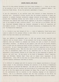
Six pages titled New Chum Reef. No number on the first page, the others are 109 to 113. Mentions location of the reef and some of the rich mines. The mines are mentioned in a table with the Name of Mine; Depth; Production; Dates; Plant, Machinery, Comments and Position. Ballerstedt, Ashley and Noy, and Grant were three of the successful miners. Mines mentioned are: South Goldfields, New Chum Goldfields, South New Chum, Lansell's 616, South Bellevue, Eureka, Eureka Extended, New Chum Bellevue, New chum Railway, Shenandoah, North Shenandoah, Shamrock, Old Chum, Little Chum, Young Chum, Craven, Garibaldi, Ellesmere, South Old Chum, New Chum Consolidated, North Ellesmere, New Chum United, Lansell's 222, Lansell's Fortuna, Lazarus, West End, Pioneer, Old Chum, New Chum Victoria, North Old Chum, Lansell's Big 180, Sterry, Victoria Quartz, South Adventure, Great Central Victoria, Ballerstedt No 3, Adventure, Humbold, British and American, Midway, Victoria Consuls, Victoria absorbed by Ironbark, Hercules and Energetic, Victoria Pilot, North Hercules and Energetic, Great Extended Hercules, Pearl, Southern Victoria, Great Extended Victoria, Young Victoria, New Catherine Victoria, Weatern Victoria, New Victoria St Mungo, Surprise, Mystery, Duke of Edinburgh, New St Mungo, Duchess Tribute, South Devonshire, Duchess of Edinburgh, West United Devonshire, Albert, United Devonshire, Saxon and Celt, Hopewell, Prince of Wales, Phoenix, Unicorn, South St Mungo, Princess Alice, Lady Barkly, North Devonshire, Ranzeau, St Mungo, Dublin and Cornwall, Sadowa, Eastwood, Ellenborough, Belmont and Saxeby, Snobs Hill, York and Durham, La bElle, Old Williams United, Arcadia, Williams United, South Catherine, Central Catherine, Catherine United, Murchison, New Franklin, Catherine Extended, Pony Club Oval, Housing Commission, Mt Alvernia Hospital, Fortuna, Lunt, Army Survey Unit, Wybrandt, John Brown Factory, Canterbury, Hercules and Energetic and the North Red White and Blue.bendigo, history, long gully history group, the long gully history group - new chum reef, ballerstedt, ashley and noy, grant, south goldfields, new chum goldfields, south new chum, lansell's 616, south bellevue, eureka, eureka extended, new chum bellevue, new chum railway, shenandoah, north shenandoah, shamrock, old chum, little chum, young chum, craven, garibaldi, ellesmere, south old chum, new chum consolidated, north ellesmere, new chum united, lansell's 222, lansell's fortuna, lazarus, west end, pioneer, old chum, new chum victoria, north old chum, lansell's big 180, sterry, victoria quartz, south adventure, great central victoria, ballerstedt no 3, adventure, humbold, british and american, midway, victoria consuls, victoria absorbed by ironbark, hercules and energetic, victoria pilot, north hercules and energetic, great extended hercules, pearl, southern victoria, great extended victoria, young victoria, new catherine victoria, weatern victoria, new victoria st mungo, surprise, mystery, duke of edinburgh, new st mungo, duchess tribute, south devonshire, duchess of edinburgh, west united devonshire, albert, united devonshire, saxon and celt, hopewell, prince of wales, phoenix, unicorn, south st mungo, princess alice, lady barkly, north devonshire, ranzeau, st mungo, dublin and cornwall, sadowa, eastwood, ellenborough, belmont and saxeby, snobs hill, york and durham, la belle, old williams united, arcadia, williams united, south catherine, central catherine, catherine united, murchison, new franklin, catherine extended, pony club oval, housing commission, mt alvernia hospital, fortuna, lunt, army survey unit, wybrandt, john brown factory, canterbury, hercules and energetic, north red white and blue -
 Kew Historical Society Inc
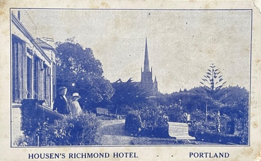
Postcard, Housen's Richmond Hotel | Portland
Many of the Henty's of the Western District of Victoria also owned houses in Kew, Victoria. Stephen Henty, referred to on the reverse of the postcard, lived while a member of the Vitoria Parliament at 'Findon' in Kew. Kew Historical Society also holds a nationally significant collection of costumes belonging to three generations of Henty women.Monochrome, blue tinted 'real photo' postcard of Housen's Richmond Hotel, Portland. Two women stand on the steps of the hotel at left, with the rose garden in front of them. Behind them is a church spire. The hotel and its significance is outlined in two columns of blue coloured text on the reverse.Printed reverse: "THE RICHMOND is the most historical building in the State. On the site of today's building Edward Henty, the founder of permanent settlement in Victoria, commenced his first house February 19, 1835, finishing the work in two months. He had landed in Portland on Nov. 19th, 1834, and turned the first plough furrows in Victoria where the Hotel now stands on the 26th of the following month. It was also here that Major Mitchell ended his explorations from Sydney, meeting the Hentys on August 29th, 1836. In December of the same year Mrs S. G. Henty joined her husband, their son Richmond, the first male white child in Portland, being born in the Henty cottage. The present Richmond Hotel was built in 1840, and became the home of Stephen Henty until his departure from Portland in 1869. Though Edward Henty's first house was demolished in 1840, to make room for the new surveyed town streets, part of his wool store remains in the Hotel grounds, and is used as a wood shed. This is about the oldest building in the State : in it was held the first christening service in Portland on September 26th, 1841. On the site of the Richmond Hotel all the early visiting celebrities were entertained - Mitchell, Wedge, La Trobe, Fyans, Sir John Franklin, Capt. Stokes, etc. No other hostelry in Victoria can give you the historical atmosphere of the RICHMOND. / THE ORIGINAL HOME OF THE HENTYS."henty family, richmond hotel -- portland (vic.), stephen henty, edward henty, richmond henty, henty houses -- victoria, portland, postcards -
 Tarnagulla History Archive
Set of Maps (Mining & Local Area), various
David Gordon Collection. A set of mining documents, maps and plans: 1. Dunolly Deep Leads - showing location and names of deep lead gold deposits in region around Dunolly including at Tarnagulla and Newbridge. Geological Survey of Victoria, Department of Minerals and Energy. Bulletin No. 62, Map No. 4 Dunolly (770 x 485 mm). 2. Poseidon Lead (Facsimile) 3. Nick O Time Lead (Facsimile) 4. Happy Go Lucky Mine prospectus and plan (colour copy) 5. Jones Creek GM Co. (Raven & Gourlay's) Waanyarra - Prospectus (colour copy) 6. Poseidon Area Plan (colour copy) and Poseidon Area map (B&W copy). 7. Cross-section diagram of Spread Eagle Reef 8. New Birthday Gold Mine - area map (colour copy) and mine cross-section ( (colour copy). 9. Cross section of Poverty Reef, by Department of Mines (B&W copy, 2 parts on A2 paper) 10. Time-Lease Graph for Watts Reef, Specimen Reef, Stony Reef, Poverty Reef (second page in detail), created by Eric WIlkinson for Ref Mining NL, 1995 11. 1859 Plan of the Gold Workings & Township of Sandy Creek, Shewing the Mining Leases, Extended Claims & Machinery by R.J. McMillan, Mining Surveyor (B&W copy) 12. Longitundinal and Transverse Vertical Sections of Poverty Reef, Sandy Creek 1859, by R.J. McMillan, Mining Surveyor (B&W copy) 13. Tarnagulla Locality Plan (B&W copy) 14. Universal Grid Reference Map (Topographic) for Laanecoorie North (2 copies) 15. Universal Grid Reference Map (Topographic) for Inglewood South 16. Poverty Reef, Plan showing shafts and early tenements, created by Eric WIlkinson for Ref Mining NL, 1995 17. Locality Map of mining leases in Tarnagulla 18. Plan and Elevation of part of Poverty Reef, Sandy Creek, showing the claims and positions of the shaft. by R.J. McMillan, Mining Surveyor (Facsimile, composed of taped together components) 19.Plan and Elevation of part of Poverty Reef, Sandy Creek, showing the claims and positions of the shaft. by R.J. McMillan, Mining Surveyor (Facsimile, composed of taped together components) -
 Federation University Historical Collection
Photograph (black & White), Major General, Sir William Penn Symons - South Africa
William Penn Symons' first combat experience was in South Africa during the Ninth Xhosa War, 1877-78. In 1879 he took part in the Zulu war. He then served during the Burma Expedition (1885-89). In 1889 he received the Companion of the Order of the Bath. In 1898, following other campaigns, he was awarded the Knight Commander of the Order of the Bath. In 1899, Symons was given the staff rank of brigadier general and was to be General Officer Commanding of Natal. He was asked by the War Office to advise on the number of troops required to safely garrison the Natal from the threat of invasion from the Boer Republics of the Transvaal and Orange Free states. Cabinet decided to send ten thousand extra troop abut they also appointed Lieutenant General Sir George White to supersede Symons as Generat Officer Commanding in Natal. Penn Symons, on his own authority deployed one of his brigades to Dundee, a town north of Ladysmith. The position of Ladysmith anad Dundee was precarious as they stand in a triangle of Natal, Orange Free State and Transvaal. White wanted to recall the Dundee garrison to Ladysmith but because of political pressure from Sit Walter Hely-Harrison, the Governor of Natal, he agreed to leave them there. The Boers declared war on 11 October and began crossing the Natal borders the following day. On 20 October 1899 Boer troops on the nearby Talana Hill proceeded to open fire on the town. The British guns moved to return fire as the general surveyed the Boer positions and gave orders to his commanding officers. Symons believed in old fashioned military tactics of close order but these formations were not designed to be used against lonf range bolt action rifles and Symons' brigades would be the first of manyin this war to pay the heavy cost ofthe mistake, as many generals would repeat it. The infantry battalions set off from the east of the town. The first part of the advance went well and they reached a small wood at the foot of the hill where they found shelter. Beyond the wood was a wall and then open ground. Symons rode up to the wood to find out why the attack had halted. He ordered the men to proceed, rode through the wood then walked through the gap in the wall. After a few moments he returned and was helped to remount his horse. He rode back from the front lines until he was out of sight of his troops before he asked for assistance from the Indian stretcher bearers. He had been shot in the stomach. Symons was taken to the field hospital at Dundee. After a few wasted days Symons' replacement, Brigadier General Yule, decided to abandon the town and the worst-wounded to the Boers and steal away at night to Ladysmith. Symons became a prisoner of war along with many others. He felt betrayed by Yule and just before he died he implored the medical officer, Major Donegal, to "tell everyone I died facing the enemy". Individual image from photographed poster of tobacco and cigarette cards.william penn symons, south africa, ninth xhosa war, companion of the order of the bath, knigt commander of the order of the bath, general officer commanding in natal, dundee, ladysmith, orange free state, transvaal, sir walter hely-harrison, governor of natal, boers, brigadier general yule -
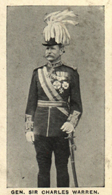 Federation University Historical Collection
Photograph (black & White), General Sir Charles Warren - South Africa
General Sir Charles Warren was an officer in the British Royal Engineers. He was one of the earliest European archaeologists ofthe Holy Land. Much of his military service was spene in British South Africa. Previously he was police chief, the Head of the London Metropolitan Police during the Jack the Ripper murders. In 1876, the Colonial Office appointed him special commissioner to survey the boundary between Griqualand West and the Orange Free State. For this work he was made a Companion of the Order of St Michael and St George in 1877. He was appointed special commissioner to investigate "native questions" in Bechuanaland and commanded the Northern Border Expedition troops in quelling the rebellion there. In 1879 he became Administrator of Griqualand West. The town Warranton in the Northern Cape Province of South Africa is named after him. In 1882 the Admiralty sent him to Sinai to discover what had happened to Professor Edward Palmer's archaeological expedition. He discovered the members had been robbed and murdered, located their remains and brought their killers to justice. For this he was created a Knight Commander of the Order of St Michael and St George in 1883 , also Knight of Justice of the Order of St John of Jerusalem and in 1884 elected a Fellow of the Royal Society. In 1884 Warren was sent as HM Special Commissioner to command a military expedition to Bechuanaland, to assert British sovereignty in the face of encroachments from Germany and the Transvaal and to suppress the Boer freebooter states of Stellaland and Goshen, which were backed by the Transvaal and were stealing land and cattle from the local Tswana tribes. This became known as the Warren Expedition and achieved its aims without bloodshed. Warren was recalled and in 1885 was made Knight Grand Cross ofthe Order of St Michael and St George. In 1885 Warren stood for election for Parliament but lost the vote. In 1886 he was appointed Commissioner of Police of the Metropolis following Sir Edmund Henderson's resignation. Criticised continually for his decisions and actions he resigned in November 1888. Prior to this time he was appointed Knight Commander of the Order of the Bath, January 1888. On the outbreak of the Boer War in 1899 he returned to service and commanded the 5th Division of the South African Field Force. In January 1990, Warren bungled the second attempted relief of Ladysmith at Tugela River. At the Battle of Spion Kop, January 1990 he had operational command and his failure of judgement, delay and indecision despite his superior forces culminated in the disaster. It has been said that Warren was "perhaps the worst" of the British generals in the Boer War and certainly the most "preposterous". Redvers Buller in a letter to his wife described him as "a duffer", responsible for him losing him "a great chance". Warren was recalled to Britain in August 1900 and never again commanded troops in the field. Individual image from photographed poster of tobacco and cigarette cards.holy land, sir charles warren, british royal engineers, archaeologist, british south africa, london metropolitan police, jack the ripper, colonial office, commissioner, griqualand west, orange free state, companion of the order of st michael and st george, bechuanaland, northern border expedition, warrenton, sinai, professor edward palmer, knight commander of the order of st michael and st george, knight of justice of the order of st johnof jerusalem, fellow of the royal society, knight grand cross of the order of st michael and st george, boer war, redvers buller, knight commander of the order of the bath -
 Flagstaff Hill Maritime Museum and Village
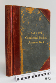
Financial record - Medical Accounts, c. 1929
The accounts records in the Medical Accounts book start in February 1929 and refer to many of Warrnambool’s local names and addresses. The ledger book belonged to Dr John Hunter Henderson who conducted his medical practice from his home and surgery at Birchwood, 214 Koroit Street, Warrnambool, from 1904-1939. This particular accounts book spans from February 1929 to May 1931. Dr Henderson retired in 1939 and moved to Melbourne. His home, medical practice and many of his surgery’s items, including the Medical Accounts Book, were transferred to Dr William Roy Angus in that same year. The patients’ addresses on page 1 of the ledger include John Lee of St Marys Road, Wangoom. John Lee’s name has two entries on this page. He Grandfather, also John Lee, was a notable pioneer of the district. JOHN LEE John Lee was born in 1884 and died in 1948. His father (1845-1892) and grandfather (1814-1887) were also named John Lee. John Lee’s Grandfather, Grandmother, Father and Uncle arrived in Australia from Ireland in 1852. The colonial family settled in St Marys Road, Wangoom, Victoria and have a long association with the district. John Lee, born in 1814, is proudly listed amongst the names on the commemorative Warrnambool Pioneers Board, having arrived in Australia In 1852. In 1855 John’s Grandfather John Lee, aged 41, was head teacher of the Tower Hill School on the south bank of Tower Hill. Two years later, in 1857, the north bank of Tower Hill was surveyed and named the township of Koroit. In November of that year John Lee continued on as head master, now at the newly built Tower Hill Lake National School Number 618, on land that is now Victoria Park Recreation Reserve, on High Street, Koroit. John died in Warrnambool in 1887 but even 50 years later an ex-student wrote a letter to The Age newspaper, recalling memories of John Lee, his head master of the 1860s at the Tower Hill Lake Common School in Koroit. DR WILLIAM ROY ANGUS Doctor Angus had previously practiced in Nhill. The accounts book and many more items of Dr Angus were donated to Flagstaff Hill Maritime Village by the family of Dr Angus, Surgeon and Oculist. The Medical Accounts Book is part of the “W.R. Angus Collection” that includes historical medical equipment, surgical instruments and material once belonging to Dr Edward Ryan and Dr Thomas Francis Ryan, (both of Nhill, Victoria) as well as Dr Angus’ own belongings. The Collection’s history spans the medical practices of the two Doctors Ryan, from 1885-1926 plus that of Dr John Henderson from 1904+1939 and Dr Angus until he retired, from 1923 - 1969. The Medical Accounts Book is significant as a record of the names, addresses and health of the people in Warrnambool and District in the early 20th century. The Book is significant for its early 20th century association with two local doctors, Dr John Henderson and Doctor William Roy Angus, whose practices span from 1904-1969. The Book is also significant historically for its association with the ancestors of patient John Lee, whose Grandfather is recognised on the Warrnambool pioneer Board as one of the early pioneers in Victoria, arriving in 1852. Ledger, Medical Accounts Book. Title is Bruck’s Condensed Medical Account Book. Book has hardback, green cover, bound and reinforced with red leather and printed title in gold lettering. The pages of index tabs in the beginning of the book have no entries. The first page of the accounts section of the book have the hand written heading “February 1929”. The book continues until the end of May 1931. Inside both front and back cover are hand written notes in different scrips. Both black and blue ink has been used. The book belonged to Dr John Hunter Henderson. It is part of the W.R. Angus Collection."Bruck’s Condensed Medical Account Book"flagstaff hill, warrnambool, shipwrecked coast, flagstaff hill maritime museum, maritime museum, shipwreck coast, flagstaff hill maritime village, great ocean road, medical treatment, medical history, medical accounts, medical administration, medical record 1929, ledger, bruck’s condensed medical account book, john hunter henderson, william roy angus, edward ryan, thomas francis ryan, john lee, tower hill school, tower hill lake national school, koroit primary school, victoria school 628, st marys wangoom, warrnambool pioneer, birchwood, 214 koroit street warrnambool -
 Kew Historical Society Inc
Plaque, Kew City Hall : Opened by The Hon H.E. Bolte M.L.A. Premier of Victoria 23rd April 1960 : Cr H.H. Ferguson J.P. Mayor, 1960
The Municipality of Kew was proclaimed on 19 December 1860, then upgraded to a Borough (1863), a Town (1910) and finally a City (1921). From 1865, its offices were based in the former Athenaeum Hall in Walpole Street, which, although extended in 1883, inevitably became inadequate. Plans for a new purpose-built Town Hall were first mooted in the late 1880s, but fell prey to six subsequent decades of debate. During that time, many sites were considered and rejected, and several schemes prepared. Finally, in 1945, it was resolved to build a new civic centre as a war memorial. The council acquired Southesk, a mansion on the south-west corner of Cotham Road and Charles Street – first mooted as a possible Town Hall site two decades earlier – and plans for a civic precinct were drawn up by John Scarborough. The project stalled until 1957, when a Town Hall Committee was formed and a new architect appointed: Harold Bartlett of Leith & Bartlett. He also proposed an entire civic precinct, of which a large public hall would constitute Stage One. Designed to accommodate almost any public or official function, the space had had a small stage at one end for intimate theatrical productions, a larger stage at the other (with operable sunken orchestra pit) for musical performances, plus the most up-to-date equipment for live TV transmission. The building, befitting its original intent as a war memorial, was also to include a sculpted monument, for which a separate design competition was held. First prize went to George H Allen (1900-1972), long-time head of the Sculpture Department at RMIT and a former war artist himself (the only one, in fact, to have worked in the medium of sculpture). At the time of the Kew project, Allen was best known for his Cenotaph at the Shrine of Remembrance (1955) and a controversial abstract sculpture at Hume House in William Street (1957). Tenders for the new hall were called and the contract (worth £104,986) was awarded to H F Yuncken. The foundation stone was laid by the Mayor, Cr F C O'Brien, on 1 June 1959. Completion (initially scheduled for October) was delayed by the unavailability of certain materials; it was barely finished in time for the official opening (by Premier Henry Bolte) on 23 April 1960. The war memorial was unveiled two days later (Anzac Day) by Bolte's deputy, the Hon A G Rylah. Fittingly, that year also marked Kew's municipal centenary, and many celebratory events were held in and around the new civic centre in December, including a special council meeting (attended by the Prime Minister), a tree planting ceremony and a youth ball. Source: Survey of Built Heritage in Victoria: Stage Two (Built Heritage Pty Ltd., 2010)Plaque commemorating the opening of a new town hall in KewMetal plaque recording the official opening of the Kew City Hall, 23rd April 1960. This plaque was given to the Kew Historical Society in 1991 by the former City of Kew.Kew City Hall / Opened by / The Hon. H.E. Bolte M.L.A. / Premier of Victoria / 23rd April 1960 / Cr. H.G. Ferguson J.P. - Mayor.kew city hall, foundation stones - kew (vic), sir henry bolte, local government -- kew (vic.) -
 Kew Historical Society Inc
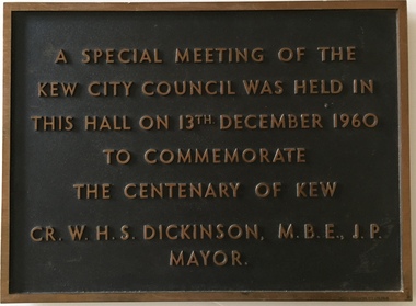
Plaque, A Special Meeting of the Kew City Council Was Held in This Hall on 13th December 1960 to Commemorate the Centenary of Kew : Cr. W.H.S. Dickinson M.B.E., J.P. Mayor, 1960
The Municipality of Kew was proclaimed on 19 December 1860, then upgraded to a Borough (1863), a Town (1910) and finally a City (1921). From 1865, its offices were based in the former Athenaeum Hall in Walpole Street, which, although extended in 1883, inevitably became inadequate. Plans for a new purpose-built Town Hall were first mooted in the late 1880s, but fell prey to six subsequent decades of debate. During that time, many sites were considered and rejected, and several schemes prepared. Finally, in 1945, it was resolved to build a new civic centre as a war memorial. The council acquired Southesk, a mansion on the south-west corner of Cotham Road and Charles Street – first mooted as a possible Town Hall site two decades earlier – and plans for a civic precinct were drawn up by John Scarborough. The project stalled until 1957, when a Town Hall Committee was formed and a new architect appointed: Harold Bartlett of Leith & Bartlett. He also proposed an entire civic precinct, of which a large public hall would constitute Stage One. Designed to accommodate almost any public or official function, the space had had a small stage at one end for intimate theatrical productions, a larger stage at the other (with operable sunken orchestra pit) for musical performances, plus the most up-to-date equipment for live TV transmission. The building, befitting its original intent as a war memorial, was also to include a sculpted monument, for which a separate design competition was held. First prize went to George H Allen (1900-1972), long-time head of the Sculpture Department at RMIT and a former war artist himself (the only one, in fact, to have worked in the medium of sculpture). At the time of the Kew project, Allen was best known for his Cenotaph at the Shrine of Remembrance (1955) and a controversial abstract sculpture at Hume House in William Street (1957). Tenders for the new hall were called and the contract (worth £104,986) was awarded to H F Yuncken. The foundation stone was laid by the Mayor, Cr F C O'Brien, on 1 June 1959. Completion (initially scheduled for October) was delayed by the unavailability of certain materials; it was barely finished in time for the official opening (by Premier Henry Bolte) on 23 April 1960. The war memorial was unveiled two days later (Anzac Day) by Bolte's deputy, the Hon A G Rylah. Fittingly, that year also marked Kew's municipal centenary, and many celebratory events were held in and around the new civic centre in December, including a special council meeting (attended by the Prime Minister), a tree planting ceremony and a youth ball. Source: Survey of Built Heritage in Victoria: Stage Two (Built Heritage Pty Ltd., 2010)Historically significant commemorative plaqueMetal plaque relating to special Council meeting to mark centenary of Kew, 13th December 1960. This plaque was given to the Kew Historical Society in 1991 by the former City of Kew.A Special Meeting Of The / Kew City Council Was Held In / This Hall On 13th December 1960 / To Commemorate / The Centenary of Kew / Cr. W.H.S. Dickinson, M.B.E., J.P., / Mayorkew city hall, foundation stones - kew (vic), cr. w.h.s. dickinson, local government -- kew (vic.) -
 Flagstaff Hill Maritime Museum and Village
Freezer, circa 1930's
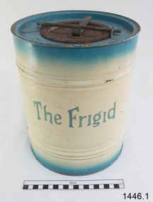
This ice cream freezer, manufactured in South Australia in the 1930's, was advertised to "keep the contents of the cream compartment frozen for many hours". It was promoted for use at picnics to keep salads cool. Its design is very similar to other freezers of The Frigid name which were made in 1939; those freezers were all one colour whereas this one is blue around the top and bottom of the barrel and cream in the centre with blue/green lettering. The process of making ice cream was to pack the outer chamber full with a combination of 3 parts ice cubes of about 1 inch (2.cm) to one part coarse salt, then pour into the chamber about 1 cup of cold water. After this, the ingredients for ice cream or sorbet were poured into the inner chamber, then attach the lid and turn The Frigid freezer upside down for about 40 minutes or until the right consistency is reached. Advice as given to open the freezer every 20 minutes and stir around the contents that were frozen against the sides of the inner chamber. The ingredients for the ice cream could include cream, sugar, vanilla and eggs. The label on the box of The Frigid shows the address of A Simpson and Son to be at Pirie Street, Adelaide. This address was used as early as 1876 and later catalogues, 1931 - 1960 still show this address. Alfred Simpson and his family emigrated from England, arriving in South Australia in 1849. He had already completed his apprenticeship as a tinplate worker but he tried various other occupations, including trying out the gold mines in Victoria, before he established himself as a tinsmith in 1853. His products included many agricultural items. His son, Alfred Muller Simpson, joined the business when he turned 21. In the 1860 Simpson's products included 'explosion proof' safes. In the late 1880's A Simpson and Son manufactured munitions and mines for the war. At the time of Alfred's death in 1891, A Simpson and Son had the largest metal manufacturing plant in Australia. From 1898 the company's reputation grew from the process of enamel plating with porcelain. During the First World War, Simpsons returned to the manufacture of munitions. Alfred M. Simpson's sons (Alfred Allen, known as Allen, and Fredrick Neighbour) joined the company when they finished their schooling. Allen was also associated with the Royal Geological Society over many years and when the CT Madigan surveyed Central Australia in 1929, the Simpson Desert was named in his honour. Cape Simpson in Antarctica is also named after him due to his assistance to Douglas Mawson. A new factory was opened at Dudley Park in the 1940s and the company began the manufacture of whitegoods. In 1963 A. Simpson and Son merged with Pope Industries to form Simpson Pope Holdings. Alfred Simpson became chairman of the board of Simpson Pope Holdings. The Simpson brand, now owned by Electrolux, continues to produce a variety of household appliances. (Reference: State Library of South Australia) A Simpson and Son was an early colonial business that has lasted well into the 20th century and the name Simpson is still associated with whitegoods. Freezer, 2 quart (1.8 litre) capacity, made by A Simpson and Son Ltd, marked "The Frigid". Cylinder shaped, constructed from enamelled sheet metal, has two catches one on the base and one on top. Inner cylinder for holding contents for freezing. Slightly rusted. Freezer is inside original cardboard box with yellow label showing manufacturer details. Circa 1930'sOutside of freezer is printed in blue"The Frigid". Box includes "THE "FRIGID" FREEZER" and branded "S & S" inside a circle.flagstaff hill, warrnambool, shipwrecked-coast, flagstaff-hill, flagstaff-hill-maritime-museum, maritime-museum, shipwreck-coast, flagstaff-hill-maritime-village, a. simpson & son limited, manufacturer, foundry, freezer, 2 quart freezer, portable freezer, kitchen appliance, the frigid, ice cream freezer, ice cream maker 1930's -
 Eltham District Historical Society Inc
Photograph, Former Eltham Police Residence, 728 Main Road, Eltham, c.1985, 1985c
This photo is believed to have been taken circa 1985 when the Shire of Eltham Parks and Environment occupied the site. This photo was originally mounted on 3mm MDF fibre board with notes and stickers applied as part of a display on the former Police Residence and now present day Local History Centre, home to Eltham District Historical Society; possibly put together by Harry Gilham during his time as president of the society. Eltham Police Station and Residence: A brief history 1860 Eltham Courthouse built in Main Road, together with an adjoining police residence, office, lock–up and stables. 1959 Police Department purchases a house in Pryor Street to be refurbished as Eltham Police Station 1961 Police in Eltham move into Pryor Street refurbished buildings and office. c.1961-1981 Occupied by Vermin and Noxious Weeds Destruction Section of the Department of Crown Lands and Survey. Former Police Station dragged around to rear of Police Residence (prior to August 1967) to make way for the construction of a driveway and access from Main Road. The building was placed on the site of a former Scullery and modified for Lands Department use. 1981 Shire of Eltham take over management of old Police Residence in Eltham. It remains unoccupied for a period of time whilst its future is discussed in Council. 1981-1985 Used for community job creation scheme 1985 Shire of Eltham Parks and Environment occupy the residence. Council improve the driveway but later add a second rear access from Brougham Street due to the dangerous nature of the Main Road entrance. Also add a rear toilet facility between the Police Residence and former Police Station, which was doubling up as a lunch room. Council also commence discussions to re-establish a replica Police Station. c.1986 November. Former Police Station demolished; believed to have been suffering termite damage. c.1989 After some years of discussion a replica Police Station is built, based on photographs, to act as a lunch room and meeting room for Parks and Environment staff and volunteers doing community service. 1996 Eltham District Historical Society in discussions with Nillumbik Shire Council commisioners throughout the year regarding a home for the Society. A proposal put forward by the Society in October to occupy the former Police Residence. 1997 March. Eltham District Historical Society gains access to former Police Residence. 1998 July 12th. Eltham District Historical Society Inc moves into its Local History Centre, 728 Main Road Eltham (the former Police Residnce built in 1860). 2018 July. Eltham District Historical Society gains access to the replica Police Station for use as part of regular heritage tours for schools and community based groups.Colour printHandwritten in faded blue felt pen ink "No. 3 - Front of 728 Police Residence. 1860 Court House over the paling fence. Verandah missing from earlier photographs"728 main road, eltham, local history centre, parks and environment, police residence, police station, shire of eltham -
 Eltham District Historical Society Inc
Photograph, Former Eltham Police Residence, 728 Main Road, Eltham, c.1985, 1985c
This photo is believed to have been taken circa 1985 when the Shire of Eltham Parks and Environment occupied the site. This photo was originally mounted on 3mm MDF fibre board with notes and stickers applied as part of a display on the former Police Residence and now present day Local History Centre, home to Eltham District Historical Society; possibly put together by Harry Gilham during his time as president of the society. Eltham Police Station and Residence: A brief history 1860 Eltham Courthouse built in Main Road, together with an adjoining police residence, office, lock–up and stables. 1959 Police Department purchases a house in Pryor Street to be refurbished as Eltham Police Station 1961 Police in Eltham move into Pryor Street refurbished buildings and office. c.1961-1981 Occupied by Vermin and Noxious Weeds Destruction Section of the Department of Crown Lands and Survey. Former Police Station dragged around to rear of Police Residence (prior to August 1967) to make way for the construction of a driveway and access from Main Road. The building was placed on the site of a former Scullery and modified for Lands Department use. 1981 Shire of Eltham take over management of old Police Residence in Eltham. It remains unoccupied for a period of time whilst its future is discussed in Council. 1981-1985 Used for community job creation scheme 1985 Shire of Eltham Parks and Environment occupy the residence. Council improve the driveway but later add a second rear access from Brougham Street due to the dangerous nature of the Main Road entrance. Also add a rear toilet facility between the Police Residence and former Police Station, which was doubling up as a lunch room. Council also commence discussions to re-establish a replica Police Station. c.1986 November. Former Police Station demolished; believed to have been suffering termite damage. c.1989 After some years of discussion a replica Police Station is built, based on photographs, to act as a lunch room and meeting room for Parks and Environment staff and volunteers doing community service. 1996 Eltham District Historical Society in discussions with Nillumbik Shire Council commisioners throughout the year regarding a home for the Society. A proposal put forward by the Society in October to occupy the former Police Residence. 1997 March. Eltham District Historical Society gains access to former Police Residence. 1998 July 12th. Eltham District Historical Society Inc moves into its Local History Centre, 728 Main Road Eltham (the former Police Residnce built in 1860). 2018 July. Eltham District Historical Society gains access to the replica Police Station for use as part of regular heritage tours for schools and community based groups.Colour printHandwritten in faded blue felt pen ink "No. 2 - Backyard of 728 #5 Weatherboard 'Office'. Note 1860 Court House over the fence."728 main road, eltham, local history centre, parks and environment, police residence, police station, shire of eltham -
 Eltham District Historical Society Inc
Photograph, Former Eltham Police Residence, 728 Main Road, Eltham, c.1985, 1985c
This photo is believed to have been taken circa 1985 when the Shire of Eltham Parks and Environment occupied the site. This photo was originally mounted on 3mm MDF fibre board with notes and stickers applied as part of a display on the former Police Residence and now present day Local History Centre, home to Eltham District Historical Society; possibly put together by Harry Gilham during his time as president of the society. Eltham Police Station and Residence: A brief history 1860 Eltham Courthouse built in Main Road, together with an adjoining police residence, office, lock–up and stables. 1959 Police Department purchases a house in Pryor Street to be refurbished as Eltham Police Station 1961 Police in Eltham move into Pryor Street refurbished buildings and office. c.1961-1981 Occupied by Vermin and Noxious Weeds Destruction Section of the Department of Crown Lands and Survey. Former Police Station dragged around to rear of Police Residence (prior to August 1967) to make way for the construction of a driveway and access from Main Road. The building was placed on the site of a former Scullery and modified for Lands Department use. 1981 Shire of Eltham take over management of old Police Residence in Eltham. It remains unoccupied for a period of time whilst its future is discussed in Council. 1981-1985 Used for community job creation scheme 1985 Shire of Eltham Parks and Environment occupy the residence. Council improve the driveway but later add a second rear access from Brougham Street due to the dangerous nature of the Main Road entrance. Also add a rear toilet facility between the Police Residence and former Police Station, which was doubling up as a lunch room. Council also commence discussions to re-establish a replica Police Station. c.1986 November. Former Police Station demolished; believed to have been suffering termite damage. c.1989 After some years of discussion a replica Police Station is built, based on photographs, to act as a lunch room and meeting room for Parks and Environment staff and volunteers doing community service. 1996 Eltham District Historical Society in discussions with Nillumbik Shire Council commisioners throughout the year regarding a home for the Society. A proposal put forward by the Society in October to occupy the former Police Residence. 1997 March. Eltham District Historical Society gains access to former Police Residence. 1998 July 12th. Eltham District Historical Society Inc moves into its Local History Centre, 728 Main Road Eltham (the former Police Residnce built in 1860). 2018 July. Eltham District Historical Society gains access to the replica Police Station for use as part of regular heritage tours for schools and community based groups.Colour printHandwritten in faded blue felt pen ink "Roof of room 5 (weatherboard office) and W.C. See No. 2 for another view"728 main road, eltham, local history centre, parks and environment, police residence, police station, shire of eltham -
 Eltham District Historical Society Inc
Photograph, Former Eltham Police Residence, 728 Main Road, Eltham, c.1985, 1985c
This photo is believed to have been taken circa 1985 when the Shire of Eltham Parks and Environment occupied the site. This photo was originally mounted on 3mm MDF fibre board with notes and stickers applied as part of a display on the former Police Residence and now present day Local History Centre, home to Eltham District Historical Society; possibly put together by Harry Gilham during his time as president of the society. Eltham Police Station and Residence: A brief history 1860 Eltham Courthouse built in Main Road, together with an adjoining police residence, office, lock–up and stables. 1959 Police Department purchases a house in Pryor Street to be refurbished as Eltham Police Station 1961 Police in Eltham move into Pryor Street refurbished buildings and office. c.1961-1981 Occupied by Vermin and Noxious Weeds Destruction Section of the Department of Crown Lands and Survey. Former Police Station dragged around to rear of Police Residence (prior to August 1967) to make way for the construction of a driveway and access from Main Road. The building was placed on the site of a former Scullery and modified for Lands Department use. 1981 Shire of Eltham take over management of old Police Residence in Eltham. It remains unoccupied for a period of time whilst its future is discussed in Council. 1981-1985 Used for community job creation scheme 1985 Shire of Eltham Parks and Environment occupy the residence. Council improve the driveway but later add a second rear access from Brougham Street due to the dangerous nature of the Main Road entrance. Also add a rear toilet facility between the Police Residence and former Police Station, which was doubling up as a lunch room. Council also commence discussions to re-establish a replica Police Station. c.1986 November. Former Police Station demolished; believed to have been suffering termite damage. c.1989 After some years of discussion a replica Police Station is built, based on photographs, to act as a lunch room and meeting room for Parks and Environment staff and volunteers doing community service. 1996 Eltham District Historical Society in discussions with Nillumbik Shire Council commisioners throughout the year regarding a home for the Society. A proposal put forward by the Society in October to occupy the former Police Residence. 1997 March. Eltham District Historical Society gains access to former Police Residence. 1998 July 12th. Eltham District Historical Society Inc moves into its Local History Centre, 728 Main Road Eltham (the former Police Residnce built in 1860). 2018 July. Eltham District Historical Society gains access to the replica Police Station for use as part of regular heritage tours for schools and community based groups.Colour printHandwritten in faded blue felt pen ink "Another view of north wall 728 No. 4. Taken from west end towards back yard"728 main road, eltham, local history centre, parks and environment, police residence, police station, shire of eltham -
 Eltham District Historical Society Inc
Photograph, Former Eltham Police Residence, 728 Main Road, Eltham, c.1985, 1985c
This photo is believed to have been taken circa 1985 when the Shire of Eltham Parks and Environment occupied the site. This photo was originally mounted on 3mm MDF fibre board with notes and stickers applied as part of a display on the former Police Residence and now present day Local History Centre, home to Eltham District Historical Society; possibly put together by Harry Gilham during his time as president of the society. Eltham Police Station and Residence: A brief history 1860 Eltham Courthouse built in Main Road, together with an adjoining police residence, office, lock–up and stables. 1959 Police Department purchases a house in Pryor Street to be refurbished as Eltham Police Station 1961 Police in Eltham move into Pryor Street refurbished buildings and office. c.1961-1981 Occupied by Vermin and Noxious Weeds Destruction Section of the Department of Crown Lands and Survey. Former Police Station dragged around to rear of Police Residence (prior to August 1967) to make way for the construction of a driveway and access from Main Road. The building was placed on the site of a former Scullery and modified for Lands Department use. 1981 Shire of Eltham take over management of old Police Residence in Eltham. It remains unoccupied for a period of time whilst its future is discussed in Council. 1981-1985 Used for community job creation scheme 1985 Shire of Eltham Parks and Environment occupy the residence. Council improve the driveway but later add a second rear access from Brougham Street due to the dangerous nature of the Main Road entrance. Also add a rear toilet facility between the Police Residence and former Police Station, which was doubling up as a lunch room. Council also commence discussions to re-establish a replica Police Station. c.1986 November. Former Police Station demolished; believed to have been suffering termite damage. c.1989 After some years of discussion a replica Police Station is built, based on photographs, to act as a lunch room and meeting room for Parks and Environment staff and volunteers doing community service. 1996 Eltham District Historical Society in discussions with Nillumbik Shire Council commisioners throughout the year regarding a home for the Society. A proposal put forward by the Society in October to occupy the former Police Residence. 1997 March. Eltham District Historical Society gains access to former Police Residence. 1998 July 12th. Eltham District Historical Society Inc moves into its Local History Centre, 728 Main Road Eltham (the former Police Residnce built in 1860). 2018 July. Eltham District Historical Society gains access to the replica Police Station for use as part of regular heritage tours for schools and community based groups.Colour printHandwritten in faded blue felt pen ink "Repeat view of No. 4 from external corner of weatherboard extn. Room 5"728 main road, eltham, local history centre, parks and environment, police residence, police station, shire of eltham -
 Eltham District Historical Society Inc
Photograph, Former Eltham Police Residence, 728 Main Road, Eltham, c.1985, 1985c
This photo is believed to have been taken circa 1985 when the Shire of Eltham Parks and Environment occupied the site. This photo was originally mounted on 3mm MDF fibre board with notes and stickers applied as part of a display on the former Police Residence and now present day Local History Centre, home to Eltham District Historical Society; possibly put together by Harry Gilham during his time as president of the society. Eltham Police Station and Residence: A brief history 1860 Eltham Courthouse built in Main Road, together with an adjoining police residence, office, lock–up and stables. 1959 Police Department purchases a house in Pryor Street to be refurbished as Eltham Police Station 1961 Police in Eltham move into Pryor Street refurbished buildings and office. c.1961-1981 Occupied by Vermin and Noxious Weeds Destruction Section of the Department of Crown Lands and Survey. Former Police Station dragged around to rear of Police Residence (prior to August 1967) to make way for the construction of a driveway and access from Main Road. The building was placed on the site of a former Scullery and modified for Lands Department use. 1981 Shire of Eltham take over management of old Police Residence in Eltham. It remains unoccupied for a period of time whilst its future is discussed in Council. 1981-1985 Used for community job creation scheme 1985 Shire of Eltham Parks and Environment occupy the residence. Council improve the driveway but later add a second rear access from Brougham Street due to the dangerous nature of the Main Road entrance. Also add a rear toilet facility between the Police Residence and former Police Station, which was doubling up as a lunch room. Council also commence discussions to re-establish a replica Police Station. c.1986 November. Former Police Station demolished; believed to have been suffering termite damage. c.1989 After some years of discussion a replica Police Station is built, based on photographs, to act as a lunch room and meeting room for Parks and Environment staff and volunteers doing community service. 1996 Eltham District Historical Society in discussions with Nillumbik Shire Council commisioners throughout the year regarding a home for the Society. A proposal put forward by the Society in October to occupy the former Police Residence. 1997 March. Eltham District Historical Society gains access to former Police Residence. 1998 July 12th. Eltham District Historical Society Inc moves into its Local History Centre, 728 Main Road Eltham (the former Police Residnce built in 1860). 2018 July. Eltham District Historical Society gains access to the replica Police Station for use as part of regular heritage tours for schools and community based groups.Colour printHandwritten in faded blue felt pen ink "Backdoor to residence. White paint still visible 2010 on brickwork"728 main road, eltham, local history centre, parks and environment, police residence, police station, shire of eltham -
 Eltham District Historical Society Inc
Photograph, Former Eltham Police Residence, 728 Main Road, Eltham, c.1985, 1985c
This photo is believed to have been taken circa 1985 when the Shire of Eltham Parks and Environment occupied the site. This photo was originally mounted on 3mm MDF fibre board with notes and stickers applied as part of a display on the former Police Residence and now present day Local History Centre, home to Eltham District Historical Society; possibly put together by Harry Gilham during his time as president of the society. Eltham Police Station and Residence: A brief history 1860 Eltham Courthouse built in Main Road, together with an adjoining police residence, office, lock–up and stables. 1959 Police Department purchases a house in Pryor Street to be refurbished as Eltham Police Station 1961 Police in Eltham move into Pryor Street refurbished buildings and office. c.1961-1981 Occupied by Vermin and Noxious Weeds Destruction Section of the Department of Crown Lands and Survey. Former Police Station dragged around to rear of Police Residence (prior to August 1967) to make way for the construction of a driveway and access from Main Road. The building was placed on the site of a former Scullery and modified for Lands Department use. 1981 Shire of Eltham take over management of old Police Residence in Eltham. It remains unoccupied for a period of time whilst its future is discussed in Council. 1981-1985 Used for community job creation scheme 1985 Shire of Eltham Parks and Environment occupy the residence. Council improve the driveway but later add a second rear access from Brougham Street due to the dangerous nature of the Main Road entrance. Also add a rear toilet facility between the Police Residence and former Police Station, which was doubling up as a lunch room. Council also commence discussions to re-establish a replica Police Station. c.1986 November. Former Police Station demolished; believed to have been suffering termite damage. c.1989 After some years of discussion a replica Police Station is built, based on photographs, to act as a lunch room and meeting room for Parks and Environment staff and volunteers doing community service. 1996 Eltham District Historical Society in discussions with Nillumbik Shire Council commisioners throughout the year regarding a home for the Society. A proposal put forward by the Society in October to occupy the former Police Residence. 1997 March. Eltham District Historical Society gains access to former Police Residence. 1998 July 12th. Eltham District Historical Society Inc moves into its Local History Centre, 728 Main Road Eltham (the former Police Residnce built in 1860). 2018 July. Eltham District Historical Society gains access to the replica Police Station for use as part of regular heritage tours for schools and community based groups.Colour printHandwritten in faded blue felt pen ink "No. 1 South wall of 728 & back of house built 1860 [1859]. Demolition of weatherboard extension into yard area"728 main road, eltham, local history centre, parks and environment, police residence, police station, shire of eltham -
 Eltham District Historical Society Inc
Photograph - Digital Photograph, Alan King, St Margaret's Anglican Church, Pitt Street, Eltham, 30 January 2008
St Margaret’s Church of England was officially opened on December 12, 1861. It is the oldest intact church building in Eltham. At the time it was known as Christ Church until its consecration in 1871, when it was completely free of debt (£1,700 for the church and parsonage) despite the district’s poverty. This was largely due to the free labour and materials, including locally made bricks donated by local artisans and others. The church is historically significant because it is the oldest church in the former Shire of Eltham and has associations with the philanthropist and founder of Brighton, Henry Dendy (who donated the land on which the church is built), the architect Nathaniel Billing and the prominent local builder, George Stebbing. The church is architecturally and aesthetically significant because it is constructed in the Gothic Revival style with several stained-glass windows of various dates and is also a very early use of polychromatic brickwork in Victoria. Billing was one of the first Melbourne architects to employ polychromatic brickwork and an important early architect. The rear wall was intended to be temporary. A major feature of the design is the large buttresses with long, steeply graded upper faces. The overall design is well proportioned with the surface brick patterns relieving an otherwise austere design. The church is spiritually and socially significant because it has been an important place of worship for the people of Eltham for almost 150 years. The land on which the buildings stand was donated by Henry Dendy. Dendy arrived in Melbourne in 1841 after purchasing in England eight square miles at Brighton under the system of "special surveys". After this land passed out of his hands, Dendy moved about Victoria, visited England, then returned to settle in Eltham where he purchased a flour mill. Dendy chaired the meeting held in 1860 “for the purpose of devising such means as may be expedient for the establishment of a Church of England in the township of Eltham”. He became chairman and treasurer of the church committee. Unlike the establishment of many early churches in Victoria where a vicar was appointed to a parish and later a permanent church was constructed, the population at Eltham initiated action to build a church. The nearest church at that time was at Heidelberg and the Eltham settlement was part of the parish of St Johns Heidelberg. Isolation and the tedious, time consuming journey between Heidelberg and Eltham resulted in the Eltham community taking its own action. The original vicarage (Dendy House) at the rear of the church is also an important part of the cultural significance of this place because it is connected to the church and the development of the Eltham area. Together, the church and the vicarage are aesthetically significant because they form a significant streetscape feature. The mud-brick community hall designed by Robert Marshall was added in 1978. In 2014 the original temporary rear wall was removed as part of a modern extension designed by Architects Atelier Wagner and constructed by Conrad Construction and Management. Covered under Heritage Overlay, Nillumbik Planning Scheme. National Trust of Australia (Victoria) State significance Victorian Heritage Published: Nillumbik Now and Then / Marguerite Marshall 2008; photographs Alan King with Marguerite Marshall.; p67This collection of almost 130 photos about places and people within the Shire of Nillumbik, an urban and rural municipality in Melbourne's north, contributes to an understanding of the history of the Shire. Published in 2008 immediately prior to the Black Saturday bushfires of February 7, 2009, it documents sites that were impacted, and in some cases destroyed by the fires. It includes photographs taken especially for the publication, creating a unique time capsule representing the Shire in the early 21st century. It remains the most recent comprehenesive publication devoted to the Shire's history connecting local residents to the past. nillumbik now and then (marshall-king) collection, eltham, st margaret's anglican church, st margaret's church, st margarets church hall, christ church -
 Eltham District Historical Society Inc
Photograph - Digital Photograph, Alan King, St Margaret's Anglican Church, Pitt Street, Eltham, 30 January 2008
St Margaret’s Church of England was officially opened on December 12, 1861. It is the oldest intact church building in Eltham. At the time it was known as Christ Church until its consecration in 1871, when it was completely free of debt (£1,700 for the church and parsonage) despite the district’s poverty. This was largely due to the free labour and materials, including locally made bricks donated by local artisans and others. The church is historically significant because it is the oldest church in the former Shire of Eltham and has associations with the philanthropist and founder of Brighton, Henry Dendy (who donated the land on which the church is built), the architect Nathaniel Billing and the prominent local builder, George Stebbing. The church is architecturally and aesthetically significant because it is constructed in the Gothic Revival style with several stained-glass windows of various dates and is also a very early use of polychromatic brickwork in Victoria. Billing was one of the first Melbourne architects to employ polychromatic brickwork and an important early architect. The rear wall was intended to be temporary. A major feature of the design is the large buttresses with long, steeply graded upper faces. The overall design is well proportioned with the surface brick patterns relieving an otherwise austere design. The church is spiritually and socially significant because it has been an important place of worship for the people of Eltham for almost 150 years. The land on which the buildings stand was donated by Henry Dendy. Dendy arrived in Melbourne in 1841 after purchasing in England eight square miles at Brighton under the system of "special surveys". After this land passed out of his hands, Dendy moved about Victoria, visited England, then returned to settle in Eltham where he purchased a flour mill. Dendy chaired the meeting held in 1860 “for the purpose of devising such means as may be expedient for the establishment of a Church of England in the township of Eltham”. He became chairman and treasurer of the church committee. Unlike the establishment of many early churches in Victoria where a vicar was appointed to a parish and later a permanent church was constructed, the population at Eltham initiated action to build a church. The nearest church at that time was at Heidelberg and the Eltham settlement was part of the parish of St Johns Heidelberg. Isolation and the tedious, time consuming journey between Heidelberg and Eltham resulted in the Eltham community taking its own action. The original vicarage (Dendy House) at the rear of the church is also an important part of the cultural significance of this place because it is connected to the church and the development of the Eltham area. Together, the church and the vicarage are aesthetically significant because they form a significant streetscape feature. The mud-brick community hall designed by Robert Marshall was added in 1978. In 2014 the original temporary rear wall was removed as part of a modern extension designed by Architects Atelier Wagner and constructed by Conrad Construction and Management. Covered under Heritage Overlay, Nillumbik Planning Scheme. National Trust of Australia (Victoria) State significance Victorian Heritage Published: Nillumbik Now and Then / Marguerite Marshall 2008; photographs Alan King with Marguerite Marshall.; p67This collection of almost 130 photos about places and people within the Shire of Nillumbik, an urban and rural municipality in Melbourne's north, contributes to an understanding of the history of the Shire. Published in 2008 immediately prior to the Black Saturday bushfires of February 7, 2009, it documents sites that were impacted, and in some cases destroyed by the fires. It includes photographs taken especially for the publication, creating a unique time capsule representing the Shire in the early 21st century. It remains the most recent comprehenesive publication devoted to the Shire's history connecting local residents to the past. nillumbik now and then (marshall-king) collection, eltham, st margaret's anglican church, st margaret's church, christ church -
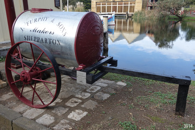 Flagstaff Hill Maritime Museum and Village
Vehicle - Furphy Water Cart, J. Furphy & Sons, c. 1942
This horse-drawn, two-wheeled cart with a tank, is known as a Furphy Farm Water Cart that was made in Shepparton, northern Victoria, c. 1942. John Furphy (1842-1920) was born in Moonee Ponds, in 1842 to Irish immigrant parents and subsequently raised in the Yarra Valley before the family moved to Kyneton in central Victoria, where he completed an apprenticeship with the firm Hutcheson and Walker. Murphy began operations of his own at a site on Piper Street in Kyneton in 1864. He relocated for a business opportunity and founded the first blacksmiths and wheelwrights shop in the newly surveyed town of Shepparton in 1873. Furphy invented many farming tools and machines including a patented grain-stripper, and won awards at the 1888-89 Melbourne International Exhibition. His most famous invention is the Furphy Farm Water Cart, designed in the 1880s, at a time when water for most households and farms was carted on wagons in wooden barrels. The Furphy’s water cart is a single item that combines a water metal tank and a cart. The design of the cart was simple yet effective, and became popular very quickly and established itself as a vital piece of farming equipment. The water cart has had a number of words cast into its ends over many years. References to the foundry’s location in Shepparton, as well as advertising of other products also manufactured by J. Furphy & Sons were present on the ends. However, the most significant set of words to feature on the tank, was a poem encouraging continual improvement: ‘Good Better Best, Never Let it Rest, Until your Good is Better, And your Better Best’. During The Great War (1914-1918), the water cart was used by the Australian militarily at a large AIF (Australian Imperial Force) camp in Broadmeadows (Melbourne) where thousands of men were camped for months, before being transported aboard. Furphy Water Carts provided water to the troops, and were usually placed near the camp latrines, which was one of the few places the troops could share gossip and tall tales away from the prying eyes and ears of their officers. The water cart drivers were also notorious sources of information, despite most of their news being hearsay, or totally unreliable. By the time the men of the AIF were in engaged in combat on the Gallipoli Peninsula and the Western Front, the carts used for water supply had no markings and became simply referred to as Furphys. This owed as much to the coining of the term ‘Furphy’, Australian slang for suspect information or rumour. After a number of decades as principally a soldier’s word, 'Furphy' entered the broader Australian vernacular and was used mainly by the political class until recently when the term was taken up by a Australian brewer as a beer brand. This Furphy Water Cart was purchased by Friends of Flagstaff Hill in 2014. The support of local individuals, organisations and businesses enabled its restoration and later its installation alongside the existing late-19th century water pipe stand and 1940s hand pump The Furphy Farm Water Cart is of historical significance as it represents a famous Australian time-saving and energy-saving invention of the 1880s, replacing the labour intensive activity of collecting and dispensing water from barrels and casks on the back of carts. The water cart’s connection with manufacturing companies J. Furphy & Sons and Furphy Foundry are significant for being early Australian businesses that are still in operation today. Furphy carts are of military significance for the role they played during The Great War (1914-1918) in Australian army camps, and theatres of war in Europe and the Middle East, to supply the AIF troops with fresh water. A wooden framed, two-wheeled, horse-drawn cart, fitted with a horizontally mounted, cylindrical metal tank. The tank is made of rolled, sheet steel with a riveted seam, and cast iron ends with cast iron ends. The spoked metal wheels have fitted flat iron tyres and metal hubs. A metal pipe is joined to the outlet. The tank is silver coloured, the ends, wheels and trims are crimson, and the script lettering on tank sides is black. There are inscriptions on the tank, ends, and hubs. The water tank was made in 1942 in Shepparton, Australia, by J. Furphy & Sons and has a capacity of 180 gallons (848 litres). Hub perimeter, embossed “J. FURPHY & SONS” “KEEP THE / BOLTS TIGHT” Hub centre embossed [indecipherable] Tank, each side, painted “J. FURPHY & SONS / Makers / SHEPPARTON” Tank ends, embossed – “FURPHY’S FARM WATER CART” “BORN ABOUT 1880 – STILL ‘GOING STRONG’ 1942” “j. FURPHY & SONS / MAKERS / SHEPPARTON - VIC “ “S - - - - - L MANUFACTURERS” [SPECIAL] “SPIKE ROLLERS” “SINGLE TREES” “PLOUGH WHEELS” “IRON CASTINGS” “LAND GRADERS” “STEEL DELVERS” “CAST IRON PIG” “CHAIN YOKES” “GOOD – BETTER – BEST / NEVER LET IT REST / TILL YOUR GOOD IS BETTER / AND YOUR BETTER – BEST” Image [Stork carrying a baby] above shorthand, transcribed "Produce and populate or perish" Image [Furphy Pig Feeder] beside ‘Cast Iron Pig’ Shorthand, transcribed “"Water is the gift of God but beer and whiskey are concoctions of the Devil, come and have a drink of water"warrnambool, flagstaff hill maritime museum, water cart, furphy cart, furphy tank, furphy farm water cart, furphy, john furphy, john furphy & sons, furphy foundry, kyneton, shepparton, mobile water tank, jinker, hutchinson & walker, blacksmith, farm equipment, implement maker, tool maker, horse drawn, stork and baby, good, better, best, barrel, tank, first world war, wwi, eastern front, gallipoli, j furphy & sons -
 Ballarat Tramway Museum
Photograph - Black & White Photograph/s, State Electricity Commission of Victoria (SECV), c1935
Set of 8 black and white photographs of the SEC Ballarat track welding truck, Reg. No. 119 341. Truck is a British Bedford truck, model WHG, built by GMH Melbourne between 1932 and 1934. Has a fabric roof, chassis fitted with a tray top body, side tool box, metal frame and covered with canvas, fitted out with a motor generator set, welding equipment and oxy acetylene bottles. Also fitted with a spot light - 'Auto Reel Lite". - See Related Items sheet on truck notes provided by Kevin Oates, MFESB workshops, 4/2001. (Scan of this sheet of the Kodak folder added 15-8-2017 - see pdf file.) 1705.1 - side on view of truck with covers down, except for opening at back. Photographed in Wendouree Parade with two different boat sheds in the background. 1705.2 - view with drivers side cover opened, showing equipment arrangement. 1705.3 - close up view of motor generator set and controls and one of the oxy acetylene bottles. 1705.4 - view showing equipment laid out on the roadway, welding cover, seat, grinder, cables, shovels, welding mask etc. 1705.5 - close up view of motor generator control panel and associated cables. 1705.6 - view of side of truck showing all equipment. 1705.7 - vertical format photo from rear of truck showing equipment laid out and wandering lead connected to the overhead. Also shows high voltage wires on a power pole fitted with a bracket arm. 1705.8 - view of truck from the front, with SEC symbol on side, with a covers closed. Thought to be photographed at loop in Wendouree Parade on the View Point line, near Mill St. Prints when donated to the BTM were contained within a red and yellow "Kodak" folder. Folder stored with catalogue worksheet. On rear of folder in ink is number "53569" and stamped on the front is number "984" and written in front top left hand cover, "8 prints" and in top right hand corner word "Sarah". See Notes provided by Kevin Oates of the MFESB (Metro Fire Brigade Melbourne) Thornbury workshops on the truck, manufacture and engine. A survey of Wendouree Parade on 22/4/2001 did not show the boat sheds or power lines featured in the photographed. Thought to be in vicinity of Power station because of the high voltage lines on the power poles.Stamped on rear in black ink, "984" on photos 1705.3 to 1705.8.trams, tramways, welding truck, trackwork, secv, wendouree parade -
4th/19th Prince of Wales's Light Horse Regiment Unit History Room
Specifications, Army Insignia, Badges and Buttons, 1951 - 1980
Set of manufacturing specifications for Australian Army insignia, badges and buttons - on foolscap in two lever arch files Specifications include: VOLUME 1 Badges, head dress & collar, AMF Insignia, shoulder, title, AUSTRALIA Insignia, metal, AUSTRALIAN ARMY Button, insignia, AMF Badge, metal, qualification, skill-at-arms Medallion & lapel badge, ANZAC commemorative Badge, lapel, metal, Army Reserve Lapel badge, Returned from Active Service Insignia, metal, Royal Cipher, Queen Elizabeth II Badge, metal, retired officers Button, insignia, general officer Link, button Insignia, metal, rank, womens, Warrant Officer & NCO tropical Insignia, metal, rank, officer, sword & baton crossed (1975) Insignia, metal, rank, officer, sword & baton crossed (1969) Insignia, metal, rank, officers, crown Insignia, metal, rank, NCO, crown Insignia, metal, rank, Warrant Officer, crown Palm leaf device for Vietnamese Cross of Gallantry Medal, service, Vietnamese campaign Button, insignia, Corps of Staff Cadets Insignia, metal, RAAC, beret/collar Insignia, metal, 1 AR, beret/collar Insignia, metal, 1/15 RNSWL, beret/collar Insignia, metal, 2 Cav, beret/collar Insignia, metal, 2/14 QMI Insignia, metal, 3 Cav, beret/collar Insignia, metal, 3/9 SAMR Insignia, metal, 4 Cav, beret/collar 4/19 PWLH Regt badge, head dress or collar Insignia, metal, 4/19 PWLH 8/13 VMR badges, head dress or collar Insignia, 10 LH, collar, silver plated 12/16 HRL, badges, head dress or collar Insignia, metal, RAA, officers, cap/hat, collar Insignia, metal, RAA, other ranks Button, insignia, RAA Button, insignia, RAE Insignia, metal, RAE cap/hat collar Button, Insignia, Royal Aust Survey Corps Insignia, metal, Royal Aust Survey Corps Insignia, metal, Royal Aust Corps of Signals, cap/collar Button, insignia, Royal Aust Corps of Signals Button, insignia, R Aust Inf Insignia, metal, R Aust Inf, cap/hat, collar Insignia, metal, Commando Insignia, metal, RSAR, cap/hat collar Insignia, metal, RAR, cap/hat collar Insignia, metal, RNSWR Insignia, metal, RVR, cap/hat Insignia, metal, RQR ,cap/hat collar Insignia, metal, RWAR, cap/hat collar Badge, qualification, Infantry Combat Button, insignia, Chaplains, Christian Insignia, metal, Chaplains, Christian, cap/hat collar Insignia, metal, RACT Button, insignia RACT Button, insignia, RAAMC Insignia, metal, RAAMC, cap/hat collarl, Insignia, metal, RAADC, cap/hat collar Button, insignia, RAAOC Insignia, metal, RAAOC' VOLUME 2 Button, insignia, RAEME RAEME, badges, collar Insignia, metal, R Aust Army Educational Corps, cap/hat collar Button, insignia, AACC Insignia, metal, AACC, cap/hat collar Button insignia, R Aust Army Pay Corps Insignia, metal, R Aust Army Pay Corps, cap/hat collar Insignia, metal, Aust Army Legal Corps, cap/hat collar Insignia, metal, R Aust Army Provost Corps, cap/hat collar Button, insignia, R Aust Corps of MP Button, insignia, Aust Army Psych Corps Insignia, metal, Aust Army Psych Corps Button, insignia, Aust Army Nursing Corps Insignia, metal, R Aust Army Nursing Corps Button, insignia, WRAAC Insignia, metal, rank, mess undress, brooch type, RAAMC Insignia, metal, WRAAC Insignia, shoulder, Apprentice Insignia, metal, Army Apprentices School Button, insignia, OCS Button, insignia, OCS ,blazer Insignia, metal, OCS, cap/hat collar Button, insignia, RMC, blazer Insignia, metal, RMC Medallion, RMC Insignia, metal, AUR, cap/hat collar Button, insignia, MonUR Insignia, metal, MUR, cap/hat collar Button, insignia, MonUR Insignia, metal, MonUR, cap/hat collar Insignia, metal, UNSWR , cap/hat collar Insignia, metal, SUR, cap/hat collar Button, insignia, SUR Insignia, metal, QUR, cap/hat collar Button, insignia, QUR Insignia, metal, WAUR, cap/hat collar Button, insignia, WAUR Badge, metal, qualification, flying, Army pilot, Aust Army Aviation Corps Insignia, metal, Aust Army Aviation Corps Button, insignia, Aust Army Aviation Corps Badge, metal, qualification , bandsman Badge, metal, qualification, Drum Major Button, insignia, Aust Army Band Corps Insignia, metal, Aust Army Band Corps, cap/hat collar Rubber stamp of Engineering Design Establishment giving conditions of issue to contractorsspecifications -
 Flagstaff Hill Maritime Museum and Village
Photograph - Portrait, David Charles McArthur, Superintendent, Bank of Australasia 1867-1876, 1970s
The subject of this photograph, David Charteris McArthur was the founding manager of the Bank of Australasia in Port Phillip (Melbourne). McArthur was born in 1808 in Gloucester, England, and educated in Scotland. He worked for an insurance firm in Edinburgh where in 1835 he married Caroline nee Wright. McArthur and his family party sailed from the U.K. to arrive in Sydney in October 1835, where he joined the Bank of Australasia when it opened in Sydney in December. McArthur sailed to Melbourne in August 1838 with 3000 pounds in coins, protected by armed guards and two bulldogs, to open the Melbourne branch of the Bank of Australasia. The branch grew quickly, servicing both private and government customers. He opened many branches in the goldfields during the1850’s. In 1862 he was appointed as general inspector of branches. He spent time with the bank in New Zealand. On his return to Melbourne, at age 57, he was put in charge of the entire bank. McArthur lived in the hills of Heidelburg, Melbourne. He was the first chairman of Associated Banks and was advisor to politicians and merchants. He was retired in October 1876 by the London directors and given a free trip to London, an annuity and a seat on the bank’s Advisory Board. McArthur was active in the community, being a member of the Mechanics’ Institute, on the committee that advised Governor Hotham on the Colony’s finances, chairman of the Heidelburg Road Board, one of the original trustees of the Library of Victoria in 1853 and president of trustees of the Public Library, Museums and National Gallery of Victoria in 1880-83. He was also on many other community organisations. He died in his home “Charterisville” in East Ivanhoe in 1887. He and Caroline had no children. The Melbourne branch of Australia and New Zealand Bank has a portrait of McArthur in its boardroom. St John's Church, Heidelberg, commemorates him with a stained-glass window entitled 'King David'. The McArthur Gallery in the National Gallery of Victoria is also named after him. (David's brother, Donald, moved from Sydney to Melbourne in 1836 with the first government survey team.) ABOUT THE BANK OF AUSTRALASIA In 1836 the Bank of Australasia was established in London by Royal Charter. In 1951 the bank merged with the Union Bank of Australia, to form ANZ Bank Limited. In 1970 it merged with the English, Scottish and Australian Bank to become Australia and New Zealand Banking Group Limited. Since that time the ANZ has acquired other banks and introduced Internet banking and mobile banking. BANK OF AUSTRALASIA IN WARRNAMBOOL The Bank of Australasia first opened in Warrnambool in July 1854 in a building on Merri Street. The manager was Mr Samuel Hannaford. The bank then purchased and moved to a stone building on the corner of Timor and Gibson Streets, previously owned by Cramond and Dickson and almost opposite the Examiner’s office. In January 1957 Mr W.H. Palmer became the new manager and was there until November 1869. The bank then built its own building on the corner of Timor and Kepler Streets in 1859. Mr Basil Spence, the teller, was appointed acting manager in 1869 and Mr H.B. Chomley was the next appointed manager, in April 1873 and was still manager in 1886. The municipality of Warrnambool first banked with the Bank of Australasia from 1856 to April 1857. David Charteris McArthur was the founding manager of the Bank of Australasia. This photograph of him represents the beginnings of Warrnambool's commercial history, with the municipality using the Bank of Australasia as its bank from 1856-April 1857.Photograph; portrait of David Charteris McArthur. Heavily retouched black and white print in plain brown varnished frame, behind glass, with plaque on lower edge and inscription lower left corner.Lower left corner "A-H 1-9". Engraved on plaque "DAVID CHARTERS MCARTHUR \ SUPERINTENDENT \ BANK OF AUSTRALASIA \ 1867-1876"flagstaff hill, warrnambool, shipwrecked-coast, flagstaff-hill, flagstaff-hill-maritime-museum, maritime-museum, shipwreck-coast, flagstaff-hill-maritime-village, bank of australasia, david charteris mcarthur, superintendent bank of australasia, colonial commerce, manager bank of australasia melbourne, colonial bank, warrnambool bank of australasia, shipwrecked coast, flagstaff hill maritime museum, maritime museum, shipwreck coast, flagstaff hill maritime village, great ocean road, boa, union bank, australia & new zealand bank, anz bank, david charters mcarthur, d c mcarthur -
 Warrnambool and District Historical Society Inc.
Documents, Childer's Cove, 1920-1940's
Childers Cove is situated about 15 ks east of Warrnambool in the area known as Mepunga. It is named after the shipwreck of 'The Children.The documents relate to the running of the Childer's Cove Progress Association. There are a number of social activities including gymkhanas, racing meetings, making of roads and improving with planting trees There are many names which are still familiar with the area nearly 100 years later, including Wallace, McDowall, Burleigh, Murnane, Bonnett, Abraham Laidlaw Keogh Holloway and Palmer. Some of the meetings were held at the Mepunga South School with others held at Eckers Hotel Warrnambool and some at the race course. Fundraising events were held also from athletic meetings and district school children's races. This collection of papers is representative of many small communities around Australia where people came together and worked to improve their community facilities. It therefore has strong social and historic significance.This is a collection of papers most of which relate to the Childer's Cove Progress Association. Included are: .1 Minute Book/ Exercise book Childer's Cove Progress Association.May 1928-1932 .2 Minute Book/ Exercise book Childer's Cove Progress Association. 1924-1926 .3 Letter from Warrnambool Football Club 1930. .4 Account Archibald MacFarlane & Co March 1929 .5 Western District Racing Association Oct 1929. .6 Federal Taxation Dep Re Entertainment Tax 11/02/1930 .7 Chief Secretary Office re Racing Permits March 1923. .8-.9 Warrnambool Standard Invoices Jan 1930's .10 Archibald MacFarlane & Co Jan 1930. .11 Chief Office for Stamp Duties 12/02/1928 .12 Flyer - Childer's Cove Progress Association April 17 1926. .13 Flyer- Monster Gymkhana 12/02/ 1927. .14 Handwritten Invoice Charles Palmer Nov 1929. .15 Cheque Book Childer's Cove Progress Association 1929-31. .16 Deposit Book Childer's Cove Progress Association 1932-1942 .17 Bundle of invoices. .1 C J Caddy & Sons.2 Western Ice & Ice Products .3 Department of Lands & Survey Aug 1923 .4 J S Tait re Licence April 1924 .5 Warrnambool Standard31/12/1923 .6 Warrnambool Standard 31/03/1924 .7 Devenish & Co August 1924 .8 Warrnambool Standard 31/06/1924 H J Paynter & Co 03/05/1924 .10 Chief Secretary's Office Melbourne 01/05/1924 with receipt. .11 Permit for a race meeting April 19 1924 .12 Commonwealth of Australia Entertainment Tax 06/09/1924.13 Commonwealth of Australia Entertainment Notice 27/08/01924 .14 Commonwealth of Australia Entertainment Tax notice 12/08/1924 .18 William Ardlie handwritten letter 28/03/1928 .19 Envelope Addressed to W R Abrahams .20 Final notice Handwritten Charles Palmer Jan 1930. .21 Balance Sheet Childer's Cove Racing Club 18/03/1929 .22 H J Paynter & Co Account and receipt 25/02/1930. .23 Raglan Parade Timber Yards Alex Donaldson Feb 1930. .24 The School Paper Feb 1964 No 741 childer's cove, mepunga, childer's cove progress association -
 Conservation Volunteers
Award: Honour Roll, United Nations Environment Program (UNEP) - 1 June 2000 - The UNEP announced that the Australian Trust of Conservation Volunteers of Australia (ATCV), has been elected to the prestigious ranks of its Global 500 Roll of Honour for outstanding contributions to the protection of the environment, Award:United Nations Environment Program (UNEP) - 1 June 2000 - UNEP announced today that the ATCV has been elected to the prestigious ranks of its Global 500 Roll of Honour for outstanding contributions to the protection of the environment
THE AUSTRALIAN TRUST OF CONSERVATION VOLUNTEERS, ONE OF 14 INDIVIDUALS AND ORGANIZATIONS, TO RECEIVE UNITED NATIONS ENVIRONMENT AWARD NAIROBI, 1 June 2000 - The United Nations Environment Programme (UNEP) announced today that the Australian Trust of Conservation Volunteers of Australia (ATCV), has been elected to the prestigious ranks of its Global 500 Roll of Honour for outstanding contributions to the protection of the environment. ATCV is one of 14 individuals and organizations to receive this honour in 2000. Founded in 1982, ATCV is a national, not-for-profit community organization, whose mission is to attract and manage a force of volunteers in practical conservation projects for the betterment of the Australian environment. ATCV completes more than 4000 week-long conservation projects in urban, regional and remote areas of Australia each year. Activities range from bush regeneration, tree planting, seed collection, endangered species protection, weed control, flora and fauna surveys, walking trail construction, fencing, environmental monitoring and the protection of world heritage areas. ATCV community participation has resulted in more than 1.8 million trees being planted in 1999, and in more than 7.3 million trees planted over the past 10 years. Community involvement totalled 200,000 project days in 1999 and more than 700,000 days since 1989. To encourage the involvement of young people, ATCV developed and manages the federal government-funded programme Green Corps. Green Corps is a six-month traineeship for 17 to 20 year-olds, which incorporates conservation projects and accredited training. Since 1997, more than 4,000 trainees have completed the Green Corps programme. ATCV is a founding member of the International Conservation Alliance, which brings together organizations working in conservation volunteering, and is a member of the World Conservation Union (IUCN). " The award will be presented in Adelaide, Australia, at the World Environment Day ceremonies on 4 June 2000. World Environment Day, which is celebrated in some 120 countries around the world on 5 June, was established by the United Nations General Assembly in 1972 to focus global attention and action on environmental issues. Some 701 individuals and organizations, in both the adult and youth categories, have been honoured since UNEP launched the Global 500 award in 1987. Among prominent past winners are: French Marine explorer Jacques Cousteau; Sir David Attenborough, producer of environmental television programmes; Gro Harlem Brundtland, former Prime Minister of Norway; Anil Aggarwal, the prominent environmentalist from India; Ken Saro-Wiwa, the environmental and human rights activist from Nigeria who was executed for leading the resistance of the Ogoni People against the pollution of their Delta homeland; the World Wide Fund for Nature (WWF), Jimmy Carter, former President of the United States; Jane Goodall of the United Kingdom whose research on wild chimpanzees and olive baboons provided insight into the lives of non-human primates; and the late Chico Mendes, the Brazilian rubber tapper who was murdered during his fight to save the Amazon forest. To forge global links and to implement ideas, which can contribute to a more sustainable future, a network of all Global 500 laureates has been formed. Information about this unique network can be obtained at http://www.global500.org. The winners of UNEP's Global 500 Roll of Honour are members of a broad and growing environmental movement that is flourishing around the world. They have taken the path that most of us hesitate to take for want of time or caring," says UNEP's Executive Director, Klaus Toepfer. "In honouring the Global 500 laureates, UNEP hopes that others will be inspired by their extraordinary deeds."Certificatecva, conservation volunteers, conservation volunteers australia, conservation volunteers new zealand, colin jackson, better earth, environmental conservation, volunteers, volunteering, corporate volunteering, education – environmental, carbon footprint, climate change, ballarat, safety, training, partnerships, victoria, vic, nsw, queensland, act, australian capital territory, nt, northern territory, western australia, wa, south australia, sa, tasmania, new zealand, california conservation corps, atcv, unep, unep honour roll, united nations environment program -
Port Fairy Historical Society Museum and Archives
Photograph, Mason, John
Captain John Mason came from Stirling in Scotland, arriving at Port Fairy in 1844. One year after James Atkinson obtained his Special Survey of the area. Thus his life covers all the history of Port Fairy when it was known as Belfast. He married Jane Murray in Portland in 1846 and they had 5 children, Jane died in 1855 and ten years later he married Ann Brown widow of Abijah Brown. They had no children and she died in 1887. In due course he became known as Captain Mason, he was not a sea captain, but captain of the Belfast Volunteers, a Rifle Corps formed in 1859 as a consequence of the Crimean War, and later reconstituted as the Belfast Volunteer Corps. For 40 years he displayed a remarkable versatility in his various occupations. Starting as an Innkeeper - he took over the Stag Inn from Captain Saunders in 1852, for 3 years. He then became a carpenter, stonemason, architect, estate agent honorary technical advisor to the Borough and treasurer to the Shire, and Savings Bank Secretary. They thought so well of John mason in Belfast that they elected him to the first Roads Board in 1853 and to the first Municipal Council in 1856. He was Chairman four times and with Councillors David Talbot and Joseph Whitehead designed the Council's Common Seal and the Motto "Commune Bonum".He was the first Mayor of the Borough in 1863 for a period of 7 weeks. He was responsible for the design, supervision or construction of many of the buildings in the town; most still standing today. He built the Rosebrook Bridge in 1855 and the first official Post Office ( a timber structure in Bank Street) in 1857, replacing it with a stone office in 1865. he built the Court house in 1859 and completed the breakwater between Rabbit Island and Griffith Island started by James Atkinson and John Griffith in 1849, also the first bridge over the Moyne river which connected with Battery Lane and the Bay. Among the many buildings associated with John Mason are Gobles Mill, Tynemouth Villa, 10-12 Princes Street, the Mechanics Institute, the Commercial Hotel, Yambuk and Mickey Bourke's Pub in Koroit. However, he did not build "Riverdale" in Gipps Street as is thought. He had a store and workshop on this site but sold the property in 1872 before the house was built. After an almost uninterrupted term as Councillor starting with the Municipality in 1856, John resigned from the Council in 1873. He well deserved the illuminated address they gave to him and the toast that they drank in the Bank Hotel champagne. Within the year he was working for the Borough as its engineer., surveyor, general supervisor and advisor of public works, simply as the man to whom all difficult problems were referred and at very little expense. John Mason was a great worker for his town and devoted himself unsparingly to the community. That his work was appreciated was shown by the way in which people rallied to his aid when, in the end, he found himself in financial difficulties and his reputation was challenge; arrested for embezzling from the Savings Bank of which he was the actuary in 1882. The money was repaid and the charges found not proven at his trial. He was an early member of the Loyal Prince Albert Lodge, and a founding member of the smaller Loyal Belfast Lodge in 1863. He was also a member of the Horticultural Society. Captain John Mason Died on the 14th of October 1891 (see also 62-04-046 photo)Sepia photograph on heavy cardStevenson & McNicoll photo. 108 Elizabeth Street Melbourne copies can be obtained at anytimedefence, captain, mason, carpenter, councillor, mayor -
 Flagstaff Hill Maritime Museum and Village
Rangefinder, E R Watts & Sons, 1930-1945
E. R. Watts and Son, makers of theodolites and other surveying instruments, of 123 Camberwell Road, London. The company was established in 1856 by Edwin Watts at twenty-three he had saved £100 from his earnings to start the business with his staff consisting of one boy and later Alexander Clarkson as an apprentice with the workshop a small room over a Bemondsey stable. Watts' first order was from Negretti and Zambra for a mining dial Alexander Clarkson In the early days the firm worked mainly on marine compasses. Edwin Watts would go down to the Docks to adjust the compasses once they had been installed on the ships. In May 1873 the business moved to larger premises a house with a garden. The workshop was also the home of Mr and Mrs Watts and their five sons and three daughters. By now there were fifteen to twenty men employed by the firm. The company were commissioned to supply the Theodolites and Levels for the construction to the Canadian Pacific Railway in 1881. Towards the end of the century, the firm began to make heliographs continuing to produce them for the government until just before the Second World War when by agreement assigned their manufacture to another firm. 1904 The first dividing engine was completed by George William Watts. It was so remarkable an instrument at the time and for years afterwards, In 1907 Arthur Ames went to Canada and started an organisation in Winnipeg in 1909 this became a separate company called E. R. Watts and Son Ltd. of Ottawa. This firm developed considerably and was eventually with the co-operation of three other instrument companies (Cambridge Instrument Co, Ross, and Negretti and Zambra), were reconstituted as ”Instruments Ltd” of Ottawa and Toronto. During the next ten years, the firm expanded greatly to include glass grinding, leather work, dividing and engraving, testing, adjusting and packing. This expansion was continued during the First World War when workshops were completed and the machinery installed and running within eleven weeks from the start of construction. During the war, a Sergeant Coles, among the rats, lice and mud of the trenches, fitted various bits of scrap into his cocoa tin and made the first Flash Spotter for plotting the positions of enemy guns. Coles was rushed home to the firm's factory where he and George William Watts designed a spotter not made out of a cocoa tin and as a result, the Watts Vertical Force Variometer was developed during WWI. Other Watts instruments made in the First World War included the Light Mountain Theodolites which were taken on Mt Everest expeditions. In 1919 ER Watts and Sons was incorporated as a limited company and in 1939 G. A. Whipple joined the Board of Directors. Shortly afterwards, Frank Charles Watts died having been Chairman of the firm for over 37 years and seen it through the First World War with all its expansions and difficulties. He was succeeded by his brother George William Watts with the vacant post of Managing Director being filled by G. A. Whipple. During the Second World War, the company expanded further and the number of employees rose to well over 1,300. In 1946 Watts acquired 78% of Adam Hilger and the microscope maker James Swift and Son Who were Manufacturers of Theodolites, Levels, Alidades, Meteorological Instruments, Variometers, and many other types of scientific instruments Then in 1948 the company amalgamated with Adam Hilger as Hilger and Watts which was then incorporated as a public company.Naval Rangefinder with a vertical wooden handle, and an arrangement of optical lenses. Three reversible brass inserts calibrated on both sides in yards, correspond to various base heights, (20 and 25 feet, 30 and 35 feet and 40 and 50 feet). They are fitted along the axis of the instrument. When the scale for the appropriate base height is selected and inserted, the carriage can be slid for coincidence and the distance read at the index mark on the sliding carriage.inscribed "Rangefinder Cotton Type Mk II" Calibrated scale up to 5000 yds (50 ft), 5000 yds (35 ft), 4000 yds (25 ft) made by E. R. Watts & Son.flagstaff hill, warrnambool, shipwrecked coast, flagstaff hill maritime museum, maritime museum, shipwreck coast, flagstaff hill maritime village, great ocean road, rangefinder, cotton type, e r watts & sons, naval range finder, marine equipment