Showing 10533 items
matching lander
-
 Bendigo Historical Society Inc.
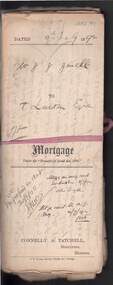
Document - CONNELLY, TATCHELL, DUNLOP COLLECTION: MORTGAGE MR. J.J. JEWELL TO T. LUXTON ESQ
Documents relating to mortgage between Mr. Joshua James Jewell of Mitiamo, farmer, and Mr. T. Luxton , The Exchange, Collins St., Melbourne for land at Parish of Terrick Terrick West, County of Gunbower, mortgage document dated 4th. July 1892. Contains 3 Conditions of Sale documents, newspaper clipping re clearing sale of 2600 acres of land on behalf of Mr. J.J. Jewell, farming implements, machinery, household effects at 'The Hill' Mitiamo.. Letters relating to transactions re above mortgage enclosed, including discharge of mortgage handwritten document between Sarah Berges and Joshua J. Jewell. Note name change from Connelly & Tatchell, to Connelly, Tatchell & Paling. Letter enclosed in file from Mr. Joshua Jewell, 'The Hill' Mitiamo, Oct 4th., 1893 to Mr. T, Luxton, requesting ' waiting another (?) for money I will be able to pay it before the month is up but at present I cannot meet it. I have just commenced to shear and of course money will be coming in now'cottage, miners, joshua james jewell, thomas luxton, terrick terrick west, gunbower, mortgage, connelly, tatchell & paling, s. berges, connelly, tatchell & dunlop, paling. -
 Victorian Aboriginal Corporation for Languages
Book, Hetti Perkins, Crossing country : the alchemy of Western Arnhem Land art, 2004
Hetti Perkins introduces this collection of reproductions of of Western Arnhem Land bark paintings, rock art, woven fibre art and wooden sculpture that was exhibited by the Art Gallery of NSW in 2004, emphasising the cultural foundations of the Kuninjku artists, their beliefs, artistic conventions and innovations. The book includes interviews with traditional rock and bark artists (including some language), and essays describing the connection of the people to the land, their spiritual beliefs and their art. There are also reproductions of works on paper and woven forms and an essay on the role of women in producing these art forms. An essay by Professor Jon Altmann is entitled "Brokering Kuninjku Art: Artists, Institutions and the Market. A chronolgy details the history of aboriginal art in the area, there are biographies of the artists whose works were included in the exhibition, a list of the works themselves, a glossary of place names, art terms, aboriginal, linguistic and anthropological terms, and a select bibliography. The list of contributors includes, as well as the two mentioned above, Dr Murray Garde, Apolline Kohen, Steven Miller, Cara Pinchbeck and Dr Luke Taylor.Colour photographs -
 Glen Eira Historical Society
Plan - Warrigal Road, Oakleigh
Documents about a small portion of land on Warrigal Road Oakleigh, now Oakleigh East. A Letter dated 29/05/1952 from Gas and Fuel Corporation of Victoria to Mr. L.P. Simmonds requesting valuation of land for proposed widening of Warrigal Road. A plan of Survey, no.5474, for Crown portion of Parish of Moorabbin and Parish of Mordialloc for owner The Brighton Gas Coy Ltd. New Street Brighton. Mortgages to the National Mutual Life Association. A letter dated 04/06/1952 from Gas and Fuel Corporation of Victoria in reference to Warrigal Road and Centre Road from the Country Roads Board who desire to acquire the land. Handwritten calculation notes and price for valuation, most likely as an attachment to the letter dated 04/06/1952.gas and fuel corporation, warrigal road, centre road, moorabbin council, simmonds l.p, survey plan, county of bourke, the brighton gas company ltd., country roads board, the national mutual life association of australia ltd., bentleigh east -
 Warrnambool and District Historical Society Inc.
Document - Warrnambool City Council Preliminary Report Industrial Estate West Warrnambool, E Johnson, 9 March 1973
This preliminary report relates to 32½ acres of council owned land in West Warrnambool bounded on the North by McMeekin Road, on the East by Scott Street, on the South by Evans Street and on the West by the rear boundaries of properties facing Landmann and Granter Streets. In 2010, West Warrnambool was the largest of Warrnambool’s existing industrial areas, comprising approximately 109ha of industrial zoned land, the majority of which (101ha) is zoned IN1Z, with the remainder zoned INZ3. The area comprises a mixture of lot sizes supporting a diverse mix of industries. Larger parcels are occupied by the abattoirs, scrap metal industries, freight, the Council Depot and storage. Smaller lots are occupied by smaller manufacturers and wholesalers and service industries. [Ref: Warrnambool Industrial Land Use Review. Mesh Pty Ltd July 2010]This document is a preliminary report prepared by the Warrnambool City Council Engineer in March 1973 and provides an example of the planning process undertaken to develop one of Warrnambool's industrial areas. It contains details and costings of the proposed subdivision. Two foolscaps size pages of typewritten information. A detailed topographical map of the area with areas highlighted in blue, red, green, blue and purple pen.warrnambool city council, west warrnambool, industrial estate -
 Greensborough Historical Society
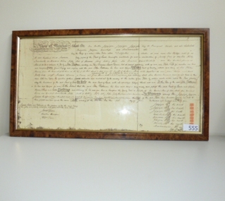
Document (Framed), Batman's Treaty of Melbourne, 06/06/1835
John Batman recorded in his journal that he had signed a treaty with the local Aboriginal people, the Wurundjeri to buy 2,000 km of land around Melbourne and another 400 km around Geelong. In exchange he gave the eight chiefs whose marks he acquired on the treaty, a quantity of blankets, knives, tomahawks, scissors, looking-glasses, flour, handkerchiefs and shirts. Under British law, the treaty was legally invalid as the land belonged to the Crown, not to the Wurundjeri. Although the treaty was declared null and void by Governor Bourke within six months of John and Henry Batman and the Port Phillip Association organising this treaty, it remains an interesting part of Melbourne's early history. Copy of Batman's Treaty of Melbourne, 1835. Original hand written on parchment in triplicate. john batman, wurundjeri, treaty of melbourne, melbourne history, batman's treaty -
 Eltham District Historical Society Inc
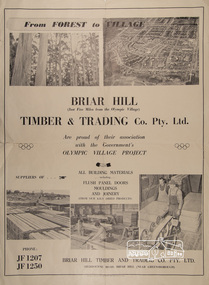
Poster, Briar Hill Timber & Trading Co. Pty. Ltd, c.1956
Advertisement insert in The Age newspaper around the opening of the 1956 Olympic Games promoting Briar Hill Timber's association with the Olympic Village Project being suppliers of all building materials including Flush Panel Doors, Mouldings and Joinery. Briar Hill Timber owned by F. Squire and the Squire family owned a lot of land around Briar Hill and land for forest at Flowerdale. Operations ranged from logging of trees, to milling to manufacture of joinery and housing frames.Poster approximately A2 in sizebriar hill timber, f. squire, olympic village, 1956 olympic games, timber mill, flowerdale, briar hill, h.v. plowman, logging, advertisement -
 Eltham District Historical Society Inc
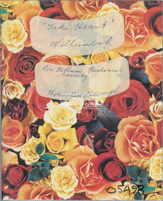
Album - Photo Album, Ruth Pendavingh, Take Heart, Nillumbik, 1998-2002
Album of photographs associated with activities of the Cardiac Rehab "Take Heart" Group including the Arthritis Group (Land and Water exercise) managed by Eltham Community Health Centre allied health assistant, arthritis group (land and water exercise), arthritis group, arthurs creek, betty willis, bundoora park, cardiac rehab 'take heart' group, christmas break-up, diamond valley railway, dirk pendavingh, elizabeth dick, eltham community health centre, eltham health group, eltham leisure centre, eltham lower park, eltham, ernie robinson, fairfield park, fairfield, flagstaff hill, griffiths park, ken willis, lavender farm, migrant teachers, mt cooper, new eltham diabetes contact group, parkinson support group, picnic, ruth pendavingh, scienceworks, sugarloaf reservoir, veronica white-hall, warringal, water exercise group, warrrnambool, warrnambool rsl -
 Eltham District Historical Society Inc
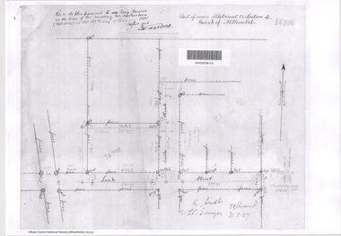
Document - Photocopy, Survey Fleld Notes of Part of Crown Portion 13, Section 4 at Eltham, Parish of Nillumbik, County of Evelyn, 31 May 1907
Portion of land east of Main Road and north of Luck Street bounded by Bible Street Application 36708 K. Arndt, Licensed Surveyor, 31 May 1907application 36708, bible street, eltham, luck street, main road, map, survey plan -
 Eltham District Historical Society Inc
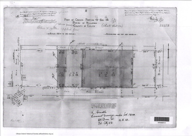
Document - Photocopy, Survey Fleld Notes of Part of Crown Portion 12, Section 4 at Eltham, Parish of Nillumbik, County of Evelyn, 12 October 1910
Portion of land bounded by: Main Road, John Street, Bible Street, Pitt Street Application 38858 K. Arndt, Licensed Surveyor, 12 August 1910application 38858, bible street, eltham, john street, main road, map, pitt street, survey plan -
 Eltham District Historical Society Inc
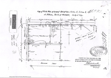
Document - Photocopy, Survey Fleld Notes of Part of Crown Portion 12, Section 4 at Eltham, Parish of Nillumbik, County of Evelyn, 30 September 1925
Portion of land bounded by: Main Road, Franklin Street, Bible Street, Brougham Street Application 46839 R. Woodcock, Licensed Surveyor, 30 September 1925application 46839, bible street, brougham street, eltham, franklin street, main road, map, survey plan -
 Eltham District Historical Society Inc
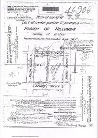
Document - Photocopy, Survey Fleld Notes of Part of Crown Portion 12, Section 4 at Eltham, Parish of Nillumbik, County of Evelyn, 18 March 1926
Portion of land bounded by: Main Road, York Street, Bible Street, Bridge Street Application 46906 R.H. Woodcock, Licensed Surveyor, 18 March 1926application 46906, bible street, bridge street, eltham, main road, map, survey plan, york street -
 Eltham District Historical Society Inc
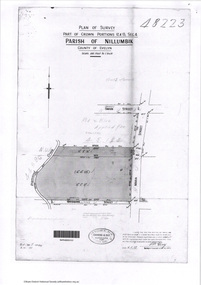
Document - Photocopy, Survey Fleld Notes of Part of Crown Portions 12 & 13, Section 4 at Eltham, Parish of Nillumbik, County of Evelyn, 6 May 1929
Portion of land bounded by: Main Road, York Street, Diamond Creek, Swan Street Application 48223 P.N. Guy, Licensed Surveyor, 6 May 1929application 48223, diamond creek (creek), eltham, main road, map, survey plan, swan street, york street -
 Eltham District Historical Society Inc
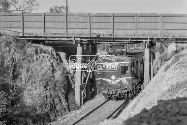
Photograph, George Coop, A Hurstbridge bound Harris (Blue) train passes underneath the Silver Street railway overpass at Eltham, March 1980, 1980
The Harris trains operated in Melbourne 1956-1988. They were full of asbestos and were taken out of service, wrapped in plastic and buried in land fill near ClaytonDigital TIFF file Scan of 35mm Kodak Safety 5063 black and white transparencyharris (blue) train, eltham, silver street, overpass -
 Greensborough Historical Society
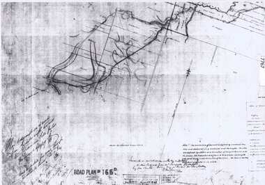
Document - Road Plan, Road acquisition, St Helena Road, 1859, 1889
Road plan showing land acquisition for the road to Diamond Creek (NOT Diamond Creek Road), also known as Eltham Road and now known as St Helena Road.Shows the land through which St Helena Road runs, with original owners marked on plan.1 page. Copy of road planroad plans, st helena road greensborough, diamond creek -
 Greensborough Historical Society
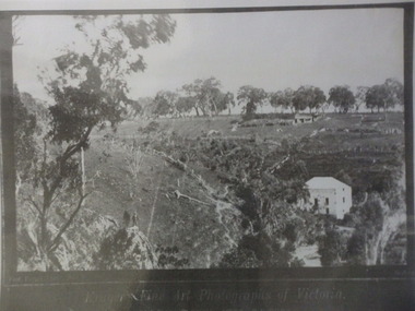
Photograph (copy), Fred Kruger, On the Plenty River near Bundoora / photograph by Fred Kruger, 1877c
View of farm land and mill on the Plenty River near Bundoora, circa 1877; photograph by Fred Kruger. Original held at SLV (accession # H473 and Image # a53840)Black and white photograph, enlarged and laminated.fred kruger, plenty river -
 Greensborough Historical Society
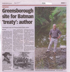
Newspaper - Newspaper Clipping, Heidelberg Leader et al, Greensborough site for Batman "treaty": author, by Rick Koenig, 2017_02
Jim Poulter's research indicates that the accepted account of Batman's Treaty with aboriginal elders regarding purchase of the land of Melbourne is not true. He claims the Treaty was signed in Greensborough.Newspaper clipping, text and images. Date written in black ink: "Feb 2017"john batman, batmans treaty -
 Greensborough Historical Society
Article, Avril Salter, Yallambie Homestead, by Avril Salter, 1970_
This history of Yallambie Homestead was written by Avril Salter in 1970. It covers the property since its original land grant, to the homestead until and after its alteration in 1923. A history of one of the areas homesteads which is still in use today.Research article, 43 pages, text only. Photographs which accompanied the original text were lost.yallambie homestead, yallambie, avril salter -
 City of Moorabbin Historical Society (Operating the Box Cottage Museum)
Flyer - Eldon Court, Moorabbin
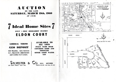
In the mid 1900's land sales in Moorabbin began of the remaining market gardens which were being sub divided. Eldon Court was auctioned off in 1960Example of the progress of the Municipality of MoorabbinPhotocopy of advertising flyer for auction of real estate sales - plan of building blocks for saleEldon Court, Moorabbin - 7 Home sites - Saturday March 19 1960eldon court, moorabbin, real estate, auction -
Tatura Irrigation & Wartime Camps Museum
Photograph - copy, copy 1989
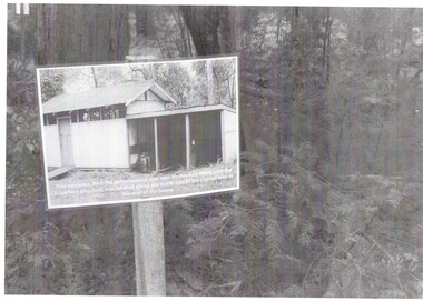
WW2 internment camp 1, Tatura, was built on land owned by Mr J. B. Noonah and consisted of mainly German internees. A large and modern hospital was located there. Black and white photograph of hospital site sign. No. 3 Internment campon back. Remains of hospital site, internment camp no. 3.internment camps, tatura internment camps, j. b. noonan, german internees -
 Tatura Irrigation & Wartime Camps Museum
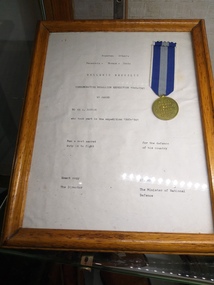
Certificate - Certificate of Gratitude, Certificate of Gratitude to Mr A Ransom
The certificate of gratitude was present to Mr A Ransom by the Greek Government. It was awarded to Australian servicemen who served in Greece against overwhelming number of German air and land troops.Piece of white paper with black writing, enclosed in a brown wooden frame. Attached to document is a bronze medal with a stripped ribbon. One band of navy blue, one band of light blue and one band of navy blue.certificate of gratitude, mr a ransom, greek government, australian servicemen, greece, german air and land troops -
 Katandra and District History Group
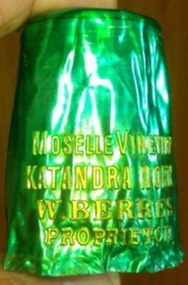
A Wine Bottle Cover, early 20th century
W. Berres winery located at Katandra North early 20th century .The land was later taken over by Vic. government for soldier settlement.This is a small remenant of the winery.Wine bottle cap cover green with gold letteringmoselle vineyard katandra north w berres proprietorw.berres vineyard -
Lakes Entrance Regional Historical Society (operating as Lakes Entrance History Centre & Museum)
Photograph, 1915 c
Shed behind workers in clad and roofed with bark sheets held in place with horizontal timbers. The contractor with steam engine travelled around the district as requested by land ownersBlack and white photograph of fire workers baling hay using small steam engine to power the baler on a farm in East Gippslandagriculture -
 Whitehorse Historical Society Inc.
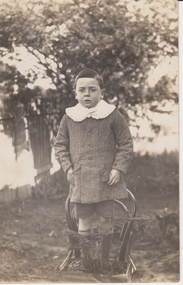
Photograph, James Hansen, 1916
James Hansen was adopted by Francesca and Louis Schwerkolt. When Francesca died she left him two blocks of land and a house in Deep Creek Road Mitcham.Black & white photograph of James Hansen, fostered son of Francesca Schwerkolt. He is standing on a chair, is dressed in a coat and short pants and is wearing a white collar.Jimmy Hansen c1916hansen james, schwerkolt francesca -
 Kew Historical Society Inc
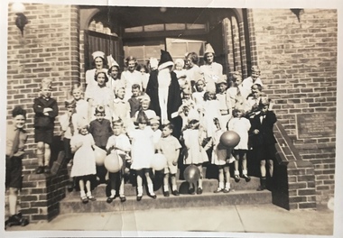
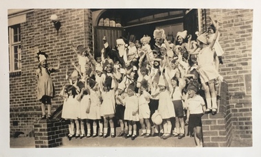
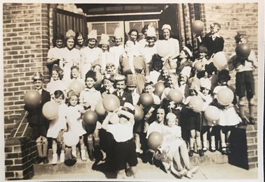
Photograph - St Hilary's Church Christmas Party, c.1932
St Hilary's Anglican Church in Kew was established in 1888 on land granted to the congregation by the Dumaresq family. The brick building shown here replaced an earlier wooden structure.Small black and white photographic positive, one of four, of a Christmas party for children at St Hilary's Church, 12 John Street, Kew. The children, surrounding an adult Santa Claus, are dressed in festive costumes and a number carry balloons. The foundation plaque is on the wall to the children's left. The photo was tentatively dated to 1932 by the donor. Inscribed verso: "St Hilary's Christmas Party ?1932"churches -- kew (vic.), st hilary's church -- kew, anglican churches -- melbourne (vic.) -
 Kew Historical Society Inc
Photograph - St Hilary's Church Christmas Party, c.1932
St Hilary's Anglican Church in Kew was established in 1888 on land granted to the congregation by the Dumaresq family. The brick building shown here replaced an earlier wooden structure.Small black and white photographic positive, one of four, of a Christmas party for children at St Hilary's Church, 12 John Street, Kew. The children, surrounding an adult Santa Claus, are dressed in festive costumes and a number carry balloons. The photo was tentatively dated to 1932 by the donor. Inscribed verso: "St Hilary's Christmas Party ?1932"churches -- kew (vic.), st hilary's church -- kew, anglican churches -- melbourne (vic.) -
 Kew Historical Society Inc
Photograph - St Hilary's Church Christmas Party, c.1932
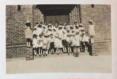
St Hilary's Anglican Church in Kew was established in 1888 on land granted to the congregation by the Dumaresq family. The brick building shown here replaced an earlier wooden structure.Small black and white photographic positive, one of four, of a Christmas party for children at St Hilary's Church, 12 John Street, Kew. The children are formally dressed with most wearing hats. The photo was tentatively dated to 1932 by the donor. Inscribed verso: "1932 St Hilary's Christmas Party"churches -- kew (vic.), st hilary's church -- kew, anglican churches -- melbourne (vic.) -
 City of Kingston
Pamphlet - Colour, Stillwell and Co, The Hill Estate Highett Great Subdivisional Auction Sale, 1917
Sales plan for land in the suburb of Highett, bounded by Point Nepean Road and incorporating Sandford Street, Turner Road, Alfred Street, Peace Street and Tennyson Street. .The developing urban area of Highett within the City of Kingston. This land sale pamphlet illustrates the subdivision of land within the municipality and the changing demographic of the district as new houses are constructed.Colour pamphlet advertising subdivisional auction sale of the Hill Estate Highett. Incorporates a map of the estate bordered by Point Nepean Road and encompassing Sandford Street, Turner Road, Alfred Street, Peace Street and Tennyson St. Handwritten in grey pencil on reverse: Hill Street / Jamieson Handwritten in blue pencil on reverse: The Hill Estate Handwritten in blue pencil on subdivision map: [tick] [on majority of properties marked on map]highett, land sales, estate -
 City of Kingston
Pamphlet - Colour, W. H. Wood Estate Agent, Realising sub-divisional auction sale Bentleigh Park Estate, Bentleigh, 1920
Sales plan for land in the suburb of Bentleigh, bounded by Centre Road, and incorporating subdivisions on either side of Elizabeth Street (Wheatley Road), Oak Street and Beech Street.The developing urban area of Bentleigh within the City of Kingston. This land sale pamphlet illustrates the subdivision of land within the municipality and the changing demographic of the district as new houses are constructed close to infrastructure.Colour pamphlet advertising a realising sub-divisional auction sale of the Bentleigh Park Estate, Bentleigh. Incorporates a map of the estate bordered by Centre Road, and including Elizabeth Street (Wheatley Road), Oak Street and Beech Street.Hand drawn in grey pencil: a small square on subdivision 33 Hand drawn in grey pencil: a small square incorporating a cross on subdivision 24 Hand written in black ink on reverse: Bentleigh Park / Estate / Ward late Andersonsland sales, estate, bentleigh -
 Whitehorse Historical Society Inc.
Photograph - Black and white Digital Copy, Wandinong Sanctuary
The house and land on the corner of Canterbury Road and Ronley Street Blackburn was donated to Nunawading Council by Janet and Arthur Hooke upon their deaths as a permanent bush area for the public.Two digital copies of a function at Wandinong Blackburn.janet hooke, arthur hooke, wandinong sanctuary