Showing 27796 items
matching yarra-river
-
 Marysville & District Historical Society
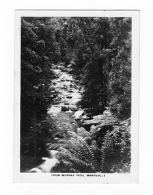
Photograph (item) - Black and white photograph, Rose Stereograph Company, From Murray Pass, Marysville, 1913-1967
An early black and white photograph of the Taggerty River from Murray Pass near Marysville, Victoria.An early black and white photograph of the Taggerty River from Murray Pass near Marysville, Victoria. Murray Pass is off the Lady Talbot Drive. Lady Talbot Drive a 24 kilometer scenic rainforest car journey which passes a number of walks and waterfalls in the Yarra Ranges National Park. Lady Talbot Drive is named after Lady Sarah Elizabeth, the wife of Sir Reginald Talbot, who was the Governor of Victoria from 25th April, 1904 to 6th July 1908.The photograph was also used to produce the Rose Series postcard P. 2309.marysville, victoria, photograph, taggerty river, murray pass, lady talbot forest drive, p. 2309, rose series postcard, souvenir, rose stereograph company, sir reginald talbot, lady sarah elizabeth talbot -
 Marysville & District Historical Society
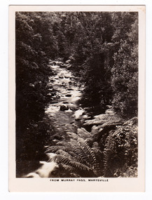
Photograph (item) - Black and white photograph, Rose Stereograph Company, From Murray Pass, Marysville, 1913-1967
An early black and white photograph of the Taggerty River from Murray Pass near Marysville, Victoria.An early black and white photograph of the Taggerty River from Murray Pass near Marysville, Victoria. Murray Pass is off the Lady Talbot Drive. Lady Talbot Drive a 24 kilometer scenic rainforest car journey which passes a number of walks and waterfalls in the Yarra Ranges National Park. Lady Talbot Drive is named after Lady Sarah Elizabeth, the wife of Sir Reginald Talbot, who was the Governor of Victoria from 25th April, 1904 to 6th July 1908.The photograph was also used to produce the Rose Series postcard P. 2309.marysville, victoria, photograph, taggerty river, murray pass, lady talbot forest drive, p. 2309, rose series postcard, souvenir, rose stereograph company, sir reginald talbot, lady sarah elizabeth talbot -
 Flagstaff Hill Maritime Museum and Village
Photograph - Vessel - steam launch, Mrs. A. Dawson, Lady Loch, Feb 1907 - Jun 1910
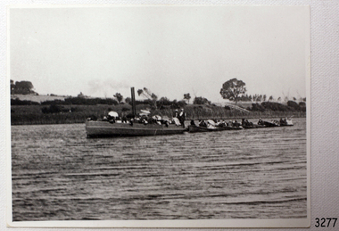
The photograph shows the steam launch Lady Loch towing five rowing boats full of passengers on the Hopkins River at Warrnambool. The boat is travelling downstream from the riverbank near Jubilee Park towards Warrnambool and the river mouth. A similar trip in 1909 was a fund-raising excursion when the Lady Loch was to tow boats from Flett & Sons' boating establishment on the Hopkins River, travelling towards Jubilee Park. The photograph was taken between February 1907 and June 1910 by Mrs A. G. Dawson from the Hopkins River Bank at “Allandale”, which she was leasing. She took another photograph that day, which was published in the Warrnambool Standard on 24th March 1973. At the time of the photograph the launch Lady Loch was owned by James Flett & Son who operated a boatshed on the bend of the Hopkins River. The boat was described as “a fine little steamer”. In 1916 it was licenced to carry 42 passengers. The LADY LOCH: - In February 1884 Mr Sutton’s steam launch had the name of Lady of the Lake. The boat was part of the entertainment for a Sunday school picnic at Ballarat Lake and Gardens. In October 1884 Mr Ivey from Lake Wendouree purchased two vessels, the steamer Ballarat and Mr Sutton’s well-known and popular launch, Lady of the Lake, to join his own fleet of pleasure boats. In November 1887 Mr Mark Hooper’s purchase of a ‘new’ pleasure boat, Lady of the Lake, arrived in Colac to be an addition to his boating business. The launch had been transported by road from Ballarat, but the boiler and the engine had travelled by rail the previous day. In June 1888, Fanny Nelson purchased the steam launch Lady of the Lake for her Nelson’s Boating and Fishing Establishment on the Hopkins River, Warrnambool. She renamed it Lady Loch. People have suggested the mane was in honour of the wife of the then-current Governor of Victoria, Sir Henry Loch, and the local paper stated that Lady Loch flew the Governor’s colours of yellow, black and blue on her first trip under Nelson’s ownership, Sunday 12th August 1888. In 1890 Fanny Nelson sold her complete business, including Lady Loch, to Mr Chapman. in January 1897 James Flett & Sons, already involved in boating, purchased the business from Chapman. In January 1916, Flett advertised everything for sale, including the boatshed and the steam launch Lady Loch. NOTE: - at least three vessels in Victoria were named Lady Loch; a river launch (ca 1884-ca 1916), a steamer ferry (1884-1920s) and a government steam lighthouse tender HMS Lady Loch (1886-1962)The photograph of the Lady Loch pleasure steamer represents the social and recreational activities of late 19th-century people from Warrnambool and the local district. It shows an example of the pleasure craft of that era. The history of the Lady Loch includes the history of fishing and boat hire businesses of that period. The photograph is also connected with an early Warrnambool buat builder James Flett & Sons. representing the maritime history of the town.Photograph, black and white, of the steam launch Lady Loch towing five rowing boats downstream on the Hopkins River from Jubilee Park towards the river mouth. There are many figures on the boats. The photograph was taken from a property called Allandale on the south river bank between February 1907 and June 1910. The photographer was Mrs A. G. Dawson. The Lady Loch was owned by Mr James Flett & Sons at that time. The photograph is mounted on card.flagstaff hill, warrnambool, shipwrecked-coast, flagstaff-hill, flagstaff-hill-maritime-museum, maritime-museum, shipwreck-coast, flagstaff-hill-maritime-village, lady of the lake, lady of the lake steamer, lady loch steamer, lake colac steamer, hopkins river warrnambool, jubilee park warrnambool, francis maria mann, andrew abernathy nelson iiird, hopkins hotel, nelson's boathouse, chapman's boathouse, flett's boathouse, fanny (francis) nelson, james flett & sons -
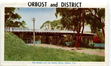
 Orbost & District Historical Society
postcard, C1920-1940
This photograph shows the second major bridge across the Snowy River at Orbost. The current Snowy River bridge is the fourth to provide a crossing to the township of Orbost. The first, in 1891, lasted just two years before it succumbed to flood waters. The bridge in this photograph was built in the 1920s as a road and rail bridge, and was again partly washed away by flood waters in 1934. After the end of the first World War the Victorian Railways considered an extension of the railhead across the river at Orbost, and in 1922 a new timber and steel girder structure, a joint Country Roads Board — Victorian Railways venture, was built and completed at a cost of £41,000 (the steel girders came from the Flinders Street viaduct reconstruction). Subsequently it was decided not to take the railway across the river, and the bridge was only used by road traffic. It was severely battered by floods during its life. and after the 1971 floods was eventually replaced by the current bridge in 1975. (info from Newletter 54N by John Phillips) This item is an early pictorial record of the previous Snowy River bridge at Orbost.A postcard with a black / white photograph of a bridge - timber and steel girder structure - across the Snowy River at Orbost, Reflections of the bridge are seen in the water.snowy-river-bridge-orbost -
 Ringwood and District Historical Society
Book, Diane Baird, Digging Into History - Goldmining in Warrandyte, 2007
Information about early mining in Victoria's first gold field. Cover photographs: Front cover - Fossickers working below the water-wheen driven stamper battery located on the south side of the Yarra River upstream of the Warrandyte Bridge. Back cover - The Old Post Office, Warrandyte, in 1906, now the premises of the Warrandyte Historical Society Museum and Archive, 111 Yarra Street.Acknowledgements: Several members of the Warrandyte Historical Society were involved in the development of this publication. It was developed and written by Diane Baird; Murray Houghton and Ted Rotherham provided specialist historical details and further references; Jo Laurence and Shirley Rotherham collected and identified photographs; Brian Laurence prepared images for electronic format; and Richard Morton edited and formatted the text. The Society gratefully acknowledges the dedicated work of all its members who collect, preserve and share Warrandyte's history. In particular, the research by the late Bruce Bence and the dedicated work of the late Jo Laurence have been an invaluable contribution to the history of Warrandyte. -
 Uniting Church Archives - Synod of Victoria
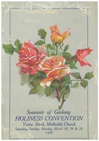
Program, Souvenir of the Holiness Convention, 1939
The convention was held in the Yarra Street Methodist Church, Geelong on the 18th, 19th, 29th June 1938. It was arranged and convened by the Methodist Local Preachers' Association.Souvenir program for the 23rd Holiness Convention. The program is pale green with a painting of four red and orange roses on its cover. Front cover: "Souvenir of Geelong HOLINESS CONVENTION Yarra Street Methodist Church, Saturday, Sunday, Monday March 18,19 & 20 1939"" methodist local preachers' association melbourne branch, yarra street methodist church, geelong -
 Port Melbourne Historical & Preservation Society
Photograph - Double-sided aerial photograph, Hobson's Bay and the Yarra River/Port Phillip and Western Port Bay, Surveyor General and Director of Mapping, Apr 1990
Landsat imagery - an extract from the atlas of VictoriaAerial photos of Port Phillip and Western Port (double sided aerial photographs). 1995 side A: Hobson's Bay and Yarra River - aerial photo mosaic; side B. Port Phillip and Western Port Bays - satellite photo.port of melbourne authority -
 Melbourne Tram Museum
Negative, Wal Jack, 10/02/1941 12:00:00 AM
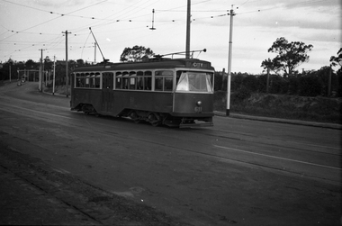
Black and white negative, by Wal Jack, of No.Y1 611 inbound in Swan St Richmond or Burnley after crossing the Yarra River bridge. Photo dated 10-2-1941 in the Wal Jack album along with details of the location.trams, tramways, swan st, y1 class, burnley, tram 611 -
 Melbourne Tram Museum
Negative, Wal Jack, 1/09/1941 12:00:00 AM
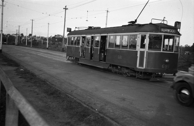
Black and white negative, by Wal Jack, of CW5 681, (Burwood, Route 74) in Swan St Burnley, prior to crossing the Yarra River. Photo dated 1-9-1941 in the Wal Jack album along with details of the location.trams, tramways, burnley, cw5 class, swan st, route 74, tram 681 -
 Kew Historical Society Inc
Photograph - Victorian Canoe Club, Dight's Falls, Studley Park, 1920-30
Canoeing on the River Yarra at Melbourne was an important and widespread recreational pursuit for Melbournians, especially in the first half of the twentieth century. The Victorian Canoe Club was formed in 1912 at a meeting in Melbourne and its first committee elected in the same year. Records indicate that the Club continued into at least the 1950s .The album has historic and social significance as a record of recreational activities (as well as canoe making) in the early years of the twentieth century. It has local significance as the site of the headquarters of the Club was in Studley Park. A number of photographs in the album provide vistas of Kew on the Yarra that are otherwise unavailable.One of 24 labelled photos in part album, originating from the Victorian Canoe Club, which had its headquarters in Studley Park, Kew. The album includes a photographic record of canoe construction and also locations in Studley Park and Kew where the canoes were used. The subject of this photograph is identified as 'Dight's Falls, Studley Park'.The view is from above and shows an early trestle bridge across the Falls on which people, possibly members of the Club, are walking or standing. The point of view would appear to be looking up river towards Fairfield."Dyghts Falls, Studley Park"victorian canoe club, river yarra, burke road -- kew (vic.), dight's falls -- fairfield (vic.), dight's falls -- kew (vic.), dight's falls -- yarra river -
 Running Rabbits Military Museum operated by the Upwey Belgrave RSL Sub Branch
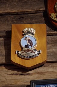
Plaque HMAS Yarra
HMAS Yarraplaque, ran -
University of Melbourne, Burnley Campus Archives
Photograph, James Leslie Provan, Burnley 1942 Album Page 1, 1942
Yarra Boulevard.yarra boulevard, burnley, 1942, j.l. provan -
![Decorative object - PLATE, FORD, RICHARD MR. [DICK]](/media/collectors/510b3f7f023fd725b4cd5256/items/58b6364390751a35b421d95e/item-media/665d18e0b11434ddaeb8b29e/item-fit-380x285.jpg) Clunes Museum
Clunes MuseumDecorative object - PLATE, FORD, RICHARD MR. [DICK]
.1 PAINTING OF ORIGINAL CRESWICK HOSPITAL ON CERAMIC PLATE, THEN GLAZED. .2 PAINTING OF MOUNTAINS, RIVER AND COTTAGE.1 CREAM COLOURED CERAMIC CIRCULAR PLATE, PAINTING OF ORIGINAL CRESWICK HOSPITAL. .2 CREAM COLOURED CIRCULAR PLATE OF MOUNTAIN AND RIVER SCENE.local history, ornament, ceramic -
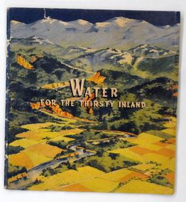 Orbost & District Historical Society
book, Water For the Thirsty Inland, 1945
Water For the Thirsty Inland was published by The Murrumbidgee Valley Water Users Association as a case for diversion of part of the Snowy River waters to the Murrumbidgee. In 1950 The Murrumbidgee Valley Water Users Association and the League established the Murray-Murrumbidgee Development Committee to ensure the Snowy Scheme was completed.This book is a significant research tool for the history of the diversion of the Snowy River.A 44 pp book, titled Water For The Thirsty Inland. On the front cover is a coloured print of a painting of a river (Snowy River?) from the mountains to the flats. The text of the title is white with a black shadow. The book contains b/w photographs and the print is black and green.Some pencilled notes on back.snowy-river murrumbidgee-valley-water-users' irrigation -
Peterborough History Group
Newspaper articles pertaining to Peterborough from 1990 to 1999
Various newspaper articles kept by Mrs Dawn Irvine, all pertaining to Peterborough - river flooding and quality, concerns over council boundary realignment. Article titles: 6/10/1992 Flooding at Peterborough 28/6/1994 Residents undecided over River 4/7/1994 Letter from Warren Moore. Peterborough is alive, the way residents like it. 26/12/1994 Letter from R. Irvine. Apprehension over changes 17/6/1998 Algae fear prompts call to open Curdies River 13/4/1999 Battlelines on the Curdies 14/4/1999 Peterborough residents urge BHP to find alternative waste disposal optionHistoric overview of the towns' concerns at that time. Seven newspaper cuttings of various sizes all regarding aspects of Peterborough. Includes objection to BHP discharging waste into the Curdies River and flooding. warren moore, ronald irvine, curdies river, moyne council, council boundary realignment, curdies river flooding, floods, peterborough, blue green algae, river quality, bhp waste management, bhp -
 Marysville & District Historical Society
Photograph (item) - Black and white photograph, Unknown
An early black and white photograph of a man attempting to repair the tree bridge which once traversed the Steavenson River at the base of Steavenson Falls.An early black and white photograph of a man attempting to repair the tree bridge which once traversed the Steavenson River at the base of Steavenson Falls. The Steavenson Falls is named after the Victorian Assistant Commissioner of Roads and Bridges, John Steavenson who arrived in Victoria in the early 1860s.steavenson falls, steavenson river, marysville, victoria, waterfalls, john steavenson -
 Port of Echuca
Black and white photograph, 21.09.1984
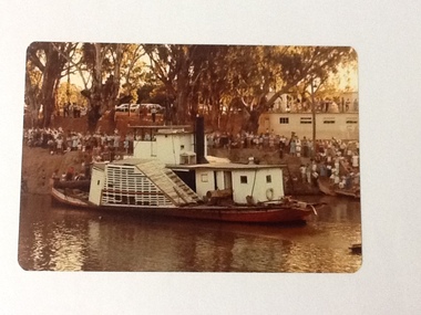
Black and white photograph of the P. S. Gem moored by the river bank. Recorded as being holed on Mildura slip. For statistical on the P. S. Gem see registration no.10 from The River trade, Wool & Steamers by G. Painter , pp.55, 66. Details of the paddle steamer can be located in The Register of Australian & N. Z. Shipping.The P. S. Gem is a large paddle steamer of historical and social significance. It has 3 levels including what appears to be many cabins.Black and white photograph of P. S. Gem moored by river bank. Recorded as being holed on Mildura slip. Copy of an original photograph taken 1954.On reverse of photo in pencil: Gem 1954, holed on Mildure slip.p. s. gem, mildura slip -
Tatura Irrigation & Wartime Camps Museum
Photograph, State Rivers and Water Supply Commission, 1957
This photograph was taken for the State Rivers and Water Supply Commission - for display purposes.Large sepia photograph dry mounted to cream board. Sign board with Engineer Ron Dickson looking at sign on left of photographState Rivers and Water Supply Commission / Goulburn Irrigation System / Enlargement and Remodelling Project / Design and Construction Depot / Enquiries at General Office.irrigation, victoria state rivers and water supply commission, ron dickson -
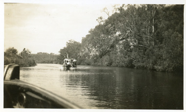
Lakes Entrance Regional Historical Society (operating as Lakes Entrance History Centre & Museum)
Photograph, 1940 c
Also a second black and white photograph of Peels launch Zephyr in Tambo River with Swan Reach bridge in background 05099.1Black and white photograph of Peels launch Zephyr filled with passengers moored at landing place on Tambo River near bridge at Swan Reach Victoriaaccidents, transport, roads and streets -
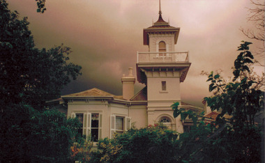 Kew Historical Society Inc
Photograph - 'Swinton', 23 Swinton Avenue, 2000
Swinton is of significance as one of the earliest examples of the use of the Italianate in Australian domestic architecture, and for the elegance of its design, particularly in the tower.Original colour positive photograph of the west elevation of Swinton, 23 Swinton Avenue, Kew. Facade facing Yarra River featuring tower and balcony with door and fanlight below. Projecting bay window at left. Rendered brick with slate roof. Ink on reverse: "Swinton - west elevation / Feb 2000"swinton, swinton avenue -- kew (vic.) -
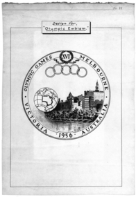 Federation University Historical Collection
Poster, Design for "Olympic Emblem" Melbourne, 1956, c1956
The Olympic Games was held in Melbourne in 1956.White poster with black text and images. The poster shows an image of Melbourne buildings on the Yarra River, with a work globe featuring the outline of Australia. The poster also shows the olympic rings and relates to the 16th Olympic Games held in Melbourne in 1956.melbourne olympic games, melbourne, olympic games, poster -
 Sunbury Family History and Heritage Society Inc.
Photograph, 27 June 1934
This is a photograph of the bridge in the Bulla township which spans the Deep Creek, a tributary of the Maribyrnong River. It has been constructed from bluestone which is found across the volcanic western plains in Victoria. Kaolin was quarried from the cliff face in the background and was used in the making of bricks and pottery products manufactured at Northcote and Brunswick potteries.This is one of the many notable bluestone bridges which were built in the district in the nineteenth century.A black and white photograph of a valley with a five arched bridge spanning a river. There are high cliffs in the background.bulla township, deep creek, bridges -
 Port of Echuca
Photograph - Black and white photograph, 19/09/1984
A copy of the original photo held by J. Norris of Butcher St, Echuca, of the P.S Oscar W towing the P.S Gem from Mildura to Swan Hill believed to be in 1930. This towing only got as far as the Bitch 'n Pups. The Oscar W was built in Echuca in 1908 by Captain Franz Wallin, who was also it's first owner. He named it after his son Oscar who had been killed in the Boer War. In 1919 he sold the Oscar W to the Permewan Wright Co. In 1942 it was sold to Captain G. Ritchie who took it to Goolwa. After a busy working life along the Murray River, the P.S Oscar W returned to Goolwa in 1988 where it remains to this day. This picture is significant as it shows a large paddle steamer towing another large paddle steamer in a high river. It shows the river level in 1930, as well as how collaborative life on the river needed to be in those circumstances. A black and white photograph of the P.S Oscar W towing the P.S Gem en route from Mildura to Swan Hill on the Murray River in a high river level.Written on the back of the photo in lead pencil, "Oscar W towing Gem to Swan Hill.. Only got to Bitch 'n Pups en route from Mildura." Norris Collection.echuca boat building, goolwa, south australia, wallin , oscar, murray river, wallin, franz, 1930, high river levels, norris family collection, p.s oscar w, bitch n'pups murray river, p.s gem -
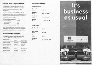 Melbourne Tram Museum
Pamphlet - PTC split, Public Transport Corporation (PTC), It's business as usual, 9/1997
Gives details of the split of the tram division of the Public Transport Corporation Vic to come into effect on 1-10-1997 into two business divisions - Yarra Trams and Swanston Trams. Includes a map showing which entity was to operate what section of Melbourne Trams. Prepared for employee information. Provides information on who would be the senior managers, a timetable, depots and routes to be operated and the logos that would be used.Yields information about the split of the Public Transport Corporation Tram division in preparation for the future privatisation. Pamphlet - photocopy titled Pamphlet - It's business as usual about the split up of the PTC to Swanston Trams and Yarra Trams. Two copies held.trams, tramways, yarra trams, swanston trams, ptc, managers, depots, public transport corporation -
 Orbost & District Historical Society
postcard series, 1960s
Included are photographs of the Orbost township, the Snowy River at Marlo, Gypsy Point, Buchan Caves and Bairnsdale. In the 1960s Orbost had a population of 4000 and was a major tourist attraction in Eastern Victoria with sufficient accommodation and facilities. It was the major town close to several national parks with access to either the surf or the snow. These postcards are pictorial records of Orbost in the 1960s. Postcards are very interesting records of places. architecture and transport.A colour postcard series with photographs of Orbost and the district. The cover photograph is of the Snowy River Bridge. There is an information card.Each photograph is labelled. at the bottom.postcards-orbost postcards-east-gippsland -
 Lakes Entrance Regional Historical Society (operating as Lakes Entrance History Centre & Museum)
Photograph, 1950 c
Road between Swan Reach and Tambo Upper follows river bank opposite cliffsBlack and white photograph print showing tourist launch, possibly 'MV Blackbird' on Tambo River below the cliffs, taken from another boat. Tambo Upper Victoriajetties, waterways, boats and boating, tourism -
 Marysville & District Historical Society
Photograph (item) - Black and white photograph, Unknown
An early black and white photograph which shows a man and a woman standing on the bridge that crosses the Steavenson River at the base of the Steavenson Falls in Marysville in Victoria.An early black and white photograph which shows a man and a woman standing on the bridge that crosses the Steavenson River at the base of the Steavenson Falls in Marysville in Victoria. The Steavenson Falls are named after the Victorian Assistant Commissioner of Roads and Bridges, John Steavenson who arrived in Victoria in the early 1860s.steavenson river, steavenson falls, marysville, victoria, waterfalls, john steavenson -
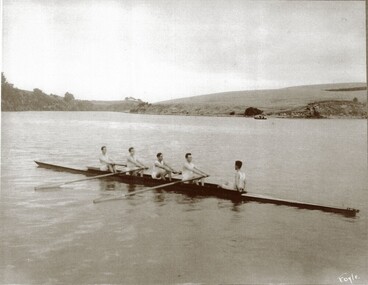 City of Warrnambool Rowing Club
Photograph
The photograph is of the 1925 Warrnambool Rowing Club Lightweight four- they raced at the clubs annual Boxing Day Regatta. H Sherriff was stroke J MacNamara (3 seat) C Earls (2 seat) L Halliwell (bow), T Fary was cox. The Regatta that year had three events and the other usual aquatic events were cancelled due to poor weather. Mr W. A. Hope was regatta secretary. It is recorded on page 109 of the 1914-35 minute book that 'Mr. Meckin, the president, said he had much pleasure in moving a motion of long salutation to the light weight four in recognition of the fine performance they put in at the Yarra Yarra and Albert Park Regattas...Mr. Hope seconded and added...credit to the crew..a fine lesson to some of the older members in perseverance..'Black and white photograph of a Warrnambool Rowing Club crew of 5 in a rowing boat on the Hopkins River, Warrnambool. Taken in 1925. Under the photograph is the name of the crew and year it was taken: Lightweight fours 1925 H Sherriff stroke J MacNamara C Earls L Halliwell bow T Fary coxrowing, warrnambool rowing club, hopkins river, city of warrnambool rowing club -
 Port of Echuca
Colour Photograph, 04/03/1983
Colour photograph of the P. S. Adelaide in the river, with the port side of the boat clearly visible. The bank behind and the roof of the boat shed at Paddlewheel park are lined with spectators. Final part of the photo sequence of the event no.:P000041; P000045; P000046; P000047; P000048 of the P. S. Adelaide re-floating.The re-floating of the P. S. Adelaide was a Significant community social event evident by the number of spectators in the photograph. The community had invested a great deal of time and money into re-floating the paddlesteamer. The newspaper covered the event in detail with a number of action shots as the boat made its rear entry from the temporary slipway onto the river. Part of a photo sequence no.P000041; P000045; P000046; P000047; P000048 of P. S. Adelaide re-floating.Colour photograph of P. S. Adelaide on the Murray river at Echuca after her re-floating. The port side of the Adelaide is clearly visible. The banks of the river are lined with spectators. The pontoon boat shed at Paddlewheel Park is visible on the right, also has spectators on the roof platform.p. s. adelaide, re-floating p. s. adelaide, echuca -
 Orbost & District Historical Society
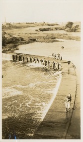
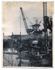
black and white photographs, 1975
These are photographs of the construction of the current cement road bridge across the Snowy River at Orbost. Construction of the bridges commenced in January 1975, with an expectation to open the bridge across the Snowy River as soon as possible. Less than two years later, on 25 November 1976, the bridge across the Snowy River was opened to traffic, allowing the old bridge to be demolished. The remainder of the Orbost Bypass, both the floodplain crossings and the eastern section around the township itself, was declared ‘Princes Freeway’ and opened to traffic in December 1977. (ref http://mrv.ozroads.com.au)The opening of this Snowy River Bridge was an important development in the accessibility to the township of Orbost. These photographs record its construction.Two black / white photographs showing the construction of a road bridge across a river. 3257.1 shows piles being dropped beside the bridge, 3257.2 is of the early stages of construction of this bridge.snowy-river-bridge-orbost road-construction-orbost bridge-orbost