Showing 5241 items
matching drawn-thread
-
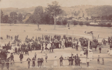 The Beechworth Burke Museum
Postcard, 1908
Printed in 1908, the postcard depicts a public gathering at Baarmutha Park, Beechworth on Boxing Day the same year. There are many men, women and children dressed in formal attire including suits and hats. A large number of women are holding parasols. Multiple horse-drawn carts are visible throughout the image.The record is historically significant due to its production in the very early twentieth century. This significance is enhanced by its contextual information, as the record provides insight into the social and leisure activities enjoyed by people at Baarmutha Park during this time.Sepia rectangular postcard printed on card.Obverse: BAARMUTHA PARK, BEECHWORTH. BOXING DAY, 1908. / Reverse: Parks & Gardens. / POST CARD. / KODAK / CORRESPONDENCE. / ADDRESS ONLY. / AUSTRAL / AUSTRAL / KODAK / (?) Craig / Stanley / 3747 / 9/ - Boxing Day / Sports Baarmutha / Park Beechworth / 84-148-1 / GARDENS / 97.2335 / 79.21.9 /entertainment album, baarmutha park, beechworth, 1900s, social, leisure, gathering, horses -
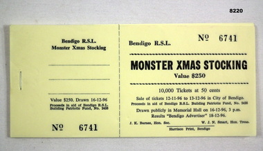 Bendigo Military Museum
Financial record - XMAS STOCKING TICKETS BRSL 1996, C. 1996
These tickets were sold from 12.11.1996 - 13.12.1996 and drawn on 16.12.1996 with the results in the Bendigo Advertiser on 18.12.1996. The proceeds of this yearly effort was in aid of the Bendigo RSL Patriotic Building Fund. These raffles are believed to have began pre 1950 and ran until 1999. Refer Cat No's 8130P and 8221.Book of raffle tickets, yellow colour stapled in lots of twenty, tickets are in two sections, tear off for purchaser, and but for drawing the raffle, tickets are 50 cents each, stocking value $250.00, 10,000.00 tickets, these are ticket No's 6741 - 6760"Bendigo R.S.L. Monster Xmas Stocking"brsl, smirsl, xmas, stocking, 1996 -
 Creswick Campus Historical Collection - University of Melbourne
Artwork, other - Lithograph, Acacia Longifolia (c1880) Artist, Rosa Fiveash, Acacia Longifolia, 1882-1890
Acacia Longifolia (Willdenow) (Labillardiere). The Maritime long-leaved Wattle C1880. Artist- Rosa Fiveash (1854 � 1938). Drawn on stone by H.B. (H. Barratt) Lithographed by E. Spillar. Lithograph printed in colour, from multiple stones on paper. Mounted in wooden frame with Acorn engraved motif.Early museum photographs. Documents from Parks Victoria.. In 1882 Rosa was invited to illustrate The Forest Flora of South Australia by John Ednie Brown. Nine parts of this work, which was never completed, were published in 1882-90. Each one contained five attractive lithographs of native plants and Rosa drew 32 of the 45 published; they were drawn as specimens came to hand, in no particular botanical order(second. http://adb.anu.edu.au/biography/fiveash-rosa-catherine-6184Lithograph -
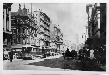 Melbourne Tram Museum
Photograph - Black and White - Elizabeth Street looking south from
Photo of the view looking south to Flinders Street Station, shows a number of motor vehicles and horse-drawn vehicles, along with a motor cycle with a sidecar and one cable tram set hauling a bogie trailer. Note the road surface which appears to be damaged by vehicles. There are a number of puddles showing. Yields information about the view looking south in Elizabeth St. c1920Black and White - Elizabeth Street looking south Little Collins Street, c1920. tramways, trams, cable cars, elizabeth street, traffic, horse drawn vehicles -
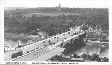 Melbourne Tram Museum
Postcard, Rose Stereograph Co, "Princes Bridge and Government House Melbourne", mid 1930s
Rose Series postcard No. P 10650 titled "Princes Bridge and Government House Melbourne", looking southeast from Flinders St Station clock tower. Has three W2 class trams, (One at Batman Ave terminus), two buses and some horse-drawn vehicles in the view.,Yields information about St Kilda Road, mid 1930s.Postcard - printed real photograph with Rose Stereograph Co. name on the rear. Two copies held.trams, st kilda road, princes bridge, government house, w2 class, st kilda rd, tramways -
 Ballarat Tramway Museum
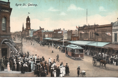
Postcard, R.E.M Series Melbourne, "Ryrie St., Geelong", c1912
Postcard produced by REM Melbourne, printed in Saxony of a view of Ryrie St Geelong looking west. Has tram No. 7 in the view, a horse drawn cart and a large crowd looking on - opening day or a test tram? In the view are E Gurr Real Estate, Allans, and the Geelong Town Hall.Yields information about Ryrie St Geelong c1912.Colour Postcard divided back, unused.Has the Ken Magor stamp on the rear.tramways, trams, geelong, ryrie st, tram 7 -
 Melbourne Tram Museum
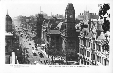
Postcard, Rose Stereograph Co, "The Town Hall Swanston Street Melbourne", c1900
Rose Series postcard No. P 588 titled "The Town Hall Swanston Street Melbourne", looking north along Swanston St. Has at least eight cable tams in the view, along with many horse-drawn vehicles. The building on the right is the Queen Victoria Building on the corner of Collins Street. Yields information about Swanston St and the Melbourne Town Hall, c1900Postcard - printed real photograph with Rose Stereograph Co. name on the rear.trams, tramways, swanston st, cable trams, melbourne town hall, collins st -
Ballarat Tramway Museum
Legal record, City of Ballaarat, City of Ballaarat - by-law - No. 120, June 1939
By-Law No. 120, details the regulation or control of traffic, motor vehicles and horse drawn, pedestrians in the City of Ballaarat, including tram stops and safety zones. Dated 19/6/1939. Signed Alex M King Mayor, J Pryor Councillor and Geo F Morton Town Clerk.Yields information about the operation of vehicles in Sturt St. Ballarat at the time when Councils were responsible for traffic control within their municipalities.Folded sheet - 8 pages printed centre stapled. Two copies, includes one marked reprint.tramways, city of ballaarat, sturt st, two way traffic, traffic control -
 Ballarat Tramway Museum
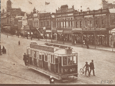
Photograph - Illustration/s, ESCo 21, Grenville St
Tram has the destination of City. Has 1920 in bottom rh corner. Cut from a magazine. Has photos of warehouse on rear, with horse drawn carts & motor vehicle. Sepia toned. See also Reg item 5143 for another version of this image and 9465 for a glass plate negative.Yields information about the ESCo Sebastopol type electric trams and the streetscape in central Ballarat 1920.Small clipping of ESCo tram No 21, arriving Grenville Street. 1920 in pencil on right hand bottom cornertrams, tramways, sturt st, grenville st, sebastopol type, esco -
 National Wool Museum
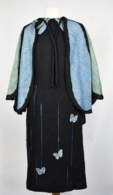
Clothing - Dress, 1993
This dress was made for the Melbourne Show in 1993 and won 3rd prize. It was designed by Jean Inglis who was inspired by the Blue Triangle Butterfly (Scientific name: Graphium sarpedon choredon). The Warp was 2/24 commercially brought black wool with a “tie down” thread of black polyester and Weft of the same 2/24 wool 2 ply. Jean utilised a twill technique devised by Theo Morgan in creating the dress. The dress was handwoven by Jean Inglis with the help of Ruth Rondell with some of the pattern and final sewing. Black dress stretching from below the knees, reaching up to the neckline and down to the hands in the sleeve. The dress has three butterflies attached to the front approximately 50mm in diameter going from right knee to left hip in a nonvisible diagonal line. Lower half of dress has ten thin blue & green lines of varying lengths, reaching a max height of the hip. The neck of dress has four frills of blue and green colour. The longest two frills are in the centre pointing diagonally outwards towards the hands. The second layer of frills is shorter and further around the neckline towards the shoulders. The dress is completed with a cape of blue and green colour with a thick black seam separating each segment of colour. The cape sits on the shoulders and droops to a height of the hips. At the rear, the cape reaches the height of the rump. The cape has two draw strings for tying to the shoulders. wool, butterflies, melbourne show, butterfly -
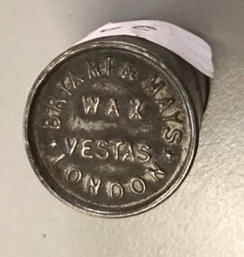 8th/13th Victorian Mounted Rifles Regimental Collection
Functional object - match box
Wax matches also known as 'strike anywhere' were invented in 1826 by William Newton in England. It consisted of a wax stem with embedded cotton threads and a tip of phosphorus. Cases of various styles were introduced to protect against accidental combustion. This simple but robust metal cylindrical box with close fitting cap made it attractive to soldiers in World War One. Bryant & May was a British company created in the mid-19th century specifically to make matches. In 1901 they acquired the rights to the Swan Vesta process.Match cylinder with press on lid.On cap " Bryant & Mays Wax Vesta London"match, bryant & may -
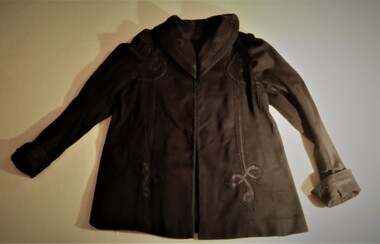 Hymettus Cottage & Garden Ballarat
Clothing - Ladies' jacket
The elaborate fancy cotton braid known as Cornelli work on this jacket is a technique of embroidery or applique of cotton thread and braid that became popular in the nineteenth century. It was used on French doll's clothing where elaborate the Cornelli wear was stitched on for decoration. The examples used in this family also included that on men's railway uniforms and bandsmen's uniforms. This jacket belonged to Eleanor Burke (nee McKew) Mrs Mary Taffe's mother and came to Hymettus at Ballarat when she arrived here to live from Donald with husband Michael in 1945.This jacket displays elaborate fancy cotton stitching and braid known as Cornelli work, a technique of embroidery or applique of cotton thread and braid that became popular in the nineteenth century. This lady's jacket is a good example of a style popular at the end of the nineteenth, early twentieth century. -
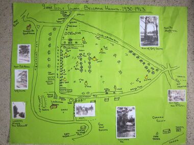 Southern Sherbrooke Historical Society Inc.
Photograph - 9 hole golf course-Belgrave Heights 1930-1943 map
Hand drawn map of Belgrave Heights and its 9 hole golf course, between 1930 and 1943 created by Betty de Coite nee Woods, who holidayed in the area with her family. Map drawn in marker. Photographs attached, including a view of the golf course, Fern Glade Tracks, Lockwood Rd, the dam at Marama Rd corner, The Crescent, the path near the club house, and a wagon near golf course. These photos were taken by members of the Woods family. Map highlights Lockwood House at the corner of Lockwood Rd, the 9 hole golf course, and Sunnyside guesthouse. Club house at Lockwood Rd is later the site of the Convention Centre. Above club house is Fred and Ruby Cook's House. -
 Kew Historical Society Inc
Plan - Subdivision : Cotham and Glenferrie Roads, J R Mathers & McMillan
The Kew Historical Society's map collection includes a substantial number of real estate subdivision plans, mainly of Kew but also of surrounding suburbs in Melbourne. Most of the subdivision plans date from the 1920s and 1930s when the districts old homes and local farmland were being split up to accommodate residential growth in the postwar period. These early plans were assembled by a local firm, Jas R Mather & McMillan, which had an office in Cotham Road. Many of the plans, and sometimes photos, were annotated by the agents.Subdivision plans are historically important documents used as evidence for the growth of suburbs in Australia. They frequently provide information about when the land was sold as well as evidence relating to surveyors and real estate and financial agents. The numerous subdivision plans in the Kew Historical Society's collection represent working documents, ranging from the initial sketches made in planning a subdivision to printed plans on which auctioneers or agents listed the prices for which individual lots were sold. In a number of cases, the reverse of a subdivision plan in the collection includes a photograph of a house that was also for sale by the agent. These photographs provide significant heritage information relating house design and decoration, fencing and household gardens.The photograph may also be aesthetically significant depending on the importance of the photographic atelier.An undated and untitled hand-drawn and coloured subdivision plan detailing the boundaries of a number of irregular allotments bordering Cotham Road, Glenferrie Road and Stirling Avenue (now Stirling Street). The plan predates the actual subdivision that led to the creation of the eight commercial properties occupying 118-132 Cotham Road. The plan may represent an old subdivision that was further subdivided at a later date, or it may be a subdivision that never eventuated. On MMBW Detail Plan 1575 (1903), the area represented by the proposed subdivision was residential rather than commercial. The irregularity of lots is also apparent in the MMBW Plan. The largest of the unnumbered blocks on the hand-drawn subdivision plan may relate to the boundaries of the nineteenth century mansion identified as ‘Kelso’ on the MMBW Plan.subdivision plans - kew, cotham road - kew,, glenferrie road - kew , stirling avenue street - kew -
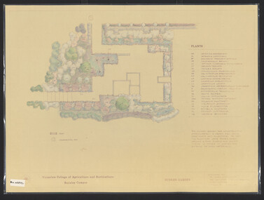 University of Melbourne, Burnley Campus Archives
Plan, James Hitchmough, Sunken Garden, 1981-1989
Most plans were held in Geoff Olives's office.(1) Sunken Garden. 1 tracing paper copy and 1 paper, laminated, coloured. Designed by Dr. James Hitchmough, drawn by Jill Kellow c1989. Plants supplied by Victorian Wholesale Nurseries Pty. Ltd. (2) The Sunken Garden. 1 tracing paper, partly coloured, 1 paper copy. Designed by James Hitchmough, drawn by Jill Kellow 20.12.1988. (3) Burnley Horticultural College Gardens Development Sunken Gardens: Plan Proposal I, March 1981 on tracing paper. (4) Burnley Horticultural College Gardens Development Formal Sunken Garden Proposal 2, March 1981 on tracing paper. (5) Burnley Horticultural College Sunken Garden Scheme II by G. Olive on tracing paper. Plants supplied by Victorian Wholesale Nurseries P.L. sunken garden, james hitchmough, jim kellow, andrew smith -
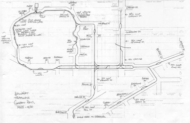 Ballarat Tramway Museum
Document - Photocopy, Dave Macartney, Drawing of ESCo Ballarat Tramways, c1990
Photocopy of a drawing prepared by Dave Macartney in the mid 1980's of the track layout of the Electric Supply Co. of Victoria's Ballarat Tramway system, excluding the single track to Sebastopol. Plan shows the location of the loops, loop type, street names, position of replacement loops installed by the SEC during the reconstruction, depot layout, powerhouse siding and railway in Lydiard St. North. Prepared from inspecting the Plans of Ballarat services drawings in the Ballarat Water Board's Offices. Drawn on the back of old import forms of a light weight paper and has shown through the printing underneath. Titled "Ballarat Tramways Company Days 1905 - 1930" Number of small differences to the map drawn for Keith Kings, "The Ballarat Tramways" book, page 22.trams, tramways, ballarat, esco, track layout, map -
 Bendigo Historical Society Inc.
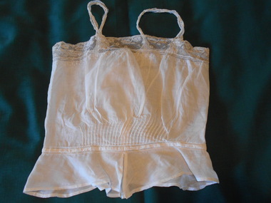
Clothing - MAGGIE BARBER COLLECTION: CAMISOLE, Late 1870-80's
Clothing. Fine white linen fabric. A .8 cm 'tuck' edged at top and bottom with a spoke-stitched border, marks the waistline. Below the waistline is a peplum, split at the centre front with 8 cm deep peaks. These peaks are repeated at the centre back. The peplum tapers to 7 cm deep at side seams. The camisole is trimmed at the top edge with a 4 cm deep band of cotton lace. The top edge of the linen fabric has a double row (off set) of cotton embroidered 'spots' 2 mm in diameter, and three rows of drawn thread work - one cm in width, 3.5 cm wide lace form the shoulder straps. The back opening fastens with six tiny 7cm pearl buttons, and hand-stitched button holes. The lower button fastens with a loop at the waistline 1880-90's. A 'fan' of pintucks, arched from 4 cm long at the ends, to 6 cm long at the centre, fans the midriff at the centre front, above the waistline - 28 tucks in total.costume, female, camisole. -
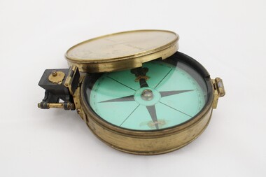 National Communication Museum
Equipment - Prismatic compass, Alfred E Sawtell, before 1872
After years of precursory surveying, debate and proposals the most ambitious civil engineering project of the day, the Overland Telegraph Line, began construction in September 1870. Superintendent of Telegraphs, Sir Charles Todd led the construction through “terra incognita,” guided by the precursory surveys of John McDowall Stuart and technologies such as his prismatic surveying compass. The unknown and hostile landscape claimed the lives of several men and scores of transport animals in the dogged pursuit of telegraphic connection to the rest of the world. Completed in August 1872, the Line connected Australia to the world via telegraph wires running 3,200 kilometres from Port Augusta in South Australia, to Darwin, then connecting via submarine cable to Java and beyond. The “earth [had been] girdled with a magic chain” according to the then Governor of New South Wales, Sir Hercules Robinson. How does it work? For use in surveying, the sight vane and prism are turned up on their hinge and the instrument is held horizontally either in the palm of one's hand or on a tripod. Two small discs of red and green glass attached to the prism can be flipped down over the sight line to reduce glare. The objective is to bring the subject into the sightline created by the prism, aligning with the thread of the sight-vane until the subject is bisected evenly. Once aligned, the division on the card may be read through the prism. This reading provides the magnetic azimuth, used for calculating the bearings of distant landmarks. Circular instrument mounted in a brass case with glass window and brass lid. The compass card face four black compass points printed on mint green paper; on the underside the magnetic needle would be affixed, all held in place by a brass knob at the centre. The arched labels of "Sawtell" and "Adelaide" and the Prince of Wales feathers appear to have been affixed with adhesive which has since yellowed in the areas of application on the compass card. The compass face is printed with numbers, every 10 degrees from 10 - 360, printed in reverse indicating this compass would have once held a mirror at the sighting bracket. On one side of the brass case is a brass hinged sighting-prism, possibly of ebonite. The sighting-prism is mounted in a hinged brass bracket on one edge of the brass case. It has two flip-type filter glasses (red and green) and folds down into a retracted travelling position. A hinged brass bracket on the opposite edge would have held the sighting bracket - carrying the sighting vane and mirror - which is now missing or removed. Under the hinge is a lever, possibly related to the movement of the bracket. Underneath the brass case is an indented circle with screw threads, possibly for attachment to a tripod, and indistinguishable marks scratched into the surface.Etched on to the centre of the lid, "Sawtell ADELAIDE / No 792." Affixed to the paper compass face, possibly from separate pieces of paper, "SAWTELL / ADELAIDE" with the Prince of Wales Feathers above "SAWTELL". Underneath on remains of white tape in red: "159."surveying, compass, charles todd, overland telegraph line, telegraph -
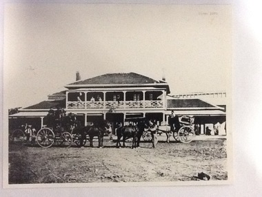 Port of Echuca
Photograph, Approx. 1970's
The Bridge Hotel was built by Henry Hopwood to house visitors to the town crossing the Murray River on his punt , which was situated just below the Bridge Hotel on the Murray River. The accommodation was spacious and grand! In the right back corner of the photograph, the 'lantern' roof of the St George's Hall can be seen. The street is level with the front entrance to the Hotel, which is very different to what it is today.The photograph shows hotel activities and accommodation in the late 19th Century. The Bridge Hotel was a very busy place as can be seen with women on the balcony, a stage coach full of people, laden carts and buggies.The Bridge Hotel Echuca - photo taken looking south towards front of building. Four people can be seen on the balcony and several gathered under the verandah. In the foreground are several horse-drawn carriages. The road in front of the hotel is unmade and very wide, with the roof of St.George's Hall seen over the right (western) wing of the hotel. Verso: Bridge Hotel, 1860s? St. George's Hall in background.bridge hotel, henry hopwood, lantern roof, st.george's hall, 1870s -
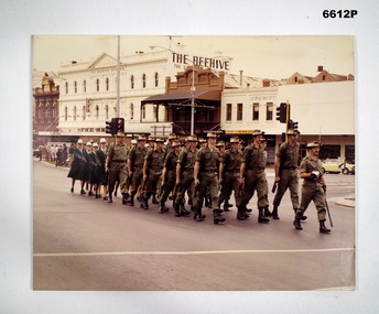 Bendigo Military Museum
Photograph - PHOTOGRAPH, GROUP OF SOLDIERS MARCHING, Australian Army, c 1982 - 2000
Colour photo mounted on cardboard. Squad led by Officer R. Hattam with drawn sword. There are 18 male soldiers dressed in khaki Ceremonial. They are carrying SLR rifles and wearing slouch hats. The female soldiers are wearing the winter ceremonial green uniform with light green hats. They are partially obscured and appears to be approx 12 of them.passchendaele barracks trust, cmf bendigo, 15 tpt sqn -
Glenelg Shire Council Cultural Collection
Negative - Glass Plate Negative - Two people in horse drawn buggy, conifers in background, 1890-1910
Glass plate negative. Two people in horse drawn buggy, conifers in background. Estimated dress to be late 19th, early 20th Century. Includes a Hand written note from Mrs Isobel Burch (nee Taylor) expressing the view that the couple in the buggy are her parents - Mr & Mrs Ern Taylor, enclosed with negative. -
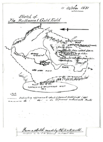 Federation University Historical Collection
Plan, Sketch of Ballaarat Gold-Field, 1851, 11/10/1851
The sketch was made by A.C. MacDonald, F.R.G.S. and presented to James Oddie, who was one of the earliest gold diggers at Ballarat..1) Reproduction of a line sketch plan of the Ballarat goldfield as it was on 11 October 1851 as drawn by A.C. MacDonald, and recopied by C.M. Yelland. The dots indicate appoximate extent of the Ballarat Goldfield in 1851. The dot and dash line indicates approximate area covered with tents. .2) Includes an indication of the locality of the Township of Baallarat West in 1867. Verso of cat. No. 4296.2, and written by Keith Rash - "On 10th October 1851, 1,300 licenses had been issued. 30th October 1851 2246 licenses. Lieut. Gov. LaTobe letter to Earl Grey." james oddie, a c macdonald, gold commissioner, mcleod, alfred clark, kavanagh, willis, highett, yarrowee river, a.c. macdonald, ballarat goldfield, ballaarat goldfield, lamda, c.m. yelland -
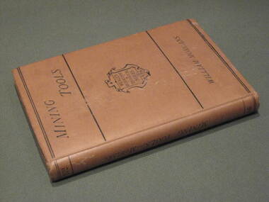 Federation University Historical Collection
Book, Manual of Mining Tools, 1871, 1871
The author, William Morgans, was a lecturer on mining at the Bristol School of Mines. The owner of the book, William Baragwanath, was a former student of the Ballarat School of Mines who held the following positions: Department of Mines (1897-1922); director of the geological survey (1922-24); chief mining surveyor (1924-32); secretary for mines (1932-34); chief mining surveyor (1934-43); consultant to the Department of Mines (1943-50); President, Royal Society of Victoria (1943-44), councillor of the Ballarat School of Mines (1916-50).Hard cover book of 207 pages with buff cloth cover. The books covers materials andf processes used in the manufacture of tools, special uses, qualities and efficiciency. It includes 235 wood engravings of mining tools drawn to scale. Tools include borers, hammers, sledges, picks, shovels, spades, saws, helves and handles.Title page handwritten in ink 'W.B.' [William Baragwanath]mining, tools, ballarat school of mines, geology, bristol school of mines, government geologist, william baragwanath -
 Flagstaff Hill Maritime Museum and Village
Document - Plans, Lighthouse Keeper's Quarters Warrnambool, 1858-1909
The set of seven 1858 plans shows proposed plans for the original Lighthouse Complex that was built on Middle Island in 1858-1859. The whole complex was then transferred to Flagstaff Hill in 1871. The plan, dated 1909, is for proposed additions and repairs to the Quarters at Flagstaff Hill. The plan 'Alterations and Additions' shows alternate plans for changes to the quarters at the Flagstaff Hill location. This plan has no date. The Complex comprised the Lighthouse, the Lighthouse Keepers’ Quarters, the Store (now called the Chart Room) and a Privy, which was not included in these plans. The Keeper’s bluestone Quarters was a cottage divided into two compartments, one for each keeper and his family. The bluestone Store was divided into three; a store, a workshop an oil store (or office). The Privy comprised of a small building also divided into two separate, back-to-back toilets, one for each Keeper and his family. The Flagstaff Hill Keeper's Quarters have had extensions and additions at various times, and these have also been removed at various other times. THE PLANS - *Dec. 1858 (12/58) ‘Lighthouse Keepers Quarters No.2 Warrnambool’ (2375.01)* Public Works Office Melbourne – Front and Back elevations, sections, and floor plan. The drawing shows timber walls. [The floor plan is the closest plan to the current building, however, the walls are timber in this plan.] *Nov. 1858 – No.3 ‘Lighthouse Keepers Quarters Warrnambool’ (2375.02)* Office of Public Works, Melbourne – Back and End elevations and section through. The drawing shows stone walls. One side; Senior Keeper’s bedroom, living room and kitchen with storeroom. Another side; is the Assistant’s bedroom, living room and storeroom. *Nov. 1858 - No.4 ‘Lighthouse Stores Warrnambool’ (2375.03)* Office of Public Works – Front, Side and end elevations, centre section. The drawing shows stone walls. *Nov. 1858 – No.4, ‘Lighthouse Stores No. 2 Warrnambool’ (2375.04)* Office of Public Works – Front, side and end elevations, centre section. The drawing shows timber walls. *Nov. 1858 – ‘Details Lighthouse Keepers Quarters No. 2 Warrnambool’ (2375.05)* Public Works Office Melbourne. The plan shows the foundations, joists and eaves. The drawing shows timber walls. (Nov. 1858 – ‘No.4 ‘Lighthouse No. 2 – Warrnambool’ (2375.06)* Public Works Melbourne (Part of the paper is missing). This plan shows an octagonal tower, internal stairs, a balcony landing, and a weather vane on top. *November 1858 – No. 1, ‘Lighthouse – Warrnambool’ (2375.07)* Office of Public Works Melbourne. This plan shows a round tower, including the stairs, windows on the tower and the weather vane on the top. *4/3/9 [1909] – ‘Additions and Repairs, Lighthouse Quarters, Warrnambool, General Plan’ (2375.8)* Department of Public Works Melbourne’s official stamp is signed by Croft. It shows the floor plans of the Store, Upper Lighthouse and the Quarters. The Store building has three sections; a Store, Work-Shop and Office, with an internal wall between them and separate entries. The Quarters are divided into two dwellings. The Senior Keeper’s side on the left has fireplaces in two of the three bedrooms and there is a pantry and wash house. The Assistant’s side has no fireplaces in the bedrooms and there’s no pantry or washhouse. These plans include proposed changes to the buildings. The Senior Keeper’s Quarters would have a partition on bedroom 2, a bath with plumbing and drainage, a wall moved and a built-in side porch. The Store would also have a built-in porch. The undated plan 'Additions and Alterations' (2375.9) shows alternative arrangements for water tanks, plumbing and such. WARRNAMBOOL'S LADY BAY LIGHTHOUSES- In the 1800s ships sailing from England to Australia began to use Bass Strait as a faster route to Melbourne. Small navigation errors led to many tragic shipwrecks. From 1848 lighthouses were operating along Victoria’s southern coast as a guide for sailors. Coastal towns such as Warrnambool grew and the exchange of trade and passengers were of great benefit. However, the uncertain weather changes, relatively shallow waters and treacherous, hidden rocky reefs were not suitable for a Harbour and in the 1840s and 1850s there were many shipwrecks in the area, with some even stranded in its Lady Bay harbour. A jetty was built in 1850 and a flagstaff to guide seafarers was placed up high on what became known now as Flagstaff Hill. In November 1857 the Victorian Government recommended that Warrnambool Harbour had beacons and two lighthouses to guide vessels into and out of the Harbour safely. The white light of the Middle Island lighthouse was to be used for the first time on September 1, 1859. The red light of the Beach Lighthouse, a wooden obelisk structure, was first operated on March 25, 1860, but in 1868 this light was ‘discontinued’ due to it being too low. Melbourne’s Department of Public Works decided to relocate the Middle Island Lighthouse Complex - Lighthouse, Keeper’s Quarters, Privy, Store Room and even water tanks - to Flagstaff Hill. The lower obelisk was shortened, and a protruding gallery, railing, and external ladder were added, as well as the light from the Beach Lighthouse. A green guiding light was erected on the end of the jetty. The transfer of the Complex began in March 1871. Each shaped stone of the lighthouse was carefully numbered, removed then reassembled on Flagstaff Hill. In 1872 the well was sunk behind the Lighthouse Keeper’s Cottage. The Keepers and families had left Middle Island in April and moved to Flagstaff Hill in October 1871. Vessels entering Lady Bay align the Upper and Lower Lighthouse towers during the day and the lights at night. The Upper Lighthouse is a round tower, the Lower Light is square. The Lighthouses were categorised as harbour lights rather than coastal lights, so they remain under the control of the Victorian Government’s Ports and Harbours section. The lights were originally powered by oil, then acetylene gas, later by electricity, and then converted to solar power in 1988. In 1993 the solar panel was replaced by a battery charger. A decision was made in 1936 to replace the lighthouses’ lights with unattended lights that no longer required Keepers and Assistants. At least 29 Keepers had attended to the lighthouse from its opening in 1859 to when the last official Lightkeepers left In April 1916. The Warrnambool Harbour Board rented out the Quarters from 1916 to 1936. The Board closed down but the rentals continued with other unknown landlords. In the 1970s the Flagstaff Hill Planning Board was set up under the chairmanship of John Lindsay. The Board was to make recommendations to the Warrnambool City Council regarding the use of the buildings and the rest of the Crown Land on the site. The Flagstaff Hill Maritime Village opened in 1975 and began renovating the Cottage in stages, during which time evidence of a 1920s fire was found in the eastern section of the cottage. Additions of a porch on the west and a washroom on the east were made in the 1980s. The western part of the building is now a Shipwreck Museum and the east has returned to a late 19th-century Lighthouse Keeper’s cottage and includes the screen made by Assistant Lighthouse Keeper Thomas Hope during one of his two periods of service there. THE LIGHTHOUSE KEEPERS Lighthouse Keepers were responsible for keeping their Lighthouse’s lights shining at night. They kept a lookout for passing vessels and changes in weather. They were expected to clean, polish and maintain the equipment and buildings. They kept regular and detailed records of who was on watch, and the time the light was lit, trimmed and extinguished. They kept a journal about other events that occurred. They keep regular, accurate Meteorological Logs. It was expected that they were competent in Morse code signalling. They would be called to help in times of disasters and shipwrecks, and to give official statements about these events. Many Lighthouse Keepers also volunteered as members of the lifeboat crew. The Lady Bay lighthouses were officially classified as small, so the Keepers had the official titles of Senior Assistant Lighthouse Keeper and Assistant Lighthouse Keeper. They were employed by the Public Service and paid rent to live in the Lighthouse Quarters. They were compulsorily retired at the age of 60, with most receiving a superannuation payment. Despite their time-consuming duties, there was time to follow hobbies and crafts such as growing vegetables, playing musical instruments, making models of buildings including lighthouses, and crafting furniture pieces. An example of a keeper’s skills is the carved fire screen made by /assistant Keeper Thomas Hope in the early 20th century and displayed in the Lighthouse Keeper’s cottage at Flagstaff Hill. The last occupants of the Middle Island Complex were Senior Keeper Robert Deverell, his Assistant Keeper, Andrew Farncombe, and their families. They all became the first occupants at the Lady Bay Lighthouse Keepers’ Quarters on Merri Street. The Warrnambool Lighthouse Complex plans are the origin of what is now the Lady Bay Lighthouse Complex. They are a record of the people, process and departments involved in bringing the complex into fruition. The plans are significant to the Complex, which is now listed on the Victorian Heritage Register, H1520, for being of historical, scientific (technological) and architectural significance to the State of Victoria. The Complex is significant as an example of early colonial development. The plan are significant for their connection with the important navigational function of the Lighthouses, a function still being performed to this day. The plans are also significant as an example of a product from the Public Works Department in Victoria in the mid-to-late 19th century. The structures built to these plans still stand strong. Plans for the Lighthouse Complex in Warrnambool, including Lighthouses, Keeper's Quarters and Stores. Seven of the plans are on thin fragile paper, one is on thicker, stronger paper. The drawings have been made in pens coloured red and black. They originate from Public Works in Melbourne. Seven were drawn in 1858, one in 1904, the other is not dated.Dec. 1858 - Lighthouse Keepers Quarters No.2 Warrnambool. Public Works Office Melbourne. Nov. 1858 - No.3 ‘Lighthouse Keepers Quarters Warrnambool. Public Works Office Melbourne. Nov. 1858 - No.4 ‘Lighthouse Stores Warrnambool. Office of Public Works. Nov. 1858 - No.4, ‘Lighthouse Stores No. 2 Warrnambool. Office of Public Works. Nov. 1858 - Details Lighthouse Keepers Quarters No. 2 Warrnambool. Public Works Office Melbourne. Nov. 1858 - No.4 ‘Lighthouse No. 2 – Warrnambool. Public Works Melbourne. Nov. 1858 - No. 1, Lighthouse - Warrnambool. Office of Public Works Melbourne. 4/3/9 [1909] - Additions and Repairs, Lighthouse Quarters, Warrnambool, General Plan. Department of Public Works Melbourne. SIGNED "Croft" "15A" on reverse [no date] - Lighthouse Quarters Warrnambool, Additions and Alterations. "9A" on reverseflagstaff hill, warrnambool, lighthouse keeper's cottage, lighthouse residence, lighthouse, plans, public works, melbourne, flagstaff hill maritime museum, maritime museum, shipwreck coast, flagstaff hill maritime village, chart room, quarters, privy, middle island, beach lighthouse, obelisk, lighthouse keeper, assistant keeper, lighthouse complex, lady bay, lady bay complex, keepers, upper lighthouse, lower lighthouse, ports and harbours, cottage, harbour board, flagstaff hill planning board, meteorological record, robert deverell, andrew farncombe, warrnambool port, warrnambool harbour, residence, alterations, repairs, department of works -
Bendigo Historical Society Inc.
Photograph - GOLDEN SQUARE LAUREL STREET P.S. COLLECTION: PHOTOGRAPH ALBUM 1984
Laurel St primary school pupils Grade 5-6 1984 colour photographs mounted in red covered album. Christian names as captions. Mr Rodda captioned as cricket coach amongst sporting people enclosed. Hand printed 'Happy Days at Laurel Street' with hand drawn depictions of children playing games.bendigo, institutions, golden square primary school -
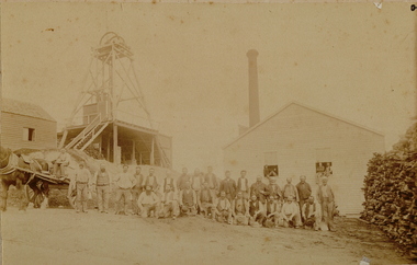 Bendigo Historical Society Inc.
Photograph - MINE
Sepia photo on fawn board. 27 workmen in front of mine buildings, horse and dray on left, poppet head to left, mine building and chimney stack. Large pile of cut wood on right. 3 men sitting in open windows of building behind group. Blue pencil line drawn on the board, framing the photo.place, mining site, mine? -
 Bendigo Historical Society Inc.
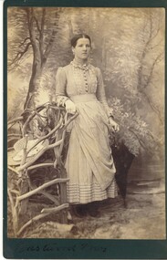
Photograph - HARRIS COLLECTION: FEMALE PHOTO, ninteenth century
Full length studio photograph of young woman leaning against rustic tree branch chair. Straw hat in chair. Drawn back hair parted in middle. Long sleeved Gingham dress, closed neck with brooch. Hand written on front, 'Eastwood Bros'. Hand written on reverse, Eastwood Bros Photographers, Bairnsdale.Eastwood Bros Bairnsdalephotograph, person, female -
Bendigo Historical Society Inc.
Map - CAMPASPE : COUNTY OF BENDIGO, 1964
Map. Campaspe, County of Bendigo, County of Rodney, Runnymede, Nolan, Muskerry, Toolleen, Colbinabbin, Campaspe River, Goornong, Mount Pleasant Creek. By authority A.C. Brooks, Government Printer, Melbourne. Drawn and reproduced at the Department of Lands and Survey, Melbourne. 1964. Price 10/- per sheet. (number 112 in map cupboard 1)A.C. Brooks, Government Printer, Melbourne.map, bendigo, campaspe -
 Whitehorse Historical Society Inc.
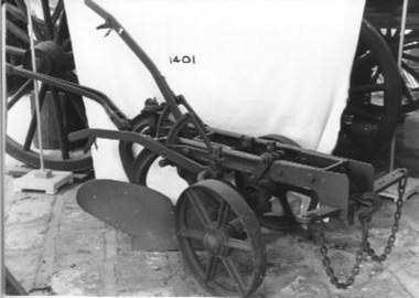
Machine - Plough
Horse drawn one way plough with one share - mould board; two discs, one fluted. Two off set adjustable wheels. Hand steered. adjustable. Suited for dry soil and hillside. Possibly made by Thomas H Corbett of Perseverance Ironworks in Shrewsbury Shropshire who developed a similar plough in 1870s.'V13R and A8178' on the main frame. 'DH53' on rotary blade.|'V5' on handle attachment to frame.rural industry, orcharding -
 Ballarat Tramway Museum
Negative, Wal Jack, late 1930's
Yields information about Ballarat 's tram operations and the Victoria St terminus.Negative and Digital image of the Wal Jack Ballarat Negative file of No. 20 at the Victoria St terminus. A crewman is about to step from the car. In the distance is a horse drawn cart delivering - possibly bread or milk. The tram has the destination of Gardens via St west. The trolley pole is yet to be turned. Shows the overhead arrangements. trams, tramways, victoria st, horse drawn vehicle, tram 20