Showing 3589 items
matching white city
-
 City of Kingston
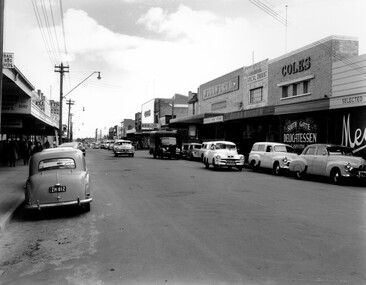
Photograph - Black and white, c. 1956
Black and white photograph depicting Centre Road Bentleigh, looking west. On the right hand side of the road there are two Coles stores. The one in the background is the newly opened store while the one in the foreground has been repurposed and is now a delicatessen. There are numerous cars parked on both sides of the road, including one that appears to be "double parked" on the right hand side of the road.Black and white photograph depicting Centre Road Bentleigh, looking west. On the right hand side of the road there are two Coles stores. The one in the background is the newly opened store while the one in the foreground has been repurposed and is now a delicatessen. There are numerous cars parked on both sides of the road, including one that appears to be "double parked" on the right hand side of the road.Handwritten in blue ink on a white sticker adhered to the reverse of the photograph: COLES BENTLEIGH c. 1956 / Centre Road looking west / The Old Coles store is in the foreground / and the new Coles is in the background.bentleigh, suburbs, shopping strip, cars -
 City of Kingston
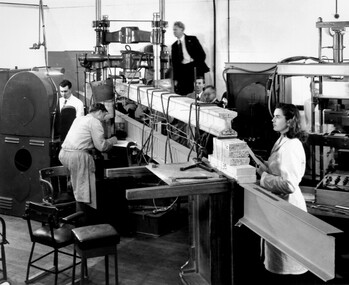
Photograph - Black and white, c. 1950
CSIRO, the Commonwealth Scientific and Industrial Research Organisation, moved into a former RAAF factory in Highett in the post-war years. CSIRO closed down the Highett facility and sold it in 2011.Black and white photograph of workers at CSIRO (Commonwealth Scientific and Industrial Research Organisation) complex in Highett. In this image, building materials are being tested. In the foreground is physicist Valerie Goullet, standing top centre is Dr Keith Martin both CSIRO Division of Building Research.Small white sticker adhered to reverse of image with printed black text: 206 Handwritten in red ink on reverse of image: 53%science, highett, workers, industry -
 City of Kingston
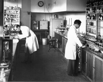
Photograph - Black and white, c. 1950
CSIRO, the Commonwealth Scientific and Industrial Research Organisation, moved into a former RAAF factory in Highett in the post-war years. CSIRO closed down the Highett facility and sold it in 2011.Black and white photograph of workers at the CSIRO (Commonwealth Science and Industrial Research Organisation) facility in Highett.Small white circular sticker with black printed text: 205 Handwritten in red ink: 55%science, highett, workers, industry -
 City of Kingston
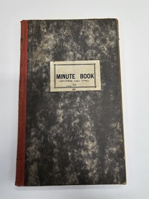
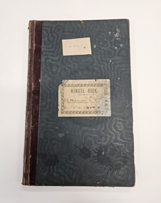
Book - Minute book, Minute book of the Cheltenham Junior Tennis Club, 1923
This minute shows committee members and participants in the Cheltenham Junior Tennis Club, as well as their activities over the years 1923 to 1948. Hardcover book with marbled appearance and white paper label on the front. Handwritten in blue ink on paper label: CHELTENHAM JUNIOR TENNIS / CLUB / 1945cheltenham, sport, tennis, committee -
 City of Kingston
Book - Minute book, Minute book, Cheltenham Junior Tennis Club, 1897
This minute shows committee members and participants in the Cheltenham Junior Tennis Club, as well as their activities over the years 1897 to 1923Harcovered green book with burgundy spine and two white labels adhered to the front of the book. Note the labels do not agree on content.Typed in black ink on first white label adhered to front: C. J. T. C. Handwritten in black/blue ink on second label: Cheltenham Lawn [indecipherable] / March 31st 1987 to 29.6.23cheltenham, sport, tennis, committee -
 City of Kingston
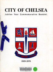
Booklet - Commemorative book, City of Chelsea, City of Chelsea Jubilee Commemorative Booklet, 1970
In 1920 the City of Chelsea was formally proclaimed to be a city, rather than a township. This booklet, produced in 1970 was to commemorate it being 50 years since Chelsea was proclaimed a city.Five (5) page booklet with white cardboard covering with black text at top and bottom and a blue and red coat of arms for the City of Chelsea in the centre. The book was, at one time, registered with the Kingston Library Service and has a barcode and green sticky dot adhered to the front. There are two holes punched into the left hand side of the booklet with a royal blue ribbon threaded through and connected with a bow.chelsea, proclamation, city -
 City of Kingston
Photograph - Black and white, c. 1970
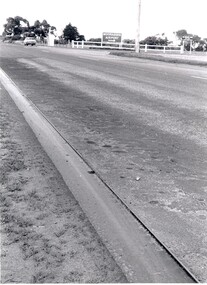
This photograph depicts the steel tramway (or tram plate) along Centre Dandenong Road, Cheltenham near the Moorabbin Airport entrance in the 1970's. These tramways played an important role in transportation along Moorabbin's major roads. Heavily laden carts could travel smoothly and safely along the steel plates when the road surfaces were often rutted and hazardous. This surviving section was later moved for road improvements. The area now known as the City of Kingston was a market garden region and the round trip to market could take as long as eight hours on poorly maintained roads. The installation of the steel tramway transformed the arduous journey faced by market gardeners in transporting their produce to market. As there was only a single tramway, the carts often travelled in convoy, enabling drivers to leave piloting to the first cart and having a rest. The rails did not speed the journey to the city, but it smoothed progress immeasurably. Black and white photograph of steel tram plates on Centre Dandenong Road, Cheltenham. The road is sealed. At the top of the image there are trees behind a parked car which is adjacent to a white shelter. There is a large sign stating MOORABBIN AIRPORT above an arrow pointing to the right in the top centre of the image. Handwritten in pencil: A 28 / [indecipherable] 3 / [indecipherable] Handwritten in red ink: A28 / 70%market gardening, infrastructure, transport, steel tramway, industry, moorabbin -
 City of Kingston
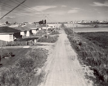
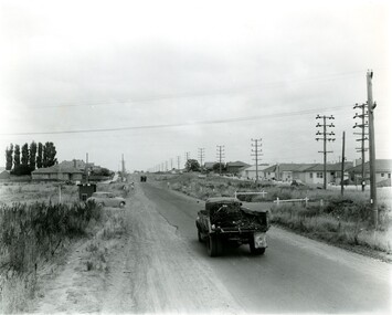
Photograph - Black and white, c. 1960
This image depicts a scene of East Bentleigh in 1960, viewed along Thomasina Street as it crosses Gladwyn Street towards East Boundary Road in the distance. The gardens and new homes are well-tended, but the street surfacing is unsealed.Developing urban area now located within the City of Glen Eira, formally City of Moorabbin. This image illustrates the mid century urban sprawl of new suburbs and the subdivision of market gardens within the municipality and the changing demographic of the district as new houses are constructed and infrastructure established. Black and white photograph of unsealed road in new development in the area of Moorabbin, new houses appear on the lefthand side with paddocks on right side of image with installation of electric poles. Sealed road in the distance. Thomasina Street, as it crosses Gladwyn Street, East Bentleigh towards East Boundary Road. Handwritten in blue ink: 60 - 373 D Handwritten in red ink: 80% Handwritten in black ink: Ch. 6bentleigh, east bentleigh, market garden, housing, suburbs, infrastructure, moorabbin -
 City of Kingston
Photograph - Black and white, c. 1956
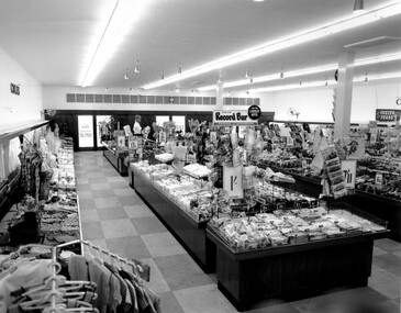
This photograph depicts the interior of the Coles Variety Store within Bentleigh's Centre Road shopping precinct in 1956. Signage represents the pre decimal currency era. The Record Bar advertises the availability of standard and microgroove vinyl records.In this era, the Centre Road Bentleigh shopping strip provided consumers with access to many of the major retail outlets and provided for a wide range of shopping needs. By the 1960s, Chadstone Shopping Centres (opened 1960) and Southland (opened 1968) had been established which created changes to the way in which people shopped.Black and white photograph of interior of Coles Store in Centre Road, Bentleigh displaying prominent signage predating decimal currency. Other signage includes the Coles Record Bar indicating the sale of standard and microgroove vinyl records.Handwritten in blue ink: Coles Bentleigh Sep 1956 B Black printed text on white round adhesive sticker: 202 Handwritten in red ink: 80%shopping strip, strip shopping, bentleigh, city of moorabbin, coles stores -
 City of Kingston
Photograph - Black and white
... train stations and streetscapes in what is now the City ...This photograph depicts the road diversion on Nepean Highway that was implemented to allow construction of the railway line underneath the Nepean Highway at Moorabbin. An "Allourie" Cheese, Honey Canned Ham van is prominent on the left of the image, the railway gates are central and the old Moorabbin Station is visble. Beyond the dates, pedestrians are visible crossing the Nepean Highway. This image is part of a larger collection of images from the Public Transport Corporation displaying train stations and streetscapes in what is now the City of Kingston.In 1958 excavations began for the removal of the level crossing gates at the southern end of the Moorabbin shopping centre on Nepean Highway. The station was also lowered below ground. A diversion route was created to enable the flow of traffic in both directions along the highway.Black and white photograph of road diversion on Nepean Highway, Moorabbin to allow the construction of the railway line below the Nepean Highway at Moorabbin and also to trench the station. This image is part of a larger collection of images from the Public Transport Corporation displaying train stations and streetscapes in what is now the City of Kingston.White adhesive dot sticker: Printed black 199 Handwritten in red ink: 80% Handwritten in black ink on yellow Post-It Note: [indecipherable] 199 - Diversion for Crossing Stamped in blue ink: COPYRIGHT Public Transport Corporation, For reordering photographs, Please quote negative No m 5687, Enquiries C/- PTC Photographic Unit, Telephone switchboard 619 1111railway crossing, railway station, city of moorabbin -
 City of Kingston
Photograph - Black and white, c. 1950
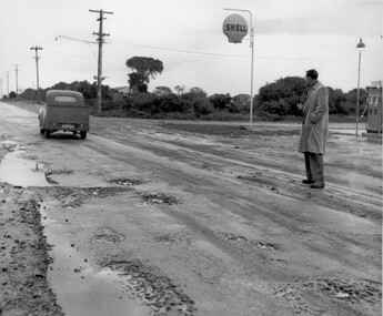
This image depicts the unsealed roads with potholes prevalent in the quickly developing suburbs of Black Rock and Beaumaris. In the post war era, as the suburbs of Beaumaris and Black Rock grew, the infrastructure for roads was falling behind. The unsealed roads were dusty in summer and muddy with potholes in winter. Drainage was poor and roads difficult to navigate.Black and white photograph of a man standing outside the Shell service station in Balcombe Road, possibly at Beaumaris. He is watching a utility vehicle with registration GFM033 as it drives on the unsealed road through mud and potholes.Handwritten in blue ink: 2195 Handwritten in red ink: 80%roads, infrastructure, beaumaris, black rock, balcombe road -
 City of Kingston
Photograph - Black and white, c. 1956
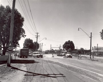
Strip shopping and ample parking were features of suburbs in the middle of the twentieth centuries. Cars were still considered a luxury, although that would soon change, and local, independent shops serviced local areas.During the post-war years, the municipality of Moorabbin experienced a population boom. The 'newcomers' were predominantly returnees from the war who were marrying and establishing families; those from the old inner-suburban areas who were moving away from rented premises to establish their own homes on cheap land. The 1950s were a time of immense growth for the area now known as City of Kingston.Black and white photograph of the intersection of Centre and East Boundary roads, Bentleigh East. Several cars are visible both in the foreground and background, and the intersection includes a roundabout. The street is lined with poles to carry electricity cables, and the roundabout is dotted with four poles for electric street lights.Handwritten in blue ink: 56 - 230 Handwritten in red ink: 82% Handwritten in black ink: Ch. 6shopping strip, cars, suburbs -
 City of Kingston
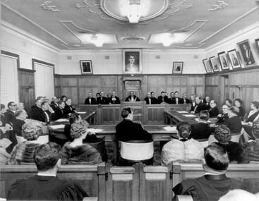
Photograph - Black and white, 1962
Local government for Moorabbin began in 1862 when the area was separated from Brighton with the creation of the Moorabbin Roads Board. This meeting commemorated the centenary of local government in 1962.1862 saw the beginnings of local government in the Moorabbin district when the area was separated from Brighton with the creation of the Moorabbin Roads Board. Moorabbin was declared a shire in 1871 and a city in 1934. While tinkering with boundaries occurred over time, the first major severance from Moorabbin was when the Borough of Sandringham was created in 1917. Three years later, after persistent agitation, on May 27, 1920 Mordialloc, Parkdale and Mentone became part of the new Borough of Mordialloc. With this change the Shire of Moorabbin no longer had authority for land with a frontage to Port Phillip Bay. In 1994 councils across Victoria were amalgamated and the City of Moorabbin was divided between the cities of Kingston and Glen Eira. The City of Kingston is made up the former cities of Chelsea, Mordialloc, Moorabbin, Oakleigh and Springvale.Black and white image of inside of Moorabbin Council Chambers, with a meeting (possibly staged) in progress. Council members are seated behind a bench which connects to a horseshoe shaped table. All in attendance are in formal attire. Men are wearing black tie and the women in the audience (with backs to camera) are wearing fur coats or stoles.Black printed text of white round sticker adhered to reverse: 191 Handwritten in red ink: 80%moorabbin, council, chambers, council meeting, centenary -
 City of Kingston
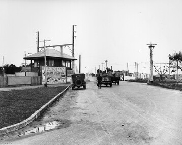
Photograph - Black and white, c. 1930
This image is part of a larger collection of images from the Public Transport Corporation displaying train stations and streetscapes in what is now the City of Kingston.The Nepean Highway is a major highway running through the City of Kingston. This image is one of many that depicts its importance to the local community as it undergoes many changes over time.Black and white photograph depicting the level crossing at Moorabbin. While the gates at the level crossing are open, two cars are making their way across the crossing, while a third car is parked on the side of the road, in front of a large billboard/hoarding for ham and bacon products. There is a man standing on the road as if watching the cars go through the crossing. The road appears to be unsealed. Black printed text on a round white sticker adhered to the reverse: 148 Handwritten in red ink: 60% Blue ink stamped on reverse: COPYRIGHT / Public Transport Corporation / For re-ordering photographs / Please quote negative No ADU907 / Enquiries C/- PTC Photographic Unit / Telephone switchboard 619 111moorabbin, trains, railway crossing, level crossing, cars, roads, nepean highway -
 City of Kingston
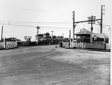
Photograph - Black and white, c. 1930
This image is part of a larger collection of images from the Public Transport Corporation displaying train stations and streetscapes in what is now the City of Kingston.The Nepean Highway is a major highway running through the City of Kingston. This image is one of many that depicts its importance to the local community as it undergoes many changes over time.Black and white photograph depicting railway crossing at Nepean Highway Moorabbin. The level crossing gates are open and a man is walking through with his dog. To the right of the crossing is a billboard/hoarding promoting what appears to be a brand of radio/wireless.White round sticker with indecipherable black printed text which has been scribbled over with black pen. White round sticker with black printed text: 175 Handwritten in red ink: 50% Blue ink stamped on reverse: COPYRIGHT / Public Transport Corporation / For re-ordering photographs / Please quote negative No ADV 903 / Enquiries C/- PTC Photographic Unit / Telephone switchboard 619 111moorabbin, trains, railway crossing, level crossing, nepean highway -
 City of Kingston
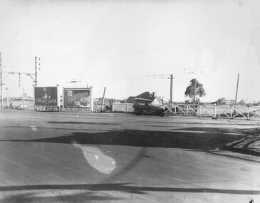
Photograph - Black and white, c. 1930
This image is part of a larger collection of images from the Public Transport Corporation displaying train stations and streetscapes in what is now the City of Kingston.The Nepean Highway is a major highway running through the City of Kingston. This image is one of many that depicts its importance to the local community as it undergoes many changes over time.Black and white photograph of the level crossing at Neapean Highway Moorabbin. Photograph is a slightly side view, with a blurred image of a car approaching the level crossing. The gates are closed. To the left of the image is a pair of billboards. The billboard on the left is promoting Creamoata, a New Zealand brand of oats, and the billboard on the right is promoting Kraft cheese.White round sticker on reverse with black printed text: 147 Handwritten in red ink on reverse: 100% Blue ink stamped on reverse: COPYRIGHT / Public Transport Corporation / For re-ordering photographs / Please quote negative No ADV 1030 / Enquiries C/- PTC Photographic Unit / Telephone switchboard 619 111moorabbin, level crossing, railway crossing, cars, advertising, nepean highway -
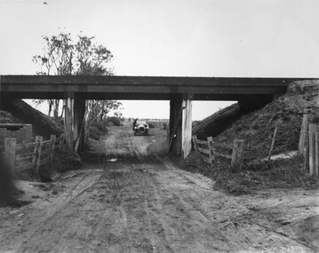 City of Kingston
Photograph - Black and white, c. 1920
This image is part of a larger collection of images from the Public Transport Corporation displaying train stations and streetscapes in what is now the City of Kingston.While the focus of this image is the train line running overhead, the unsealed nature of the road speaks to the progression of suburban development during the 1920s.Black and white image of an unsealed underpass at Patterson Road, looking west. A car has stopped on the road in the distance and man is standing on the duckboard leaning into the car.Round white sticker on reverse with black printed text: 177 Handwritten in red ink: 60% Blue ink stamped on reverse: COPYRIGHT / Public Transport Corporation / For re-ordering photographs / Please quote negative No ADV 300 / Enquiries C/- PTC Photographic Unit / Telephone switchboard 619 111patterson road, railway, trains, cars, unsealed roads -
 City of Kingston
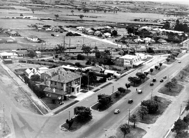
Photograph - Black and white, c. 1930
During the 1930s Moorabbin was an area with open grasslands, still often used for market gardening. The development of the city (and, later, suburb) can be seen emerging from the railway station.The Nepean Highway is a major highway running through the City of Kingston. This image is one of many that depicts its importance to the local community as it undergoes many changes over time.Black and white photograph of aerial view of intersection of Nepean Highway and South Road. Moorabbin Council Chambers are situated on the corner with the library, old shire building, Moorabbin railway station, St David's Anglican Church market gardens and open paddocks in the background.White round sticker on reverse with black printed text: 143 Handwritten in red ink on reverse: 156% / k000786moorabbin, council, railway station, railway, suburbs, paddocks, nepean highway -
 City of Kingston
Photograph - Black and white, c. 1950
The image shows a line of traffic travelling along South Road in response to traffic light signlas while an increasing number of cars are banking up along Nepean Highway, also in response to traffic light signals.This image provides a strong contrast to images from earlier eras of the same intersection. The amount of traffic has increased enormously as well as commercial development.Black and white photograph with an aerial view of the intersection of Nepean Highway and South Road, taken from above the Moorabbin Council Chambers.Handwritten in black ink Pic [indecipherable] / 1000 Handwritten in red ink: 150%moorabbin, traffic lights, cars, nepean highway -
 City of Kingston
Photograph - Colour, 2000
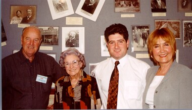
Narratives of Kingston was an oral history project where the personal memories of residents were collected and compiled into a reference book. The image suggests there was also an exhibition of personal photographs as the people depicted are standing in front of photo boards.Colour photograph taken at the launch of the Narratives of Kingston project. Depicted in the image (L to R) are Ron Jacobs, President Chelsea Historical Society, Sylvia Roberts, granddaughter of Roderick Mills/Saltbush Bill, Mayor Arthur Athanasopoulos, and Piri White, member of the Narratives team. People pictured are standing in front of a photo board.Handwritten in red ink on reverse: K000740.tif Launch of Narratives of Kingston / Ron Jacobs - Presidetn Chelsea Hist Soc / Sylvia Roberts - granddaughter of / Roderick Mills/Saltbush Bill / Mayor Arthur - Mayor of Kingston / Piri White - member of Narratives Teamoral history, kingston -
 City of Kingston
Photograph - Colour, 2000
Narratives of Kingston was an oral history project where the personal memories of residents were collected and compiled into a reference book. The image suggests there was also an exhibition of personal photographs as the people depicted are standing in front of photo boards.Colour photograph taken at the launch of the Narratives of Kingston project. Depicted in the image (L to R) are Ron Jacobs, President Chelsea Historical Society, Sylvia Roberts, granddaughter of Roderick Mills/Saltbush Bill, Mayor Arthur Athanasopoulos, and Piri White, member of the Narratives team.oral history, kingston, mayor, historical societies -
City of Kingston
Photograph - Colour, 2000
Narratives of Kingston was an oral history project where the personal memories of residents were collected and compiled into a reference book. The image suggests there was also an exhibition of personal photographs as the people depicted are standing in front of photo boards.Colour photograph taken at the launch of the Narratives of Kingston project. Depicted in the image (L to R) are Ron Jacobs, President Chelsea Historical Society, Sylvia Roberts, granddaughter of Roderick Mills/Saltbush Bill, Mayor Arthur Athanasopoulos, and Piri White, member of the Narratives team.oral history, kingston, mayor -
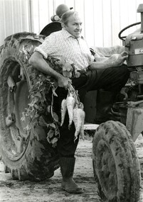 City of Kingston
Photograph - Black and white, Moorabbin News, 1963
Francis (Frank) Wilbur Le Page was mayor of Moorabbin between 1980 - 1981, and again in 1984 - 1985. He was a lifelong resident of the region and also a third generation market gardener.In approximately 1854, Nicholas Le Page moved his family from Prahran to Cheltenham. Two years earlier, they had arrived in Melbourne from Guernsey Island. Nicholas Le Page was a tailor and his wife was a dressmaker. They decided to move into market gardening instead. Their son, Everest, married Lynda and Francis Wilbur Le Page was born in 1919. He attended Cheltenham State School where he completed his Merit Certificate in grade eight before studying bookkeeping, shorthand and typing at Bradshaw and Everett Business College in South Melbourne. Both Frank’s grandfather and father were active in local government. Francis Thomas Le Page was a councillor for 25 years and served a term as shire president in 1902. Everest, his son, was a councillor for the City of Moorabbin for 28 years and was mayor on two occasions. Frank also served two terms as mayor, first in 1980 and again in 1984. Frank died on 14 July 2008.Black and white photograph of Frank Le Page stepping down from a tractor, with a bunch of parsnips in his right hand.Pink coloured paper adhered to reverse with black printed text and handwritten text in blue ink: STANDARD NEWS / Paper MOOR / Catchline Garden / Percentage 88% / Date 17-10-84 / Page 23le page, market gardens, tractor, moorabbin -
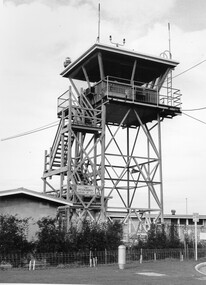 City of Kingston
Photograph - Black and white, c. 1970
Moorabbin Airport was acquired in 1946 by a group of aviators and the Civil Aviation Department, Moorabbin Airport opened as a fully-functioning aerodrome in December 1949, chosen for its ideal location in the Market Gardens for an aviation base to be situated southeast of Melbourne. Black and white photograph of the control tower at Moorabbin Airport. At the base of the tower is a single storey brick building with a wire fence at the running across the front.Handwritten in black ink on reverse: 701 Handwritten in red ink on reverse: 100%moorabbin, airport, aviation -
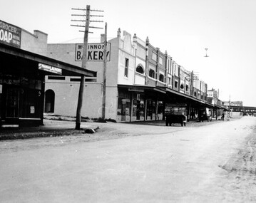 City of Kingston
Photograph - Black and white, c. 1930
Black and white photograph of McKinnon Road, McKinnon. The shopping strip can be seen on the left of the image, along with a couple of trucks parked along the roadway. There a train visible in the distance, crossing at the level crossing while the gates are closed.Typed in black on white strip of paper stuck to reverse: McKinnon Road, McKinnon / circa late twenties/early thirties / $50 reproduction fee applies Blue ink stamped on reverse: COPYRIGHT / Public Transport Corporation / For re-ordering photographs / Please quote negative No ADV 491 / Enquiries C/- PTC Photographic Unit / Telephone switchboard 619 111mckinnon, suburbs, shopping strip, trains, level crossing -
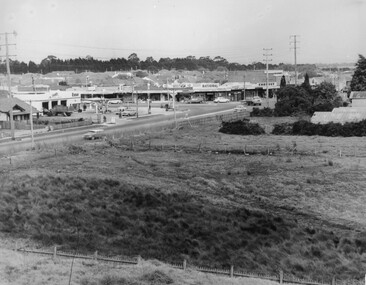 City of Kingston
Photograph - Black and white, c. 1963
This image depicts the intersection of increasing urbanisation and the rural landscape that once made up the area now known as City of Kingston.Black and white photograph of the intersection of Warrigal Road and Centre Road, South Oakleigh, viewed from the reservoir. In the foreground are paddocks and in the background is a shopping strip, including a petrol station.Handwritten in blue ink on reverse: 2196 Handwritten in red ink on reverse: 100%oakleigh, roads, shopping strip, paddocks -
 City of Kingston
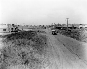
Photograph - Black and white, c. 1957
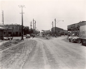
This image shows the urbanisation of a formerly rural area of Moorabbin.Black and white photograph looking west along South Road. There is a truck in the foreground, travelling along the sealed South Road. A car is waiting to exit from Rowan Road. People are walking along the left hand side of the road, and a young person a bike is riding along the right side. They are all going in the same direction as the traffic. The left hand side of the image shows paddocks in the foreground, which houses further back. The right hand side of the image shows suburban houses with electricity poles running the length of the road. Handwritten in blue ink on reverse: 57-523A Handwritten in red ink on reverse: 85% Handwritten in black ink or grey lead: Ch. 6moorabbin, cars, roads, housing -
 City of Kingston
Photograph - Black and white, 1957
This image shows the increasing urbanisation of the formerly rural area of Moorabbin.Black and white photograph of the intersection of South Road and Chesterville Road, Moorabbin. A service station is visible on the left hand side, a truck is travelling along the road and shops are under construction on the right hand side.Handwritten in blue ink on reverse: 57-523B Handwritten in red ink on reverse: 100%moorabbin, shopping strip, paddocks, roads, cars -
 City of Kingston
Photograph - Black and white, c. 1957
... travelling towards the city. Photograph Black and white ...This image depicts the increasing urbanisation of Moorabbin. While there are several cars in line waiting for the train to go through the crossing and the gates to open, in the distance there is a lot of activity on the road, with many cars.Black and white photograph depicting the railway crossing at South Road, Moorabbin. There is a 'Red Rattler' passenger train going through the level crossing travelling towards the city.Handwritten in blue ink on reverse: 57-4078 Handwritten in red ink on reverse: 82% Handwritten in black ink on reverse: Ch. 6moorabbin, trains, cars, urbanisation, suburbs -
 City of Kingston
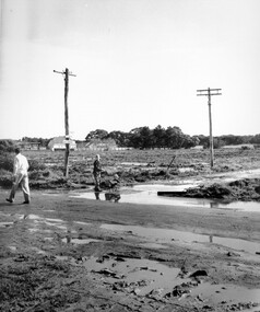
Photograph - Black and white, c. 1950
Black and white photograph depicting the intersection of Balcombe Road and Haywood Street in Beaumaris. The road is unsealed and recent rain has left it boggy and slushy. A man in very light coloured clothes is walking along the road with a newspaper in his left hand. A young boy is pushing a trolley of some kind with two wheels in which another younger child is sitting.Handwritten in red ink on reverse: 92% Handwritten in blue ink on reverse: 2196beaumaris, roads, infrastructure, puddles, children