Showing 6700 items
matching river
-
 Bendigo Historical Society Inc.
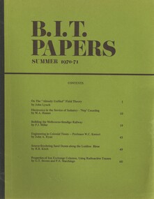
Book - BIT PAPERS, 1971
B.I.T. Papers Summer 1970-71, articles by various contributors, contents include, Building the Melbourne-Bendigo Railway, Engineering in Colonial Times, Source-Bordering Sand Dunes along the Loddon River & others, 66 pages with black and white photographs and maps..history, australian -
 Bendigo Historical Society Inc.
Map - CAMPBELL COLLECTION: BENDIGO AND DISTRICT MAPS, 1929
Map. Campaspe, Parish of Kimbolton. Total area 4117 acres. Campaspe River, Kimbolton. Scale 20 chains to 1 inch. Prepared in W.P.B. form Parish and Assessment Plans. G.W.L. 9-4-29. (number 351 in map cupboard 1)map, bendigo, allotments -
Bendigo Historical Society Inc.
Map - DERBY : COUNTY OF BENDIGO, 1959
Map. Derby, County of Bendigo, Bridgewater, Inglewood, Tarnagulla, Woodstock, Leichardt, Loddon River. By authority A.C. Brooks, Government Printer, Melbourne. Drawn and reproduced at the Department of Lands and Survey, Melbourne. 1959. Price 2/-. (number 54 in map cupboard 1)A.C. Brooks, Government Printer, Melbourne.map, bendigo, derby -
 Coal Creek Community Park & Museum
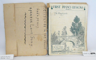
Music Book, First Piano Lessons, Book II, The Countryside
Music book "First Piano Lessons, Book II, The Countryside", Composed by Walter Carroll, covered in brown discoloured paper, original cover has a white background with charming illustration of children walking over stone bridge and fishing in the river, printed in blue.. -
 Clunes Museum
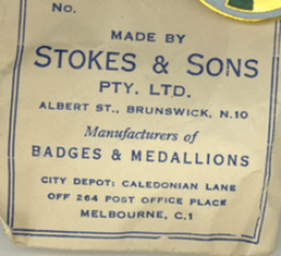
Memorabilia - NUMISMATICS, Stokes & Sons
.1 White metal medal with a tricolour ribbon of red, white and blue. Attached to a ring connected to the medal. One side depicts the scene of landing at Portland in 1834 and the other side depicts a pioneer on the south bank of the Yarra river looking across Melbourne. On Reverse: Centenary of Victoria 1934 and Portland 1834 On Obverse: Centenary of Melbourne 1935 (AD)centenary of victoria 1934, centenary of melbourne 1935 -
Clunes Museum
Document - CENTRAL HIGHLAND REGION WATER
.1 SEWERAGE AND SANITATION - STATISTICAL SUMMERY 30 JUNE 1948 .2 TOWNS WATER SUPPLY. SUPPLIED BY THE STATE RIVERS & WATER SUPPLY COMMISSION - PORTION OF COLIBAN SYSTEM .3 TOWNS WATER SUPPLY DISTRICTS AND WATERWORKS TRUSTS 30 JUNE 1948central highland region, central highland water, state river & water supply commission -
 Anglesea and District Historical Society
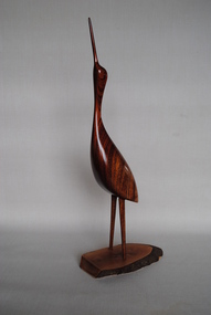
Carved Wooden Bird, Estimated 1990s
Wooden carving of a wading bird made from Australian cedar grown and collected in the Richmond River area of New South Wales. Base made from Bul-oak grown and collected in the Ballan area Vicoria. Makers card, attached, shows No. 974.australian cedar, bul-oak -
 Yarrawonga and Mulwala Pioneer Museum
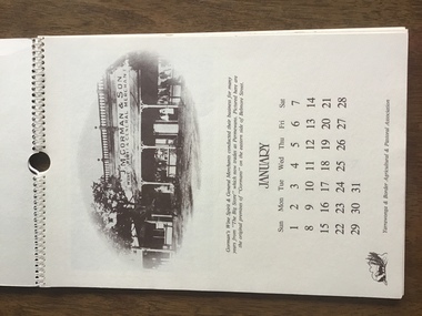
Calendar 1984, Yarrawonga over the Years, 1983
“Spiral bound A4 size 12 pages and front and back cover. Cream embossed heavy paper with sepia print. Contains one page for each month. Depicts early scenes of Yarrawonga Streets, river, hotels, stores, Showgrounds - all with descriptions See photos -
 Ballarat Heritage Services
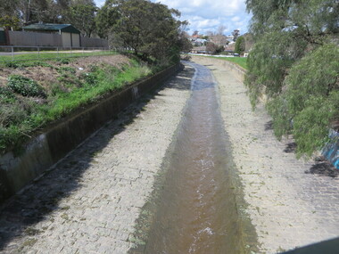
Photograph - Photograph - Colour, Clare Gervasoni, Yarrowee Creek after days of heavy rain, 2016, 17/09/2016
A number of photographs of the Yarrowee River after days of heavy rain. Two and three day previously the water reached the edges of the channel and was flowing very fast. The photographs were taken from and around the Hill Street Bridge near the Sunnyside Woollen Mills.yarrowee creek, yarrowee river, bridge, chanel, hill street, ballarat east -
 Bendigo Historical Society Inc.
Slide - DIGGERS & MINING. DIGGERS AND MINERS, c1800s
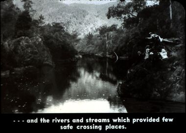
Diggers & Mining. Diggers and miners. Walhalla - Gold Town. - - - and rivers and streams which provided few safe crossing places. Three women and one man on the right bank which is very steep. Markings: 17 995 WAL. Used as a teaching aid.hanimounteducation, tertiary, goldfields -
 Bendigo Historical Society Inc.
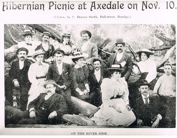
Photograph - PETER ELLIS COLLECTION: HIBERNIAN PICNIC AT AXEDALE
Black and white photograph. 'Hibernian Picnic at Axedale on Nov. 10'. (photos. By P Dermer Smith, Bull-street, Bendigo.) On the River Side. Men and women sitting in and on fallen tree branches. Ladies in hats and long dresses. Men wearing suits and hats.P Dermer Smith, Bull-street, Bendigophoto, group, mixed group -
 Wodonga & District Historical Society Inc
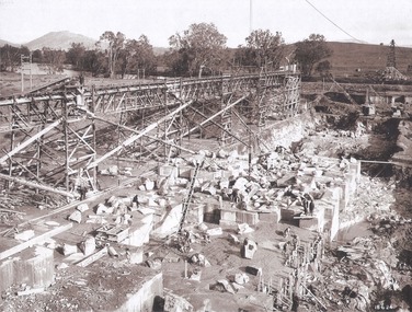
Album - Hume Reservoir Australia Album - Foundation work and dam construction, June 1924
This set of photos is from a leather bound album bearing the inscription "HUME RESERVOIR AUSTRALIA" plus 'The Rt. Hon. L. C. M. S. Amery, P. C., M .P.' all inscribed in gold. It was presented to The Rt. Hon. L. C. M. S. Amery, P. C., M. P, Secretary of State for Dominion Affairs on the occasion of his visit to the Hume Reservoir on 2nd November 1927. This album is of local and national significance as it documents the planning and development of the Hume Reservoir up to 1927. It was the largest water reservoir in the British Empire. The album records the pioneering engineering work that went into its construction.DEPARTMENT OF PUBLIC WORKS, N.S.W. RIVER MURRAY WATERS SCHEME. HUME RESERVOIR. 13. Foundation work and dam construction proceeding inside levee bank which may be seen at the right hand end of the work, New South Wales, June 1924.hume reservoir australia, river murray waters scheme, hume reservoir construction -
 Wodonga & District Historical Society Inc
Album - Hume Reservoir Australia Album - Gravity incline for transport of rocks
This set of photos is from a leather bound album bearing the inscription "HUME RESERVOIR AUSTRALIA" plus 'The Rt. Hon. L. C. M. S. Amery, P. C., M .P.' all inscribed in gold. It was presented to The Rt. Hon. L. C. M. S. Amery, P. C., M. P, Secretary of State for Dominion Affairs on the occasion of his visit to the Hume Reservoir on 2nd November 1927. This album is of local and national significance as it documents the planning and development of the Hume Reservoir up to 1927. It was the largest water reservoir in the British Empire. The album records the pioneering engineering work that went into its construction.DEPARTMENT OF PUBLIC WORKS, N.S.W. RIVER MURRAY WATERS SCHEME. HUME RESERVOIR. 16. Gravity incline for transport of "plums" from Quarry, New South Wales. "Plums" were larger rocks which could be re-used for other construction purposes.hume reservoir australia, river murray waters scheme, hume reservoir construction -
University of Melbourne, Burnley Campus Archives
Newspaper, National Library of Australia, The Pollination and Fertilization of Pear Blossoms, 30.04.1914
pear trees, blossom, pollination, fertilization, orchard, bees, blooming times, burnley, e e pescott -
 Melbourne Tram Museum
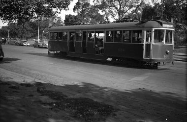
Negative, Wal Jack, 10/02/1941 12:00:00 AM
Black and white negative, by Wal Jack, of No.CW5 684 Batman Ave on its way to Burwood. Has the Yarra River and the Gardens in the background. The tram is well loaded. Photo dated 10-2-1941 in the Wal Jack album along with details of the location.trams, tramways, batman ave, cw5 class, burwood, tram 684, route 74, mmtb -
 Melbourne Tram Museum
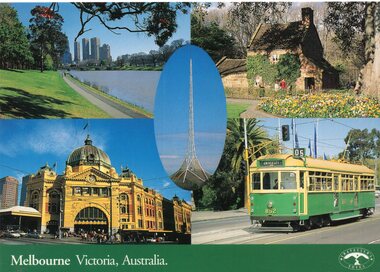
Postcard, Traveller's Notes, 4 panel full colour - by Traveller's Notes, 1997
Postcard - 4 panel full colour - by Traveller's Notes, of the Yarra River, Cook's Cottage, Flinders St Station main entrance, and SW6 852, University, route 5. Divided back, published by Traveller's Notes, photos by Neil J Leed, 1997.trams, tramways, flinders st station, yarra river, sw6 class, route 5, tram 852 -
 Kiewa Valley Historical Society
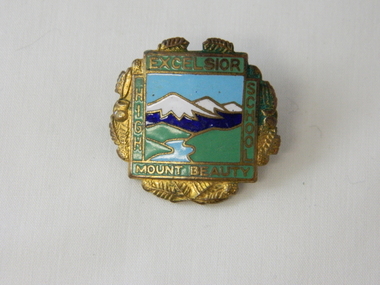
Badge Brass - Mt Beauty High School, circa 1970
Schools of this era were very proud of their identity. This was particularly so in country based ones. Schools in isolated or semi isolated regions provided social cohesion and pride and community involvement that was not so inherent in schools located in larger cities. The exception here being the Greater Public Schools. Mrs Beverly Johnson nee Davis designed the school badge.This badge was worn by a local girl, who has the spirit shown by many pupils from the Mount Beauty High School that the identity of belonging to a Kiewa Valley High School is a treasured part of life for them in this regional area. Mount Beauty High School badge made of brass. The front is coloured enamel depicting a scene of sky, mountains, grass and river. It is surrounded on four sides by the words Excelsior, Mount Beauty, High, School. The outside edges are decorated with gold colored fernsExcelsior, School, Mount Beauty, High On flip side K. G. Luke Melb.school badge, hat, lapel badge, high school memorabilia, brass badge -
 Lakes Entrance Historical Society
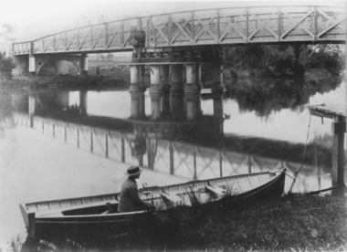
Photograph, Caire, Nicholas John, Swing Bridge Sale Victoria c1905, 1905c
Latrobe Bridge Sale Victoria in closed position . The operating machinery is still visibleBlack and white photograph of the Latrobe Bridge, in its closed position. The operating machinery is visible, plus the unique pier structure of the central span. In the rowing boat moored along side the river bank, a person wearing a boater hat is seated. Sale Victoriawaterways, bridges, civil engineering -
 Ballan Shire Historical Society
Map - Map. Moorarbool East and West, Country Lands in the Parishes of Moorarbool East and Moorarbool West. Counties of Bourke and Grant
This is a map of "Country Lands" around the Werribee River, north of Ballan in the Counties of Bourke and Grant.A relatively small map, paper on a material backing. Shows topographical features, roads and property divisions. Scale of forty chains to one inch. The map is dated March 31st, 1859.There is a small inscription under the chain scale that reads "No 58/364 John Phillips ? Survey 1st August 1858". The name Dugald McPherson is hand written on one of the blocks of land.moorarbool west, moorarbool east, dugald mcpherson, county of bourke, county of grant, werribee river, ballan -
 Port of Echuca
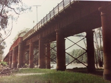
A rectangular coloured photograph, 1970?
This photograph shows the Echuca Moama bridge crossing the Murray River in the early 1970's. This photograph shows the Echuca Moama bridge in the early 1970's. It shows one of the rounded arches on the bridge. The rounded arches were the original arches and were at one stage replaced by square arches, but then replaced again by rounded arches.A rectangular coloured photograph of the Echuca Moama bridge taken from the Victorian bank, sometime in the early 1970's. One round bridge arch can be seen and a tall electricity pole can also be seen on top of the bridge. The vegetation on the Victorian bank is short and cropped. Some dead branches lie on the ground in the left foreground.There are none.echuca moama bridge, murray river, victorian bank -
 Eltham District Historical Society Inc
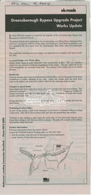
News Clipping, Advertisiing; Greensborough Bypass Upgrade Project Works Update, VicRoads, Diamond Valley Leader, 15 December 2004, 2004
Addition of second stage bridge over Plenty River and extension of ring road connectionNewsprintgreensborough bypass, road construction, vicroads -
 Greensborough Historical Society
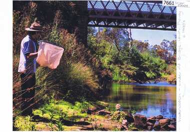
Photograph - Photograph (Copy), Anne Paul, Water Watch under old bridge, Lower Plenty 1990s, 1990s
Two views of "Waterwatch" working around the bridge over the Plenty River in Lower Plenty.2 colour photographs printed on paper, handwritten captionslower plenty, plenty river, waterwatch -
 Greensborough Historical Society
Article - Newspaper Clipping (copy), John Harrison, Original correspondence to the Editor, by John Harrison, 09/05/1842
Correction of a report made about the killing and capture of bushrangers raiding station on the Plenty River2 p. typescript copied from Port Phillip Patriot and Melbourne Advertiser 9 May 1842bushrangers, plenty river -
 Greensborough Historical Society
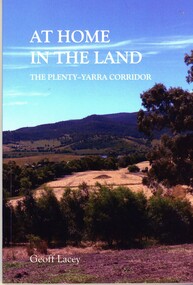
Book, Geoff Lacey, At home in the land: the Plenty-Yarra corridor, 2021
111 p., paperback, col. photographs, mapsnon-fictionindigenous plants, indigenous fauna, plenty river, yarra river -
 Greensborough Historical Society
Slide - Photograph, John Ramsdale, Encroaching suburbia: Slide 10, 1990s
Photograph shows encroaching residential looking from undeveloped to developed side of Plenty River.Part of the John Ramsdale collection of slides and audio visual material.Colour photograph scanned from slide.No maker's marks. No caption on slide.plenty river, residential development, urbanisation -
 Greensborough Historical Society
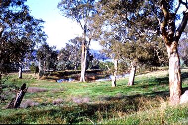
Slide - Photograph, John Ramsdale, Farmland Yallambie: Slide 49, 1990s
Photograph shows a rural landscape with gum trees and dam; this is near Yallambie on the Plenty River.Part of the John Ramsdale collection of slides and audio visual material.Colour photograph scanned from slide.No maker's marks. No caption on slide.plenty river, yallambie -
 Greensborough Historical Society
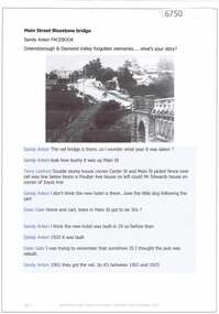
Article and Photograph, Main Street Bluestone bridge, 2017_
Information and photos about the bluestone bridge over the Plenty River in Main Street GreensboroughThis photograph and text was copied from a Facebook site. Members are people who lived in the Greensborough area and share their reminiscences of the area with others. The site is administered by a GHS member but is not officially affiliated with the Society. Any information is the opinion of the contributor. Article and photograph sourced from social media.bluestone bridge greensborough, plenty river, main street greensborough -
 Greensborough Historical Society
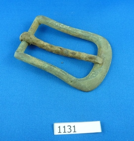
Buckle, 1880c
Metal buckle, possibly for horse gear. Found along Plenty River near Yallambie.Metal buckle, some rust.buckles, horse buckles, plenty river, yallambie -
 Greensborough Historical Society
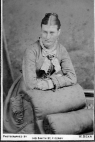
Photograph - Digital image, Mrs Mitchell, 1882c
Photograph of Mrs Mitchell. The Mitchell house was situated in Hailes Street on land that went to the river. Digital copy of black and white photograph.mitchell family -
 Greensborough Historical Society
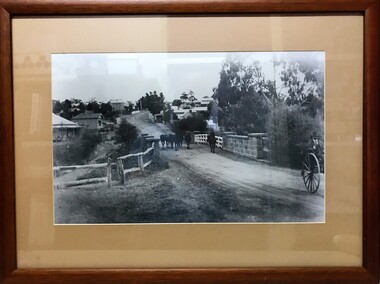
Photograph (Framed), Greensborough bridge, 1902-1925
View of bridge over Plenty River looking south up Main Street GreensboroughBlack and white photograph, mounted in wooden frame with glassValley Picture Framing, corner Church and Grimshaw Streetspioneer reserve greensborough, main street bridge