Showing 3609 items
matching street map
-
 Ballarat Tramway Museum
Map, Electric Supply Co. of Vic (ESCo), Ballarat Electoral Map - ESCo, 1900
Document prepared by the Electric Supply Co of Victoria, as part of an order under the Electric Light and Power Act 1896, section 5 of order No. 17 granted to company. Dated 19/2/1901 and signed by the Postmaster-General. Shows the order area being parts of the City of Ballaarat, Sebastopol and Ballarat East. Shows the street names, boundaries, principal power line routes, land reserves, parks, mine locations, railways and Lake Wendouree. Signed by R L Williams Town Clerk City of Ballarat, J R Hall for the Borough of Sebastopol, and John Gent for the Town of Ballarat EastYields information about the power supply to the Ballarat area.Cloth backed paper map, coloured and marked up as exhibit 17.Notes in ink including the signature of Benjamin Deakin 24/9/00 and certified by the three involved municipal Town Clerks.ballarat power supply, esco, electric supply co of victoria, city of ballaarat, east ballarat, sebastopol, orders, power lines, power supply -
 Moorabbin Air Museum
Map (Item) - Star Chart Adapted From Illyne's Star Chart
-
Moorabbin Air Museum
Document - Stress Report WRE Maps II in Pilatus Porter A/C, Weapons Research Establishment
-
 Ballarat Tramway Museum
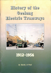
Book, David J. O'Neil, "History of the Geelong Electric Tramways", Jul. 1994
Eighty page book with heavy card covers A4 size. Colour covers with colour photo of No. 31 at Moorabool and Little Malop Streets, 1950. Contains index, notes on early Geelong Transport, Tramways, opening, decorated trams, Football and trams, People of the tramways, Conductresses, Tramway's staff, Yarns and Truthful (?) stories, The Tramway's Union, Closure, Tram car fleet disposal. Contains many black and white photos, stories and one map and plan of depot. Written by David (Dave) J. O'Neil On rear cover has a "Highton Newsagency" label with price of $24.95. Item scanned 28/4/2019 - btm1293i1.pdf to btm1293i3.pdf - three sections - text searchable when opened using a pdf editor.trams, tramways, geelong, provincial tramways, conductresses -
 Ballarat Tramway Museum
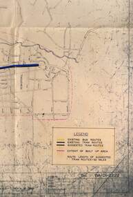
Map - Map/s, State Electricity Commission of Victoria (SECV), Ballarat bus routes, 1971
Set of five maps prepared by the SEC/Transport Regulation Board? reviewing the option for Ballarat bus routes after the closure of the Ballarat tramway system. Based on SEC drawing No. BA-D1-2222, drawn at 1" = 20 chains. Shows streets in Ballarat and Sebastopol areas. 1775.1 - tram lines shown in heavy blue lines, with grey and yellow (actual operating bus routes at the time?) routes marked out. A red dashed line defines the general built up area. 1775.2 - "PLAN A" - shows various routes in different colours for Davis, Sproule, Hick ex Whkes, Lyons, Braybrooks and Witkins services and existing tram lines. 1775.3 - "Plan B" 1775.4 - "Plan C" 1775.5 - "Plan D" 1175.6 - Plan as above, but showing existing bus routes, tram routes and suggested tram routes. Has a small sheet of paper that was clipped to the drawing. Not dated. Not known exactly the basis that these plans were drawn up on. Drawings to be scanned.trams, tramways, closure, bus routes, tram replacement, sec, transport regulation board, ballarat, tram routes -
 Ballarat Tramway Museum
Map, South Pacific Electric Railway, c1970's
702.1 Map of Sydney Trams - diagrammatic in 1921, includes electric and steam, shows streets, railways and where starting (Not original a reproduction) 702.2 - as above, but shows track layout, crossovers etc. - more to scale, also a reproduction. Image added 20-12-2016.trams, tramways, map, sydney -
Moorabbin Air Museum
Pamphlet (Item) - London to Australia Air Race 1969 - photos, results, maps
-
Moorabbin Air Museum
Newspaper (Item) - List of P40 Kittyhawks & Spitfire crashes, news clippings of Bombing of Darwin & Krait. PLUS Japanese invasion Map of Australia
-
Moorabbin Air Museum
Map (Item) - Middle East Egypt WW1 AFC Map
-
Moorabbin Air Museum
Photograph (Item) - Photos & Maps of First Air Board - plus early Qantas/TAA postcards & crop-duster pics
... Moorabbin Air Museum Moorabbin Airport 12 First Street ... -
Moorabbin Air Museum
Map (Item) - Visual Terminal Chart - Melbourne<>Adelaide
-
Moorabbin Air Museum
Map (Item) - Environs of the Top End Map
-
Moorabbin Air Museum
Drawing (Item) - Environs of the Top End Map
-
Moorabbin Air Museum
Document (Item) - The TAA Trans Australia Airlines Map of Australia
-
Moorabbin Air Museum
Map (Item) - Department of the Navy Hydrographic Office Air Navigation Chart No V30-57 South Pacific Ocean Australia and North East Seas and Islands
-
 Ballarat Tramway Museum
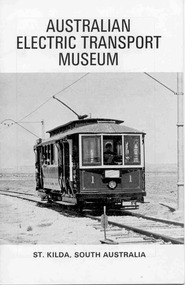
Book, Australian Electric Transport Museum (SA) Inc, "Australian Electric Transport Museum / St Kilda, South Australia", 1974
Thirty two page book, centre stapled, art paper, titled "Australian Electric Transport Museum / St Kilda, South Australia", guide book for the Museum, printed 1974. Gives information on AETM's exhibits, including ex Ballarat trams 21 and 34. Has maps of the AETM, Adelaide, Trolley buses system and brief history of Adelaide public street transport.trams, tramways, adelaide, trolley buses -
 Ballarat Tramway Museum
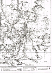
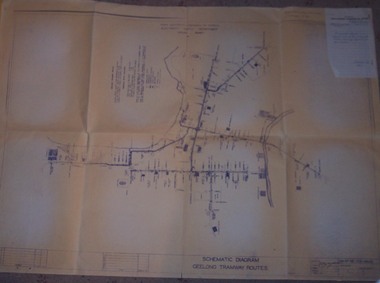
Drawing, State Electricity Commission of Victoria (SECV), "Schematic Diagram Geelong Tramway Routes", 1953
The drawing is very detailed showing streets, cross streets, route, loops, schools, woollen mills, ovals, sections, track phones, stops, route and track miles, pedestrian crossings, railway stations and notes on through route mileages.Print of a drawing showing in very good detail, the schematic layout of the Geelong Tram system. Produced in 1953 and sent to Tramway Supt. in 1970 for his records. Gives very detailed information on another SEC tramway system.Dyeline print of SEC Drawing No. GE-T13-8829, titled "Schematic Diagram Geelong Tramway Routes". Drawing prepared 27/8/1953. Stapled to the top right hand corner of the sheet is a SEC memo form from finance section, distribution services to the Dept. Tramway Superintendent, Ballarat, dated 6-2-1970 forwarding Les Denmead the plan. Was unstapled during the 1/2008 copying of the drawing. On top right hand corner of drawing, "Ballarat Tramway Preservation Society Catalogue No. 605" in ink and on rear in two places "Geelong Tramways" and one "BTPS 605"geelong, map, track layout, tram stops -
 Ballarat Tramway Museum
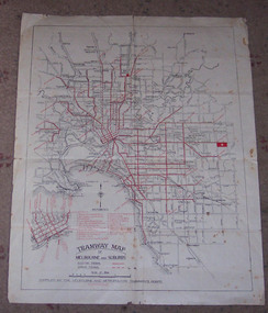
Map, Melbourne and Metropolitan Tramways Board (MMTB), "Tramway Map of Melbourne and Suburbs", 1930c
Two colour map of Melbourne tramway Network, undated, but post the conversion of Collins St to electric trams (late 1929), c1930. Shows both electric and cable lines, various locations, eg the Motordrome, railway lines and primary streets. Compiled by the MMTB.On rear in pencil over three locations "Young Asst Mgr", "Young" and "L Calder? 6 Inglis? Wahroonga"trams, tramways, mmtb, map, cable trams, conversion -
 Ballarat Tramway Museum
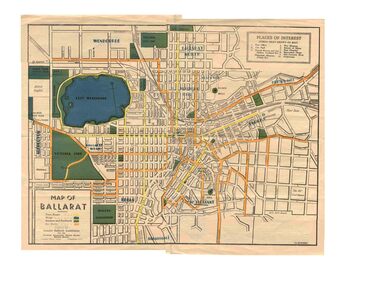
Map, Greater Ballarat Association and George Netherway, "Map of Ballarat", c1945
... Five colour map of Ballarat, showing streets, places... Greater Ballarat, including trams, buses, locations and streets ...Yields information about Greater Ballarat, including trams, buses, locations and streets. Has a strong association with George Netherway.Five colour map of Ballarat, showing streets, places of interest, Parks, tram routes, bus routes, railway lines, prepared by G. C. Netherway, Greater Ballarat Association, for the Victorian Government Tourist Bureau, Ballarat Branch, c1945. Shows suburbs names, location of orphanage, the lack of development north of Howitt St, in Wendouree. Map is part diagrammatic and is not entirely to scale. On rear is a road map of the Ballarat area, lists of statistics, beauty spots, look outs, art and culture, points of historical interest, industrial products and recreation. Note: Image 1, assembled from four scans, does not entirely match at edges. See Reg item 2074 for photographic image of another version map. See Reg Item 5613 for another version of this map. trams, tramways, ballarat, tram routes, bus routes, map, lists -
Moorabbin Air Museum
Map (Item) - airport maps Includes a tribunal letter about avoiding night flying test, Maps of Australian airports
... Moorabbin Air Museum Moorabbin Airport 12 First Street ... -
Moorabbin Air Museum
Map (Item) - RAAF Publication 103, Handbook of Administration in the RAAF
-
Moorabbin Air Museum
Manual (Item) - RAAF - With Map And Compass TG-74
-
Moorabbin Air Museum
Manual (Item) - RAAF Advanced Navigation Course - Maps And Charts.TG-53 Volume 1
-
Moorabbin Air Museum
Map (Item) - route map of Australia, ANA australian national airways
-
Moorabbin Air Museum
Map (Item) - Moorabbin airport scale drawing, Moorabbin airport
-
Moorabbin Air Museum
Map (item) - Silk Map Holland Belgium France Germany Switzerland Sheet C and D
... Moorabbin Air Museum Moorabbin Airport 12 First Street ... -
Moorabbin Air Museum
Map (item) - Map Gippsland
... Moorabbin Air Museum Moorabbin Airport 12 First Street ... -
Moorabbin Air Museum
Booklet (Item) - Instructions For The Preparation Of Weather Maps, With Tables Of The Specifications And Symbols
Air Ministry - Meteorological Office -
 Ballarat Tramway Museum
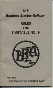
Book, Branford Electric Railway, "The Branford Electric Railway Timetable No. 9", 1977
Forty page booklet individual pages pinned within grey covers titled "The Branford Electric Railway Timetable No. 9", dated 1/3/1977, authorised by D. K. Bowers Superintendent of Transportation. Gives Emergency Information, contact numbers, definitions, rules, timetables, special instructions and a map of the rail line. .Published by the Branford Electric Railway (Pennsylvania USA) for information and training their crews, mid 1970'strams, tramways, instructions, training, street cars, rules -
 Ballarat Tramway Museum
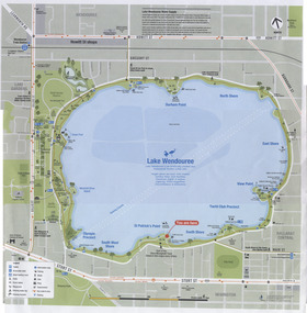
Map, City of Ballaarat, Lake Wendouree, 2010
Colour printed map of Lake Wendouree and surrounding streets showing walking paths, roads, tram, bus and rail lines and other features. Used in the large maps placed around the Lake c2009. Printed on an A3 size sheet. Two copies held.trams, tramways, map, lake wendouree, wendouree parade