Showing 10531 items
matching land
-
 The Beechworth Burke Museum Research Collection
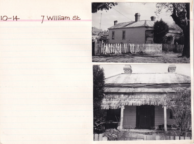
Card - Index Card, George Tibbits, 7 William St, Beechworth, 1976
Property - 7 William Street Beechworth, Section 10, Town Allotment 14, 100 x 250 Ownership details and history - 11 Apr 1856 - W.C. Hill 1857 F.J. Doull 1862 F.J. Doull, Land 33' x 165', Prem 21' x 13' x'9" / Prem 20' x 13'9" (occupier R. Nelson) 1866 - Land 33 x 165 Prem 20' x 13'9" slabs & bark, £7.10.0 1870 - T Dalziel - Land Only 66x165 1883 - Land Only Architectural Index Card - Brian Pump and Tony Dugan - Photographers beechworth, george tibbits -
 Dandenong/Cranbourne RSL Sub Branch
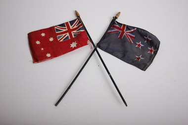
Flag - The Australian Red Ensign Flag and New Zealand Flag, unknown
Likely from WWIPair of miniature flags on small black flag poles with wooden caps. The Australian Red Ensign, or the Australian Civil Ensign, is simply a red version of the Australian National flag. It is for use only at sea and officially never on land, but can be used by private citizens. At sea, it is the only flag allowable for merchant ships registered in Australia under the Navigation and Shipping Act 1912 and The Shipping Registration Act 1981. Pleasure craft, however, may fly either the Red Ensign or the National Flag. The history of the Red Ensign is intertwined with the history of the Australian National flag. From 1901 to 1954 the Red Ensign was used as the National Flag by State and Local Governments, private organisations and individuals. The Blue Ensign was for Government use only, reflecting British practice with its ensigns. The design of the Australian Red Ensign was always kept in step with the Blue Ensign (i.e. with respect to the number of points on the stars, etc.) but there was often public confusion about which was the `correct′ flag to fly. Many thought the choice was merely one of fashion or preference. In 1941, Australia′s Prime Minister Robert Menzies stated that there should be no restrictions on private citizens using the Blue Ensign on land and, in 1947, Prime Minister Ben Chifley reaffirmed this position but it wasn’t until the passage of the Flags Act 1953 that the restriction on civilians flying the Blue Ensign was lifted after which, use of the Red Ensign on land became a rarity. Since 2008, 3 September has been officially commemorated as both Australian National Flag/Merchant Navy Day which allows the Australian Red Ensign to be flown on land for the occasion as a matter of protocol. The blue flag is the New Zealand National Flag.flag, ensign, anzac, new zealand, navy, naval -
 Monbulk Historical Society
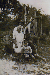
Thomas and Lillian Cavey with sons Tom and George
Thomas William Cavey was born in 1871, he was the youngest of his family and the only child that was born in Australia. He was first employed at the lime kilns in Geelong, before moving to Queensland for 4 years where he worked as a Boundary Rider. Thomas returned to the Lilydale area to be the driver of a buggy and pair for David Mitchell of David Mitchell Quarry in Lilydale. He selected land in Seamer Road in Monbulk in about 1898, but was working for the railways in Melbourne at the time and would come up to Monbulk at weekends to clear and cultivate the land. He met Lillian Eager, probably through relatives of hers, the Wingates, who lived in Monbulk. He and LIllian were married in 1910. They bought a 22 acre property in what is now called Cavey Road. They had two sons Thomas Charles, born in 1918 and George William Born in 1923. Initially the property in Cavey Road was farmed for vegetables, fruit and berries. The land used for this was over a creek on steep land away from the house. Once the produce was harvested it was taken by flying fox, back across the creek to where it could be prepared for sale. It was then taken to the Emerald and Belgrave markets each week. Later 10 cows were purchased, and the main income from the property was the dairy which produced approximately 25 quarts of milk a day, they produced Cream and Butter and together with the milk they were delivered fresh daily in the horse and cart. Deliveries were made to Monbulk, The Patch and to the canvas town at Silvan Dam, where the workers building the Silvan Dam lived. Thomas William Cavey died in 1959 aged 89. Lillian Blanche Cavey died in 1949 aged 68. -
![Aboriginal Natives of Victoria Hop Gathering / [by] Nicholas Caire, circa 1876](/media/collectors/550653872162f11fb04854aa/items/5783136dd0cdd1176c497cca/item-media/5783140ad0cdd1176c4a76ef/item-fit-380x285.jpg) Kew Historical Society Inc
Kew Historical Society IncPhotograph, Anglo-Australasian Photographic Company, Aboriginal Natives of Victoria Hop Gathering, c. 1876
Nicholas Caire was born on Guernsey in the Channel Islands in 1837. He arrived in Adelaide with his parents in about 1860. In 1867, following photographic journeys in Gippsland, he opened a studio in Adelaide. From 1870 to 1876 he lived and worked in Talbot in Central Victoria. In 1876 he purchased T. F. Chuck's studios in the Royal Arcade Melbourne. In 1885, following the introduction of dry plate photography, he began a series of landscape series, which were commercially successful. As a photographer, he travelled extensively through Victoria, photographing places few of his contemporaries had previously seen. He died in 1918. Reference: Jack Cato, 'Caire, Nicholas John (1837–1918)', Australian Dictionary of Biography.An original, rare photograph from the series 'Views of Victoria: General Series' by the photographer, Nicholas Caire (1837-1918). The 60 photographs that comprise the series were issued c. 1876 and reinforced a neo-Romantic view of the Australian landscape to which a growing nationalist movement would respond. Nicholas Caire was active as a photographer in Australia from 1858 until his death in 1918. His vision of the Australian bush and pioneer life had a counterpart in the works of Henry Lawson and other nationalist poets, authors and painters.Aboriginal Natives of Victoria hop gathering’ : Views of Victoria (General Series) No.50 : Albumen silver photograph | Photo on card with Title and Description on reverse | Mounted 24 x 30 cm; Photo 12 x 17 cm.On Reverse: ‘The growth of Hops has of late years occupied the attention of farmers in most of the colonies, and with the most encouraging results. It has been introduced with considerable success on most of the Aboriginal Stations in Victoria. Our illustration represents a group of natives gathering Hops on the Station at Bairnsdale, in Gipps Land.’nicholas caire (1837-1918), bairnsdale, aborigines, landscape photography, first peoples, aboriginal and torres straight islander -
 Emerald Museum & Nobelius Heritage Park
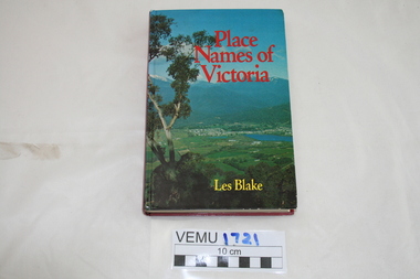
Book, Place Names of Victoria, 1977
The sequence of naming was a chronological representative of land discovery and settlement. Starting from the native population to the explorers, the squatters and settlers and surveyors during the gold rush. The term 'places' refers to physical features of the coast and land as well as districts, towns and cities.Hard Cover book written by Les Blake and first published in 1977. The jacket has a photograph of Mount Beauty and the Kiewa Valley from the Tawonga Gap.place names of victoria -
 Federation University Historical Collection
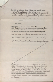
Documents, Appointment of New Trustees of the Ballarat School of Mines and Industries, 1894, 1894
A deed appointing the Reverend Samuel Thornton as a trustee of the Ballarat School of Mines, after the death of former Trustee Rivett Henry Bland, and increasing the number of trustees by appointing James Millhinch Bickett. It includes a covering letter of Department of Lands and Survey Letterhead... and whereas it is intended that forthwith after the execution hereof the said land and premises shall be so transferred that the same may become vested in the said Sir William John Clarke and John Warrington Rogers jointly with the said Right Reverend Samuel Thornton, Andrew Anderson and James Millhinch Bickett now these prexsents witness that the said Governor as such Governor as aforesaid in exercise of the power for this purpose given to him by the said Crown Grant and of every other power enabling him doth hereby appoint the Said Right Reverend Samuel Thornton to be a trustee of the land in place of the said Rivett Henry Bland and James Millhinch Bickett to the addition trustees. .. .department of lands and survey, letterhead, legal, john adrian louis earl of hopetoun, william john clarke, rivett henry bland, john warrington rogers, trustees, ballarat school of mines, ballarat school of mines trustees -
 Eltham District Historical Society Inc
Photograph, George Coop, A day in Melbourne, northwest corner, Mont Albert and Balwyn roads, November 1962, 1962
Modern building now on vacant block of land in frontDigital TIFF file Scan of 35mm Ilford FP3 black and white transparencybalwyn road, houses, melbourne, mont albert road -
 Moorabbin Air Museum
Booklet (Item) - International Civil Aviation Organization Airport Planning Manuals, Airport Planning Manual
Contains information about master planning and land use -
 City of Greater Bendigo - Civic Collection
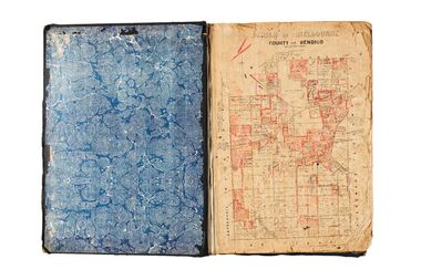
Administrative record - Land Sales, Department of Lands and Survey et al, 1929
This type of album was created by agents auctioning and selling land.Large portfolio style album with green cloth cover bound with three large metal pins. One hundred and then pages with thirty three Department of Lands and Survey maps pasted in. Index page. Maps have handwritten notes and markings throughout in pencil and pen. Covers the Counties of Bendigo, Rodney, Talbot, Gunbower, Gladstone, Tatchera and Karkarooc, Shires of East Loddon and Huntly and Swan Hill District. -
 City of Greater Bendigo - Civic Collection
Administrative record - Land Sales, A. J. Mullet Government Printer, 1927
This type of album was created by agents auctioning and selling land.Large portfolio style album with black cloth cover bound with three large metal pins. Blue marbled pastedown endpapers. Seventy nine pages, seventy five with Department of Lands and Survey maps attached. No index page. Maps have handwritten notes and markings throughout in pencil and pen. Covers the Counties of Bendigo, Rodney, Gladstone and Talbot and Parishes of Kerang, Salisbury, Mandurang and Tarnagulla. Includes a hand written note on William Wallace & Co letterhead. city of bendigo commerce -
 The Beechworth Burke Museum
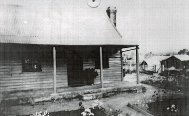
Photograph, c1900
This photograph shows a small timber house in Wooragee. In 1855, the Ovens district made a shift towards farming development that included the sales of land in the Wooragee Valley. This shift came because of miner's demands and concern about stabilising the area around the goldfield. Continual migration needed to be supported, unlucky diggers needed alternative employment, and there was a lack of affordable fresh produce available on the goldfields. Initially, the cost of land in areas like Wooragee was prohibitive, and miners chose to squat rather than overpay for poor land. Throughout the 1850s and 1860s, land reform was a key topic for miners and politicians, as they attempted to improve land access and protect financial interests. This photograph is an example of rural development in the Wooragee area, showing the cottage, tents, and garden beds. While the date is unknown, the image nevertheless links us to the 1850s-1860s story of rural development in Indigo Shire. Black and white rectangular photo, copy of original, printed on paper. wooragee, timber, timber cottage, corrugated iron, cottage, housing, tents, gardening, farming, farming and agriculture, construction, garden bed, flowers, verandah, squatting, tent, field -
Glen Eira Historical Society
Letter - Hopetoun, Hopetoun Street, 2, Elsternwick
A copy of a one page typed letter, from C J and T Ham of the Central Land Office to Florence M Cordner, dated 29/04/1904, providing a valuation of her property located at the corner of Glen Huntly Road and Hopetoun Street, Elsternwick. The valuation provides a description of the land, house improvements and architectural features and outlines possibilities for land subdivision. Noted on the document in pencil is 'From collection of Brighton Historical Society'.cordner florence mrs, glen huntly road, glenhuntly road, elsternwick, hopetoun street, moynsha, melrose, campbell a l, towers, verandahs, brick, stables, ham c j, ham t, c j & t ham, central land office, mansions -
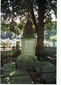 Whitehorse Historical Society Inc.
Photograph, Tombstone - Slater family
William Henry Slater emigrated from England and began growing medicinal herbs near Koonung Creek, Blackburn North in 1862. He also distilled eucalyptus oil for use at Melbourne Hospital and it was exported overseas under the 'O'Possum' brand. He later replanted his land with orchards but land taxes and rates forced the sale of the property. In 1979 the Nunawading Council purchased 7 acres of the land, now called , Slater ReserveColour photograph of the Slater family tombstone at Box Hill Cemetery. William Henry Slater died 23 May 1894 - 66 years of age Mary Ann Slater died 12 August 1912 - 83 years of ageslater, william henry, mary ann, herb farms, slater reserve -
Surrey Hills Historical Society Collection
Photograph, Opening of the footbridge across Back Creek, 1936, 1936
This photo was taken at the opening of the footbridge over Back Creek by Sir Winston Dugan, Governor of Victoria, in 1936. He is cutting bunting draped along the bridge rails. South Surrey Park was developed on land which had been the property of the Kleinert family. Their land extended from Union Road to Essex Road. They ran horses, ducks and fowls and Emily Kleinert grew flowers. Alan Holt research: Lot 6 was sold to Martin Klienert by Karl Richter in 1860 together with a portion of another adjacent lot. From 1860-1885 Martin worked it as a market garden leasing some land for grazing when it was not required for gardening. He died in 1898. In a formal document, William declared he was the son of Martin "who purchased land in 1860, died in 1898 and the land has been continually occupied by father and family since. It has been cultivated as a market garden; when not being used for gardening it was let for cultivation and grazing." William died in 1939 and the property passed to his sons Martin and Ernest. The family sold the land to the Camberwell Council in the 1950s.This photo is significant as it documents the change from rural to urban land use in the area.Black and white photo taken at the opening of the footbridge across Back Creek in the area later known as South Surrey Park. Back Creek runs diagonally through the photo with a wooden footbridge prominent. Dignitaries are gathered on the bridge. A tent and houses can just be distinguished in the background.parks and reserves, creeks, south surrey park, civic occasion, official events, back creek, verdun street, footbridges, governor of victoria, sir winston duggan, surrey hills, kleinert family, (mr) karl richter, (mr) martin kleinert, topography -
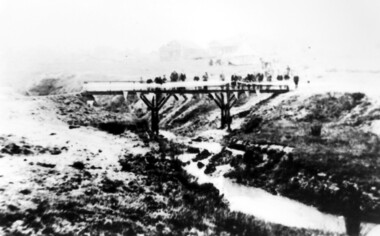 Surrey Hills Historical Society Collection
Photograph, Opening of the footbridge across Back Creek, 1936, 1936
This photo was taken at the opening of the footbridge over Back Creek by Sir Winston Dugan, Governor of Victoria, in 1936. He is cutting bunting draped along the bridge rails. South Surrey Park was developed on land which had been the property of the Kleinert family. Their land extended from Union Road to Essex Road. They ran horses, ducks and fowls and Emily Kleinert grew flowers. Alan Holt research: Lot 6 was sold to Martin Klienert by Karl Richter in 1860 together with a portion of another adjacent lot. From 1860-1885 Martin worked it as a market garden leasing some land for grazing when it was not required for gardening. He died in 1898. In a formal document, William declared he was the son of Martin "who purchased land in 1860, died in 1898 and the land has been continually occupied by father and family since. It has been cultivated as a market garden; when not being used for gardening it was let for cultivation and grazing." William died in 1939 and the property passed to his sons Martin and Ernest. The family sold the land to the Camberwell Council in the 1950s.This photo is significant as it documents the change from rural to urban land use in the area.Black and white photo taken at the opening of the footbridge across Back Creek in the area later known as South Surrey Park. Back Creek runs diagonally through the photo with a wooden footbridge prominent. Dignitaries are gathered on the bridge. A tent and houses can just be distinguished in the background.parks and reserves, creeks, south surrey park, civic occasion, official events, back creek, verdun street, footbridges, governor of victoria, sir winston duggan, surrey hills, kleinert family, (mr) karl richter, (mr) martin kleinert, topography -
Glen Eira Historical Society
Letter - Glen Eira Road, 138, Ripponlea
A copy of a two page valuation of 138 Glen Eira Road, Ripponlea (sic), Elsternwick, dated 25/08/1965. The valuation provides brief information about the size and location of the land, a general description of the factory present on the land and the final valuation.glen eira road, ripponlea, elsternwick, tullis r c, acacia street -
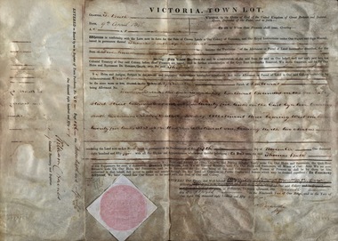 Federation University Historical Collection
Document, Grant, by Purchase, Ballarat, Victoria, 1856, 1856
Thomas Bath of Ballarat became the purchaser of a parcel of land for the sum of Five Hundred Pounds. The land was in the County of Grant, Parish of Ballarat. Record of Register of Town Purchase, No. 50, Page 156 on 20 April 1856 and signed by William C Haines.Thick cream paper, badly stained. Hanad written Official seal Dated 9 April 1856 Signed: E Macarthur - Major General Edward Macarthur Signed: William C Haines - Colonial Secretarythomas bath, county of grant, parish of ballarat, william c haines, colonial secretary, edward macarthur -
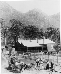 Halls Gap & Grampians Historical Society
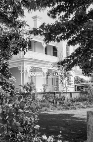
Photograph - B/W, C 1880
1880-1902 Land owned by Robert and Sarah Graham who owned a large portion of land best described as Upper Fyans Valley. At some time after 1880, they sold a parcel of the land under Sundial Peak to David Austin who built a slab hut. C1896, The land was sold to James and Amy Balmain which they named 'Bellfield' Amy was a daughter of John D/Alton who built the Stawell Water Supply System. Balmain purchased the vacant school cottage at Burnt Bridge and moved it to 'Bellfield' Over the next six years the house was enlarged to accommodate their growing family but sold in 1902 following the death of Amy Balmain.House with addition People leaving house by horse and carriage, people standing in groundsState Library Victoria, Rose's Australasian Views Victorian Series photographed and published by George Rose 123 Chapel St., Windsor, Victoriabuildings, houses, bellfield -
 Kiewa Valley Historical Society
Book - Kiewa Voters' Roll, Shire of Bright - Voters' Roll 1979 - Kiewa Riding, 1979
Electoral rolls list people who are registered and eligible to vote at federal, state, territory & local government elections and referenda. Prior to 1990 the rolls list voters in alphabetical order by surnames & first names within each Sub division of an electoral division of each State or Territory. The roll is useful & interesting for family historians and the study of demographics. Alex McCullough lived in the Shire of Bright and was on its Council. Electoral roles help to locate the residential address of a person in a particular year or over a period of years. They can be used as a substitute for census records for family historians and the history of a particular place in this case the Kiewa Valley - Tawonga and Tawonga South.Approx. 60 pages of firm yellow paper with black typed print on one side only in 'landscape' format. Held by three staples. Each page has column - numbered 1 to 943; Surnames in alphabetical order; Given names; Occupation; includes L (=land). Address followed by Lot number and parish. Includes Tawonga and Tawonga SouthOn the cover on the right hand side handwritten and difficult to read - "Jack? / Indi / Benambra / Nth Eastern / Division? of Dawson / 123 Victoria Rd. / Melbourne 3000"shire of bright; kiewa riding; voters roll; alex mccullough; tawonga; tawonga south -
 Footscray Community Arts
Toolum Boat, Bronwyn Bain, (exact); 2005
MEDIUM: Oil on canvas DESCRIPTION: Blue and white oil painting on canvas, no outer frame. An abstract interpretation of a boat in what appears to be the waters of the coast of Toolum, Mexico. The landscape of Toolum in Central America is dotted with the stark white washed remains of the ruins and temples of the Mayans. This depiction of a Toolum Boat reflects these relics of the land here on its watery gulf. "BB" signature; bottom proper right corneroil, bain, toolum, boat -
Glenelg Shire Council Cultural Collection
Booklet, Ambassador Press Pty Ltd, Granville, NSW 2142, 'The Emigrant's Friend' - facsimile, c. 1974
Booklet, originally published in London in 1848. Recreated by Reader's Digest, Sydney. Buff cardboard covers, 40 page booklet. Cover has depictions of seals of New Zealand, Australia, Swan River and Van Dieman's Land, one in each corner, charcoal, charcoal print 'THE EMIGRANT'S FRIEND, OR AUTHENTIC GUIDE TO SOUTH AUSTRALIA'; plus areas included in booklet. -
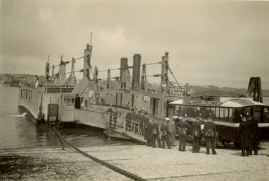 Federation University Historical Collection
Photograph - Photograph - Black and White, St. Hilda's Bus and band members boarding the Torpoint Ferry, on the River Tamar, 1934
Frank Wright was a renown resident of Smeaton, where he was born on 2 August 1901. He lived at Laura Villa, and attended Smeaton State School. His father William was a gold miner and his mother's name was Sarah. Their family won many singing and instrumental awards. Frank was tutored by Percy Code and was awarded a gold medal for the highest marks in the ALCM examinations in the British Colonies at the age of seventeen years. He became the Australian Open Cornet Champion by the age of eighteen. A year later, Frank conducted the City of Ballarat Band, and later the Ballarat Soldiers’ Memorial Band. He formed the Frank Wright Frisco Band and Frank Wright and his Coliseum Orchestra. These bands won many South Street awards, and Frank as conductor won many awards in the Australian Band Championship contest. In 1933 Frank Wright sailed to England to conduct the famous St Hilda’s Band and was later appointed Musical Director of the London County Council, where he organized many amazing concerts in parks, in and around the London district. He was made Professor of Brass and Military Band Scoring and conducted at the Guildhall of Music and Drama. Frank was often invited to adjudicate Brass Band Championships around Europe, in Australia, including South Street and in New Zealand. The Frank Wright Medal at the Royal South Street competition is awarded to an individual recognized as making an outstanding contribution to brass music in Australia.Black and white photograph of an early 1930's bus boarding a vehicle and passenger chain ferry. A group on men dressed in a band uniform are standing and watching the bus's progress. Land can be seen on both sides of the Tamar River. It is the Torpoint Ferry between Devonport in Plymouth and Torpoint in Cornwall. The men are the St. Hilda's Band, including Frank Wright, the conductor.Written in pencil on back - St Hilda's Bus on Torpoint Ferry between Devon and Cornwall, 1934frank wright, st hilda's band, st hilda's bus, brass band, torpoint ferry -
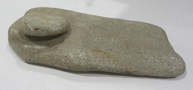 Federation University Historical Collection
Ethnographic Material, Stone grinding/sharpening tool
Stone grinding/sharpening tool with 'bump' which could be used as a handle. Evidence of wear due to sharpening on both sides of the stone. The rock is calcite cemented quartz sandstone; it is sedimentary quartzite with a granular appearance. It has a soft matrix, and is pale, indicating its calcite nature, as well as dissolved pits. Its origin is from dry land soils and dunes. aboriginal, stone, tool, archaeology, stone tools, sandstone, quartzite, calcite -
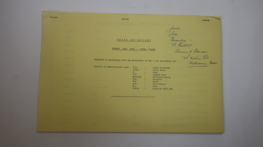
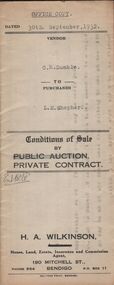 Bendigo Historical Society Inc.
Document - H.A. & S.R. WILKINSON COLLECTION: CONTRACT OF SALE
Conditions of sale by private contract dated 30th September, 1932 between C.R.Dumble (seller) and L,M. Shepherd (buyer) for land situate No.211 Forest Street, Bendigo being part of Crown allotment 367, section K described in certificate of title volume 2540 folio 507813, together with weatherboard dwelling and all sundry. Price 160 pounds.organization, business, h.a. & s.r wilkinson real estate -
 Bendigo Historical Society Inc.
Document - H.A. & S.R. WILKINSON COLLECTION: CONTRACT OF SALE
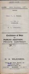
Conditions of sale by private contract dated 26th November, 1937 between Mrs. R.E. Mahon (seller) and N.L. Svanosio (buyer) for land situate in Sternberg Street, Bendigo, being lot 3 on plan of sub-division No. 13862, having a frontage of 60 feet by a depth of 107 feet. Price 40 pounds. Attached a drawing of the sub-division.organization, business, h.a. & s.r wilkinson real estate -
 Bendigo Historical Society Inc.
Document - H.A. & S.R. WILKINSON COLLECTION: CONTRACT OF SALE
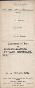
Conditions of sale by private contract dated 18th April, 1934 between G. Every (seller) and G.A. Tyers (buyer) for land situate White Hills Road, White Hills being part of Crown allotment 8 section 19, described in deed of conveyance No. 426 book No. 497, together with weatherboard dwelling and all sundry. Price 500 pounds.organization, business, h.a. & s.r wilkinson real estate -
 Bendigo Historical Society Inc.
Document - H.A. & S.R. WILKINSON COLLECTION: CONDITION OF SALE
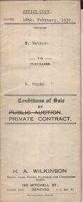
Conditions of sale by private contract dated 10th February, 1930 between T. Watson (seller) and R. Rigby (buyer) for land situate corner Milroy and Harrison Streets, Bendigo, being Crown allotment 405 section K described in Crown grant volume 1345 folio 268824, together with all buildings on said property. Price 650 pounds.organization, business, h.a. & s.r wilkinson real estate -
 Bendigo Historical Society Inc.
Document - H.A.& S.R. WILKINSON COLLECTION: CONDITION OF SALE
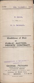
Conditions of sale by private contract dated 6th. September, 1926 between F. Blair and F. C. Neivandt for land situate corner of Buckley and Reviere Streets, Ironbark, certificate of registration No. 20917 together with 5-roomed weatherboard and german brick dwelling for the price of 202 pounds and 10 shillings. With the contract a receipt dated 9th September, 1926detailing the payment.organization, business, h.a. & s.r wilkinson real estate -
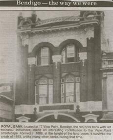 Bendigo Historical Society Inc.
Newspaper - JENNY FOLEY COLLECTION: ROYAL BANK
Bendigo Advertiser ''The way we were'' from 2000. Royal Bank: located at 17 View Point, Bendigo, the red-brick bank with 'art nouveau' influences, made an interesting contribution to the View Point streetscape. Formed in 1889, at the height of the land boom, it survived the crash of 1893, unlike many other banks during that time. The clip is in a folder.newspaper, bendigo advertiser, the way we were -
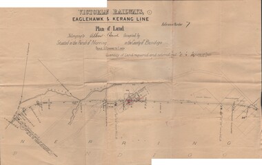 Bendigo Historical Society Inc.
Document - BUSH COLLECTION: PLANS PERTAINING TO LAND OF S. A. BUSH
A: Plan of subdivision of Allots 6, 7, 8, 15 & 16, Sec. 62C, City of Bendigo (The Property of Albert Bush, Esq.) - Plan is torn in half forming two pieces (see 'Condition'. Pinned note attached to one piece. B: Victoria Railways, Eaglehawk & Kerang Line (Albert Bush land, Parish of Nerring, County of Bendigo.person, individual, bush collection - personal