Showing 10533 items
matching lander
-
 Greensborough Historical Society
Newspaper Clipping, Diamond Valley Leader, Club tees to another five years, 12/06/2018
Strathallan Golf Club has holed out on the 18th, securing a five year lease for its golf course just months before it would have been kicked off the land.News article 1 page, black text.strathallan golf club, latrobe university -
 Greensborough Historical Society
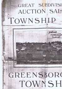
Plan, Greensborough Township Estate, 01/09/1923
Sub-division into 129 lots of land belonging to the Scotland Family, bounded by William Street, Eliza Street, James (Jessop) Street and south of Lorimer Street. Auction 1 September 1923Photocopy, double-sidedsubdivision plans, greensborough township estate, scotland family -
 Greensborough Historical Society
Bottle and Apron, Primary Edge Promotions, Medhurst Bottle and Apron, 2016_
Medhurst Wines operates in Gruyere, Yarra Valley. The winery is on land once owned by David Medhurst, formerly of Greensborough. These items were a gift to David's descendant, Faye Fort (nee Partington).Clear glass wine bottle 750 ml, screw cap, in black cardboard presentation box in red and white gift bagLabelled Medhurst Chardonnay 2016 Yarra Valley; with, black poly cotton apron, with pocket, embroidered Medhurst in white.medhurst family, medhurst wines yarra valley -
 Greensborough Historical Society
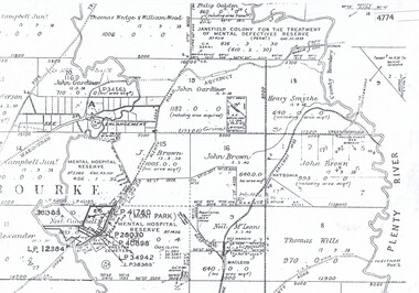
Maps, Greensborough west of Plenty River, 1840o
Areas of Greensborough, west of the Plenty River, showing land holdings in the 1840s. Comprises Sections 8, 9, 10, 14, 15, 16, 17, 18, 19, 20 Parish of KeelbundoraOne A4 photocopy, one A3 enlargementgreensborough, watsonia, lower plenty, janefield -
 Glenelg Shire Council Cultural Collection
Pamphlet - Brochure, Steam Packet Inn, n.d
The Steam Packet Inn is the second oldest building in Portland. It was licensed to an ex convict from Van Diemens Land (Tasmania) in 1841. Later became a police barracks. It is a heritage listed buildingYellow card, tri-fold brochure, containing history of Steam Packet Inn, Bentinck St. Portland. Photo of steam Packet Inn on front of brochure, floor plans on the back.steam packet inn, bentinck street, portland -
 Halls Gap & Grampians Historical Society
Photograph - B/W
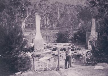
Jack and Amy McKeon's house burnt out remains, their house was set back from the what is now called Grampians Rd, on land between Grand Canyon Motel And Tim's Place.Site of burnt out residence. Two brick chimneys and a tank remain standing. Two fir trees in foreground on the fence line. Man holding a dog near post of the gate and bicycle lean against the wire fence . A road and power lines cross the picture beyond the site,backed by gum trees.buildings, houses -
 Eltham District Historical Society Inc
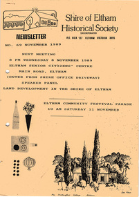
Newsletter, Newsletter, No. 69 November 1989
Contents: • Next meeting, Speaker Panel: Land Development in the Shire of Eltham • November Meeting • Recent Activities • Eltham Community Festival • Flavour of Eltham • Other Things You Should Know The Shire of Eltham Historical Society was formed in October 1967. The first newsletter of the Society was issued May 1978 and has been published continuously ever since on a bi-monthly basis. With the cessation of the Shire of Eltham in late 1994, the Society's name was revised to Eltham District Historical Society and this name first appeared with issue No. 103, July 1995. The collection of the Society's newsletters provides a valuable resource on the history of the Society's activities, office bearers and committee members, guest speakers and subjects of historical interest pertinent to the former Shire of Eltham and the Eltham District.A4 photocopied newsletter distributed to membersnewsletter, eltham district historical society, shire of eltham historical society -
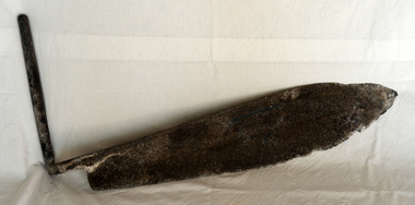 Orbost & District Historical Society
hay knife, c. 1900 - 1950
Used in agriculture in the Orbost district, to cut hay or silage, most likely on the Mundy farm. The original Mundy family moved to a land "selection" at Betebolong in the early 1880's from Buchan. A large flat iron blade with an iron handle attached. The blade is sharper on the bottom side and shows some evidence of perhaps having been serrated.agricultural-implement hay-silage-knife -
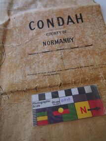 Bunjil Park Aboriginal Education & Cultural Centre
Map, Original titles map of Lake Condah and surrounds, Condah, County of Normanby
This map shows the area around Lake Condah including the land identified as Aboriginal Reserves. Aboriginal people including the Jaara were forcibly removed from their country and resettled in reserves like this. This map is significant as it shows one of the areas that Jaara people were forcibly removed to from their homelands. -
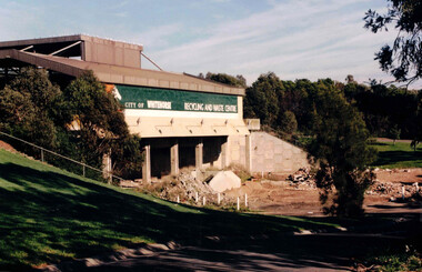 Whitehorse Historical Society Inc.
Photograph, Waste Transfer Station
The waste centre is situated next to Dandenong Creek and opposite Mahoneys Road Vermont South. Land fill was used until the 1980's when Whitehorse joined the "least Waste" program.Coloured photograph of the City of Whitehorse Recycling & Waste Centre, rear view. Situated in Vermont South near Dandenong Creekwaste transfer station, whitehorse transfer station, waste, recycling -
Bialik College
Document (Collection) - Israel Kipen collection, Box 2
1960s1960s -
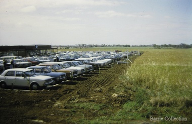 Melton City Libraries
Photograph, West Melton Regional Shopping Centre, 1973
Kilpatrick house which stood on the site until the 1970s on the land now occupied by the Regional Shopping Centre later to be renamed Woodgrove. Opening of the Centre views from the parking areas and paddocksOpening of the West Melton Regional Shopping Centre taken from the carparklocal significant events, local identities -
 City of Kingston
Pamphlet - Colour, Brock Bros, South Brighton Township Estate, 1888
Sales plan for land in the suburb of South Brighton (Moorabbin), bounded by Point Nepean Road, South Road, Patterson Street and the Mordialloc Railway Line. Incorporates Wolsely Street and Gordon StreetThe developing urban area of Moorabbin within the City of Kingston. This land sale pamphlet illustrates the subdivision of land within the municipality and the changing demographic of the district as new houses are constructed close to infrastructure.Colour pamphlet advertising for private sale the South Brighton Township Estate, South Brighton. Incorporates a map of the estate bordered by Point Nepean Road, South Road, Patterson Street, and the Mordialloc Railway Line. Includes Wolsley Street and Gordon Street. land sales, south brighton, estate, moorabbin -
 City of Moorabbin Historical Society (Operating the Box Cottage Museum)
Document - Genealogy Chart Henry Dendy (Photocopy), 19 thC
In 1840 Henry Dendy, a farmer in Surrey, England acquired a "Special Survey" from the Commissioners for Land and Emigration which gave Dendy the right to choose land in Port Phillip for the "bargain basement" price of only £1 per acre for 5120 acres, (an area of 8 square miles). The Special Survey also included the right to "the shipment of a worker for every £20 spent on land, whose free passage was paid by the Crown, equalling a total of 100 workers ". Accordingly Dendy sold his English holdings and paid the required £5120 and arrived in Melbourne in February 1841. However by this time land in the new colony was selling for £5 - £40 per acre. Because Henry Dendy possessed the order from the Colonial Office in London he was able to successfully oppose Super-intendant LaTrobe's attempts to alter the price of the land. Dendy appointed Jonathan Were, (an entrepreneur, who had arrived in 1839), as his Manager and who later became a partner. Together, Dendy and Were decided on an area 5 miles south from Melbourne, bounded by North Road, East Boundary Road, South Road and to the west by Port Phillip Bay. Were and Dendy pitched their tents in the area now known as ' Park St, Brighton' and sank a well near the corner of 'St Andrew's St and Wells St'. By 1845 J.B Were and Company had bought almost half of Dendy's land and Were built himself "Moorabbin House" in Were St Brighton made from stone, quarried from local cliffs. It was still standing in 1924. Legend records Moorabbin is named after the Aboriginal word for ' Mother's Milk ' The soil is very fertile and well supplied with water especially in the area called 'East Brighton' - now known as Bentleigh and East Bentleigh - By 1850 the area had developed with numerous market gardens, dairy farms, fruit gardens and vineyards supplying food for the growing population of Melbourne.In 1840 Henry Dendy, a farmer in Surrey, England acquired a "Special Survey" from the Commissioners for Land and Emigration which gave Dendy the right to choose land in Port Phillip for the price of only £1 per acre for 5120 acres. This land was called Brighton in the Parish of Moorabbin, County of Bourke and emigrants developed the land establishing market gardens , dairy and poultry farms that provided the food for the growing population of Melbourne. A photocopy of the Genealogy Chart of the Dendy Family that Henry Dendy brought with him when he emigrated to Melbourne 1841Genealogy signs and descriptionsdendy henry, dendy's special survey brighton 1841, governor gipps, captain lonsdale, super-intendant latrobe, port phillip, melbourne, new south wales, squatters, emmigrants, county of bourke, parish of moorabbin, early settlers, pioneers, market gardeners, dairy farmers, fruit farms, moorabbin, bentleigh, brighton, cheltenham, were jonathan binn, -
City of Moorabbin Historical Society (Operating the Box Cottage Museum)
Document, Henry Dendy family Shield
In 1840 Henry Dendy, a farmer in Surrey, England acquired a "Special Survey" from the Commissioners for Land and Emigration which gave Dendy the right to choose land in Port Phillip for the "bargain basement" price of only £1 per acre for 5120 acres, (an area of 8 square miles). The Special Survey also included the right to "the shipment of a worker for every £20 spent on land, whose free passage was paid by the Crown, equalling a total of 100 workers ". Accordingly Dendy sold his English holdings and paid the required £5120 and arrived in Melbourne in February 1841. However by this time land in the new colony was selling for £5 - £40 per acre. Because Henry Dendy possessed the order from the Colonial Office in London he was able to successfully oppose Super-intendant LaTrobe's attempts to alter the price of the land. Dendy appointed Jonathan Were, (an entrepreneur, who had arrived in 1839), as his Manager and who later became a partner. Together, Dendy and Were decided on an area 5 miles south from Melbourne, bounded by North Road, East Boundary Road, South Road and to the west by Port Phillip Bay. Were and Dendy pitched their tents in the area now known as ' Park St, Brighton' and sank a well near the corner of 'St Andrew's St and Wells St'. By 1845 J.B Were and Company had bought almost half of Dendy's land and Were built himself "Moorabbin House" in Were St Brighton made from stone, quarried from local cliffs. It was still standing in 1924. Legend records Moorabbin is named after the Aboriginal word for ' Mother's Milk ' The soil is very fertile and well supplied with water especially in the area called 'East Brighton' - now known as Bentleigh and East Bentleigh - By 1850 the area had developed with numerous market gardens, dairy farms, fruit gardens and vineyards supplying food for the growing population of Melbourne. dendy henry, dendy's special survey brighton 1841, governor gipps, captain lonsdale, super-intendant latrobe, port phillip, melbourne, new south wales, squatters, emmigrants, county of bourke, parish of moorabbin, early settlers, pioneers, market gardeners, dairy farmers, fruit farms, moorabbin, bentleigh, brighton, cheltenham, were jonathan binn, -
 City of Moorabbin Historical Society (Operating the Box Cottage Museum)
Document - Pedigree of Henry Dendy, c1840 Original ; Copy 1985
This is a copy of the document brought by Henry Dendy to the Colony in 1841. In 1840 Henry Dendy, a farmer in Surrey, England acquired a "Special Survey" from the Commissioners for Land and Emigration which gave Dendy the right to choose land in Port Phillip for the "bargain basement" price of only £1 per acre for 5120 acres, (an area of 8 square miles). The Special Survey also included the right to "the shipment of a worker for every £20 spent on land, whose free passage was paid by the Crown, equalling a total of 100 workers ". Accordingly Dendy sold his English holdings and paid the required £5120 and arrived in Melbourne in February 1841. However by this time land in the new colony was selling for £5 - £40 per acre. Because Henry Dendy possessed the order from the Colonial Office in London he was able to successfully oppose Super-intendant LaTrobe's attempts to alter the price of the land. Dendy appointed Jonathan Were, (an entrepreneur, who had arrived in 1839), as his Manager and who later became a partner. Together, Dendy and Were decided on an area 5 miles south from Melbourne, bounded by North Road, East Boundary Road, South Road and to the west by Port Phillip Bay. Were and Dendy pitched their tents in the area now known as ' Park St, Brighton' and sank a well near the corner of 'St Andrew's St and Wells St'. By 1845 J.B Were and Company had bought almost half of Dendy's land and Were built himself "Moorabbin House" in Were St Brighton made from stone, quarried from local cliffs. It was still standing in 1924. Legend records Moorabbin is named after the Aboriginal word for ' Mother's Milk ' The soil is very fertile and well supplied with water especially in the area called 'East Brighton' - now known as Bentleigh and East Bentleigh - By 1850 the area had developed with numerous market gardens, dairy farms, fruit gardens and vineyards supplying food for the growing population of Melbourne. A copy of a paper chart of the Pedigree of Henry Dendy in a wooden frame with glassPedigree / of the branch of the family / DENDY moorabbin, brighton, henry dend special survey 1841 y, early settlers, pioneers, market gardeners -
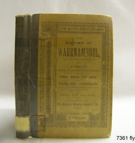 Flagstaff Hill Maritime Museum and Village
Book - Historical, Richard Osburne, The History of Warrnambool, 1887
This little book is one of only 1000 books published of the original Queen's Jubilee Edition. It spans fifty years of the history of Warrnambool from the time that the first Government Land Sales commenced. It also deliberately coincides with the 1887 celebrations of Queen Victoria's Jubilee Year of her ascension to the British Throne. The book is an invaluable reference for researchers of local Warrnambool history and has been used as a text book and reference book for local students. The book had two owners before it became part of the Warrnambool Public Library, and when the library closed down, the book was held by the Warrnambool City Council until, in 1974, it was transferred to the newly established Flagstaff Hill Maritime Museum and Village. The author, Richard Osburne, (1825-1895) was born in Australia. He moved to Warrnambool in 1847 as the first local Journalist. In 1851 he founded the Warrnambool Examiner newspaper which he operated until the end of 1880. Osburne was much involved in civic and community affairs of the town, and he set himself the task of recording the history of the city's early pioneers. In the introductory pages of the book the author refers to himself as "The Father of the Warrnambool Press". Only 1,000 copies of this edition of the book were printed. In September 1980 a facsimile edition was printed with the addition of illustrations from the period, an index and relevant annotations by local historian T.A. Wicking (Tom Wicking). This later book was named the Premier Town Edition, due to Warrnambool being awarded the title of Premier Town in Victoria in 1979-82 by the Premier of Victoria; it also received the inaugural award in 1959 and a later award in 1988-91. This book is rare. It is one of only 1000 copies printed, and one of three in the Collection of Flagstaff Hill Maritime Museum and Village. The book was dedicated to the early colonists as well as to the new arrivals by the writer, Richard Osburne, who entitles himself as "The father of the Warrnambool Press". The content of the book is invaluable as a reference for Warrnambool and District's local history in its early colonial and pioneering days. It provides the information that helps in an understanding the foundation that the city was built on, connecting the people of today to the pioneers of the past. The inscriptions of two previous owners of the book, at least one of whom was a local resident, gives additional significance to this copy. The History of Warrnambool: Capital of the Western Ports of Victoria From1847 (when the first Government Land Sales took place) up to the end of 1886, By Richard Osburne, Proprietor of the Warrnambool Examiner from 1851 to the close of 1880. Author: Richard Osburne Publisher: Prahran: The Chronicle Printing & Publishing Company Limited Date: 1887 (MDCCCLXXXVII) Edition: Original: Queen's Jubilee Edition Small book with hard cover and reinforced spine. Dust jacket front has been pasted over front hard cover. The hardcovers are covered with clear adhesive plastic covering. Inscriptions include a typed label on the spine, a stamp at base of the fly page, on the loose page inside front cover, on inside back cover, and two hand written names on the second fly page; Jackson Giblett and G. M. Potter. The first fly page has a message to the readers, as shown in the Inscriptions of this record.Label on spine "R.A. 994.57 OSB" Inscriptions on second fly page: "Jackson Giblett / 1886" and "G.M. Potter, 70 Japan Street" Printed on fly page: "PRICE, FIVE SHILLINGS" Stamp of front end paper: WARRNAMBOOL / PUBLIC LIBRARY", "000336" and in a rectangular border " - - - - - - / WARRNAMBOOL / PUBLIC LIBRARY" First fly page: "THE QUEEN'S JUBILEE EDITION. TO OLD COLONISTS AND YOUNG AUSTRALIANS, OR NEW ARRIVALS, THIS HISTORY OF THE RISE AND PROGRESS OF THE CAPITAL OF WESTERN VICTORIA, IS DEDICATED AS INTERESTING AND USEFUL, BY "THE FATHER OF THE WARRNAMBOOL PRESS" RICHARD OSBURNE." Stamp inside back cover: "WARRNAMBOOL LIBRARY/ Liebig Street / Warrnambool 3280 / (055) 6- 2258"warrnambool, shipwreck coast, flagstaff hill, maritime museum, maritime village, the history of warrnambool, richard osburne, osturne's history of warrnambool, queen's jubilee edition, 1847-1887, warrnambool history, the chronicle printing and publishing company, capital of the western ports of victoria, first government land sales, warrnambool examiner, five shillings, warrnambool's first reporter, warrnambool public library, 1887, 1979, premier town, premier edition, queen's jubliee, queen victoria's jubilee, western ports of victoria, 1847, government land sales, chronicle publishing and printing co., g m potter, 1000 copies, t a wicking, jackson giblett, 1886, japan street, old colonists, young australians, new arrivals, rise and progress, capital of western victoria, interesting and useful, the father of the warrnambool press -
 Melbourne Tram Museum
Photograph - Digital Image, Kevin O'Reilly, "Kew Burke Rd' looking at the East Kew Tram terminus, c1925
Image from CD (Compact Diskette for use in computers) - see Reg Item 135. Image titled "Kew Burke Rd' on CD, of looking at the East Kew Tram terminus with the city skyline in the background, c1925. Photo published in the Bellcord No. 16, Oct. 2012. From the article with the photograph; The terminus was located at the intersection of High St, Burke, Kilby and Doncaster Roads. We are at the outer edges of Melbourne’s suburbia at the time, unlike the current tram terminus of today. Burke Road, north of Doncaster Road is clearly under construction in preparation for the new river crossing. The vacant block of land in the foreground will remain so for another ten years or so. In 1960 the new Dickens Supermarket was built on this site and the intersection became known locally as Dickens Corner. The narrow track on the left hand side of the photo is Doncaster Road. The tram at the terminus is a straight-sill single trucker of one of the G, K, Q or R classes. It is finished in the late MMTB chocolate and cream livery. A cable grip car body has been placed as a tram shelter at the terminus. The church was subsequently relocated to Francis Street Yarraville where it still stands today as a private residence. Behind the large hedge on the south side of High Street is Smith’s Dairy. Part of this land would be sold to the MMTB for a planned new tram depot Behind the large hedge on the south side of High Street is Smith’s Dairy. Part of this land would be sold to the MMTB for a planned new tram depot but by the early 1960s it was transferred to the Education Department for construction of the Kew High School. The last portion of the dairy closed in the 1970s.trams, tramways, kew, burke rd, east kew, doncaster rd -
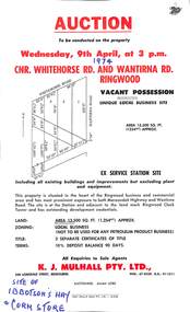 Ringwood and District Historical Society
Flyer, Flyer advertising auction sale of ex service station site in Ringwood, Victoria - 1974
Single page advertisement for auction sale of restricted business site, corner of Whitehorse Road and Wantirna Road, Ringwood, Victoria, on Wednesday, 9th April (1974).Advertisement includes location map and terms of sale of 3 separate certificates of title on land zoned as Restricted Business (Not to be used for any petroleum product business). Sole Agents - K.J. Mulhall Pty. Ltd., 358 Lonsdale Street, Melbourne (Telephone) 67 8338, A.H. 91 1511. Auctioneer - Allan Lord. Handwritten notation describes this as originally the site of Ibbotson's Hay and Corn Store. -
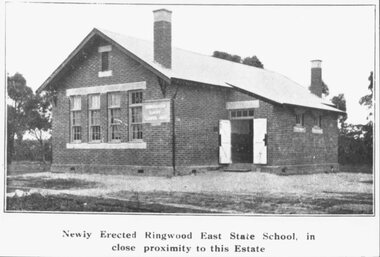 Ringwood and District Historical Society
Photograph, Newly Erected Ringwood East State School, Everard Road, 1925 (Two Photographs)
Printed below photograph, "Newly Erected Ringwood East State School, in close proximity to this Estate". Written on back of photograph, "Photo taken from Sub. Div. plan Land Sale 1st November 1924. Ringwood East Electric Station Estate, 1st November 1924. School Everard Road". Typed below another copy: "Ringwood East S.S. On completion 1925". -
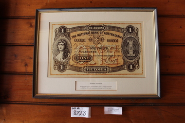 Coal Creek Community Park & Museum
Nation Banknote Display
8728.1 - Thin wooden frame with very dark stain and gold paint on the inner part of the frame. 8728.2 - Very large print of a one pound note. 8728.3 - Brief description of the note and it's history.8728.2 - 1 - MELBOURNE - VICTORIA - ONE - POUND - THE NATIONAL BANK OF AUSTRALIA LIMITED - On demand I promise to pay the bearer ONE POUND sterling at MELBOURNE June 1893 - For THE NATIONAL BANK OF AUSTRALIA - Manager - ENTd 8728.3 - NATIONAL BANK NOTE - The first note issued by the National Bank when it reopened for business on 26th June, 1893 after reconstruction following the 1893 land boom. -
![Waterfall Scene Near the Buchan River / [by] Nicholas Caire, circa 1876](/media/collectors/550653872162f11fb04854aa/items/57825da5d0cdd1176ce3ed3d/item-media/57825e03d0cdd1176ce418cf/item-fit-380x285.jpg) Kew Historical Society Inc
Kew Historical Society IncPhotograph, Anglo-Australasian Photographic Company, Waterfall Scene Near the Buchan River, c. 1876
Nicholas Caire was born on Guernsey in the Channel Islands in 1837. He arrived in Adelaide with his parents in about 1860. In 1867, following photographic journeys in Gippsland, he opened a studio in Adelaide. From 1870 to 1876 he lived and worked in Talbot in Central Victoria. In 1876 he purchased T. F. Chuck's studios in the Royal Arcade Melbourne. In 1885, following the introduction of dry plate photography, he began a series of landscape series, which were commercially successful. As a photographer, he travelled extensively through Victoria, photographing places few of his contemporaries had previously seen. He died in 1918. Reference: Jack Cato, 'Caire, Nicholas John (1837–1918)', Australian Dictionary of Biography.An original, rare photograph from the series 'Views of Victoria: General Series' by the photographer, Nicholas Caire (1837-1918). The series of 60 photographs that comprise the series was issued c. 1876 and reinforced a neo-Romantic view of the Australian landscape to which a growing nationalist movement would respond. Nicholas Caire was active as a photographer in Australia from 1858 until his death in 1918. His vision of the Australian bush and pioneer life had a counterpart in the works of Henry Lawson and other nationalist poets, authors and painters.‘Waterfall scene near the Buchan River’ : Views of Victoria (General Series), No.39 : Albumen silver photograph | Photo on card with Title and Description on reverse | Mounted 24 x 30 cm; Photo 12 x 17 cm.On Reverse: ‘The Buchan River is a tributary of the great Snowy River, which extends itself from Port Ricardo, on the Gipps Land coast, to considerably beyond Mt. Kosciusko, in New South Wales. It is comparatively but a stream, but, like most of the smaller rivers in Victoria, it contains some beautiful scenery, peculiar to itself. Our present illustration is characteristic of its scenery, and is taken from a creek close to the River.’nicholas caire (1837-1918), buchan river, landscape photography - victoria -
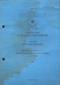 National Vietnam Veterans Museum (NVVM)
Booklet, Australian Army, Australian Army: Manual of Land Warfare, Part Two, Infantry Training volume 4 Pamphlet No 3: the Sub Machine Gun 9 mm F1 (All Corps) 1983:, 1983
A blue coloured cardboard cover which has signs of water damage on it and it is slightly buckled. Under the Australian Army Insignia is the niformation in black ink. Top right hand corner reads 7610-66-107-6806. There are two punch holes down the left hand side.There is a name in blue ink which I think reads Sgt Raynant, D. F. The description of the cover is different to the one inside of the cover which reads: Australian Army: Manual of Land Warfare. Part Two Corps Doctrine Infantry Training Volume 4 Infantry Small Arms. Pamphlet No 3 The Sub Machine Gun 0 mm F1 (All Corps) 1983australia - armed forces - service manuals, land warfare, infantry training, sub machine gun 9mm f1, corps doctrine, infantry small arms -
Glen Eira Historical Society
Document - Helenslea, Shelford CEGGS
One page of undated and unattributed handwritten notes regarding the grant of Helenslea land to Sir George Stephen and providing assessment numbers and information on the number of rooms and occupants of Helenslea for the period 1860 to 1889.hood judge, stephen george sir, helenslea, land subdivision, caulfield north, hood crescent -
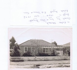 Greensborough Historical Society
Photograph - Photograph (copy), 11 Ester Street Greensborough, 1972
11 Ester Street Greensborough was owned by Ivy and Des Bryant. Bought in 1964 and sold 1972. Estate agent R.H .Dean and Son. The land has since been subdivided and units built.Copy of black and white photographCaption written on copybryant family, ester street greensborough -
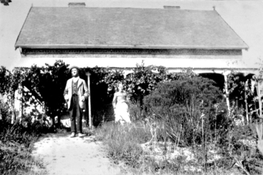 Greensborough Historical Society
Photograph - Digital image, Charles and Ellen Partington at Willis Vale, 1878c
Photograph of Charles and Ellen (nee Whatmough) Partington at the family home "Willis Vale" on the Plenty River at Greensborough. Charles bought the land from Mr. Edwin Willis Maygar on 30/09/1878.Digital copy of black and white photograph.partington family, charels partington, ellenpartington, ellen whatmough, willis vale -
 Greensborough Historical Society
Folder of documents, Black Family in Greensborough and Watsonia, 1924o
Collection of copies of documents and plans relating to land owned by the Black Family in Greensborough and Watsonia, and its sale by auction and subdivision to form the suburb of Watsonia following the building of Watsonia Railway Station in 1924History of the development of the suburb of WatsoniaLoose-leaf folder, pages in file protectorsblack family, watsonia -
 Eltham District Historical Society Inc
Newsletter, Newsletter, No. 136 January 2001
Contents: • Next meeting, Video: Thomson of Arnham Land • February Meeting • The Eltham Connection (Continued) • Annual General Meeting • 2001 Program • President’s Report • Nillumbik Citizen of the Year • Other News The Shire of Eltham Historical Society was formed in October 1967. The first newsletter of the Society was issued May 1978 and has been published continuously ever since on a bi-monthly basis. With the cessation of the Shire of Eltham in late 1994, the Society's name was revised to Eltham District Historical Society and this name first appeared with issue No. 103, July 1995. The collection of the Society's newsletters provides a valuable resource on the history of the Society's activities, office bearers and committee members, guest speakers and subjects of historical interest pertinent to the former Shire of Eltham and the Eltham District.A4 photocopied newsletter distributed to membersnewsletter, eltham district historical society, shire of eltham historical society -
 Eltham District Historical Society Inc
Photograph, George Coop, Two Harris (Blue) trains at the siding at Hurstbridge Railway Station, 6 December 1980, 1980
View from driver's cabin The Harris trains operated in Melbourne 1956-1988. They were full of asbestos and were taken out of service, wrapped in plastic and buried in land fill near Clayton Digital TIFF file Scan of 35mm Ilford FP4 black and white transparencyhurstbridge railway station, harris (blue) train -
 Federation University Historical Collection
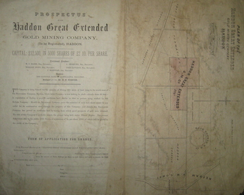
Plan and Prospectus, Plan and Prospectus of the Haddon Great Extended Gold Mining Company
The Haddon Great Extended GMC was formed sometime in the 1870s for the purpose of mining 270 acres of land lying to the south-west of the Racecourse Company (who at that stage had a shaft at the depth of 86 feet)A printed piece of paper with a prospectus on the left and a plan on the right. The plan includes a shaded area representing the Haddon Great GMC, and shows neighbouring companies such as Racecourse GMC, Haddon Consols, Reform GMC, Haddon Co, and also shows Russel's Private Propert and Roach's Private Company, and the Trap-Rock Formation.haddon great extended gmc, wc elder, william levey, c thorburn, john langdon, hb forster, national bank of australasia, haddon, racecourse company, h.b. forster, w.c. elder, john langdon, william levey, c. thorburn, john langdon, shares, racecourse goldmining company, reform gold mining company, haddon consols, haddon great extended gold mining company, russell