Showing 5442 items
matching level
-
 Kew Historical Society Inc
Photograph, Floods in North Kew, 1934
Living with natural processes was frequently a challenge to early European settlers and later residents of what was in the 1850s administered by the Borondara Road Board. This was compounded by the area being bounded on three sides by rivers (Yarra River, Koonung Creek and Gardiner's Creek). In 1849, the historian James Bonwick recorded that "our district [Kew] suffered considerably. Mr Wade speaks of 80 acres, out of 100 acres of his cultivated paddock, covered by water." Newspapers continued to describe major flooding in Kew in 1863, 1869, 1878, 1880, 1889, 1891, 1916 and 1934. While the construction of the Upper Yarra dam in 1957 reduced the levels of flowing downstream, local and riverine floods continue.The Kew Historical Society's pictures and map collections testify to the impact of flooding in the district. They have historical importance in documenting the extent of flooding in the district and its affects on homes, services and recreation. Numerous photographs record flooding throughout the Twentieth Century.Floods in North Kew, 1934. Vicinity of Willsmere Park.floods (kew) -
![Flooding at Chipperfield's Boathouse [East Kew], 1934](/media/collectors/550653872162f11fb04854aa/items/58cbaad5d0cec425b474bfb1/item-media/58cf6fbdd0cf9f331490feb0/item-fit-380x285.jpg) Kew Historical Society Inc
Kew Historical Society IncPhotograph, Flooding at Chipperfield's Boathouse, 1934
Living with natural processes was frequently a challenge to early European settlers and later residents of what was in the 1850s administered by the Borondara Road Board. This was compounded by the area being bounded on three sides by rivers (Yarra River, Koonung Creek and Gardiner's Creek). In 1849, the historian James Bonwick recorded that "our district [Kew] suffered considerably. Mr Wade speaks of 80 acres, out of 100 acres of his cultivated paddock, covered by water." Newspapers continued to describe major flooding in Kew in 1863, 1869, 1878, 1880, 1889, 1891, 1916 and 1934. While the construction of the Upper Yarra dam in 1957 reduced the levels of flowing downstream, local and riverine floods continue.The Kew Historical Society's pictures and map collections testify to the impact of flooding in the district. They have historical importance in documenting the extent of flooding in the district and its affects on homes, services and recreation. Numerous photographs record flooding throughout the Twentieth Century.Floods in North Kew, 1934. Chipperfield's Boathouse and the adding Moorings was located beside the Yarra River near the corner of Willsmere and Kilby Roads. The flood reached the roof of the Moorings, which can be seen in the photo.floods (kew), floods (kew) 1934, yarra river -
 Kew Historical Society Inc
Photograph, Floods in North Kew, 1934
Living with natural processes was frequently a challenge to early European settlers and later residents of what was in the 1850s administered by the Borondara Road Board. This was compounded by the area being bounded on three sides by rivers (Yarra River, Koonung Creek and Gardiner's Creek). In 1849, the historian James Bonwick recorded that "our district [Kew] suffered considerably. Mr Wade speaks of 80 acres, out of 100 acres of his cultivated paddock, covered by water." Newspapers continued to describe major flooding in Kew in 1863, 1869, 1878, 1880, 1889, 1891, 1916 and 1934. While the construction of the Upper Yarra dam in 1957 reduced the levels of flowing downstream, local and riverine floods continue.The Kew Historical Society's pictures and map collections testify to the impact of flooding in the district. They have historical importance in documenting the extent of flooding in the district and its affects on homes, services and recreation. Numerous photographs record flooding throughout the Twentieth Century.Floods in North Kew, 1934. Unidentified location on the Yarra Flood Plain at Kew.floods (kew) 1934, yarra river -
 Kew Historical Society Inc
Photograph, Floods in North Kew, 1934
Living with natural processes was frequently a challenge to early European settlers and later residents of what was in the 1850s administered by the Borondara Road Board. This was compounded by the area being bounded on three sides by rivers (Yarra River, Koonung Creek and Gardiner's Creek). In 1849, the historian James Bonwick recorded that "our district [Kew] suffered considerably. Mr Wade speaks of 80 acres, out of 100 acres of his cultivated paddock, covered by water." Newspapers continued to describe major flooding in Kew in 1863, 1869, 1878, 1880, 1889, 1891, 1916 and 1934. While the construction of the Upper Yarra dam in 1957 reduced the levels of flowing downstream, local and riverine floods continue.The Kew Historical Society's pictures and map collections testify to the impact of flooding in the district. They have historical importance in documenting the extent of flooding in the district and its affects on homes, services and recreation. Numerous photographs record flooding throughout the Twentieth Century.Floods in North Kew, 1934. Chipperfield's Boat House under flood.floods (kew) 1934, yarra river, chipperfield's boat house -
 Kew Historical Society Inc
Photograph, Floods in North Kew, 1934
Living with natural processes was frequently a challenge to early European settlers and later residents of what was in the 1850s administered by the Borondara Road Board. This was compounded by the area being bounded on three sides by rivers (Yarra River, Koonung Creek and Gardiner's Creek). In 1849, the historian James Bonwick recorded that "our district [Kew] suffered considerably. Mr Wade speaks of 80 acres, out of 100 acres of his cultivated paddock, covered by water." Newspapers continued to describe major flooding in Kew in 1863, 1869, 1878, 1880, 1889, 1891, 1916 and 1934. While the construction of the Upper Yarra dam in 1957 reduced the levels of flowing downstream, local and riverine floods continue.The Kew Historical Society's pictures and map collections testify to the impact of flooding in the district. They have historical importance in documenting the extent of flooding in the district and its affects on homes, services and recreation. Numerous photographs record flooding throughout the Twentieth Century.Floods in North Kew, 1934. Flood near the lagoon (Billabong?)floods (kew) 1934, yarra river -
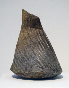 Federation University Art Collection
Ceramic - Artwork - Ceramics, Peter Pilven, "A Raided Form IV" by Peter Pilven, 2006, 2006
Peter PILVEN (1956- ) Born Ballarat Peter Pilven is acknowledged by his peers for his high level of tacit skills, including throwing, and for his sound technical knowledge of materials.Training with John Gilbert's Edinborough Pottery from 1972-1975, Pilven trained with Joan Campbell in Fremantle in 1976. In 1977 Peter Pilven obtained a Diploma of Fine Art (Ceramics) from Ballarat College of Advanced Education (now Federation University). The following year he worked with Ian Dowling at Geraldton, WA, and with the Western Australian Aboriginal Education Unit in 1979. He next trained with Alan Cagier-Smith in England between 1980 and 1981. Peter Pilven established his own studion in 1982.Hand built anagama [woodfired] stoneware. This work is part of the Jan Feder Memorial Ceramics Collection. Jan Feder was an alumna of the Gippsland Campus who studied ceramics on the campus. She passed away in the mid 1980s. Her student peers raised funds to buy ceramic works in her memory. They bought works from visiting lecturers who became leading ceramic artists around the world, as well as from many of the staff who taught there.ceramics, artwork, artists, jan feder memorial ceramics collection, peter pilven, churchill, alumni -
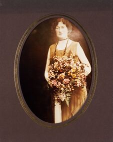 City of Greater Bendigo - Civic Collection
Photograph - Portrait, Vincent Kelly, Ethel Garvin, Mayoress 1931 - 32 , 1938 - 39, unknown
Prior to the election of female Councillors and Mayors in the 1960’s, the Lady Mayoress role was one of the few ways women could officially undertake civic duties. Mayoresses made important contributions to their local communities through their charity work and as ambassadors for their region on a state and federal level. They also undertook some Mayoral duties on occasions when their husband was unavailable. Ethel Rose Douglas married George Dawson Garvin in 1906 and was twice Mayoress from 1931 - 32 and 1938 - 39. Mayoress Ethel Garvin died in 1952 aged 74 and had been an esteemed member of the Women's Central Auxiliary of the Bendigo Base Hospital, a member of the Baby Health Centre and Mayoral Ladies Auxiliary. Reproduction of photographic studio portrait sitting behind oval mount.vincent kelly, studio photography, raymond kelly, city of bendigo mayoress, city of greater bendigo portraits, mayoress garvin, mayor garvin, ethel douglas -
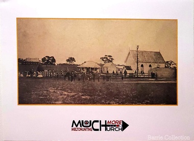 Melton City Libraries
Archive, Melton Uniting Church Dinner invite, 2017
"The Uniting Church and former church hall are historically significant at a Local level (AHC A4). It was built after Melton’s ‘United’ church and school, erected by Protestant denominations in 1857 in an effort to share resources in the pioneering era, was replaced by individual churches in the 1860s. The church became the home of and is expressive of the union of the Methodist and Presbyterian churches, begun in Melton from the early 1970s, and formally concluded by the formation of the Uniting Church of Australia in 1977. The new additions and functions of the church are expressive of the increase in Melton’s population especially in the 1970s, and the changing nature of the parish’s ministry. The church is one of only three remaining nineteenth century churches, and one of only two remaining bluestone churches, in the Shire of Melton".Dinner celebrating 150 years of the churchchurches -
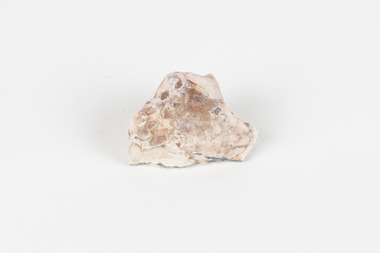 The Beechworth Burke Museum
Geological specimen - Opal Bearing Stone, Unknown
There are 17 opal fields in Australia. This opal bearing stone was found in Lightning Ridge, NSW over what is known as the Great Australian Basin. This basin was formed and covers an area of 1.7 million square kilometers in eastern Australia in the Cretaceous period. This basin used to contain an inland sea, which provided an environment where silcrete eventually formed when water levels changed. This eventually seeped into other structures, and eventually hardened and formed opal. Lightning Ridge has a population of around 2000 people, with about 80 000 visitors every year. It is a historic mining town, and is known for its deposits of a rare black opal. Mining started in the area in the late 1800s, early 1900s when the black opal was discovered. This opal-bearing stone is of social and historical significance. It is from Lightning Ridge, which is well-known for being a large producer of opal stones, most famously black opal. The history of the period dates back to 140 million years, with the discovery of black opal in the early 1900s causing interest in the area. This specimen is part of a larger collection of geological and mineral specimens collected from around Australia (and some parts of the world) and donated to the Burke Museum between 1868-1880. A large percentage of these specimens were collected in Victoria as part of the Geological Survey of Victoria that begun in 1852 (in response to the Gold Rush) to study and map the geology of Victoria. Collecting geological specimens was an important part of mapping and understanding the scientific makeup of the earth. Many of these specimens were sent to research and collecting organisations across Australia, including the Burke Museum, to educate and encourage further study.***A palm-sized solid mineral specimen in shades of beige and light orange*** silica based? burke museum, beechworth, geological, geological specimen, opal, opal fields, australia, lightning ridge, new south wales, great australian basin, cretaceous, silcrete, black opal, mining -
 Warrnambool and District Historical Society Inc.
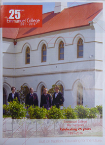
Booklet, Emmanuel College Warrnambool: celebrating 25 years 1991-2016, 2016
Emmanuel College is the result of the amalgamation of St Ann's girls' college and Christian Brothers' College boys' school in 1991. Mother Philomene Maguire arrived in Warrnambool and commenced a Convent of Mercy and school with the consent of the then Bishop of Victoria, Bishop Goold. The school opened in Wyton House in Botanic Road. Brother Egan arrived in 1902 and set up a Brothers' group and school and 104 boys enrolled. Since its inception in 1991 Emmanuel College provides a broad education for students to Year 12 level. A number of students have achieved a high profile in the community, including footballer Jonathan Brown, television personality Dave Hughes, educatior Professor Colin Ferguson, musician Shane Howard, Olympic cyclist Michelle Ferris.This booklet briefly documents the history of Emmanuel College and its predecessors St Ann's and CBC and includes a list of their more prominent and well-known 'inspiring alumni'. It provides research information and window on a period of socialA4 size full colour booklet with a photograph of a white building with light brown trim and red iron roof and arched windows; four senior students (two boys and two girls) wearing school uniform are standing in the foreground. Their blazers feature the school logo. Title is white print in a red box and a sub-title at the bottom right hand side is in red print. 15 pages25 YEARS/Emmanuel College/1991-2016 Emmanuel College/Warrnambool/Celebrating 25 years/1991-2016 Built on tradition, Educating for the future.emmanuel college, convent of mercy, bishop goold, catholic schools, wyton house, brother egan, st ann's college, christian brothers college warrnambool, education, education in the warrnambool area, boyce, rosalie, ferris, michelle, gorman, lisa, howard, shane, keilar, brendan, o'dwyer, dr barry, ryan, kathryn, brown, jonathan, atkinson, david oam, coghlan, gorgi, earls, judith, o'shea, br frank, ryan, dr kevin, houlihan, sr natalie, hughes, dave, ferguson, prof colin, howard, sr adele, ryan, shaun, smith, karan, lanigan, sgt sean, melican, felicity, turner, michael, green, danielle mp, holland, nicki, o'keefe, marcia oam, o'toole, melanie, harrington, clayton, gallagher, br don, gleeson, dr laurence, gleeson, trevor, houlihan, patrick, mugavin, fr patrick -
 Eltham District Historical Society Inc
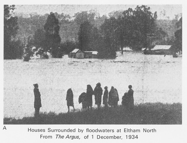
Work on paper (Sub-Item) - Photograph, Houses surrounded by floodwaters at Eltham North
"The house (centre) at North Eltham in which Mr. and Mrs. William Frizell, an elderly couple, were marooned by flood waters. When this photograph was taken late yesterday afternoon the couple were still inside the house, and through a ventilator they had stuck a red flag which they waved from time to time. The house on the left belongs to Mr. Leads, who also was marooned." - The Argus 1 December 1934. John William Frizell, painter and his wife Sarah Jane are registered at Glen Park, Eltham in the 1924 Electorial Roll This was most probably the Diamond Creek in flood. In 1934 extensive flooding of the Yarra River and Diamond Creek sets new records for flood plain level (via Chronology of Eltham, EDHS) flood, frizell, leads, argus, glen park, eltham north, flooding, marooned, diamond creek -
 Kiewa Valley Historical Society
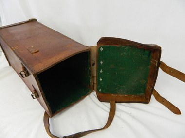
Case Volt Meter Recorder, Circa 1950 to 1977
This case is for a testing voltmeter recorder. The last time it was certified by SEC Vic laboratories on the 17/4/77. It was used extensively in the transportation of the mobile recorder which was sometimes placed for periods of one month at locations experiencing unacceptable fluctuations of power. These locations would cover the North East regions of Victoria. They cover voltage drops at domestic and business properties especially those that were experiencing regular fluctuations(daily) at approximately the same time of the day. As the electrical network is required to operate within a set level of voltage, fluctuations outside of this has to be investigated and necessary remedial action taken. This is especially so for rural properties where power "drainage" can occur through animal/bird and tree interference. See KVHS 0302 (A) for the instrument.This case for a mobile voltage recorder is very significant to the Kiewa Valley because it highlights the difficulties that can occur in maintaining a power supply that experiences fluctuating power demands by the rural industries that it supplies. The requirement of a mobile testing apparatus to cover the various sections in the Kiewa Valley and other rural areas in the northeast region is one of necessity as electricity once connected to a rural property is a labour saving supply as generators on rural properties require a higher degree of maintenance an ultimately at a higher cost. The testing of the SEC Vic supplied electricity to rural properties,those who had previously run on generators, had to be quick and unassuming with certainty of correct supply levels.This heavy and thick all leather case for the "easy" transportation of the Volt meter recorder has a opening top which pop riveted to the main body(rivets are aluminium). The all leather top has a shaped carrying handle which is also riveted on. There are two straps on the side of the top which can be fastened to the main body by metal "shoe" buckles. The bottom end is secured to the main bag by large rivets.Tick grade stitching is on all corners.Nilsec vic kiewa hydro scheme, alternate energy supplies, alpine growth in electricity consumption -
 Warrnambool and District Historical Society Inc.
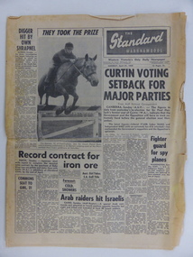
Document Newspaper, The Standard 1969, Monday 21st April 1969
This paper records local, national and International news with events such as elections news, sports news, and 807 entries for the Warrnambool May Races.Other local articles relate to curriculum at Warrnambool High School,Port Fairy Sea Scouts as well as football results for many local teams of all levels. There are also photographs of Junior tennis A grade champions. Likewise there are many advertisements for local businesses such as Swintons Rock A bye Cradle shop and Stephens Stores. The film The graduate was playing at the Capitol Theatre and still drawing large crowds The Warrnambool Standard was established in 1872 and had remained locally owned until taken over by the Melbourne Age in 1980. Both were subsequently taken over by Fairfax media in 1983As the only daily local newspaper in the Western District,The Warrnambool Standard contains much that is of interest socially and historically. Black text with photograph of young boy on horseback ,jumping fence. back page has articles about sport with photograph of three footballers contesting for the ball. 12 PagesThe Warrnambool Standard Monday April 21 1969.warrnambool, warrnambool standard, standard 1969, -
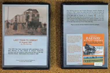 Orbost & District Historical Society
D.V.D. s, Last Train to Orbost, 21.8.1987
These are copies of an original video shot by Ray Barling on the day that the Orbost-Bairnsdale line closed in 1987. He used a hand-held video camera from his cabin on the train, The video was shown at the 2016 Centenary Exhibition in Orbost. The Bairnsdale-Orbost railway was opened in 1916 to serve the agricultural and timber industry. Because of the decline in traffic and heavy operating costs, the line was finally closed in August, 1987. Orbost Railway Station was opened on Monday 10 April 1916 as the terminus of the Orbost railway line, and closed in 1987. The station was located on the west side of the Snowy River despite the town of Orbost being on the east side of the river, in order to save on the costs of a bridge over the river, which at the time had highly variable levels. This item is associated with the history of the Orbost-Bairnsdale railway line and therefore reflects the role that the rail line played in the social and economic history of Orbost. On April 10 1916, the first scheduled train service left Orbost for Bairnsdale. The Bairnsdale-Orbost railway was opened to serve the agricultural and timber industry. Because of the decline in traffic and heavy operating costs, the line was finally closed in August, 1987. Orbost Railway Station was opened on Monday 10 April 1916 as the terminus of the Orbost railway line, and closed in 1987. The station was located on the west side of the Snowy River despite the town of Orbost being on the east side of the river, in order to save on the costs of a bridge over the river, which at the time had highly variable levels, The video was shown for the first time at the Centenary Exhibition held in Orbost, by the Orbost & District Historical Society, t created much interest leading to the production of the videos.Two copies of a D.V.D. titled"Last Train To Orbost 21 August 1987". The cover is a photo of the last train.rail-closure orbost-bairnsdale-railway -
 Churchill Island Heritage Farm
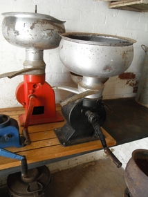
Functional object - Milk/cream separator
This device would separate the cream from milk using a hand operated lever. When turned, the lever would activate a disc which would spin the separator bowl at a great speed. Through this use of centrifugal force, the cream would gather in the middle while the milk would be pulled towards the outside walls of the bowl. Once the rotation ceased, the milk and cream would flow out of two separate spouts. Prior to the invention of the separator, gravity was used to naturally separate the cream from the milk. The cream rose to the top and was then skimmed by hand. This process was lengthy and often resulted in sour milk, so the invention of the mechanical separator was popular in the dairy industry as there was less waste and encouraged greater production levels. Silver bowl with black base with handle; mounted on boardfarm, machinery, dairy, equipment, milk, cream, separator, hand operated, churchill island -
 Whitehorse Historical Society Inc.
Photograph, Schwerkolt Cottage, 1962
Photo sent to Mary Jack, Pittsburgh USA by Charles Schwerkolt. Accompanying text sent by Charles - 'This is the end facing Deep Creek Road. You will notice the wood boards are all curved. The floor is all eaten away with white ants and is all levels and the weatherboards have fallen at the ends. The roof is very bad also the gable of the stone looks not so good. The wooden kitchen is about 6 inches away from the stone house all the way around. You will notice the roof of the stone house is all colours with rust and paint. You will notice there are no spouts to take the water away. I took another photo but the light got into the lens of my camera so they would not print a photo from it.Black and white photo of Schwerkolt Cottage. The condition of the Kitchen roof is visible. The floor was ant eaten and a 6"' gap separated the Kitchen from the Cottage. Thin Black Border.schwerkolt cottage, schwerkolt, charles clarence victor, whalen, rosalie, jackschowsky, mary elizabeth -
 Ballarat Heritage Services
Photograph - Colour, Central Highlands Historical Association Expo, c 1996
Central Highlands Historical Association [CHHA] is a vital link in the regional history network being the umbrella association for over 30 historical societies, museums and family history organisations in the central highlands region of Victoria. CHHA continues to be an active and innovative organisation. It is represented at Local and State levels on matters of joint concern to its members. Aims and Purposes: Formed in 1984 the inaugural CHHA meeting was held on Saturday 23 June 1984, at the Ballarat City Library in Camp Street, Ballarat. A main focus of CHHA is to assist its member societies by developing and maintaining resources and information networks. To promote history and heritage in the region To encourage the preservation and conservation of heritage To promote and encourage easier public access to records through local museums and societies 6 coloured photographs postcard sizenonechha, central highlands historical association, dorothy wickham, clare gervasoni, raymond shuey -
 Moorabbin Air Museum
Machine - Avro Lincoln RF392 (G-Aprj "G-29-1"), 1945
Historical Details: AVRO LINCOLN B.2 G-APRJ/RF342 DELIVERED TO RAF FROM AVRO 6-1945. RAF 6-1945 to 7-1948 at TFU. AWA LTD/EMI LTD LOAN FROM RAF 7-1948/7-1955 D NAPIER & SONS LTD LOAN FROM RAF 7-1955 / 12-1958 SOLD TO D NAPIER & SONS LTD LUTON 12-1958; SOLD TO COLLEG. Description: The Avro Lincoln bomber was the successor to the famous Avro 683 Lancaster of World War 2 . In the immediate post war era the Australian Government Aircraft Factory undertook the licenced manufacture of 73 Lincolns for the RAAF the first of which flew. Level of Importance: Regional -
Moorabbin Air Museum
Archive (Item) - Box BDA6C Boeing (Gaf / Asta) Collection
Description: Box BDA 6B - 4 folders - labelled: BOOK 14 NOMAD N22 SUPERSEDED LINE STAGE ALL N-000-130 to N-000-280 BOOK 26 FAB TRAVS N-82-686 to N-82-ON 1980.ON BOOK 26A FAB TRAVS N-84-21 to N-88-146 1980 ON BOOK 28 FAB TRAVS N-93-584 ON 1980 O Level of Importance: National. Historical Details: DAP/GAF/ASTA constructed many overseas designs under licence in Australia (Beaufort, Beaufighter, Lincoln, Canberra and F18) however they also designed and constructed a number of significant local designs that were successful in oversea's markets includi -
Vision Australia
Object, David Palmer plaque, 1960
Plaque commemorating D.L. Palmer, Musician to the Blind, 1882-1955. David Palmer was a music teacher and Director of Music at the Royal Victorian Institute for the Blind (R.V.I.B.) for over 40 years and conducted the R.V.I.B. choir and orchestra. The orchestra had about twenty musicians, all of whom were vision impaired, and was popular with the public for dances and events. Mr Palmer and the other music teachers would transcribe over a thousand sheets of music every year for the orchestra into Braille. This copper plaque is mounted on a wooden block, dedicated to D.L. Palmer, 1882-1955, Musician to the Blind. The design features a head in profile with raised wavy lines running across at eye and ear level. Above the head is the inscription repeated in Braille. 1 wooden block with copper plaque -
 Ballarat Diocesan Historical Commission
Magazine, Bungaree YCW Magazine, 1953
Rev. Dr Delaney advocated for the formation of the Ballarat CYMS. Curtin and Scullin being members and learning their debating skills there. The Diocese of Ballarat advocated the development of the Young Christian Workers', YCW, over the CYMS from the 1940's onward as there was a stronger spiritual development base. While there are earlier examples, this is one example of a parish based youth magazine from the organisation in the diocese of Ballarat. Prominent in this YCW group was former Victorian politician Frank Sheehan and local Shire President John Parkin. Bungaree parish had very active parish youth organisations with published journals dating back to the 1930s. Initiallyl producing CYMS magazines at a parish level this had transferred to the YCW by the 1950s and this was the first YCW issue.The Ballarat Catholic Young Men's Society, CYMS was established in1892 and catered for Catholic youth. ycw, bungaree parish, youth group, curtin, scullin, sheehan, parkin. -
 Glen Eira Historical Society
Album - Album page, Glenferrie Street, 4, Circa 1972
This photograph is part of the Caulfield Historical Album 1972. This album was created in approximately 1972 as part of a project by the Caulfield Historical Society to assist in identifying buildings worthy of preservation. The album is related to a Survey the Caulfield Historical Society developed in collaboration with the National Trust of Australia (Victoria) and Caulfield City Council to identify historic buildings within the City of Caulfield that warranted the protection of a National Trust Classification. Principal photographer thought to be Trevor Hart, member of Caulfield Historical Society. Most photographs were taken between 1966-1972 with a small number of photographs being older and from unknown sources. All photographs are black and white except where stated, with 386 photographs over 198 pages. From Glen Eira Heritage Management Plan 1996 by Andrew Ward: In 1905, most of portion 27 was vacant land, however Glenferrie Street had been formed and the land subsequently subdivided. In 1906, Robert Joseph Haddon, architect and painter, designed and built for his private residence, a brick house on the west side. Haddon named the house "Anselm". Also built on the property were a garage and fibro cement studio. "Anselm" is architecturally important at the State level as a substantially intact, highly personalised and boldly expressed house expressive the Arts and Crafts movement and incorporating Art Nouveaux enrichment in a variety of forms, the use of ornamental terra cotta tiles to the comer tower being of special note. Its importance at the State level is strengthened by its place as the home of the noted architect and Melbourne's most influential exponent (Freeland, J.M., Architecture in Australia, p. 213) of the Art Nouveaux movement.https://vhd.heritagecouncil.vic.gov.au/places/4442 Victorian Heritage Register: What is significant? Anselm was designed by noted English born architect Robert Joseph Haddon(1866-1929) as his own house and constructed in 1906. A single storey Arts and Crafts influenced red brick house with attic, Anselm has a pyramidal slate roof with prominent chimney stacks. There is a octagonal corner tower with saucer shaped domed roof surmounted by a weather vane, and the tower has decorative terracotta panels immediately below the eaves line. The front door opens immediately into a large living or common room, screened from view by a timber and bottle glass screen. The large room was designed to function as a drawing and dining room. The house is rich with hand crafted details including door and window furniture, wrought iron gutter brackets, fireplaces (one with built in wood box), and fire tools. The interior decoration includes hand painted frieze of Port Phillip in the study, and a hand painted frieze of turbulent sea with sailing boats in the tiled bathroom. There is a small hand painted tile at the base of the tower which states ?This building was erected AD1906 from designs by Robt J Haddon FRIBA,Lond FRIVA Melb Architect?. He also designed an attic addition which was constructed in 1927. Anselm is substantially intact although the double casement window immediately to the south of the front door was originally circular....Page 60 of Photograph Album with three exterior photographs (one portrait and two landscape) of Anselm.Hand written: 4 Glenferrie Street [top right] / ANSELM 4 Glenferrie St [under top photo] / 60 [bottom right] trevor hart, anselm, art nouveaux, arts and crafts, tower, bay window, glenferrie street, robert joseph haddon, 1900's, terra cotta tiles, double storey, caulfield north, corner tower, gates, cast iron work -
 Glen Eira Historical Society
Album - Album page, Glenferrie Street, 4, Circa 1972
This photograph is part of the Caulfield Historical Album 1972. This album was created in approximately 1972 as part of a project by the Caulfield Historical Society to assist in identifying buildings worthy of preservation. The album is related to a Survey the Caulfield Historical Society developed in collaboration with the National Trust of Australia (Victoria) and Caulfield City Council to identify historic buildings within the City of Caulfield that warranted the protection of a National Trust Classification. Principal photographer thought to be Trevor Hart, member of Caulfield Historical Society. Most photographs were taken between 1966-1972 with a small number of photographs being older and from unknown sources. All photographs are black and white except where stated, with 386 photographs over 198 pages. From Glen Eira Heritage Management Plan 1996 by Andrew Ward: In 1905, most of portion 27 was vacant land, however Glenferrie Street had been formed and the land subsequently subdivided. In 1906, Robert Joseph Haddon, architect and painter, designed and built for his private residence, a brick house on the west side. Haddon named the house "Anselm". Also built on the property were a garage and fibro cement studio. "Anselm" is architecturally important at the State level as a substantially intact, highly personalised and boldly expressed house expressive the Arts and Crafts movement and incorporating Art Nouveaux enrichment in a variety of forms, the use of ornamental terra cotta tiles to the comer tower being of special note. Its importance at the State level is strengthened by its place as the home of the noted architect and Melboume's most influential exponent (Freeland, J.M., Architecture in Australia, p. 213) of the Art Nouveaux movement. Victorian Heritage Register https://vhd.heritagecouncil.vic.gov.au/places/4442 What is significant? Anselm was designed by noted English born architect Robert Joseph Haddon(1866-1929) as his own house and constructed in 1906. A single storey Arts and Crafts influenced red brick house with attic, Anselm has a pyramidal slate roof with prominent chimney stacks. There is a octagonal corner tower with saucer shaped domed roof surmounted by a weather vane, and the tower has decorative terracotta panels immediately below the eaves line. The front door opens immediately into a large living or common room, screened from view by a timber and bottle glass screen. The large room was designed to function as a drawing and dining room. The house is rich with hand crafted details including door and window furniture, wrought iron gutter brackets, fireplaces (one with built in wood box), and fire tools. The interior decoration includes hand painted frieze of Port Phillip in the study, and a hand painted frieze of turbulent sea with sailing boats in the tiled bathroom. There is a small hand painted tile at the base of the tower which states ?This building was erected AD1906 from designs by Robt J Haddon FRIBA,Lond FRIVA Melb Architect?. He also designed an attic addition which was constructed in 1927. Anselm is substantially intact although the double casement window immediately to the south of the front door was originally circular....Page 61 of Photograph Album with one exterior photograph (portrait) of Anselm.Hand written: 61 [bottom left] trevor hart, anselm, art nouveaux, arts and crafts, tower, bay window, glenferrie street, robert joseph haddon, 1900's, terra cotta tiles, double storey, caulfield north, corner tower, brick house, attics -
 Bendigo Historical Society Inc.
Document - ALBERT RICHARDSON COLLECTION: HERCULES MINE REPORT 1936
a. four page handwritten report on the Hercules Mine, half yearly reports 1936. Extract: Reef worked below the 1620 feet level has been opened up at 1,840 feet. Profit has been earned but values are now unprofitable. At the Stanfield shaft, erection of plan was completed and shaft sunk to 344 feet. X cuts put out at 230 and 310 feet. Angus Mackay Chairman. b. Summary of sale of mine from Bendigo Advertiser 19.6.1950, handwritten by Albert Richardson, re the sale of the mining equipment at the Hercules Mine. ' Winding engines sold for £200 Compressor £425 and the oregon poppet legs for £41. The three main buildings went for £435 , the office and store room for £80, and die room for £12 Most spirited bidding was for 5 tons of firewood which finally went for £12Albert Richardsonbendigo, mining, hercules mine -
Bendigo Historical Society Inc.
Map - HUSTLER'S ROYAL RESERVE NO 2 CO. - LONGITUDINAL SECTION OF THE HUSTLER'S ROYAL RESERVE NO 2 CO
Longitudinal Section of the Hustler's Royal Reserve No 2 Co. on the Hustler's Line of Reef Bulletin No 33, Plate No VIII. Note - Plates 4, 8, 13, 20, 26 & 31 form a Longutudinal Section from Fortuna Hustler's to Hustler's Consols Mine. Mines mentioned are the Hustler's Royal Reserve No 2 Main Shaft, Hustler's Royal Reserve No 2 Park Shaft, Royal Hustler's, Imperial Hustler's, Great Extended Hustler's Freehold and the Great Extended. Section shows depth of levels, datum lines and height of sill above sea levelyield in ozs od gold. Geological Survey of Victoria emblem. H. Herman, Director, W. Dickson, Secretary for Mines and The Hon. J. Drysdale Brown MLC, Minister for Mines and signed by H S Whitelaw, Underground Survey Office Bendigo, September 1913. This item has not been scanned or photographed.mining, parish map, hustler's royal reserve no 2, longitudinal section of the hustler's royal reserve no 2 co, hustler's royal reserve no 2 (main shaft), hustler's royal reserve no 2 (park shaft), royal hustler's, imperial hustler's, great extended hustler's freehold, great extended, geological survey of victoria, underground survey office bendigo, h s whitelaw, h herman, w dickson, the hon j drysdale brown -
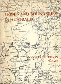 Victorian Aboriginal Corporation for Languages
Book, Nicolas Peterson, Tribes and boundaries in Australia, 1976
Some ecological bases for Australian tribal boundaries /? Norman B. Tindale Man and ecology in the highlands of southeastern Australia : a case study /? Josephine Flood The natural and cultural areas of Aboriginal Australia : a preliminary analysis of population groupings with adaptive significance /? Nicolas Peterson 'The chain of connection' : the material evidence /? D.J. Mulvaney Realities and transformations : the tribes of the Western Desert of Australia /? Joseph B. Birdsell Structure, event and ecology in Aboriginal Australia : a comparative viewpoint /? Aram A. Yengoyan Territoriality and the problem of demarcating sociocultural space /? Ronald M. Berndt Communication and change in mythology /? Kenneth Maddock Levels of organisation and communication in Aboriginal Australia /? D.H. Turner Boundaries and kinship systems in Aboriginal Australia /? F.G.G. Rose Tribes, languages and other boundaries in northeast Queensland /? R.M.W. Dixon Aboriginal language distribution in the Northern Territory /? E.P. Milliken.maps, b&w photographs, diagramsecology, environment, sociology, kinship systems, language distribution -
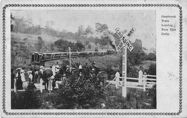 Southern Sherbrooke Historical Society Inc.
Postcard - Gembrook Train Leaving Fern Tree Gully
B&W postcard, 'Gembrook Train Leaving Fern Tree Gully'. The postcard has a photo of a level crossing at Ferntree Gully. The down train has just cleared the crossing and a large group have either just crossed the line or are about to. One woman is carrying an umbrella. A horse-drawn carriage is in the process of crossing the track, obscured by a large shrub. There is a warning sign at the crossing saying 'Railway Crossing, Look out for trains'. Behind the train is a hill with scattered trees. The photo has a patterned, printed frame around it. On the back of the postcard is a written message. 'Am sending ad/vanced birthday/ cards to the/ little girls with/ love. Had a letter from Addie last/ week. A.S. Hunt' and in the address panel, 'Mrs W. Upton/ Wyndham/ Werribee.' A postage stamp has been removed from the card, obscuring the date stamp. -
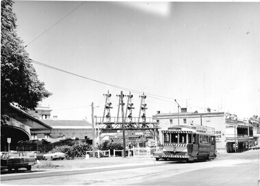 Ballarat Tramway Museum
Photograph - Black & White Photograph/s - set of 6, Charles Craig, 1950s
Yields information about the appearance and use of the Ballarat Railway Station level crossing by trams prior to closure.Set of six black and white photographs of trams at the railway level crossing, Ballarat, Lydiard St North featuring the railway station, gates and signals, Reeds Coffee Palace and the Provincial Hotel. .1 - 28 heading south, with an R class and a K class locomotive in the view. .2 - 11, heading north - taken during the 1950's. .3 - 17 parked right up to the gates while K184 shunts at the station. .4 - single trucker (number obscured) - most likely 17 giving the passengers in the previous photo. .5 - Photo with two single truckers in the view and the gates being closed after the tram has passed. .6 - 11, at the gates with a bogie tram behind. No. 11 has a Briquettes roof advert and a Twin Lakes sign. Photo by Charles Craig - during 1971, except for .2, taken during the 1950's. trams, tramways, lydiard st north, railway station, signals, level crossings, tram 28, tram 11, tram 17 -
 Ballarat Tramway Museum
Document - Form/s, Australian Railway Historical Society (ARHS), "Farewell to the Ballarat Trams", Jul. 1971
Folded foolscap sheet - white paper - offset printed both sides, tour brochure - titled "Farewell to the Ballarat Trams". Rail tour brochure published jointly by the ARHS and TMSV gives details of the proposed tour, timetable, fares, tram hire, how to book and tour organisers and on the rear conditions of travel. On the front has a photo of 28 crossing Lydiard St North level crossing with an R and J class steam locomotives in the background and ESCo. No. 5, with the ARHS and TMSV logos. Printed by Kamera Press. .2 - tour circular duplicated yellow paper, for the tour of 21/8/1971 - giving tour arrangements, photo stops, tram tour, tram mail, and next tour dates. Contains a tear off slip for the last tram mail - see Reg Item 2942. Item added 19/10/2017.trams, tramways, arhs, tmsv, pamphlets, closure, tours -
 Ballarat Tramway Museum
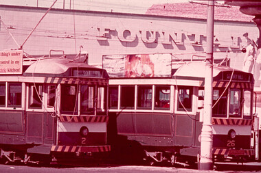
Slide - 35mm slide/s, Bob Wilson, May. 1972
White cardboard mount, 35mm slide, from the Association of Railway Enthusiast's film strip titled "Provincial Tramway Film Strip" of Bendigo bogie tramcars Nos. 2 and 26 at Charing Cross, with the Fountain Plaza building in the background. Both trams have the destination of "Quarry Hill" No. 26 has the older type of destination roll and is fitted with a SEC Briquettes roof advertisement. The film strip notes (Reg. Item 2560), provided the following caption details: "The hub of the Bendigo system was at Charing Cross, where the "Quarry HILL" - "EAGLEHAWK "and "'GOLDEN SQUARE" - "NORTH BENDIGO" routes crossed at right angles. It was customary for trams for all four routes to meet at the CROSS. Here cars 2 & 26 (showing a wrong dest- -ination) meet by the fountain. -Mar '72 (Bob Wilson)" See image btm2580p.tif for high level scan of image. Stamped on base of slide "11789" and written in ink on top edge "No. 2 & 26 Charing Cross Bendigo"tramways, trams, are, film strip, charing cross, bendigo, tram 2, tram 26