Showing 123968 items matching "main-road"
-
 Eltham District Historical Society Inc
Photograph, Liz Pidgeon, Heritage Excursion; Eltham Lower Park Walk and Talk, 1 July 2017, 1 July 2017
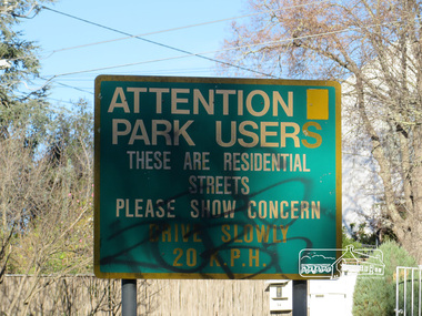
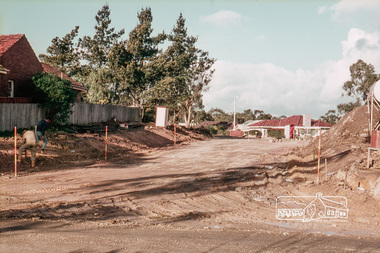
Street signage: Attention park users these are residential streets please show concern drive slowly 20 m.p.h with graffiti Newsletter No., 234, June 2017 Heritage Excursion - Saturday 1st July - Eltham Lower Park - Walk and Talk Eltham Lower Park has played an important part in the history of our area since the early days of European settlement when it was used by local residents as an informal racecourse. Prior to that its location at the junction of the Diamond Creek and the Yarra River made it an important meeting place for the Wurundjeri people. The park combines formal elements and sporting facilities with remnant bushland that is of environmental significance. It is home to sporting and horse riding clubs, popular play spaces and the Diamond Valley Miniature Railway, which attracts large numbers of visitors. The park will be the venue for our July excursion which will comprise a walk of about 3.5 km around the park and adjacent areas. Along the way we will discuss the history and natural history of the area. The path along the creek and the river provides a pleasant and scenic walk. This walk on Saturday 1st July is about 3.5 km in length and will take 2 to 2.5 hours. It will start at 2pm at the Main Road car park at the front of the park. (Melway ref 21 H 10). Born Digitalheritage excursion, activities, eltham district historical society, eltham lower park, sign, grafitti -
 Eltham District Historical Society Inc
Photograph, Liz Pidgeon, Heritage Excursion; Eltham Lower Park Walk and Talk, 1 July 2017, 1 July 2017
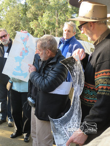
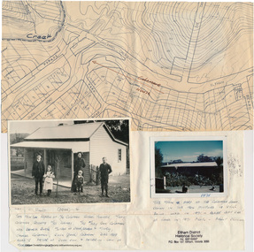
Local Historian Russell Yeoman and EDHS President Jim Connor with a map and aerial photograph of the area the heritage walk will cover. Newsletter No., 234, June 2017 Heritage Excursion - Saturday 1st July - Eltham Lower Park - Walk and Talk Eltham Lower Park has played an important part in the history of our area since the early days of European settlement when it was used by local residents as an informal racecourse. Prior to that its location at the junction of the Diamond Creek and the Yarra River made it an important meeting place for the Wurundjeri people. The park combines formal elements and sporting facilities with remnant bushland that is of environmental significance. It is home to sporting and horse riding clubs, popular play spaces and the Diamond Valley Miniature Railway, which attracts large numbers of visitors. The park will be the venue for our July excursion which will comprise a walk of about 3.5 km around the park and adjacent areas. Along the way we will discuss the history and natural history of the area. The path along the creek and the river provides a pleasant and scenic walk. This walk on Saturday 1st July is about 3.5 km in length and will take 2 to 2.5 hours. It will start at 2pm at the Main Road car park at the front of the park. (Melway ref 21 H 10). Born Digitalheritage excursion, activities, eltham district historical society, eltham lower park, russell yeoman, jim connor, guide -
 Ringwood and District Historical Society
Photograph, Looking from Werac Drive, North Ringwood, on 14th April 1978, across the site of the headwaters of Loughnan's Lake. Main body of water lay to the left (west)
E548 N7 Part of a 51-photo record of the development of the "Kubis" Estate, Ringwood North, including road works to Debbie Place, Kubis Drive, Werac Drive, Manuelo Drive, Iluka Place and Glenvale Road. From the Jack Lundy Clarke collection.51 -
 Greensborough Historical Society
Photograph - Photograph - Digital Image, Corner Grimshaw Street and Main Street Greensborough 1977, 1977_
A black and white photograph the corner of Grimshaw Street and Main Street Greensborough 1977, looking down Main Street. Note Coles New World on left.Digital copy of black and white photograph.grimshaw street greensborough, main street greensborough, coles new world greensborough -
 Stawell Historical Society Inc
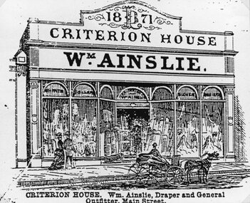
Drawing, Mr Wm. Ainslie, Criterion House in Main Street Stawell from the P.C. News Supplement 1888 -- Sketch
Wm. Ainslie Criterion House Main Street from P.C. News Supplement 1888 Building around 111 Main Street which was William the Shoeman stawell businesses -
 Lakes Entrance Historical Society
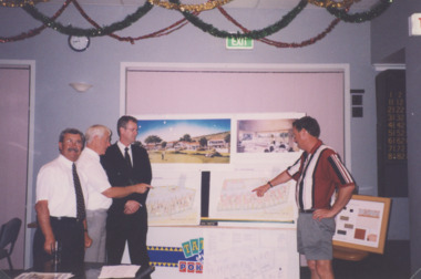
Photograph - Golf Houses residential development Golf Links Road Lakes Entrance Victoria, Lakes Post Newspaper, 1/12/1999 12:00:00 AM
Golf Houses residential development Golf Links Road Lakes Entrance Victoria - Proposed plan shown on notice boardColour photograph showing Matt Martino Bill Daniel Mike Hurst and Gary Jeal at the launch of Golf Houses residential development Golf Links Road Lakes Entrance Victoriatourism, land development -
 Greensborough Historical Society
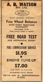
Advertisement - Digital image, Diamond Valley News, A. B. Watson, 21/11/1967
Advertisement in the local paper for A.B.Watson Pty Ltd of 108 Main Road Greensborough 1967Digital copy of newspaper advertisement.a.b.watson pty ltd, main street greensborough -
 Uniting Church Archives - Synod of Victoria
Photograph, Undated c.1880
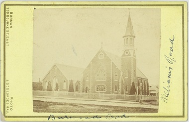
The Wesleyan Church was located at the corner of Burwood Road and William St. Hawthorn. It was designed by Messrs. Crouch and Wilson. The foundation stone was laid by the Hon. Alexander Fraser MLC on 14 August 1867. The Sunday School next to the church was built in 1878.Sepia carte de visite photograph of the Wesleyan Methodist Church located at the corner of Burwood Road and Williams Street Hawthorn.Burwood Road, Williams Roadwesleyan church, hawthorn, crouch and wilson, hon. alexander fraser -
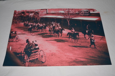 Wangaratta RSL Sub Branch
Photograph - Unframed Photograph, circa 1910
Image depicting Victorian Mounted Rifles parading behind Town Crier along Main Street WangarattaBlack white and dark pink photograph of soldiers on horseback being lead by Town Crier passing horse and buggies along main street.rear of photograph - 1910 Aust Light Horse, Main (Murphy) Street, Wangaratta preceded by Town Crier followed by City Bandlight horse troop, wangaratta, ww1, victorian mounted rifles, circa 1910 -
 Eltham District Historical Society Inc
Photograph, Jim Connor, Opportunity Shop, Eltham - Montmorency Uniting Church Hall, 810 Main Rd, Eltham, 7 May 2016
The Society conducted a heritage excursion "Eltham War Memorials Walk" on Saturday, May 7, 2016 in conjunction with the centenary commemorations of the First World War. This walk involved visiting a number of memorials along Main Road dedicated to locals who served Australia in times of war including the Roll of Honour located in the Uniting Church Hall which also serves as the Opportunity Shop, which had once operated out of the former CBA bank building next door.activities, eltham district historical society, heritage excursion, jim connor collection, opportunity shop, uniting church, uniting church hall, 2016-05-07 -
 Melbourne Tram Museum
Postcard, Traveller's Notes, Flinders St Station main entrance, Z81 (Route 67), and W6 981 (Route 1), 1995
Postcard - 3 panel full colour - by Traveller's Notes, of Flinders St Station main entrance, Z81 (Route 67), and W6 981 (Route 1). Divided back, published by Traveller's Notes, photos by Neil J Leed, 1995.trams, tramways, flinders st station, z class, w6 class, route 1, route 67, tram 81, tram 981 -
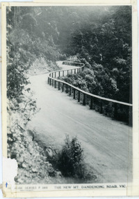 Mt Dandenong & District Historical Society Inc.
Photograph, The New Mt Dandenong Road, Vic
Copy of Rose Series postcard #385 showing the new Mt Dandenong Tourist Road with wooden railing fence on low side of road. Surface not yet made. This photograph has a detailed inscription on the back handwritten by John Lundy-Clarke in 1974.View downhill from the Windy Bend showing the site of the 1972 landslide. In this picture the road is running along the top edge of the wall 900’ thick of Kalorama Docite that plunges thousands of feet deep down into the earth below the Ranges and extends to Fern Tree Gully. It was once a horizontal terrace nearly ten miles square and tipped over to the left when the mountain subsided into its volcanic cauldron.mt dandenong road, rose series, windy bend, landslide -
 Eltham District Historical Society Inc
Slide, Construction of Apex Way between Looker Road and Grand Boulevard, Montmorency, 18 August 1970, 1970
The Eltham Apex Club conducted a Community Service Project (1965-1968) to raise funds for a new Ambulance Station to service the community. A site bounded by the intersection of Main Road, Grand Boulevard and Looker Road at Montmorency was purchased in 1969. In 1970, Eltham Shire Council undertook roadworks to construct Apex Way in preparation for the new station as well as duplicate Main Road, Lower Plenty, east of Grand Boulevard including the new Lower Plenty Bridge, which had been opened in November 1966, bordering with the City of Heidelberg.35 mm colour positive transparency Mount - Agfacolor Service (Blue)1970-08-18, apex-diamond valley ambulance station, eltham ambulance station, eltham apex club, grand boulevard, looker road, montmorency -
 Eltham District Historical Society Inc
Folder, Colemans Corner, Eltham
Letter from Nillumbik Council to H.Gilham in response to consultation on Wattletree Road Bridge replacement, 13 August 2007, 1p. VicRoads brochure on Wattletree Road bridge replacement project, August 2007, 1p Photo of "Coleman's house", 1904 with brief family history. (Photo retrieved by Harry Gilham from from a 1972 'time capsule bucket' found at the Eltham Shire Office during its demolition in July-August 1996 (See also SEPP_0745 and 1678A) Photo of "Coleman's house", 1971 Survey plan showing location of Coleman's houseFolder of information and photos relating to the Colemans Corner precinct located on the corner of Main Road and Wattletree Road, Eltham. HG Booklet 9bus services, wattletree road bridge, coleman family, coleman's corner, harry gilham collection -
 Stawell Historical Society Inc
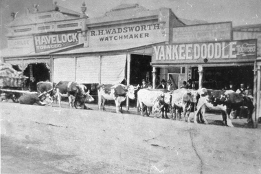
Photograph, Bullock Team Resting in Upper Main Street Stawell 1880
Bullock Team Resting in Main Street Stawell 1880. R.H. Wadsworth Watchmaker. Havelock Tobacco. Yankee Doodle Tobacco. Opposite the Albion Hotel Upper Main Street.stawell business -
 Stawell Historical Society Inc
Photograph, Mr G H Robson Monumental Works -- Corner of Lower Main Street and Napier Streets Stawell
G H Robson Monumental Works . Corner of Main and Napier Streets adjoining central Park. Trend and Brown Coachworks can be seen in Background in Lower Main Street.stawell trend brown coachbuilders photo parlor -
 Greensborough Historical Society
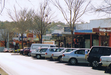
Photograph - Photograph - Digital Image, Marilyn Smith, Main Street Greensborough 24/08/2020, 24/08/2020
Digital image of Main Street Greensborough 24/08/2020, 11.25am. Taken during Covid lockdown, this image shows the usually busy Main Street with no cars or pedestrians.Part of a collection of miscellaneous historical images with a connection to the local area.Digital colour photograph. main street greensborough, covid pandemic, covid-19 -
 Sunbury Family History and Heritage Society Inc.
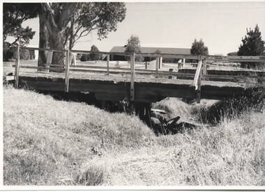
Photograph, Timber road bridge, May 1986
The small wooden bridge is spanning an arm of the Moonee Ponds Creek in its upper reaches in Greenvale near Woodlands Park, possibly along Providence Road.A non-digital black and white photograph with a white border of a timber bridge spanning a small creek, which is under a roadway. A country home is visible on the opposite side of the road.bridges, greenvale -
 Eltham District Historical Society Inc
Photograph, Liz Pidgeon, Heritage Excursion; Eltham Lower Park Walk and Talk, 1 July 2017, 1 July 2017
Information board: Hohnes Hill Flora & Fauna Reserve produced by Shire of Nillumbik and Parks Victoria which includes text and images with references to the Eltham Copper Butterfly. Newsletter No., 234, June 2017 Heritage Excursion - Saturday 1st July - Eltham Lower Park - Walk and Talk Eltham Lower Park has played an important part in the history of our area since the early days of European settlement when it was used by local residents as an informal racecourse. Prior to that its location at the junction of the Diamond Creek and the Yarra River made it an important meeting place for the Wurundjeri people. The park combines formal elements and sporting facilities with remnant bushland that is of environmental significance. It is home to sporting and horse riding clubs, popular play spaces and the Diamond Valley Miniature Railway, which attracts large numbers of visitors. The park will be the venue for our July excursion which will comprise a walk of about 3.5 km around the park and adjacent areas. Along the way we will discuss the history and natural history of the area. The path along the creek and the river provides a pleasant and scenic walk. This walk on Saturday 1st July is about 3.5 km in length and will take 2 to 2.5 hours. It will start at 2pm at the Main Road car park at the front of the park. (Melway ref 21 H 10). Born Digitalheritage excursion, activities, eltham district historical society, eltham lower park, hohnes hill, reserve, eltham copper butterfly, sign -
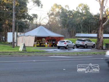 Eltham District Historical Society Inc
Photograph, Liz Pidgeon, Heritage Excursion; Eltham Lower Park Walk and Talk, 1 July 2017, 1 July 2017
Temporary flower vendor set up in a tent opposite Eltham Lower Park. The flower seller sets up on weekends and offers a convenient drive through service for customers. Goolge maps in February 2021 identified this site as Fleur De Feliss Roadside Store. Heritage Excursion - Saturday 1st July - Eltham Lower Park - Walk and Talk Eltham Lower Park has played an important part in the history of our area since the early days of European settlement when it was used by local residents as an informal racecourse. Prior to that its location at the junction of the Diamond Creek and the Yarra River made it an important meeting place for the Wurundjeri people. The park combines formal elements and sporting facilities with remnant bushland that is of environmental significance. It is home to sporting and horse riding clubs, popular play spaces and the Diamond Valley Miniature Railway, which attracts large numbers of visitors. The park will be the venue for our July excursion which will comprise a walk of about 3.5 km around the park and adjacent areas. Along the way we will discuss the history and natural history of the area. The path along the creek and the river provides a pleasant and scenic walk. This walk on Saturday 1st July is about 3.5 km in length and will take 2 to 2.5 hours. It will start at 2pm at the Main Road car park at the front of the park. (Melway ref 21 H 10). Newsletter No., 234, June 2017 Born Digitalheritage excursion, activities, eltham district historical society, eltham lower park, roadside store, flower vendor, fleur de feliss, tent, drive through, drive thru -
 Eltham District Historical Society Inc
Photograph, Opening of Eltham Library, 17 Aug 1971
The architect of Eltham's new library, Harold Bartlett of Messrs Leith & Bartlett Pty Ltd at the opening of the Eltham Library in 1971. The Eltham Branch of the Heidelberg Regional Library Service was opened on 17 August 1971 by Victoria’s Chief Secretary R. J. Hamer. The library was designed by the firm Leith and Bartlett and was the southern wing of the Shire of Eltham Offices in Main Road Eltham. Visitors entered a “book plaza” which embodies the display techniques of a bookshop. Through this area was located a quieter area for reference and the more “purposeful” reader. The library was opened as part of the Shire of Eltham’s centenary celebrations. Diamond Valley News, 24 August 1971 Wisdom of Solomon. "The architect of Eltham's new library, Mr Harold Bartett, at the opening of the library last week said: " Decisions to build such cultural builidngs as this with so little money and so many other basic items on the priority list are not taken without long hours of thoughtful debate demanding the wisdom of Solomon, the knowledge of a Moses, the business acumen of a money changer, the tender heart of a Rachael, the couriage of a David and last, but not least, the armour of a centurion." Thus, he described the attributes required in a municipal councillor. Mr Bartlett is a former councillor and is still honorary planner for the shire." H. E. Bartlett was on the Shire of Eltham Council 1954-1961. The library and Shire Offices were demolished exactly 25 years later in 1996. This photo forms part of a collection of photographs gathered by the Shire of Eltham for their centenary project book, "Pioneers and Painters: 100 years of the Shire of Eltham" by Alan Marshall (1971). The collection of over 500 images is held in partnership between Eltham District Historical Society and Yarra Plenty Regional Library (Eltham Library) and is now formally known as 'The Shire of Eltham Pioneers Photograph Collection.' It is significant in being the first community sourced collection representing the places and people of the Shire's first one hundred years.Digital imagesepp, shire of eltham pioneers photograph collection, shire of eltham, shire of eltham centenary, eltham library, opening day, h. bartlett, harold bartlett, sppech -
 Eltham District Historical Society Inc
Negative - Photograph, J.A. McDonald, Eltham-Yarra Glen Road, Lower Plenty footbridge, Sep. 1955
The Eltham-Yarra Glen Road as designated originated at the Shire of Eltham boundary at the Plenty River. West of the river the road was known as the Heidelberg-Eltham Road. The section from the Plenty River is now known as Lower Plenty Road which becomes Main Road. The footbridge no longer exists but was originally sited to the south, adjacent to the old Lower Plenty Bridge, now part of the Plenty River Trail. Record of various Shire of Eltham infrastructure works undertaken during the period of 1952-1962 involving bridge and road reconstruction projects, sometimes with Eltham Shire Council Project Reference numbers quoted. It was during this period that a number of significant improvements were made to roads and new bridges constructed within the shire that remain in place as of present day (2022). In many situations, the photos provide a tangible visible record of infrastructure that existed throughout the early days of the Shire. The album was put together by or under the direction of the Shire Engineer, J.A. McDonald.1955-09, eltham-yarra glen road, lower plenty footbridge, lower plenty, lower plenty bridge, lower plenty road, main road, plenty river trail, bridge construction, infrastructure, shire of eltham -
 Greensborough Historical Society
Photograph - Digital image, Frank Solomon, Parking, Main Street Greensborough, 04/06/2010
Parking on Main Street, Greensborough.Shows the changing face of the Greensborough shopping stripDigital copy of colour photographmain street greensborough -
 Malmsbury Historical Society
Photograph (Item), B/W Mrs George Main Dressed Up As School Inspector, Malmsbury c1927
People - "Main, Mrs George" -
 Stawell Historical Society Inc
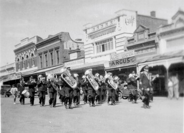
Photograph, Stawell Brass Band in Main Street 1948-1949
Brass Band - Main StreetReverse of Brownie Photo: 17stawell entertainment -
 Surrey Hills Historical Society Collection
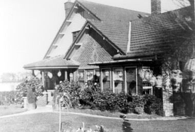
Photograph, Home and surgery of Dr William Langley Carrington, 174 Union Road, 1935
The building was erected in c 1913 as a home / surgery for Dr James L Blakie (1868-1937), who originally lived / practised across the road. It was designed by architect Arthur William Plaisted (1890-1965) and is an early example of attic-style Californian bungalow style. Dr Carrington ( 1900-1970) succeeded Dr Blakie and practised at 174 Union Road from 1930-1970. Now known as the Surrey Hills Medical Centre.Black and white photo of the surgery and home of Dr and Mrs William Langley Carrington at 174 Union Road on the corner of Guildford Road, Surrey Hills.. The exterior of the building is decorated with paper lanterns around the windows and veranda for the Empire Day celebrations in 1935. The building is 2 storey, of brick construction with a tiled roof and front porch. It has a bay window front right. Shadows indicate the photo was taken early morning in winter.medical services, guildford road, union road, dr william langley carrington, mr arthur plaisted, dr james landells blakie, californian bungalow, dr bill carrington -
Whitehorse Historical Society Inc.
Map, Springvale Road, 1990
Aerial photograph of cnr Springvale Road and Burwood Highway, south past Highbury Road, west to Middleborough Road and east to Morack Road Vermont South.Aerial photograph of cnr Springvale Road and Burwood Highway, south past Highbury Road, west to Middleborough Road and east to Morack Road Vermont South.Aerial photograph of cnr Springvale Road and Burwood Highway, south past Highbury Road, west to Middleborough Road and east to Morack Road Vermont South.aerial photographs, morack road, vermont south, burwood highway, burwood east, springvale road, burwood east, highbury road, burwood east, burwood east, vermont south -
 Upper Yarra Museum
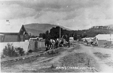
Negative Photographic Reproduction, Main St Yarra Junction
03039 PC Main street Yarra Junction. Team of horses pulling sawn timber on log bogies along the wooden Gilderoy tramline. Upper Yarra Shire 1888-1988 Centenary collection. Black & white Negative, scanned at 600 dpimain st yarra junction station masters house gilderoy tramway -
 Mission to Seafarers Victoria
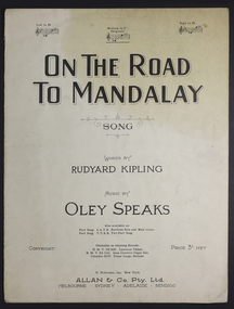
Booklet - Music Score, Allan & Co Prop Ltd, On the road to Mandalay
Original sheet music bookletRepresentative sheet music booklet of popular period Rudyard Kipling song.Paper booklet of song - sheet music and words.Title: "On The Road To Mandalay"music, sheet, mandalay, rudyard, kipling, song -
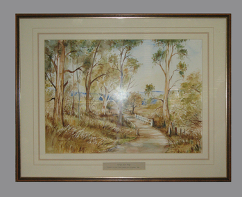 South Gippsland Shire Council
Framed watercolour painted by Bianca Biesuz, "Dryings Road Bridge", 1987
Painted by Bianca BiesuzCream card window mount with pink edging lines. Text panel cut out lower edge. Brown wood frame with gold edging. Painting portrays trees with a pathway through them, white bridge,"Dryings Road Bridge"