Showing 9252 items
matching bottoms a.
-
 Bendigo Military Museum
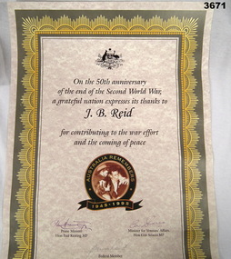
Certificate - CERTIFICATE, AUSTRALIA REMEMBERS, c.1994 - 1995
50th Anniversary of the end of WWII certificate issued to J B REID. Son of J B REID, Bruce Reid signature as Federal Member in 1995.Commemoration Certificate to recognize 50 years since end of WWII. Paper certificate, gold / khaki border, cream background with black print & coloured emblem.In the centre, emblem has words: “AUSTRALIA REMEMBERS 1945 - 1995” Bottom: “3 signatures”certificate, 50th, remembers -
 Bendigo Military Museum
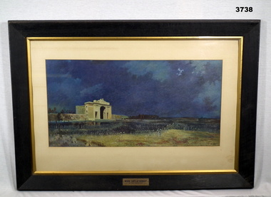
Print - PRINT, FRAMED, Will Longstaff, Post WW1
Black wooden frame with gold inner edge, glass front with brown paper backing. A colour copy of the Menin Gate at Midnight in colour by Will Longstaff is mounted with a cream border.On gold metal plate attached to bottom centre of frame: 'MENIN GATE AT MIDNIGHT' 'BY WILL LONGSTAFF'menin gate, ww1, framed print -
 Bendigo Military Museum
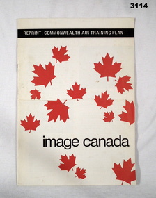
Booklet - BOOKLET, TRAINING, Reprint: Commonwealth Air Training Plan, c.1990
Soft cover booklet, white with red maple leaf images scattered over. Illustrated with black & white photos, four pages with a statistic card at end of the various air force involvement RCAF, RAF, RAAF, RNAT. 50th Anniversary of air training scheme.Black bar at top: Reprint: “Commonwealth Air Training Plan” Bottom: “Image Canada”training, booklet, canada -
 Bendigo Military Museum
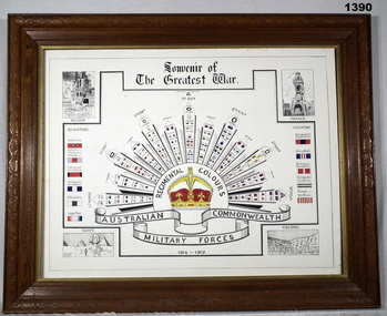
Poster - POSTER WW1, FRAMED, Post WW1
Large wooden frame, glass fronted, A depiction of the Rising Sun is centre with the arrows having colour patches in.Top: “Souvenir of the Greatest War” Bottom: “Aust Commonwealth Military Forces 1914-1919”documents - posters, frame accessories, colour patches, rising sun, -
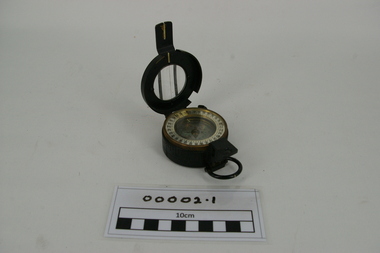 Frankston RSL Sub Branch
Compass
Type Mark 3 black plated prismatic compass, standard issue to Army personnel during the Vietnam Conflict. Circular circumferential scale, silver with black writing, graduated from 0-64 representing hundreds of MILS. Refer item 00002 and 00002.2There is an identifying number on the rear of the compass: 333739(top)and MK.3 AUST/2 (bottom)vietnam, compass, prismatic, conflict -
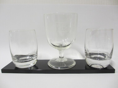 Seaworks Maritime Museum
Glass set
Set of three glasses on black stand. Glasses have flag design.Flag design on glasses "ACSC" On bottom of base: "WMA 49" "PMA 0170/2" -
 Glenelg Shire Council Cultural Collection
Artwork, other - Engraving - Portland Bay and township from observatory hill, AH. Fullwood, Portland, n.d
Hand coloured engraving taken from the publication 'Australasia Illustrated' 1884, the image shows Portland Bay and township from observatory hill. Narrow gold and black speckled Matt board around image, then wider cream matt board. Image backed with white matt board - certificate of Authenticity attached top left. (Reproduction)Front: Artists signatue, bottom left, 'Portland' printed centre border beneath engraving. -
 Greensborough Historical Society
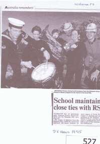
Newspaper clipping, School maintains close ties with RSL, 1995_08
Commemorates a visit to to Watsonia Primary school on 15th August 1995 by members of Watsonia RSL and members of the Army School of Music for a wreath laying ceremony.The ceremony was a part of the Australia Remembers celebrations commemorating the 50th Anniversary of the end of World War II.A black and white photocopy of a newspaper article featuring a large photograph of some ADF personel with school children.Some blue biro words at the bottom and the word "Watsonia" in pencil at the top right corner.watsonia rsl, watsonia primary school, army school of music, australia remembers -
 Glenelg Shire Council Cultural Collection
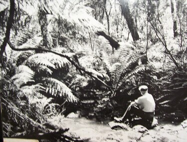
Photograph - Photograph - Fern Gully, n.d
Glenelg Shire Council recordsPicture of man seated on rock in creek, fern trees in background, Fern Gully, Lower Glenelg National Park.Front: Sticker bottom left. 'Fern Gully, Lower Glenelg National Park' - penportrait photography, fern gully -
Glenelg Shire Council Cultural Collection
Photograph - Photographs - Lighthouse, Portland Victoria, n.d
Two black and white photos of lighthouse at Portland. One slightly lighter than the other Identifying numbers 7891 a, bFront: 'LIGHTHOUSE PORTLAND VIC TOYE PHOTO' in white print, bottom of each photo -
Glenelg Shire Council Cultural Collection
Postcard - Postcard - Casterton, Victoria, 1960s
Sourced from Casterton Town Hall (former Shire of Glenelg)Postcard, black and white, Island Park, Casterton, showing football oval and pavilion, gum trees in backgroundFront: 'ISLAND PARK, CASTERTON, VIC', '4015' in bottom margin Back: Maker's stamptourism, travel, casterton -
Glenelg Shire Council Cultural Collection
Postcard - Postcard - Fancy dress ball, Portland Victoria, c. 1924
Black and white photo postcard. Fancy dress ball held at North Portland, 18th July, 1924. About 40 adults and children, all in fancy dress, sitting/standing in a group, outside a wooden buildingFront: 'FANCY DRESS BALL. NORTH PORTLAND. 18.7.24' -white script, bottom edge -
Glenelg Shire Council Cultural Collection
Postcard - Postcard - Mac's Hotel Portland, Victoria, n.d
Coloured postcard. Depiction of Mac's Hotel Portland, advertisement, map of location on reverse of postcard.Front: 'MAC'S MOTEL-HOTEL' - black print in white border, bottom edge of postcard -
Glenelg Shire Council Cultural Collection
Photograph - Photograph - Opening Deep Water Pier 13 Feb 1902, 1902
Black & white photo taken from shore to south pier. Squadron can be seen in background. Railway pier also visible to south of deep water pier. Town beach visible, with fishing fleet at anchor. Road to beach in foreground.Front: VANDA STUDIO, stamped bottom right. Back: EOC Cameron - red biro -
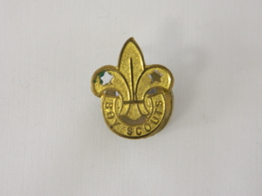 Kiewa Valley Historical Society
Badge Boy Scout, circa mid to late 1900's
This badge, which was used in the mid to late 1900's (Scouts started in Australia in 1909) clearly demonstrates that the families in the Kiewa Valley although slightly remote were still able to participate in one of the prime "boy" only social groups. The Boy Scouting movement brought together boys from all the socio-economic areas in the Australian population. The scouting group applied the concept of self sufficiency and friendship to all its membership. It was an avenue to cross the boundaries of distance and regional mores. Many of the boys in the Kiewa Valley and its regions would have been more "in tune" with the core principles of the scouting movement because being in a rural environment and "living on the land" was a day to day part of their life. What was an important aspect to they was the "mateship" and the belonging to a very large, and international, group of "like minded" boys. This avenue of interacting with a larger group of boys cut through the "small population" mores of a rural and at times isolated environment. This Boy Scouting activity was both mentally and physically significant to growing boys within the Kiewa Valley as it opened up the world to them.This brass badge has a front formed in a half circle base supporting a "Fleur de Leis" in a spear shape with "cut outs" at the appropriate places to provide the emphasis needed to project the form. Attached to the badge is a crescent moon shaped pronged frame for attaching the badge to lapels or collars or button eyelets. On the bottom scroll "BOY SCOUTS" and on the back type fastener "STOKES & SONS" below this "Melb".societies, boy scouts, apparel badges, numismatics badges -
 Kiewa Valley Historical Society
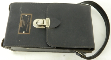
Case for G.P. Multimeter, Circa 1950
This leather case holder for a general purpose Multi-meter( KVHS 0307 (A)) was manufactured after 1950 and used by the SEC Vic (Kiewa Hydro Electricity Scheme) from that date until late 1900's. It was used to measure very small voltages associated with the operation of the various Hydro Generators. The readings were able to be shown by the resistor in use in the current circuit. During this time period, high quality testing instruments were either sourced from Europe or England. This particular carry case was manufactured in the Netherlands. This carry case for an analog General Purpose multi-meter which is quite a large (for a handheld mobile) apparatus.The bag however permits the easy monitoring of electrical variations within the large SEC Victoria Hydro Scheme's electrical generators. These generators are powered by the hydro force of "stored" water at a higher altitude. The establishment of both the NSW and Victorian Hydro schemes was achieved from the mid 1900's to the 1960's. At this point in time the need for additional power sources to quench both an industrial and domestic demand for electricity was purely an economic and not and environmental (carbon reduction) factor. This hydro scheme was instigated by "the Government of the day" as a bold move and was the major force of the World War II refugee and "technical" workforce inclusion of skilled and unskilled migration into the Australian environment. Although this mass "invasion" of workers with families was thought of in some circles as intrusive, the expansion of population post war years and its integration into the Australian rural sector, produced the multi- lingual multi-cultural diversity of later years.This leather case is to provide protection for this mobile G.P. Multimeter, therefore it is made from thick leather. It has a carrying strap from a thick "D" chromed link. This link is fastened to the main cover by a looped leather strip with a black coloured rivet. All the fasteners are either chrome or black coloured rivets. The front, which when opened back exposes fully the inside of the case. It is clip fastened to the lower section of the front piece which also can be pushed back allowing the meter to be removed from the frontal position. There is a strip retaining strap slightly higher from the mid point. This is fasted by a black press stud. There are two "L" shaped tin protrusions allowing the meter to slide only down the case until it rests on these shelves. This provides for an empty space for minimal storage,.On the front bottom and below the clasp is a tag "STATE ELECTRICITY COMMISSION OF VICTORIA TRANSMISSION DEPT."sec vic kiewa hydro scheme, alternate energy supplies, alpine population growth -
 Warrnambool and District Historical Society Inc.
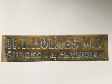
Brass Plate, Dr H I Holmes, Circa 1905
Doctor Horace Iles Holmes was born at Launceston Tasmania 09/08/1877. He was educated at Launceston High School and Tasmanian University and later at Melbourne University. After graduation he came to Warrnambool in 1905 and worked in the practice of Dr T F Fleetwood and took over the practice shortly afterwards along with the position of Honorary medical officer at Warrnambool Hospital and also health officer until 1944 and as an Honorary consulting medical officer from then until 1958. His practice which was located at " Ierne" opposite the Presbyterian Church in Spence St Warrnambool. He later moved to a new home and surgery at the corner of Spence Liebig st and Raglan parade which was later sold to Dr C B Berryman. A large medical clinic still operates from this site. Dr Holmes was a keen fisherman and a member of Rotary serving as district governor.This plate is a connection to a long standing doctor in the Warrnambool district. In his practice he would have treated many district people and as such this item has strong social and historical connections to the district. Rectangular brass plate engraved with name which has been coloured in black. There are six screw holes around the outer edge of the plaque. The back is plain .H.I. Holmes M.D. Surgeon & Physician. A stamped name at middle bottom edge is unreadablewarrnambool, warrnambool doctors, dr h i holmes, warrnambool history -
 Morongo Old Collegians
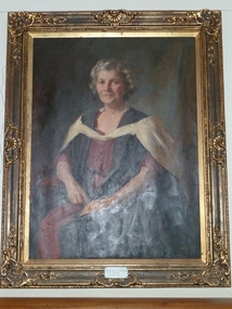
Portrait, William Dargie, Miss Lucy Shaw
This portrait was commissioned by Margaret Oddie, a Morongo Old Collegian.This is a portrait of Morongo GIrls College's second Principal (1942-1970)Large rectangular coloured oil painting encased in a guild-edged frameInscription on the bottom: "Miss Lucy Shaw MBE BA MACE Principal 1942-1970education, school, morongo, geelong, girls, principal -
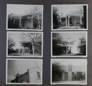 Glen Eira Historical Society
Album - Album page, Lirrewa, 1-3 Lirrewa Grove, Circa 1972
This photograph is part of the Caulfield Historical Album 1972. This album was created in approximately 1972 as part of a project by the Caulfield Historical Society to assist in identifying buildings worthy of preservation. The album is related to a Survey the Caulfield Historical Society developed in collaboration with the National Trust of Australia (Victoria) and Caulfield City Council to identify historic buildings within the City of Caulfield that warranted the protection of a National Trust Classification. Principal photographer thought to be Trevor Hart, member of Caulfield Historical Society. Most photographs were taken between 1966-1972 with a small number of photographs being older and from unknown sources. All photographs are black and white except where stated, with 386 photographs over 198 pages.From Victorian Heritage Database citation for Lirrewa - HO39 Tarqua and Stables, 1-3 Lirrewa Grove Caulfield South https://vhd.heritagecouncil.vic.gov.au/places/120932 (as at 26/10/2020) "Tarqua", now "Lirrewa", is situated at nos. 1-3 Lirrewa Grove, Caulfield South, and was built in 1886 for Montague William Langdon, son of the merchant Joseph Henry Langdon of nearby "Rosecraddock". It is historically and aesthetically significant. It is historically significant (Criterion A) as one of the Langdon family residences, comparing in Glen Eira also with "Rosecraddock" at 10 Craddock Avenue (1857) and "Hengar" at 356 Glen Eira Road (1889-90). It is aesthetically significant (Criterion E) for its capacity to demonstrate the stylistic influences prevailing at the time especially for substantial residences. At "Tarqua", the design acknowledges the prevailing popularity of the Italian Style in the shallow hipped roof form and symmetrical facade as well as the picturesque Gothic Revival style demonstrated especially by the use of pointed arches, fretted barges and the battlemented parapeted section. This latter style was particularly attractive to persons of means on account of its English precedents, the combination of influences being skillfully handled in this instance.Page 120 of Photograph Album with six photographs (all landscape) of views of Lirrewa, mostly including its garden.Handwritten: "Lirrewa" 1-3 Lirrewa Grove [top right] / 120 [bottom right]trevor hart, verandah, lirrewa, tarqua, 1880's, montague william langdon, italian style, shallow hipped roof, symmetrical facade, gothic revival, pointed arches, fretted barges, battlemented parapet, terraces, boom era, single storey, timber roof brackets, frieze, gables, cast iron ridging, lirrewa grove, cast iron work, caulfield, arches, parapets, gardens, houses, victorian style, caulfield south -
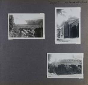
 Glen Eira Historical Society
Album - Album page, Labassa Conservatory, 21 Manor Grove, Circa 1972
This photograph is part of the Caulfield Historical Album 1972. This album was created in approximately 1972 as part of a project by the Caulfield Historical Society to assist in identifying buildings worthy of preservation. The album is related to a Survey the Caulfield Historical Society developed in collaboration with the National Trust of Australia (Victoria) and Caulfield City Council to identify historic buildings within the City of Caulfield that warranted the protection of a National Trust Classification. Principal photographer thought to be Trevor Hart, member of Caulfield Historical Society. Most photographs were taken between 1966-1972 with a small number of photographs being older and from unknown sources. All photographs are black and white except where stated, with 386 photographs over 198 pages. WHAT IS SIGNIFICANT? [From Victorian Heritage Database citation for Former Labassa Conservatory - H2005 Victorian Heritage Register http://vhd.heritage.vic.gov.au/places/result_detail/12504 (25/01/2021)] The former Labassa Conservatory is believed to have been built as part of the extensive reworking of the Labassa estate in c1890 for the new owner Alexander Robertson, proprietor of the Cobb and Co line. Robertson commissioned the architect JAB Koch to remodel the house, and Koch may have been responsible for the conservatory as well. Alternatively, the conservatory may have been imported. The gates installed at Labassa in 1890 were manufactured by the MacFarlane foundry of Glasgow, Scotland, a firm known to have manufactured conservatories. Around 1917 the glass house from 'Labassa', Caulfield was offered for sale to Malvern Council for its own gardens but the offer was declined. Following subdivision of the Labassa estate in the 1920s the conservatory was converted into a residence. The structure has a simple rectangular plan, with a brick base and superstructure of cast iron columns and roof trusses. The hipped roof is surmounted by an elaborately decorated gable structure. Most of the original glass has been replaced by metal sheeting. The decoration comprises pressed metal fascias including an egg and dart style cornice moulding, mullion mouldings and gable end panels with a rising sun motif. Cast iron ridgework and finials add to the lively roof form. Internally the floor appears to have been raised as part of the conversion work to a residence, and stained timber panelling introduced to provide room spaces. Boilers probably heated the conservatory in the colder months, but these do not survive.From Victorian Heritage Database citation for Former Labassa Conservatory - H2005 http://vhd.heritage.vic.gov.au/places/result_detail/12504 (25/01/2021) HOW IS IT SIGNIFICANT? The former Labassa Conservatory is of historical and architectural significance to the State of Victoria. WHY IS IT SIGNIFICANT? The former Labassa Conservatory is historically significant for its associations with the Labassa estate. Subdivision of the estate separated a number of outbuildings from the mansion. The former conservatory is significant as part of the large scale improvements carried out to the estate in the 1890s. The nineteenth century was the great age of conservatory designs, enabled by technological developments in heating, glazing and iron. Whilst conservatories were common in botanical gardens and universities, where they were primarily used for cultivating, studying, and experimenting with plants, they had also become an accessory of the wealthy on private estates. The former Labassa conservatory is architecturally significant as a rare example of a building type. Many Victorian mansion houses had attached conservatories, but detached conservatories were much less common. The only other detached example associated with a residence known to survive on its original site in Victoria is an earlier example at Warrock homestead, near Casterton. Conservatories attached to nineteenth century mansions are far more numerous. The Labassa example is very ornate, and its decoration draws on the versatility of pressed metal and cast iron. This highlights the dual purpose of the conservatory, as both a functional structure and a picturesque building on the Labassa estate. This building is unusual as an example converted to residential use. Page 130 of Photograph Album with one portrait photograph of Labassa's conservatory.Handwritten: "Labassa" conservatory 21 Manor Grove [top right] /130 [bottom right]bracketed eaves, caulfield north, labassa, balaclava road, orrong road, sylliott hill, alexander william robertson, ontario, john a. b. koch, john boyd watson, mouldings, 1920's, la bassa, manor grove, st kilda east, architects, john koch, greenhouses, gardens, plants, land subdivisions, gates, macfarlane foundry, brick, cast iron work, hipped roofs, gables, 1890's -
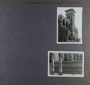 Glen Eira Historical Society
Album - Album page, Presentation Convent (ex "Cambria), Neerim Road, Circa 1972
This photograph is part of the Caulfield Historical Album 1972. This album was created in approximately 1972 as part of a project by the Caulfield Historical Society to assist in identifying buildings worthy of preservation. The album is related to a Survey the Caulfield Historical Society developed in collaboration with the National Trust of Australia (Victoria) and Caulfield City Council to identify historic buildings within the City of Caulfield that warranted the protection of a National Trust Classification. Principal photographer thought to be Trevor Hart, member of Caulfield Historical Society. Most photographs were taken between 1966-1972 with a small number of photographs being older and from unknown sources. All photographs are black and white except where stated, with 386 photographs over 198 pages. References cited above indicate that Cambria was demolished around 1974-1976 (2 dates given). Caulfield's Built Heritage states it was built for Cyril Godby with the National Trust (Victorian Heritage Database) saying it was built in 1888.Page 144 of Photograph Album with two photographs (one portrait, one landscape) of Presentation Convent, Neerim Road.Handwritten: Presentation Convent (ex- "Cambria") Neerim Road [top] / 144 [bottom right]trevor hart, presentation sisters, cambria, presentation convent, roseberry grove, glen huntly, neerim road, convent, victorian, polychrome bricks, mansions, gates, verandahs, balconies, towers, lookouts, cyril godby, house names -
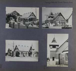 Glen Eira Historical Society
Album - Album page, Carnegie Methodist Church, Neerim Road, Circa 1972
This photograph is part of the Caulfield Historical Album 1972. This album was created in approximately 1972 as part of a project by the Caulfield Historical Society to assist in identifying buildings worthy of preservation. The album is related to a Survey the Caulfield Historical Society developed in collaboration with the National Trust of Australia (Victoria) and Caulfield City Council to identify historic buildings within the City of Caulfield that warranted the protection of a National Trust Classification. Principal photographer thought to be Trevor Hart, member of Caulfield Historical Society. Most photographs were taken between 1966-1972 with a small number of photographs being older and from unknown sources. All photographs are black and white except where stated, with 386 photographs over 198 pages. From Victorian Heritage Database citation for HO47 Uniting Church, 254 Neerim Road https://vhd.heritagecouncil.vic.gov.au/places/42432 (as at 28/10/2020) The former Methodist church (now Uniting church) complex at 252-54 Neerim Road, Carnegie, consists of the original timber church of 1886, the present brick Arts and Crafts influenced church of 1914, designed by A. Phipps Coles, the timber hall attached to the original church, built during the interwar period and the present brick hall of 1933, designed by J.F. Snell. From Victorian Heritage Database citation for HO47 Uniting Church, 254 Neerim Road https://vhd.heritagecouncil.vic.gov.au/places/42432 (as at 28/10/2020) The complex has aesthetic, historical and social significance. Its aesthetic value is derived from the extreme simplicity of the original church and the highly picturesque, eclectic, Arts and Crafts influenced character of the main church and hall. Its historical value rests in the early date of the original building and the manner in which the remaining buildings are representative of the principal period of settlement of the locality. The social significance derives from the use of the site as a place of worship since the commencement of the closer settlement of Carnegie from as early as 1886. Page 146 of Photograph Album with four photographs (3 landscape, 1 portrait) of Carnegie Methodist Church, Neerim Road.Handwritten: Carnegie Methodist Church Neerim Road [top right] / 146 [bottom right]trevor hart, neerim road, carnegie methodist church, church, toolambool road, wesleyan methodist church, breslin gallery, anthony breslin, 1910's, american romanesque, spire, half gabled tower, art, gallery, cafe, arched doorways, red brick, uniting church, carnegie, arts and craft style, a p coles, a coles, j f snell, j snell, halls -
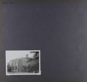 Glen Eira Historical Society
Album - Album page, Neerim Road, Circa 1972
This photograph is part of the Caulfield Historical Album 1972. This album was created in approximately 1972 as part of a project by the Caulfield Historical Society to assist in identifying buildings worthy of preservation. The album is related to a Survey the Caulfield Historical Society developed in collaboration with the National Trust of Australia (Victoria) and Caulfield City Council to identify historic buildings within the City of Caulfield that warranted the protection of a National Trust Classification. Principal photographer thought to be Trevor Hart, member of Caulfield Historical Society. Most photographs were taken between 1966-1972 with a small number of photographs being older and from unknown sources. All photographs are black and white except where stated, with 386 photographs over 198 pages. Property is included the City of Glen Eira's Amendment C190glen as HO177 Ida Villa. As of 18/03/2021, Amendment C190 is noted as "Approval Under Consideration" by the Minister of Planning.Page 147 of Photograph Album with one landscape photograph of a Victorian brick house on Neerim Road.Handwritten: Neerim Road [top left] / 234 [under photo] / 147 [bottom left]trevor hart, neerim road, arched windows, verandah, porch, decorative brackets, bull nosed verandah, cast iron columns, ross land sales, ross, carnegie, victorian style, cast iron work, polychrome bricks, brick houses, tessellated tiled deck, ida villa -
 Glen Eira Historical Society
Album - Album page, Glenmoore, St George's Road, Circa 1972
This photograph is part of the Caulfield Historical Album 1972. This album was created in approximately 1972 as part of a project by the Caulfield Historical Society to assist in identifying buildings worthy of preservation. The album is related to a Survey the Caulfield Historical Society developed in collaboration with the National Trust of Australia (Victoria) and Caulfield City Council to identify historic buildings within the City of Caulfield that warranted the protection of a National Trust Classification. Principal photographer thought to be Trevor Hart, member of Caulfield Historical Society. Most photographs were taken between 1966-1972 with a small number of photographs being older and from unknown sources. All photographs are black and white except where stated, with 386 photographs over 198 pages. From Victorian Heritage Database citation for HO59 Glenmoore, 1 St Georges Road Elsternwick https://vhd.heritagecouncil.vic.gov.au/places/35202 as at 30/10/2020 "Glenmoore" is locally significant as a surviving mid nineteenth century villa residence in the then fashionable bi-chromatic brick form. It is also important as the home of Hugh Moore who built several shops in nearby Glen Huntly Road and which remain as important contributors to the architectural character of the Elsternwick Shopping Centre.Victorian Heritage Database citation HO59 Glenmoore, 1 St Georges Road Elsternwick https://vhd.heritagecouncil.vic.gov.au/places/35202 An imposing two storeyed villa in bichrome brick with two storeyed timber posted verandah, coupled with cast iron lace frieze, spandrels and central tympanum enrichment. The hipped roof is in slate and has a prominent crean1 brick chimney stack forming part of the facade. Openings are flat arched although the entrance is round arched with a fan light. The south elevation has bayed windows. Two storeyed hip roofed additions are sympathetic and attached on the north side and at the rear. Inside, the staircase and stained glasswork with initials "HM" and family coat of arms are important surviving elements. INTEGRITY: Good, timber outbuildings of an early date, mature and spacious front garden includes early palm trees. Alterations include reconstruction of facade verandah including tiled pavement and front door on east side. Interior has a high level of integrity. Original grounds included adjoining "Carramar".Page 178 of Photograph Album with three photographs of Glenmoore, St Georges Road. Handwritten: "Glenmoore" 1 St George's Road [top right] / 178 [bottom right]trevor hart, chimneys, porch, mansion, slate roof, return verandah, stained glass, cast iron frieze, glenmoore, 1860's, hugh moore, glenmoore estate, double storey, elsternwick shops, st george's road, thomas watts, elsternwick, victorian style, protruding bay windows, cast iron work, bi-chromatic bricks, gardens, balconies, moore's buildings, glen huntly road, stairs, house names -
 Glen Eira Historical Society
Album - Album page, Ulupna Road, Circa 1972
This album was created in approximately 1972 as part of a project by the Caulfield Historical Society to assist in identifying buildings worthy of preservation. The album is related to a Survey the Caulfield Historical Society developed in collaboration with the National Trust of Australia (Victoria) and Caulfield City Council to identify historic buildings within the City of Caulfield that warranted the protection of a National Trust Classification. Principal photographer thought to be Trevor Hart, member of Caulfield Historical Society. Most photographs were taken between 1966-1972 with a small number of photographs being older and from unknown sources. All photographs are black and white except where stated, with 386 photographs over 198 pages. Page 196 of Photograph Album with one photograph of a Victorian house on Ulupna RoadHandwritten: Ulupna Street (crossed out) Road [ top right] / 196 [bottom right]trevor hart, chimneys, porch, garden, single storey, return verandah, ulupna road, ormond, decorative brackets, cast iron frieze, cast iron columns, full length windows, villa residence, cast iron work, victorian period -
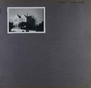 Glen Eira Historical Society
Album - Album page, Kinloch, Cobden Street, 7, Circa 1972
This photograph is part of the Caulfield Historical Album 1972. This album was created in approximately 1972 as part of a project by the Caulfield Historical Society to assist in identifying buildings worthy of preservation. The album is related to a Survey the Caulfield Historical Society developed in collaboration with the National Trust of Australia (Victoria) and Caulfield City Council to identify historic buildings within the City of Caulfield that warranted the protection of a National Trust Classification. Principal photographer thought to be Trevor Hart, member of Caulfield Historical Society. Most photographs were taken between 1966-1972 with a small number of photographs being older and from unknown sources. All photographs are black and white except where stated, with 386 photographs over 198 pages. Page 46 of Photograph Album with one photograph of Kinloch, a double storey house.Hand written: "Kinloch" 7 Cobden Street [top right] / 46 [bottom right] trevor hart, caulfield north, kinloch, cobden street, double storey houses, cars -
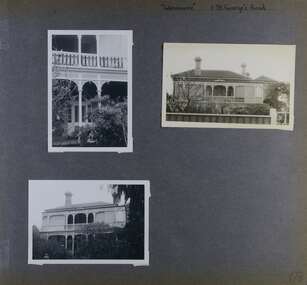
 Glen Eira Historical Society
Album - Album page, Glentana, Glen Huntly Road, 805, Circa 1972
This photograph is part of the Caulfield Historical Album 1972. This album was created in approximately 1972 as part of a project by the Caulfield Historical Society to assist in identifying buildings worthy of preservation. The album is related to a Survey the Caulfield Historical Society developed in collaboration with the National Trust of Australia (Victoria) and Caulfield City Council to identify historic buildings within the City of Caulfield that warranted the protection of a National Trust Classification. Principal photographer thought to be Trevor Hart, member of Caulfield Historical Society. Most photographs were taken between 1966-1972 with a small number of photographs being older and from unknown sources. All photographs are black and white except where stated, with 386 photographs over 198 pages. Melbourne Mansions database indicates that its architect may have been Charles Webb.Page 66 of Photograph Album with three exterior photographs (two portrait and one landscape) of Glentana, a single storey Victorian residence, focussing on views of its verandah.Hand written: "Glentana" 805 Glenhuntly Road [top right] / 66 [bottom right] trevor hart, brick, polychrome brickwork, cast iron frieze, decorative brackets, italianate, return verandah, glentana, glen huntly road, caulfield, cast iron work, verandahs, glenhuntly road, charles webb, glen tana, house names -
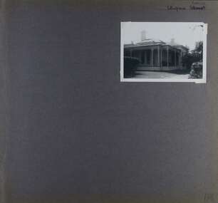
 Glen Eira Historical Society
Album - Album page, Booran Road, 30, Circa 1972
This photograph is part of the Caulfield Historical Album 1972. This album was created in approximately 1972 as part of a project by the Caulfield Historical Society to assist in identifying buildings worthy of preservation. The album is related to a Survey the Caulfield Historical Society developed in collaboration with the National Trust of Australia (Victoria) and Caulfield City Council to identify historic buildings within the City of Caulfield that warranted the protection of a National Trust Classification. Principal photographer thought to be Trevor Hart, member of Caulfield Historical Society. Most photographs were taken between 1966-1972 with a small number of photographs being older and from unknown sources. All photographs are black and white except where stated, with 386 photographs over 198 pages. From Glen Eira Heritage Management Plan 1996 by Andrew Ward: In 1888, John Leek, a trainer, owned Lot 15, measuring one and three quarter acres, in Booran Road, north side between Glen Eira and Neerim Roads. The land backed onto the Caulfield Racecourse Reserve. NAV was £45. In 1890 Leek built for his residence, a ten roomed brick house on the site. NAV was £200. Leek was the owner/trainer of "Ingliston" who won the Caulfield Cup in 1900. Upon the horse's death in 1901, Leek is understood to have defied tradition by spending £20 on boots for the "ragged urchins in Bourke Street" instead of "shouting" at the bar. By 1899, the property was owned and occupied by Alfred Merrill, a dentist and was known as "Andover". NA V had decreased to £ll0. By 1910, Leslie Macdonald, a gentleman had purchased the property and renamed it "Moidart". In 1910-11 Macdonald sold it to John Robertson. The property had extensive wood stables on its north-east boundary and several other outbuildings. The house continued to be described as "Brick, ten rooms" as it was in 1926 when it was owned and occupied by John Arthur, a managing director. The land measured la.2r.31p. and had a NAV of £235. Nine people lived there. In 1926, Arthur also owned the adjoining Lot 16. Other racehorses of note, known to have been stabled here include Sobar, Havelock, Proud, Future and Lord.Victorian Heritage Register https://vhd.heritagecouncil.vic.gov.au/places/13532 What is significant? Lord Lodge is a thoroughbred racehorse training complex adjacent to Caulfield Racecourse, established in 1890. The area immediately around the racecourse has been associated with horse racing activities and businesses servicing the industry since the development of the racecourse in late the 19th century. Lord Lodge was named by the present occupants after the champion racehorse Lord who was stabled there in the 1950s. In the early 20th century the property was known as 'Andover' and subsequently 'Moidart'. The site consists of a single storey brick Italianate villa, jockeys' quarters, stables and open day yards with direct access to Caulfield racecourse from the rear of the property. The villa of 10 rooms on bluestone foundations was constructed in 1890 by John Leek, a horse trainer who purchased the newly subdivided land in 1888. The house has many Victorian Italianate or Boom Style features although it is more modest than many villas of its style. It has an asymmetrical facade with a faceted bay window and a prominent central tower with low pitch pyramidal roof that provides a clear view of the racecourse. Other characteristic features include stilted segmented arches, bracketed eaves, stucco wall finish and cast cement ornamentation. A room has been added on the north-facing verandah in sympathetic style and finish. Internally the rooms are substantially intact with original marble fireplaces and intricate ceiling roses and cornices. An entrance toward the rear of the southern side of the house is said to be where the stable hands, jockeys and other staff lined up for their meals. In the southeast corner of the property, backing directly on to Caulfield racecourse, is a substantial late Victorian timber stable, probably constructed in the 1890s but first appearing on the property title in 1910. The stable has 12 stalls, a loft and brick pavement and jerkin head roof form with varnished pine-lined ceiling carried on a chamfered timber frame. It has an original roof lantern. The doors of the stalls are not the original sliding doors but swing doors obtained from a barn at Epsom Racecourse in Mordialloc prior to demolition. Outside the gambrel roof has fretted barges but the building is otherwise utilitarian. Timber throughout the stalls has been worn by chewing and rubbing of horses over the century of its use. In the southern half of the property are open day yards where the racehorses are kept during the day. The red brick, single storey jockeys' quarters to the rear of the villa were probably built around 1950. A small brick, possibly late Victorian structure on the eastern boundary thought to have originally been a gardening shed, has been converted to a stable of two stalls. Modern concrete brick stables fill the northeast portion of the property. At the front of the property two Moreton Bay Figs (Ficus macrophylla), probably planted in the late 19th century, provide shade for horses in the day yards. In the 1890s John Leek sold the property, relocating his training facility to one of the newly established racecourses at Mentone or Mordialloc (Epsom). By 1899, the property was owned and occupied by Alfred Merrill, a dentist, who named the property 'Andover'. In 1910 it was purchased by Leslie McDonald, a gentleman, and renamed 'Moidart'; sold in 1910-1911 to John Robertson; and again in 1926 to John Arthur, a racehorse owner. The Victorian Amateur Turf Club purchased the property in the late 1930s and since this time has been leased to racehorse trainers. It is unclear whether the property operated as a training facility between 1899 - 1926. Several notable trainers and jockeys are associated with Lord Lodge. The best known is Arthur 'Scobie' Breasley, Australia's most successful jockey who was apprenticed to trainer Pat Quinlan at Lord Lodge (then 'Moidart') from 1928 - 1935. Breasley rode winners of the Caulfield Cup in four successive years 1942-45 and again in 1952. John Leek, the original owner of Lord Lodge trained Ingliston, the 1900 Caulfield Cup winner. Along with 'Lord' a number of well known racehorses including Sobar, Havelock, Proud and Future were trained at Lord Lodge .....Page 40 of Photograph Album with three landscape photographs of the exterior of this house.Handwritten: 30 Booran Road [top right hand corner] / 40 [bottom right]trevor hart, jenny o'donnell, booran road, mansion, caulfield east, ingliston, sobar, havelock, proud, future, lord, andover, moidart, lord lodge, grace darling, caulfield racecourse reserve, victorian amateur turf club, historic buildings register, national estate register, caulfield cup, horses, stables, horse racing, racehorses, outbuildings, racehorse trainers, depression, 1890s, brick houses, mansions, towers, verandahs, stained glass, italianate style, victorian style, architectural features, architectural styles, john leek, leslie macdonald, john arthur, john robertson, alfred merrill, jenny odonnell -
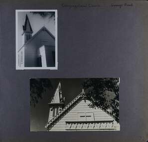 Glen Eira Historical Society
Album - Album page, Congregational Church, Grange Road, Circa 1972
This photograph is part of the Caulfield Historical Album 1972. This album was created in approximately 1972 as part of a project by the Caulfield Historical Society to assist in identifying buildings worthy of preservation. The album is related to a Survey the Caulfield Historical Society developed in collaboration with the National Trust of Australia (Victoria) and Caulfield City Council to identify historic buildings within the City of Caulfield that warranted the protection of a National Trust Classification. Principal photographer thought to be Trevor Hart, member of Caulfield Historical Society. Most photographs were taken between 1966-1972 with a small number of photographs being older and from unknown sources. All photographs are black and white except where stated, with 386 photographs over 198 pages. This church has since become the Greek Orthodox Church. From Victorian Heritage Database: Citation for Greek Orthodox Church HO84 https://vhd.heritagecouncil.vic.gov.au/places/43587 (as at 19/10/2020) The former Primitive Methodist, later Congregational, church at 152 Grange Road, Glenhuntly, is a small timber building, erected in 1885 (89?) in South Melbourne and relocated to Glenhuntly in 1909. It is a highly individual picturesque timber structure with distinctive spire and timber enrichment. It has aesthetic, historical and social significance. Its aesthetic value is derived from the choice of materials and picturesque Gothic Revival character showing American influence. Its historical value is derived from its survival as a rare example of a Primitive Methodist Church building whilst its social value hinges on its early roles as a place of worship for the Primitive Methodists in South Melbourne and the Congregationalists in Glenhuntly.Page 72 of Photograph Album with two photographs (one portrait and one landscape) of the upper exterior and tower of the Congregational Church on Grange RoadHand written: Congregational Church, Grange Road [top right] / 72 [bottom right] trevor hart, congregational church, grange road, gothic revival, carnegie, glen huntly, glenhuntly, greek orthodox church, primitive methodist church, spire, timber buildings -
 Federation University Historical Collection
Photograph - Photograph (Black & White), Mines Department, Back View School of Mines Ballarat, c 1900
The Albert Street end of the Ballarat School of Mines Campus included the Gauge Tower [designed by Henry R. Caselli] and the Mining Laboratory. The buildings shown along Albert Street have been demolished to make way for the M.B. John Building and the Flecknoe Building. Black and white photograph mounted onto green card. Shows the Ballarat School of Mines from Albert Street. The Henry Caselli designed Gauge tower is located on the left hand side of the photo, and Albert Street is an unmade dirt road.Written onto bottom of photo 'Back View School of Mines Ballarat. Mines Dept.ballarat school of mines, albert street, henry caselli, henry richards caselli, hr caselli