Showing 3905 items matching "bricker"
-
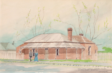
 City of Moorabbin Historical Society (Operating the Box Cottage Museum)
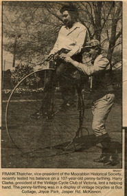
Newspaper - Photograph, Newspaper 'Reconstruction Box Cottage' celebration 1987, 1987
The original small, pioneer cottage was built in the late 1840s to early1850s, by an unknown pioneer. It was located on part of a 30 Acre allotment that was originally part of Dendy’s Special Survey granted in 1841. The doors and window sashes, (made of red deal joinery timber), as well as the brass locks and fittings, are from the original cottage, and were imported from England. The fire-place bricks are from the original cottage, and are sun-dried, (not kiln fired), and are hand-made. Convict marks can be seen on two bricks. There is a small display of external cladding shingles from the original pioneer cottage. These shingles were hand-split, and most likely made from locally collected timber The nails included in this display were used to fasten the shingles on the original cottage, and are also hand-made. The cottage was occupied by William Box and family from 1865 until 1914 when it was sold to William Reitman who resided there until 1950. The enamel nameplate, “Colonial”, on the wall of the cottage, was the name chosen for the original pioneer cottage by Mr William Reitman, when he purchased the property in around 1915, for 1200 Pounds approximately. In 1974 Mr Lewis, a timber specialist, found the dilapidated building on property he had recently purchased in Jasper Rd and suggested it be reconstructed and relocated. Moorabbin Council agreed and the cottage was rebuilt just about 250 metres from its original site. The cost of the rebuild was met by 'Victoria's 150th Committee, plus a small grant from the City of Moorabbin, and Mr Laurie Lewis donated much of the timber for the reconstruction. The re-constructed cottage plan has followed faithfully the original dimensions, and plan of the original pioneer cottage, and as many original items from that cottage’s long occupation have been incorporated. The photographs in Album 1 record the progress of the reconstruction from February 1984 to the First Public Open Day November 18th 1984 and this Celebration in October 1987This Newspaper photograph of Frank Thatche,r CMHS Vice President, riding a penny - farthing during a display by the Vintage Bicycle Club in 1987 is an example of the community events held at Box Cottage after the Reconstruction was completed. The Moorabbin Standard Newspaper was the local paper for the City of Moorabbin until it was absorbed by The Leader Newspaper Group Ltd. late 20thCentury. Mrs H. Deam and Mr A. Smith, CMHS members, took these photographs to record the progress of the ‘Reconstruction’ from February 1984 to November 1984. Although 'Box Cottage' is a re-construction, it is an unique museum that, being located in the midst of a modern community in Ormond Victoria, can educate and demonstrate many aspects of the early settler’s way of life in Victoria. As such, it is an invaluable resource for students and all kinds of visitors. 1 Black and white photograph in the Moorabbin Standard Newspaper October 1987 of Frank Thatcher , CMHS Vice-President, riding a 107 year old Penny- farthing bicycle at Box Cottage Joyce Park Ormond. He is assisted by Mr Harry Clarke, President of the Vintage Cycle Club of Victoria.brighton, moorabbin, highett, ormond, mckinnon, cottages, pioneers, colonial, dendy henry, box william, box elizabeth, reitman william, convicts lewis timber co. ltd., deam h, smith arthur, museums, box alonzo, moody & smith builders highett, the moorabbin standard newspaper, the leader newspaper pty ltd., thatcher frank, clarke harry, vintage bicycle club victoria, bicycles, penny-farthing bicycles -
 City of Moorabbin Historical Society (Operating the Box Cottage Museum)
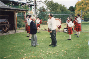
Photograph, Colour ' Reconstruction Box Cottage' Moorabbin Pipe Band 1992, 1992
The original small, pioneer cottage was built in the late 1840s to early1850s, by an unknown pioneer. It was located on part of a 30 Acre allotment that was originally part of Dendy’s Special Survey granted in 1841. The doors and window sashes, (made of red deal joinery timber), as well as the brass locks and fittings, are from the original cottage, and were imported from England. The fire-place bricks are from the original cottage, and are sun-dried, (not kiln fired), and are hand-made. Convict marks can be seen on two bricks. There is a small display of external cladding shingles from the original pioneer cottage. These shingles were hand-split, and most likely made from locally collected timber The nails included in this display were used to fasten the shingles on the original cottage, and are also hand-made. The cottage was occupied by William Box and family from 1865 until 1914 when it was sold to William Reitman who resided there until 1950. The enamel nameplate, “Colonial”, on the wall of the cottage, was the name chosen for the original pioneer cottage by Mr William Reitman, when he purchased the property in around 1915, for 1200 Pounds approximately. In 1974 Mr Lewis, a timber specialist, found the dilapidated building on property he had recently purchased in Jasper Rd and suggested it be reconstructed and relocated. Moorabbin Council agreed and the cottage was rebuilt just about 250 metres from its original site. The cost of the rebuild was met by 'Victoria's 150th Committee, plus a small grant from the City of Moorabbin, and Mr Laurie Lewis donated much of the timber for the reconstruction. The re-constructed cottage plan has followed faithfully the original dimensions, and plan of the original pioneer cottage, and as many original items from that cottage’s long occupation have been incorporated. The photographs in Album 1 record the progress of the reconstruction from February 1984 to the First Public Open Day November 18th 1984 and this event in 1992These 3 photographs show the 'Box Cottage' in 1992 after the 'Reconstruction' . The Moorabbin Pipe Band is shown performing at an Open Day with Cr. Flavell, Moorabbin City Council and Mr Reid CMHS. Mrs H. Deam and Mr A. Smith, CMHS members, took these photographs to record the progress of the ‘Reconstruction’ from February 1984 to November 1984 and this event in 1992 Although 'Box Cottage' is a re-construction, it is an unique museum that, being located in the midst of a modern community in Ormond Victoria, can educate and demonstrate many aspects of the early settler’s way of life in Victoria. As such, it is an invaluable resource for students and all kinds of visitors. 2 x colour photographs of The Moorabbin Pipe Band performing at an Open Day in 1992, with Cr. Flavell, Moorabbin City Council and Mr Reid CMHS , at the 'Reconstructed Box Cottage' in Joyce Park. Ormond 1 x colour photograph of the 'Reconstructed Box Cottage ' c 1992written on back ; a) Moorabbin Pipe Band / Mr Reid & Cr. Flavell / 1992 ; b) Moorabbin Pipe Band 1992 ; brighton, moorabbin, highett, ormond, mckinnon, cottages, pioneers, colonial, dendy henry, box william, box elizabeth, reitman william, convicts lewis timber co. ltd., deam h, smith arthur, museums, box alonzo, moody & smith builders highett, the moorabbin standard newspaper, the leader newspaper pty ltd., fox max cr. , lewis laurie, moorabbin city council, national trust, connard geoff mlc, lawson geoff mlc, flavell robert cr. moorabbin city council, joyce park, jasper road, moorabbin pipe band, -
 City of Moorabbin Historical Society (Operating the Box Cottage Museum)
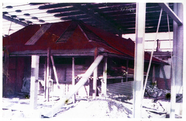
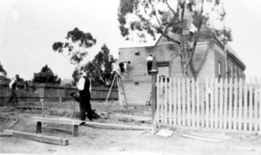
Photograph, colour 1984 Box Cottage dismantled, 1984
The original small, pioneer cottage was built in the late 1840s to early1850s, by an unknown pioneer. It was located on part of a 30 Acre allotment that was originally part of Dendy’s Special Survey granted in 1841. The doors and window sashes, (made of red deal joinery timber), as well as the brass locks and fittings, are from the original cottage, and were imported from England. The fire-place bricks are from the original cottage, and are sun-dried, (not kiln fired), and are hand-made. Convict marks can be seen on two bricks. There is a small display of external cladding shingles from the original pioneer cottage. These shingles were hand-split, and most likely made from locally collected timber The nails included in this display were used to fasten the shingles on the original cottage, and are also hand-made. The cottage was occupied by William Box and family from 1865 until 1914 when it was sold to William Reitman who resided there until 1950. The enamel nameplate, “Colonial”, on the wall of the cottage, was the name chosen for the original pioneer cottage by Mr William Reitman, when he purchased the property in around 1915, for 1200 Pounds approximately. In 1974 Mr Lewis, a timber specialist, found the dilapidated building on property he had recently purchased in Jasper Rd and suggested it be reconstructed and relocated. Moorabbin Council agreed and the cottage was rebuilt just about 250 metres from its original site. The cost of the rebuild was met by 'Victoria's 150th Committee, plus a small grant from the City of Moorabbin, and Mr Laurie Lewis donated much of the timber for the reconstruction. The re-constructed cottage plan has followed faithfully the original dimensions, and plan of the original pioneer cottage, and as many original items from that cottage’s long occupation have been incorporated. The photographs in Album 1 record the progress of the reconstruction from February 1984 to the First Public Open Day November 18th 1984These 3 photographs show the 'Box Cottage' dismantled in the Lewis Timber Co Ltd property at the commencement of the 'Reconstruction in February 1984. Mrs H Deam and Mr A. Smith, CMHS members, photographed the progress of the 'Reconstruction' from February 1984 to November 1984. Although 'Box Cottage' is a re-construction, it is an unique museum that, being located in the midst of a modern community in Ormond Victoria, can educate and demonstrate many aspects of the early settler’s way of life in Victoria. As such, it is an invaluable resource for students and all kinds of visitors. 3 x Colour photographs of the 'Box Cottage' dismantled in sections, lying on the floor of the storage building of the Lewis Timber Co Ltd Jasper Road Ormond c 1984nilbrighton, moorabbin, cottages, pioneers, ormond, colonial, mckinnon, dendy henry, box william, box elizabeth, reitman william, convicts lewis timber co. ltd., deam h, museums, box alonzo, smith a, -
 City of Moorabbin Historical Society (Operating the Box Cottage Museum)
Photograph, Colour, 'Box Cottage' in Lewis Yard 1977, 1977
The original small, pioneer cottage was built in the late 1840s to early1850s, by an unknown pioneer. It was located on part of a 30 Acre allotment that was originally part of Dendy’s Special Survey granted in 1841. The doors and window sashes, (made of red deal joinery timber), as well as the brass locks and fittings, are from the original cottage, and were imported from England. The fire-place bricks are from the original cottage, and are sun-dried, (not kiln fired), and are hand-made. Convict marks can be seen on two bricks. There is a small display of external cladding shingles from the original pioneer cottage. These shingles were hand-split, and most likely made from locally collected timber The nails included in this display were used to fasten the shingles on the original cottage, and are also hand-made. The cottage was occupied by William Box and family from 1865 until 1914 when it was sold to William Reitman who resided there until 1950. The enamel nameplate, “Colonial”, on the wall of the cottage, was the name chosen for the original pioneer cottage by Mr William Reitman, when he purchased the property in around 1915, for 1200 Pounds approximately. In 1974 Mr Lewis, a timber specialist, found the dilapidated building on property he had recently purchased in Jasper Rd and suggested it be reconstructed and relocated. Moorabbin Council agreed and the cottage was rebuilt just about 250 metres from its original site. The cost of the rebuild was met by 'Victoria's 150th Committee, plus a small grant from the City of Moorabbin, and Mr Laurie Lewis donated much of the timber for the reconstruction. The re-constructed cottage plan has followed faithfully the original dimensions, and plan of the original pioneer cottage, and as many original items from that cottage’s long occupation have been incorporated. The photographs in Album 1 record the progress of the reconstruction from February 1984 to the First Public Open Day November 18th 1984 This photograph shows the 'Box Cottage' in the Lewis Timber Co Ltd property in 1977 where it is being used as a storage room for timber. Mrs H Deam and Mr A. Smith, CMHS members, photographed the progress of the 'Reconstruction' from February 1984 to November 1984. Although 'Box Cottage' is a re-construction, it is an unique museum that, being located in the midst of a modern community in Ormond Victoria, can educate and demonstrate many aspects of the early settler’s way of life in Victoria. As such, it is an invaluable resource for students and all kinds of visitors.A colour photograph of the ‘Cottage’ in the yard of the Lewis Timber Co P/L Jasper Road, Ormond, in 1977 where it is being used as a storage area for timber.brighton, moorabbin, cottages, pioneers, ormond, colonial, mckinnon, dendy henry, box william, box elizabeth, reitman william, convicts lewis timber co. ltd., deam h, museums, box alonzo, smith a, -
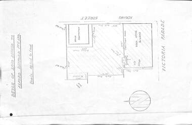
 City of Moorabbin Historical Society (Operating the Box Cottage Museum)
A laminated , photocopy of the ‘Plan of Box Cottage c 1865 ‘, 1985
The original small, pioneer cottage was built in the late 1840s to early1850s, by an unknown pioneer. It was located on part of a 30 Acre allotment that was originally part of Dendy’s Special Survey granted in 1841. The doors and window sashes, (made of red deal joinery timber), as well as the brass locks and fittings, are from the original cottage, and were imported from England. The fire-place bricks are from the original cottage, and are sun-dried, (not kiln fired), and are hand-made. Convict marks can be seen on two bricks. There is a small display of external cladding shingles from the original pioneer cottage. These shingles were hand-split, and most likely made from locally collected timber The nails included in this display were used to fasten the shingles on the original cottage, and are also hand-made. The cottage was occupied by William Box and family from 1865 until 1914 when it was sold to William Reitman who resided there until 1950. The enamel nameplate, “Colonial”, on the wall of the cottage, was the name chosen for the original pioneer cottage by Mr William Reitman, when he purchased the property in around 1915, for 1200 Pounds approximately. In 1974 Mr Lewis, a timber specialist, found the dilapidated building on property he had recently purchased in Jasper Rd and suggested it be reconstructed and relocated. Moorabbin Council agreed and the cottage was rebuilt just about 250 metres from its original site. The cost of the rebuild was met by 'Victoria's 150th Committee, plus a small grant from the City of Moorabbin, and Mr Laurie Lewis donated much of the timber for the reconstruction. The re-constructed cottage plan has followed faithfully the original dimensions, and plan of the original pioneer cottage, and as many original items from that cottage’s long occupation have been incorporated. The photographs in Album 1 record the progress of the reconstruction from February 1984 to the First Public Open Day November 18th 1984Mrs H Deam and Mr A. Smith, CMHS members, photographed the progress of the 'Reconstruction' from February 1984 to November 1984. Although 'Box Cottage' is a re-construction, it is an unique museum that, being located in the midst of a modern community in Ormond Victoria, can educate and demonstrate many aspects of the early settler’s way of life in Victoria. As such, it is an invaluable resource for students and all kinds of visitors. A laminated , photocopy of the ‘Plan of Box Cottage c 1865 ‘ Hand drawn layout of 2 houses with shrubs, trees, plants, wells, gardens on the Box Cottage site c1930 as recalled by Stefanie Rietman Rennick. brighton, moorabbin, cottages, pioneers, ormond, colonial, mckinnon, dendy henry, box william, box elizabeth, reitman william, convicts lewis timber co. ltd., deam h, museums, box alonzo, smith a, -
 City of Moorabbin Historical Society (Operating the Box Cottage Museum)
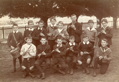
Photograph,Black & White Cheltenham State School Fife & Drum Band c1908, c1908
1855 Stephen Charman donated land to the Methodist Church so that a School could be established to educate the children of the early settler market gardeners and farmers in the Cheltenham area . Education was valued by the general community and as well as schools they established mechanics Institutes and Libraries in Moorabbin Shire. Cheltenham State School No. 84 was among the first schools in Melbourne. Stephen Charman, 1821-1906 a market gardener, donated land for the first Methodist Chapel, Cemetery and School in Charman Rd Cheltenham 1855. The enrolment was 36 pupils with Mr Frederick Meeres as Teacher. 1863 the school is called Beaumaris Common School No 84 with 70 pupils and Walter Meeres as Teacher. 1869 another 2 acres in Charman Road were granted by the Education Board and brick building built . 1872 State School 84 Beaumaris was increasing enrollments and 1878 a new brick school was built to accommodate 174 pupils and the name changed to Cheltenham State School No.84 1894 Mentone State School No.2950 amalgamated with Cheltenham SS No.84. 1910 the buildings were in disrepair, overcrowding was increasing and renovations were made 1912 with further additions in 1925 and 1937. Post WW11 extra prefabricated Classrooms were added as enrollment increased to 1038 in 1955.. Cheltenham East State School 4754 was opened as housing development spread over the City of Moorabbin . (J.Larson Sandringham HS) Probably due to the Scottish heritage of many early settlers the Fife & Drum Band was established at the West Beaumaris (Cheltenham) State School . The Fife is similar to the piccolo, and usually made of wood, consisting of a tube with 6 finger holes and an embouchure hole that produces sound when blown across.The fife was used in folk music traditions to accompany dancing by all social classes. Also in the Military where drums accompanied the fife and originally these 'boy soldier ' bands were used to signal manouevres in the field for the infantry. Later Fife & Drum bands were used for marching bands in schools and community groups, 1855 Stephen Charman donated land to the Methodist Church so that a School could be established to educate the children of the early settler market gardeners and farmers in the Cheltenham area . Education was valued by the general community and as well as schools they established mechanics Institutes and Libraries in Moorabbin Shire. Cheltenham State School No. 84 was among the first schools in Melbourne.Black & White photograph of pupils at West Beaumaris (Cheltenham) State School No.84 in the boy's Fife and Drum Band c 1908Back Handwritten Mrs Whelan / Beaumariswhelan r, marriott geoff, meeres frederick, cheltenham state school no.84, education, keys robert, holloway josiah, king brothers, smith j l; smith mary ann, stanley helen, chaff cutter, horse drawn carts, toll gates brighton, motor cars 1900, steam engines, early settlers, bentleigh, parish of moorabbin, city of moorabbin, county of bourke, moorabbin roads board, shire of moorabbin, henry dendy's special survey 1841, were j.b.; bent thomas, o'shannassy john, king richard, charman stephen, highett william, ormond francis, maynard dennis, market gardeners, vineyards, orchards -
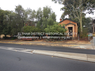 Eltham District Historical Society Inc
Photograph, Jim Connor, Former CBA branch, 810 Main Rd, Eltham, 6 January 2000
The little yellow and orange brick at 810 Main Road, Eltham, just in front of the Uniting Church (formerly Methodist Church) on the corner of John Street in more recent times has been used as an Opportunity Shop by the Eltham Uniting Church however the operations outgrew the tiny building and the shop moved to inside the Church hall. This building was once the Eltham agency of the Commercial Bank of Australia. Measuring just 3.6 x 4.5 m inside, it was built in 1878 by George Stebbing and is said to have stored gold in the early Eltham-Research mining days. It was also once the scene of an armed hold-up. Thursday, December 15, 1949, the quiet little bank was embroiled in an infamous wild shoot-out between a daring thief and two bank officers. Today, the building still carries the scars ; a bullet hole remains visible in a cedar bench testifying to the events that played out that day.jim connor collection, uniting church, main road, eltham, cba bank, opportunity shop, 2020-01-06 -
 Eltham District Historical Society Inc
Photograph, Jim Connor, Former CBA branch, 810 Main Rd, Eltham, 10 July 2023
The little yellow and orange brick at 810 Main Road, Eltham, just in front of the Uniting Church (formerly Methodist Church) on the corner of John Street in more recent times has been used as an Opportunity Shop by the Eltham Uniting Church however the operations outgrew the tiny building and the shop moved to inside the Church hall. This building was once the Eltham agency of the Commercial Bank of Australia. Measuring just 3.6 x 4.5 m inside, it was built in 1878 by George Stebbing and is said to have stored gold in the early Eltham-Research mining days. It was also once the scene of an armed hold-up. Thursday, December 15, 1949, the quiet little bank was embroiled in an infamous wild shoot-out between a daring thief and two bank officers. Today, the building still carries the scars ; a bullet hole remains visible in a cedar bench testifying to the events that played out that day.jim connor collection, uniting church, main road, eltham, cba bank, opportunity shop, 2023-07-10 -
 Lara RSL Sub Branch
Photograph, Mont Park Military Hospital 1919
An agreement was made with the Defence Department in 1914 for the latter to erect the Mont Park central block (the "Chronic Wards") for use as a Military Hospital, and for it later to revert to the State as portion of Mont Park Hospital. The buildings now known as the Chronic Wards were completed in this way in 1916 and used as the Australian General Hospital no. 16 for the duration of the war. One wing of this building was set aside for mental patients during this period. The Military Mental Hospital was built in 1919 to accommodate 84 patients who were suffering from psychiatric conditions as a result of their service in World War I. It was occupied by military patients until 1933 when they were transferred to Commonwealth facilities. The Military Mental Hospital consisted of a two storey brick Administration Building with two single-storey pavilion wards and a single-storey kitchen-dining room pavilion at the rear, connected with covered ways. The ward sections of the Military Mental Hospital have undergone considerable alteration.Lara R.S.L. received the picture miss-labelled as "The Heidelberg Repatriation Hospital - 1919 ' after some research it was relabeled as belonging to Mont Park Military Hospital "Chronic Wards" Rectangular shaped glass covered photo frame showing a photo of part of Mont Park Hospital in 1919.Mont Park Hospital 1919. Donated by Ron Ellis 9th September 1984.hospitals, world war one, lara r.s.l. heidelberg repatriation hospital, photos., mont park hospital -
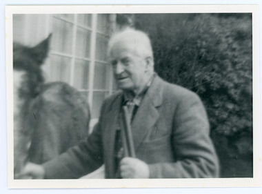 Mt Dandenong & District Historical Society Inc.
Photograph, Edward John Price 1973
John Lundy-Clarke grew up in the Kalorama/Mt Dandenong area and later in life (1972-74) began to write a comprehensive history of the district working from an original settlement map in an effort to cover all areas. Edward John Price (Ted)(1899-1974) was the third child of Edward Joseph and Annie Price. He lived a very industrious life in the area. When the new CRB road cut through the family land Edward John established a Corn and Produce store on a level area adjoining the new road . Along with his brother Charlie, Ted took up road contracting and formed Grange Road in 1923. They also took up contracts to metal the CRB road between The Gap and Olinda. Edward John married Myra Wilson in 1930. They lived in the first brick home built in the district. They had two sons, Edward Joseph 2nd and Alan.Black and white photograph showing an old man dressed in a jacket holding the reins of a horse. Reverse of photograph has handwritten description by John Lundy-Clarke.Edward John Price 1973. Son of Edward Joseph & Annie Ada nee Ross. Born 1899 died 1974. Farmer, Carrier, Sawmiller, Contractor, Quarry Owner, Shop Proprietor (Kew Junction 1935). Father of Alan & Edward J.edward john price, myra wilson, edward joseph price, annie price, alan price, charles price, grange road, crb road -
 Bayside Gallery - Bayside City Council Art & Heritage Collection
Work on paper - watercolour, John C. Paul, Adam Lindsay Gordon cottage c. 1870, 1973
The famous Australian poet Adam Lindsay Gordon (1833-1870) lodged for seventeen months in this cottage, located at 10 Lewis Street, Brighton. He and his wife Margaret lived here from 1869 until Gordon took his life on the Brighton foreshore in June 1970. Adam Gordon Lindsay was the first Australian poet to gain considerable recognition overseas and has been credited for beginning a national school of Australian poetry. His poetry reflected his love of the bush, a sense of humour, but also his battle with depression. In addition to being a poet, Lindsay was also a skilled horseman, police officer and politician. In 1946, the cottage at 10 Lewis Street was demolished. Local poet Mr Cyril Good, an ardent admirer of Adam Lindsay Gordon, purchased the bricks from the cottage which he carefully numbered and stored for a number of decades, in the hope that it would one day be re-erected in Gordon’s honour. John C. Paul, Adam Lindsay Gordon cottage c. 1870 1973, watercolour, 27.8 x 42.3 cm. Bayside City Council Art and Heritage Collection. Purchased 1974.brighton, john c paul, historic house, adam lindsay gordon, poet, lewis street, politician -
 Kew Historical Society Inc
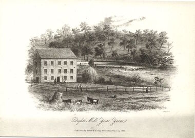
Print, Dight's Mill, Yarra Yarra
"In 1839 John Dight purchased Melbourne block 88, which included 26 acres of land along the Yarra River for £481 at the Port Phillip land sales held in Sydney. Dight was already in the business of flour milling and had a mill near Campbell Town in New South Wales called ‘Ceres’. In April 1840, he notified his customers through The Sydney Herald that he was leaving to go to Port Phillip. The first steam powered flour mill was constructed in Melbourne in 1841. Dight built his water powered mill, soon after, from bricks bought over from Tasmania. Dight used the river to power his mill: Water flowed along an inlet channel to turn an undershot water wheel. In order to regulate flow or to ensure flow for times when river levels were low, Dight constructed a rough stone weir. " (https://www.melbournewater.com.au/whatwedo/projectsaroundmelbourne/Documents/A_Short_History_of_Dights_Falls_Fact_Sheet.pdf) This work forms part of the collection assembled by the historian Dorothy Rogers, that was donated to the Kew Historical Society by her son John Rogers in 2015. The manuscripts, photographs, maps, and documents were sourced by her from both family and local collections or produced as references for her print publications. Many were directly used by Rogers in writing ‘Lovely Old Homes of Kew’ (1961) and 'A History of Kew' (1973), or the numerous articles on local history that she produced for suburban newspapers. Most of the photographs in the collection include detailed annotations in her hand. The Rogers Collection provides a comprehensive insight into the working habits of a historian in the 1960s and 1970s. Together it forms the largest privately-donated collection within the archives of the Kew Historical Society.An engraving of Dight's Mill on the Yarra. The image was originally published in Sands & Kenny, Melbourne & Sydney. Dorothy Rogers reproduced the print in 'A History of Kew' (1973). It faces page 8.Published by Sands & Kenny, Melbourne & Sydney, 1856dight's mill, dorothy rogers, dight's falls, yarra river, kew, john dight -
 Kew Historical Society Inc
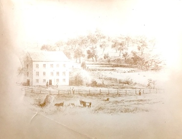
Print, Sands & Kenny, Dights Mill, 1856
"In 1839 John Dight purchased Melbourne block 88, which included 26 acres of land along the Yarra River for £481 at the Port Phillip land sales held in Sydney. Dight was already in the business of flour milling and had a mill near Campbell Town in New South Wales called ‘Ceres’. In April 1840, he notified his customers through The Sydney Herald that he was leaving to go to Port Phillip. The first steam powered flour mill was constructed in Melbourne in 1841. Dight built his water powered mill, soon after, from bricks bought over from Tasmania. Dight used the river to power his mill: Water flowed along an inlet channel to turn an undershot water wheel. In order to regulate flow or to ensure flow for times when river levels were low, Dight constructed a rough stone weir." (Melbourne Water)Dights Mill. Reproduction of a book plate from an original wood engraving, showing Dights Mill and Falls on the River Yarra. The image was originally published in Sands & Kenny, Melbourne & Sydney.Annotation on reverse: "Dights Flour".dights mill, yarra river -
 Surrey Hills Historical Society Collection
Photograph, St George's Church of England, Mont Albert working bee, early 1923 (1), 1923
The foundation stone for St George's Church of England, Mont Albert was laid in 1886 on land donated by Edward Dyer and the first service was preached in January 1887. From 1904 until 1907 it was known as Holy Trinity, Surrey Hills. The original church was weatherboard and replaced by a brick one in the Gothic Revival style which was designed by local architect George J V Blackburne, who also designed the Wesleyan School at Surrey Hills. The building was partly funded by donations, profits from a bazaar and concert, and other people donated furnishings. The church had boundaries along Mont Albert Road and St Georges Road. In 1998 the Church was sold and converted into a complex of units. Its current address is 19 St Georges Avenue, Mont Albert. Norman Carter took many photos of Surrey Hills and Mont Albert from the 1920s, in particular of events and activities associated with the Church of England.Black and white photo of 4 men at a working bee in the grounds of St George's Anglican Church in Mont Albert. Two men are on a scaffold working on the weatherboards of the church; the other two are working on fencing. One boundary is marked with a paling fence; the other has a section of picket fencing and a large open section with no fencing. There is a mature eucalyptus tree in front of the church; others are beyond the paling boundary fence. The church itself is a simply constructed weatherboard building.churches, holy trinity church, anglican church, st george's anglican church, working bees, norman brodley carter -
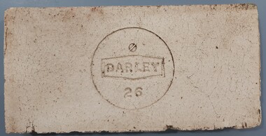 Bacchus Marsh & District Historical Society
Ceramic, Tile manufactured by Darley Firebrick Company
The manufacture of firebricks is believed to have begun in Bacchus Marsh in the 1880s when William Thomas Wittick in partnership with a Mr Ackers, and later a Mr Telford, quarried a rich deposit of fire clay at Darley. In 1902 financial assistance was provided by David Mitchell a significant businessman and contractor from Melbourne and the business then expanded and became a major supplier of refractories for gas works in Melbourne, with side lines in moulded fire bricks for foundries and smelting furnaces and complete kiln lines for potteries. The business traded under the name Darley Firebrick Company and later as Darley Refractories Ptd Ltd and was in business for over 100 years. The tile (aka refractory) described in this record was possibly produced for use in very high temperatures (in excess of 1,000°F [538°C]) encountered in modern manufacturing. More heat-resistant than metals, they are used to line the hot surfaces found inside many industrial processes. The date the tile was produced is unknown.Rectangle shaped ceramic tile'Darley 26' inscribed within a circledarley firebrick company, refractory materials, wittick family bacchus marsh, william thomas wittick 1857-1939, darley refractories ptd ltd -
 Department of Energy, Environment and Climate Action
Motorola "Bag Phone"
Motorola introduced the Bag Phone in 1988. These phones offered more durability and higher power output (up to 3 watts) than more conventional mobile phones of the time. Bag Phones were expensive to purchase and operate. They became available within the Department in the early 1990s but their use was very restricted to staff like fire communications duty officers. Senior regional managers also had bag phones. Bag Phones were also bulky and heavy and were often known as "The Brick". The 12 volt sealed lead-acid rechargeable battery provided up to 2.5 hours of talk time and 48 hours of standby time. They were replaced from the mid 1990s by smaller, analogue flip-phones with lighter Nicad batteries manufactured by companies like Nokia. The mobile phone network was patchy in country Victoria where two main telecommunications companies operated - Telstra and Optus.Motorola Bag Phone with handsetOptus 018 594 510 No battery Includes handset, aerial and 12 volt car-charger jack in vinyl bagforests commission victoria (fcv), communications -
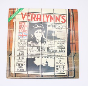 Shepparton RSL Sub Branch
Case, Vinyl Record, Hits of the War Years, 1985
Vera Lynn was a popular artist during the Second World War, known for her wholesome and romantic songs. This record was released on the 40th anniversary of the end of the Second World War and contains twenty songs that were popular during the period, especially with serving troops. Vera Lynn was supposedly fondly referred to as the "Forces' Sweetheart." The record contains the following songs: SIDE ONE 1. (There'll be Bluebirds over) The White Cliffs of Dover 2. Harbour Lights 3. As Time Goes By 4. Beautiful Isle of Somewhere 5. Auf Wiederseh'n Sweetheart 6. Faraway Places 7. Little Sir Echo 8. Mexican Rose 9. A Nightingale Sang In Berkeley Square 10. Jealousy SIDE TWO 1. It's a Lovely Day To-morrow 2. The Bells of St. Mary's 3. A Little Rain Must Fall 4. The Anniversary Waltz 5. Yours 6. When I Grow Too Old To Dream 7. It's A Sin to Tell A Lie 8. When The Lights Go On Again 9. Drifting And Dreaming 10. We'll Meet AgainThough not rare, as a mass produced product, this record is representative of the music that was well-known during the 1940s both on the home front and by serving troops. Its release as an anniversary edition speaks to the enduring memory of the period and for some community members who lived through the Second World War, has strong social significance and ability to recall memories of the wartime period. Glossy square-shaped card sleeve printed in colour with combination of text and black and white photographs arranged as though a newspaper page. From top left corner: green stripe, red album title, union jack, photograph of a young servicewoman, photograph of the Cliffs of Dover, photograph of St Mary's and various song titles in various serif fonts. Newspaper-style page set behind metal square fencing upon brick fence, simulating a newspaper being sold. Reverse features pastel-toned photograph of Vera Lynn, with smaller collage-style image of the newspaper-style text on front, below which are song titles for Side One and Side Two in a numbered list. vera lynn, music, wartime, second world war, world war ii, world war 2, musicians, anniversary -
Federation University Historical Collection
Document, Graeme Tyrrell, Overview for the Development of Gardens Lydiard Street Campus, 1988, 01/12/1988
The report was prepared by Graeme Tyrrell, headgroundsman/Gardener at the Ballarat School of Mines (SMB) for Bob Feary, Manager of Facilities at SMB. The report was designed to present a broad cover of current plans for specific sites at the Lydiard Street campus.Seven page report on the development of the Ballarat School of Mines Gardens, including the Motor Mechanics Portable, Hickman Street (now demolished); Recreation Building (now demolished), E.P.U.Y Building, Hickman Street, vacant block behind creche (now site of UBTec building); Creche, Grant Street (now demolished); Former Courthouse building, Grant Street terrace, Brick Court yard, conifer beds lining Lydiard Street, Herb Garden above M.B. John Building, Terrraced area above Ballarat School of Mines Botanical Garden (referred to as Von Mueller garden). The report includes a campus plan. The report is copied onto white paper and is stapled at the top left corner. ballarat school of mines botanical gardens, ballarat school of mines, bob feary, graeme tyrrell, gardens, ballarat school of mines campus, smb campus -
 Bendigo Historical Society Inc.
Photograph - T C WATTS & SON COLLECTION: CNR HARGREAVES & CHAPEL STREETS, 1927
BHS CollectionBlack and white photograph mounted on rectangular grey board. House, C.G.I. roof, finials to decorated gable ends, 3 brick chimneys w/decorated white capitals. Verandah has gable over front entrance, bowed corner window under verandah posts w/case iron lace above. Roughcast archway surrounds window under R.H. gable, two arched windows. R.H. rear of house. Wooden Fence pickets w/figured tops, capitals to gate posts, decorative front gate, hedge is clipped in harmony with fence tops. Cnr Hargreaves & Chapel Streets. Written on envelope: TC. Watts & Son, Cr Hargreaves and Chapel St. £1600.F.A. Jeffree, Photo, Bendigoplace, building, residential, chapel street, hargreaves street -
 Bendigo Historical Society Inc.
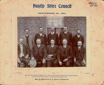
Photograph - HUNTLY SHIRE COUNCIL, 1911
Black and white photograph taken outside in front of a brick building. Five men standing behind five men seated (see 'Inscriptions'). Mounted on fawn board. Inscriptions' Front 'MP114, GP46', 'Huntly Shire Council, September 14, 1911', 'Photo WH Robinson, Bendigo'. Back row: Crs Matthews, E Buckland, Mr A Fulton (Shire Secretary and Engineer), Crs Coughlin, Sullivan'. Front row: Crs Peatling, Walter, G Simmie (President),Sharkey, Carr', 'With the President's (Cr G Simmie), compliments'. On back RHSV Stamp 'WM H Robinson, Photographer, Mundy St, Bendigo', 'Bendigo Historical Society (Inc.) typed on white paper, glued to board.WM H Robinson, Mundy St Bendigoperson, group, huntly shire council -
 Bendigo Historical Society Inc.
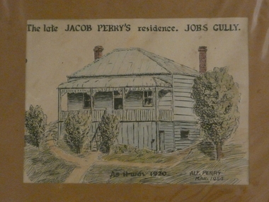
Painting - JACOB PERRY'S RESIDENCE JOBS GULLY
Watercolour and black pen, painted by Alf Perry 1954. Painting shows elevated weather board house, two brick chimneys. Stairs up to front verandah. Written across the top :'The late Jacob Perry's residence. Jobs Gully.Written on bottom of artwork ' As it was 1920, Alf Perry 1954. Written by Alf Perry, in pencil on the back, is the following: ' Drawn from the house in March 1954 but as I knew it in 1920. A verandah is built at the right hand side of the house now. The window below floor level at the right let in light to the little workshop my grandfather used. I used to go up and make (?) little bone knives and forks out of ordinary bones. Alf Perry 1954'.house, private, jacob perry, jobs gully -
 Bendigo Historical Society Inc.
Photograph - LONG GULLY HISTORY GROUP COLLECTION: LONG GULLY SCHOOL PHOTO 1920'S
Copy of a black and white Long Gully School 2120 Photo Grades 1 -11 from the 1920's. Children are sitting or standing outside a brick building. Two children in the front row are holding up a blackboard with the name of the school and grades written on it. The known names are written under the photo. They are: MItchell, Connor, M Penno, Boyd, G Harvey, R Crossman, Birchmore, M Saunders, M Ross, S Rowe, Bux, T Eva, R Salter, J Harvey, J Cox, J Betts, M Smart, B Bryar, Thorn, Pithie, F Birchnall, M Field, K Landy and E Bassett. The year and the name Joyce Cox is written on the paper.bendigo, history, long gully history group, the long gully history group - long gully school photo 1920's, mitchell, connor, m penno, boyd, g harvey, r crossman, birchmore, m saunders, m ross, s rowe, bux, t eva, r salter, j harvey, j cox, j betts, m smart, b bryar, thorn, pithie, f birchnall, m field, k landy, e bassett, joyce cox -
 Bendigo Historical Society Inc.
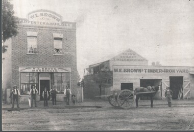
Photograph - HARRY BIGGS COLLECTION: W E BROWN CARPENTER, BUILDER, IRONMONGER
Photograph. Harry Biggs Collection. 2 photos. (1 mounted on card) of W. E. Brown's business. On the left is a brick building with W. E. Brown Carpenter & Builder. Below this are two windows with two people in each looking out. Below this residence is the shop with the sign above the door W. E. Brown Ironmonger Brush wear & Paper Hangings. Standing in front of this are 4 men & a little boy. Beside this building is a gate & lane way, then a wooden shed with the sign W. E Browns Timber & Iron Yard. Above that sign is a further sign - W. E. Brown Builder Timber Merchant. In front of this is a horse & cart with some timber in it & a worker beside the horse.place, building, commercial, harry biggs collection, w. e. brown -
 Kew Historical Society Inc
Plan - Subdivision Plan, Bella Vista Estate, 1929
Pru Sanderson, in her groundbreaking ‘City of Kew Urban Conservation Study : Volume 2 - Development History’ (1988), summarised the periods of urban development and subdivisions of land in Kew. The periods that she identified included 1845-1880, 1880-1893, 1893-1921, 1921-1933, 1933-1943, and Post-War Development. These periods were selected as they represented periods of rapid growth or decline in urban development. An obvious starting point for Sanderson’s groupings involved population growth and the associated economic cycles. These cycles also highlighted urban expansion onto land that was predominantly rural, although in other cases it represented the decline and breakup of large estates. A number of the plans in the Kew Historical Society’s collection can also be found in other collections, such as those of the State Library of Victoria and the Boroondara Library Service. A number are however unique to the collection.The Kew Historical Society collection includes almost 100 subdivision plans pertaining to suburbs of the City of Melbourne. Most of these are of Kew, Kew East or Studley Park, although a smaller number are plans of Camberwell, Deepdene, Balwyn and Hawthorn. It is believed that the majority of the plans were gifted to the Society by persons connected with the real estate firm - J. R. Mathers and McMillan, 136 Cotham Road, Kew. The Plans in the collection are rarely in pristine form, being working plans on which the agent would write notes and record lots sold and the prices of these. The subdivision plans are historically significant examples of the growth of urban Melbourne from the beginning of the 20th Century up until the 1980s. A number of the plans are double-sided and often include a photograph on the reverse. A number of the latter are by noted photographers such as J.E. Barnes.Bella Vista (later ‘Malinda’) was a large Federation house designed by the architect Robert Haddon for Abel Hoadley. The house was built in 1902 and occupied the eastern corner of Thomas Street and Cotham Road. It was a single-storey, red brick house, set back from the road, featuring a central tower topped by a pagoda-like red terra cotta roof, on top of which was perched a very large terra cotta dragon. The Bella Vista subdivision of 1929 included Hoadley’s house as well as nine allotments facing Cotham Road and Alfred and Thomas Streets. In 1941, the land on which Hoadley’s house stood was to be further subdivided. Bella Vista is believed to have lasted until it was demolished in the 1980s.subdivision plans - kew, bella vista estate -
 Bacchus Marsh & District Historical Society
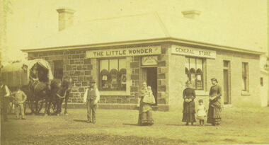
Photograph, Alford's Little Wonder Store Bacchus Marsh 1883
The Little Wonder Store was built in 1883 from materials of the demolished Maddingley School. It was located on the corner of Grant Street and Labilliere Street. In 1886 James Alford obtained a licence to conduct the Railway Hotel and General Store there. A second storey was added later and the building continued to operate as the Railway Hotel. It was destroyed by fire in 1998. The photo also shows the covered wagon of a travelling salesman, who were known as ‘hawkers’, who were significant in the supply of goods and news to outlying towns and districts before the development of road and rail networks. Small sepia 'carte de viste' style unframed photograph on card with gold border framing photograph. Housed in the Jeremeas Family Album which contains photographs of Bacchus Marsh and District in 1883 by the photographers Stevenson and McNicoll. The photo shows a single-storey building of bluestone and brick with two signs on the front and side, the front sign reading “THE LITTLE WONDER” and the side sign “GENERAL STORE”. Above the door is a sign with the name ‘James Alford’. The windows display the merchandise of the store. Outside the store is a travelling salesman’s cart pulled by two horses. The salesman sits in the cart ready to drive off. Standing along the street outside the store are three men, three women and two young children.Printed On the front: Stevenson & McNicoll. Photo. 108 Elizabeth St. Melbourne. COPIES CAN BE OBTAINED AT ANY TIME. On the back: LIGHT & TRUTH inscribed on a banner surmounted by a representation of the rising sun. Copies of this Portrait can be had at any time by sending the Name and Post Office Money Order or Stamps for the amount of order to STEVENSON & McNICOLL LATE BENSON & STEVENSON, Photographers. 108 Elizabeth Street, MELBOURNE. stevenson and mcnicoll 1883 photographs of bacchus marsh and district, shops bacchus marsh, general stores bacchus marsh vic., hawkers, hotels bacchus marsh -
 Melbourne Tram Museum
Drawing, Melbourne & Metropolitan Tramways Board (MMTB), "Detail of land leased to Alfred Kefford Pty Ltd", undated
Photocopy of a drawing or plan on an A4 sheet, titled "Detail of land leased to Alfred Kefford Pty Ltd" and the back of the former MMTB Office building in Victoria Parade Fitzroy. Gives the block dimension, streets, a location of a workshop and the brick office building. The Young St sub-station was excluded. Gives details of the fences. Plan undated. Rod Atkins advised 29/7/19 that Alfred Kefford nee Pty Ltd. resided at no 17 Young Street on corner of Duke Street just several doors further up Young Street on the same side. All I know so far is they were into some form of delivery type transport - i.e.. carrier.trams, tramways, mmtb, buses, lease agreement, victoria parade, young st, substation -
 Eltham District Historical Society Inc
Photograph, Monash Bridge, Arthurs Creek Road, Hurstbridge, Eltham Heritage Tour, 24 May 1992, 24/05/1992
ELTHAM HERITAGE TOUR The Society excursion on 24th May 1992 was arranged by David Bick, leader of the team carrying out the Shire's heritage study. David selected a number of sites or buildings identified in the study, some of them lesser known components of the Shire's heritage. The tour commenced at the Eltham Shire Office at 10.00 am. Travel was by private car and mini-bus with stops at about twelve locations for commentary by David.It included a short walk in Hurstbridge and lunch at Kinglake. Highlights of the tour included: - 10 am Leave from Shire Offices - 3 Important Trees - A Physical Link to Eltham's First Settlers - Toorak Mansion Gates - A Surviving Farm House - An Intact Circa 1900 Main Street - First Settlers - Gold Miners, and Timber-getters - An Early Hotel - A Pioneering Homestead - Changing Eltham Shire - 20th Century - 4 pm Afternoon Tea and Finish Tour Extract from ELTHAM CULTURAL HERITAGE TOUR (Newsletter No. 85, July 1992, by Bettina Woodburn) "On the Arthurs Creek Road is a bridge designed by Monash, which we admired before walking across the little park with a mud-brick and timber shelter, to the Hurst family graveyard. There are two marked graves, one, Henry who was shot by Burke the bushranger and a cairn has a plaque listing others buried here from 1866 onwards. Burke was captured and tied to the wheel of a dray under the eucalypt near the waterhose/standpipe. Close by the kindergarten, at this place are three trees on the National Trust Register, a Canary Island pine, a Canadian cedar and probably a spruce. Radiata pines and a thick bolled peppercorn surround the little cemetery. Continuing along Main Street we notice elm trees planted as a war memorial, then on the left a 1930 timber house, a 1910 store and residence, resplendent with wrought iron trim, a double fronted Hardware Store and cypresses on the back alignment of a new vacant block. On the right side of the street is a less interesting attempt at an 'in character' shop. Further on are more early homes, one tucked away at the rear with two tall palms by the front steps. Another curiosity is a rounded veranda corner and there are more galvanised iron sheds or garages, before a mud-brick Dentist's Surgery. Beyond the round-a-about is St Peters Church, of mud-brick construction shared by Catholic and Anglican parishioners, overlooking the river flood plain. Leaving Hurstbridge on the Kinglake Road, we ate our picnic lunch beside the communication tower and enjoyed views of Melbourne, Yan Yean Reservoir and the distant Dandenongs beyond the spreading suburbs. Next we drove to the North West boundary of the Shire at Masons Falls Road towards Whittlesea. On the way to the North East Boundary we passed St Peters, a yellow wooden Church with a Tudor Archway; built in the early 1920's in the style of the 1860's. From the Healesville-Kinglake road the rolling hills had European aspects, the hedged fields and chestnut trees. Then it was back down the Hurstbridge Road through 'Aussie' bush of towering gums, with bracken and scrubby understorey, the Kinglake National Park, before more open country with deciduous trees planted in line, and a creek lined with willows."Record of the Society's history and activities and highlighting various aspects of the Heritage Study undertaken by David Bick used to create the future heritage overlay for the Shire of Eltham and later Nillumbik Shire.Roll of 35mm colour negative film, 4 stripsKodak Gold 100 5095shire of eltham historical society, activities, heritage tour, hurstbridge, monash bridge, arthurs creek road -
 Bendigo Historical Society Inc.
Photograph - HILDA HILL COLLECTION: BLACK AND WHITE PHOTOS, 1920
Hilda Hill Collection. Black & White Family Photos Total of 5. The 3 photos taken in 1920 depict family gathering at Durvol Kyneton in September, the gentlemen of the family at 'The Ranch' ?Eppalock in November and Mona nursing baby at Kilmore on December 19th. Stiffy & Mo Both dressed in white shirts and dark trousers seated on the ground in front of a white brick building, to the left there is a plant growing along a frames work attached to the verandah, window in house wall, Frank dressed in a school suit which has embossing on the pocket, he is standing in front of a trellis covered in shrubbery, both hands are in his pockets. Four men and a boy, all dressed in dark suits white shirts and dark ties,man in middle has his right hand in his pocket, and the boy has his tie outside of the coat, the four men are all wearing hats, The Ranch November 1920. Mona at Kilmuir December 19th 1920, Mona is wearing a large hat and wearing a dark dress and nursing a baby dressed in white, right background is a white door. Rough, Doreen Vin, Tom Durvol September 1920, Doreen is wearing a white blouse dark skirt and dark stockings with black shoes, Vin wears a dark suit white shirt and dark tie, Tom is wearing a white shirt and dark shorts with braces, also dark socks and shoes, background is steps upon which these folk are sitting and is part of the larger house made of brick .Hilda Hill Personal Collectionaustralia, history, victoria -
 Kew Historical Society Inc
Plan, Melbourne and Metropolitan Board of Works, Borough of Kew : Detail Plan No.1580, 1904
The Melbourne and Metropolitan Board of Works (MMBW) plans were produced from the 1890s to the 1950s. They were crucial to the design and development of Melbourne's sewerage and drainage system. The plans, at a scale of 40 feet to 1 inch (1:480), provide a detailed historical record of Melbourne streetscapes and environmental features. Each plan covers one or two street blocks (roughly six streets), showing details of buildings, including garden layouts and ownership boundaries, and features such as laneways, drains, bridges, parks, municipal boundaries and other prominent landmarks as they existed at the time each plan was produced. (Source: State Library of Victoria)This plan forms part of a large group of MMBW plans and maps that was donated to the Society by the Mr Poulter, City Engineer of the City of Kew in 1989. Within this collection, thirty-five hand-coloured plans, backed with linen, are of statewide significance as they include annotations that provide details of construction materials used in buildings in the first decade of the 20th century as well as additional information about land ownership and usage. The copies in the Public Record Office Victoria and the State Library of Victoria are monochrome versions which do not denote building materials so that the maps in this collection are invaluable and unique tools for researchers and heritage consultants. A number of the plans are not held in the collection of the State Library of Victoria so they have the additional attribute of rarity.Original survey plan, issued by the MMBW to a contractor with responsibility for constructing sewers in the area identified on the plan within the Borough of Kew. The plan was at some stage hand-coloured, possibly by the contractor, but more likely by officers working in the Engineering Department of the Borough and later Town, then City of Kew. The hand-coloured sections of buildings on the plan were used to denote masonry or brick constructions (pink), weatherboard constructions (yellow), and public buildings (grey). The area represented in this detail plan has undergone significant change during the 20th century. The widening of High Street in the 1930s and 1950s involved the shops on the south side of High Street being demolished and later rebuilt to fit the widened street. Another significant loss was the mansion ‘Drayton’ fronting Wellington Street, owned at this stage by Susannah Fenton. Her family name would later to be given to Fenton Way, which was to be built over the grounds of the house following its demolition. The plan of the garden is particularly interesting, containing a batten dome fronting Wellington Street, an ornamental pond, a fountain and a brick and glass conservatory. The notes by the plumbing contractor on this plan are particularly detailed. Pink borders delineate the ownership of the varying parcels of land. Some of the better known owners listed include the real estate agent Cr. Henry de Castres Kellett (bt) and John Padbury, the funeral director. This particular plan provides a clear view of the configuration of the Kew Junction in 1903 and the commercial buildings that surrounded it.melbourne and metropolitan board of works, detail plans, maps - borough of kew, mmbw 1580, cartography -
 Kew Historical Society Inc
Plan, Melbourne & Metropolitan Board of Works : Borough of Kew : Detail Plan No.1582, 1904
The Melbourne and Metropolitan Board of Works (MMBW) plans were produced from the 1890s to the 1950s. They were crucial to the design and development of Melbourne's sewerage and drainage system. The plans, at a scale of 40 feet to 1 inch (1:480), provide a detailed historical record of Melbourne streetscapes and environmental features. Each plan covers one or two street blocks (roughly six streets), showing details of buildings, including garden layouts and ownership boundaries, and features such as laneways, drains, bridges, parks, municipal boundaries and other prominent landmarks as they existed at the time each plan was produced. (Source: State Library of Victoria)This plan forms part of a large group of MMBW plans and maps that was donated to the Society by the Mr Poulter, City Engineer of the City of Kew in 1989. Within this collection, thirty-five hand-coloured plans, backed with linen, are of statewide significance as they include annotations that provide details of construction materials used in buildings in the first decade of the 20th century as well as additional information about land ownership and usage. The copies in the Public Record Office Victoria and the State Library of Victoria are monochrome versions which do not denote building materials so that the maps in this collection are invaluable and unique tools for researchers and heritage consultants. A number of the plans are not held in the collection of the State Library of Victoria so they have the additional attribute of rarity.Original survey plan, issued by the MMBW to a contractor with responsibility for constructing sewers in the area identified on the plan within the Borough of Kew. The plan was at some stage hand-coloured, possibly by the contractor, but more likely by officers working in the Engineering Department of the Borough and later Town, then City of Kew. The hand-coloured sections of buildings on the plan were used to denote masonry or brick constructions (pink), weatherboard constructions (yellow), and public buildings (grey). Public buildings, coloured grey on the Plan 1582 include the police station and post office, churches and schools. The earliest church school, Common School No.356 was located at the rear of the Congregational Church in Peel Street. It was constructed in 1859. The first buildings of Kew Primary School No.1075 on the other side of Peel Street were constructed in 1871. The school in 1903 only occupied a small fraction of its current site. In 1903, where the rear playground is now located, were two weatherboard and one brick villa. Trinity Grammar School was founded in 1902 and opened in the Parish Hall at the rear of Holy Trinity Anglican Church. It was not to move to its current site until 1906. The outline of the building housing the Kew Fire Brigade in the centre of the north side of Walton Street is shown but not named on the plan. Further down Pakington Street stood the two-storey Italianate mansion ‘Overton’. The home of Stanford Chapman, it was to be featured in the Imperial Institute series of bromide photographs of Victoria, Vol. 1: Homes and scenery. It was later to become a boarding house before it was later demolished.melbourne and metropolitan board of works, detail plans, maps - borough of kew, mmbw 1582, cartography