Showing 123958 items matching "main-road"
-
 Kew Historical Society Inc
Photograph, Burke Road Bridge, 1930s
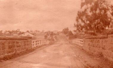
Without bridges, Kew remained cut off from the City of Melbourne, only being accessible by Punt. Private and public bridges were constructed from the 1850s, beginning with the Hawthorn Bridge linking Bridge and Burwood Roads. A bridge across the Yarra at Burke Road was created as early as 1873. Since that first wooden bridge, a number of later bridges, typically on concrete pylons have been built, in 1926 and again during the 1970s.Sepia, faded photograph of the Burke Road Bridge linking East Kew and Ivanhoe. The previous bridge, constructed in 1926 was submerged beneath the flood waters in the 1934 mega-flood of the Yarra.burke road bridge (kew), bridges -- river yarra -
 Greensborough Historical Society
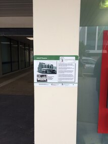
Photograph - Digital Image, Chris Foster, Ashril Theatre (Main Street Plaques Project), 17/05/2018
In 2018, Greensborough Historical Society placed plaques in the Main Street area of Greensborough. In this photograph, GHS member Chris Foster has photographed the installation of the Ashril Theatre plaque on Main Street Greensborough. The Main Street Plaques Project placed historical information about original Greensborough buildings as close to the original site as possible. Further information available on the GHS website. The Plaques were made possible through a Greensborough RSL Grant.Digital copy of colour photograph.main street plaques project, main street greensborough, ashril theatre -
 Greensborough Historical Society
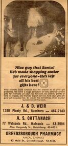
Advertisement - Digital image, Diamond Valley News, Greensborough Pharmacy, 1967, 28/11/1967
Advertisement in the local paper for Greensborough Pharmacy, Main Street Greensborough 1967. Also associated with J & D Weir of Plenty Road Bundoora and A.S. Cattanach of Watsonia Road Watsonia.Part of a collection of historic advertisements from local newspapers, showing local businesses from the mid 20th century.Digital copy of newspaper advertisement.watsonia road, pharmacies, greensborough pharmacy, weir pharmacy, cattanach pharmacy -
 Greensborough Historical Society
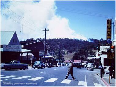
Photograph - Digital Image, Paul de Sauty, Main Street Greensborough, 1960s, 1960s
Photograph of Main Street Greensborough, 1960s.Digital copy of colour photograph.paul de sauty, main street greensborough -
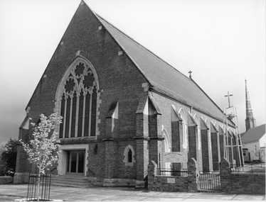
 Stawell Historical Society Inc
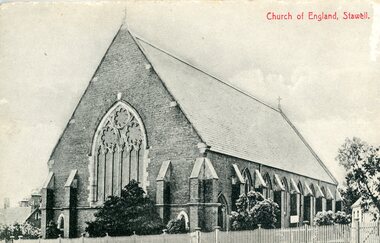
Photograph, Anglican Church in Main Street Stawell
Anglican Church Main Street Stawellstawell -
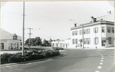 Stawell Historical Society Inc
Photograph, Main Street and Patrick Street corner in Stawell 1996
Corner of Main and Patrick Streets 1996stawell -
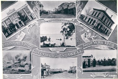 Stawell Historical Society Inc
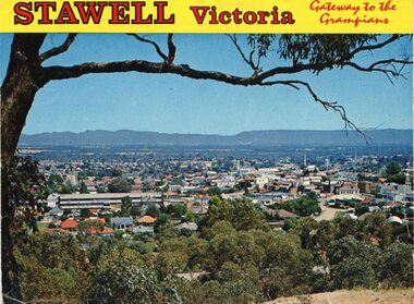
Photograph, Main Street and Buildings in Stawell 1907 -- Postcard
Main Street and Buildings Stawell 1907stawell -
 Stawell Historical Society Inc
Photograph, Anglican Church in Main Street Stawell
Anglican Church Main Street Stawellbuildings -
 Stawell Historical Society Inc
Photograph, Main Street and Patrick Street corner in Stawell 1996
Corner of Main and Patrick Streets 1996stawell -
 Stawell Historical Society Inc
Postcard, Front Cover & the Bull and Mouth Hotel in Main Street Stawell -- 2 Photos -- Postcards -- Coloured
Bull and Mouth Hotel Main Streetstawell streetscape -
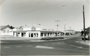
 Stawell Historical Society Inc
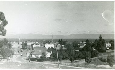
Photograph, Upper Main Street Stawell c1940
Upper Main Street Stawell c1940stawell -
 Stawell Historical Society Inc
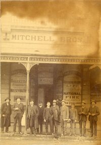
Photograph, Mitchell Brothers' shop in Main Street Stawell
Mitchell Bros. Shop. Main Streetstawell -
 Ringwood and District Historical Society
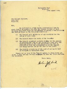
Letter, To Borough Engineer from Arthur Blood confirming gift of land adjoining Bowling Green for road-making purposes
1929 saw the establishment of the Ringwood Bowls Club initially located on the land now occupied by the Eastland Shopping Centre. It moved to its current location in Loughnan Road, Ringwood in 1997.Typed letter to Ringwood Borough Engineer from Arthur Blood confirming gift of land adjoining Bowling Green for road-making purposes. Dated 10th August 1930.city of ringwood bowls club, ringwood bowling club, ringwood bowls club, lawn bowls, bowling -
 Kew Historical Society Inc
Plan, Survey Plan, Park Hill Road, Kew, 1880-1890
The streets identified on the survey plan - Cotham Road, Park Hill Road East, Park Hill Road West in Kew were each gazetted by the Victorian Government in 1865. The hand-coloured survey plan was completed by Holland Loxton, Town Clerk and Surveyor of the Borough of Kew from 1866. The unnamed survey plan includes names of land owners in addition to measurements (2 chains to 1 inch) and streets. Named owners include Webster, Payne and Francom which will enable us to narrow down the creation date of the survey.Handdrawn survey plan by a former surveyor and town clerk of KewHand drawn and coloured survey plan created by Holland Loxton, Surveyor and Town Clerk of Kew, showing land owned by Payne in Park Hill Road, Kew. The plan includes street names, land measurements and land owners.surveys - kew, maps - kew, holland loxton, park hill road - kew, holland loxton -- surveyor, survey plans -- parkhill road -- kew (vic.) -
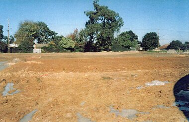 Ringwood and District Historical Society
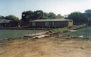
Photograph, Ringwood Bowls Club- Construction of new Bowls Club at corner of Laughnan Road and Warrandyte Road, 1996
Coloured photographPhotograph shows earthworks for greens at new Bowls Club at Laughnan Road. -
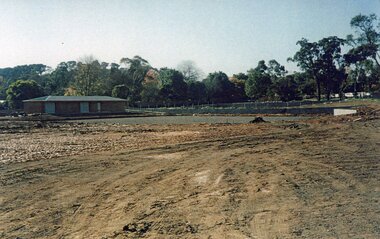 Ringwood and District Historical Society
Photograph, Ringwood Bowls Club- Construction of new Bowls Club at corner of Laughnan Road and Warrandyte Road, 1996
Coloured photographPhotograph shows earthworks for greens at new Bowls Club at Laughnan Road. -
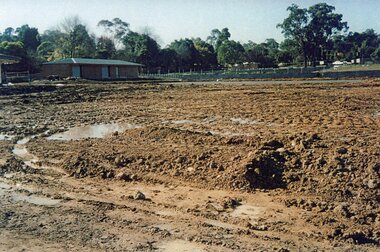 Ringwood and District Historical Society
Photograph, Ringwood Bowls Club- Construction of new Bowls Club at corner of Laughnan Road and Warrandyte Road, 1996
Coloured photographPhotograph shows earthworks for greens at new Bowls Club at Laughnan Road. -
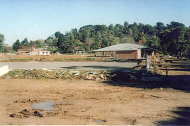 Ringwood and District Historical Society
Photograph, Ringwood Bowls Club- Construction of new Bowls Club at corner of Laughnan Road and Warrandyte Road, 1996
Coloured photographPhotograph shows earthworks for greens at new Bowls Club at Laughnan Road. -
 Ringwood and District Historical Society
Photograph, Ringwood Bowls Club- Construction of new Bowls Club at corner of Laughnan Road and Warrandyte Road, 1996
Coloured photographPhotograph shows earthworks for greens at new Bowls Club at Laughnan Road. -
 Eltham District Historical Society Inc
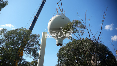
Photograph, Demolition of water tower at 51 Cassells Road, Research, 6 April 2017, 6/4/2017
"The water storage tank (the ‘golf ball’ tower) was located in Cassells Road, and for many years it played an important role in supplying the Research and Eltham communities with drinking water. However, due to prior upgrades of water supply infrastructure in the area, these communities are receiving their water supply in a more reliable way. The storage tank was no longer operating and as it no longer served a purpose, the time had come for it to be removed. Decommissioning works occurred between November 2016 and January 2017, and the tower was removed in March 2017." Source: Yarra Valley Water Eltham Water Project onlineDigital files only (17 jpg and one two second MP4 files)cassells road, demolition, research (vic.), water tower -
 Glen Eira Historical Society
Album - Album page, St Stephen's Presbyterian Church, Balaclava Road, Circa 1972
This photograph is part of the Caulfield Historical Album 1972. This album was created in approximately 1972 as part of a project by the Caulfield Historical Society to assist in identifying buildings worthy of preservation. The album is related to a Survey the Caulfield Historical Society developed in collaboration with the National Trust of Australia (Victoria) and Caulfield City Council to identify historic buildings within the City of Caulfield that warranted the protection of a National Trust Classification. Principal photographer thought to be Trevor Hart, member of Caulfield Historical Society. Most photographs were taken between 1966-1972 with a small number of photographs being older and from unknown sources. All photographs are black and white except where stated, with 386 photographs over 198 pages. From: Glen Eira Heritage Management Plan (1996) by Andrew Ward and Associates In 1905, the land was vacant in Balaclava Road, north side, from Kooyong Road east to the right of way, except for one house. A block of this land was acquired by the Presbyterian community and a timber church erected there in 1910. In time, a larger church was required. After several years of fund raising led by George Kinross, a new red brick St Stephen's church was built in 1926 to the design of architects Haddon and Henderson. George Currie was the builder and the cost of construction was £5,100.From: Glen Eira Heritage Management Plan (1996) by Andrew Ward and Associates: St Stephens has architectural importance as a noteworthy example of a Gothic Transitional design in the Arts and Crafts eclectic manner (see Stylistic Typology in National Trust's Historic Church's Study}. The facade treatment successfully combines Christian symbols with Gothic forms in the Arts and Crafts mode (comparable with Haddon's Presbyterian Church, Malvern (1906) and Haddon and Henderson's Oakleigh Church (1928). It is locally important as an example of Robert Haddon's work in Caulfield, where he also lived (4 Glenferrie St q.v.).Page 25 of Photograph Album - four black and white photographs of St Stephen's Presbyterian Church, with two photographs in landscape mode across the top showing information about who designed the building in one and showing the church name and year founded in the other; and two in portrait mode in the bottom section showing 2 different heavy wooden doors.Hand written: 25 [bottom left]trevor hart, caulfield north, balaclava road, george kinross, haddon and henderson, george currie, st stephen's, 1900's, 1920's, gothic transitional, christian symbols, arts and crafts, robert haddon, stylistic typology, gothic, presbyterian church, architects, red brick, doors, memorials -
 Glen Eira Historical Society
Album - Album page, St Stephen's Presbyterian Church, Balaclava Road, Circa 1972
This photograph is part of the Caulfield Historical Album 1972. This album was created in approximately 1972 as part of a project by the Caulfield Historical Society to assist in identifying buildings worthy of preservation. The album is related to a Survey the Caulfield Historical Society developed in collaboration with the National Trust of Australia (Victoria) and Caulfield City Council to identify historic buildings within the City of Caulfield that warranted the protection of a National Trust Classification. Principal photographer thought to be Trevor Hart, member of Caulfield Historical Society. Most photographs were taken between 1966-1972 with a small number of photographs being older and from unknown sources. All photographs are black and white except where stated, with 386 photographs over 198 pages. From: Glen Eira Heritage Management Plan (1996) by Andrew Ward and Associates In 1905, the land was vacant in Balaclava Road, north side, from Kooyong Road east to the right of way, except for one house. A block of this land was acquired by the Presbyterian community and a timber church erected there in 1910. In time, a larger church was required. After several years of fund raising led by George Kinross, a new red brick St Stephen's church was built in 1926 to the design of architects Haddon and Henderson. George Currie was the builder and the cost of construction was £5,100.From: Glen Eira Heritage Management Plan (1996) by Andrew Ward and Associates: St Stephens has architectural importance as a noteworthy example of a Gothic Transitional design in the Arts and Crafts eclectic manner (see Stylistic Typology in National Trust's Historic Church's Study}. The facade treatment successfully combines Christian symbols with Gothic forms in the Arts and Crafts mode (comparable with Haddon's Presbyterian Church, Malvern (1906) and Haddon and Henderson's Oakleigh Church (1928). It is locally important as an example of Robert Haddon's work in Caulfield, where he also lived (4 Glenferrie St q.v.).Page 27 of Photograph Album with one photograph of a drawing or perhaps a postcard of St Stephen's Presbyterian Church. It has a large block of formal writing in the bottom right corner which looks official.Hand written: 27 [bottom right]trevor hart, caulfield north, balaclava road, george kinross, haddon and henderson, george currie, st stephen's, 1900's, 1920's, gothic transitional, christian symbols, arts and crafts, robert haddon, stylistic typology, gothic, presbyterian church, architects, drawings -
 Surrey Hills Historical Society Collection
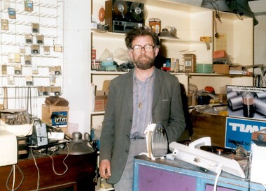
Photo, Henry Jamieson in his shop at 149 Union Road, Surrey Hills
Henry was a familiar persona in Union Road and around the Surrey Hills Neighbourhood Centre for decades. He lived all his life within 3 kilometres of his radio shop. Son of Catherine and ‘Mick’ Jamieson, Henry was born in 1927 in View Street, Surrey Hills and was educated at Box Hill Grammar School. His father died when he was young and Henry took a job as a technical assistant with the Commonwealth Film Unit. Film was a life-long interest and he became a longstanding member of CATHS (Cinema and Theatre Historical Society of Victoria). Henry also had a profound love of music which was reflected in his work and hobbies. He joined Adrian Knowles, who had started his radio shop at 149 Union Road in the 1940s, and trained at RMIT as a radio tradesman. In time Henry took over the business. When 3MBS established in Kew, Henry was an enthusiastic supporter and volunteer. For some years Henry and a co-producer presented a prime time Saturday evening programme 'Bach to Bernstein'; later his distinctive voice could be heard in the early morning time slot, 'Daybreak'. Henry was also a staunch supporter of the Surrey Hills Historical Society and served as its President for a number of years. Henry died in 2011. Colour photo of a bearded man inside a shop with an assortment of radio and electrical appliances and components.knowles radio, surrey hills neighbourhood centre, union road, surrey hills historical society, cinema and theatre historical society of victoria, 3mbs radio, henry jamieson, adrain knowles -
 Whitehorse Historical Society Inc.
Map, Deep Creek Road, Mitcham, c1975
Enlargement of aerial photograph of area bounded by Dalmar Road, Cray Road, Glenvale Road and Maroondah Highway, MitchamEnlargement of aerial photograph of area bounded by Dalmar Road, Cray Road, Glenvale Road and Maroondah Highway, MitchamEnlargement of aerial photograph of area bounded by Dalmar Road, Cray Road, Glenvale Road and Maroondah Highway, Mitchamcray road, donvale, glenvale road, donvale, maroondah highway, mitcham, dalmor road, mitcham, deep creek road, mitcham, aerial photographs -
Lakes Entrance Historical Society
Book, Road Design Manual, 1985
Road design manual for rural and urban roads other than freeways giving all aspects of road construction.road construction and maintenance -
 Greensborough Historical Society
Photograph - Digital Image, Main Street Greensborough c1910, 1910s
A view of Main Street Greensborough taken in the 1910s.Digital copy of black and white photograph.main street greensborough -
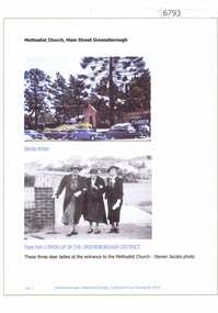 Greensborough Historical Society
Article and Photograph, Methodist Church, Main Street Greensborough, 2016_
Photographs of the Methodist Church Main Street Greensborough. This photograph and text was copied from a Facebook site. Members are people who lived in the Greensborough area and share their reminiscences of the area with others. The site is administered by a GHS member but is not officially affiliated with the Society. Any information is the opinion of the contributor. Photographs sourced from social media.greensborough methodist church -
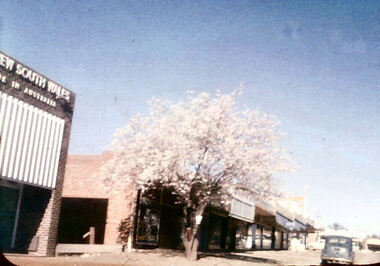 Greensborough Historical Society
Photograph - Digital Image, Main Street Greensborough, circa 1960, 1960s
View of Main Street Greensborough, circa 1960. Digital copy of colour photographmain street greensborough -
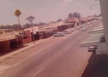 Greensborough Historical Society
Photograph - Digital image, Main Street Greensborough, 1960c
Photograph of Main Street Greensborough during the 1960s.Digital copy of colour photograph.main street greensborough -
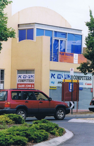 Greensborough Historical Society
Photograph - Digital image, Frank Solomon, Greensborough: Main Street and Grimshaw Street corner, 04/06/2010
Greensborough: Main Street and Grimshaw Street cornerDigital copy of colour photographmain street greensborough, grimshaw street greensborough