Showing 10531 items
matching land
-
 Bendigo Historical Society Inc.
Document - Letter book 1865
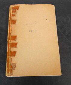
George Langford esq. was appointed to the land office at Echuca in 1865.Beige coloured book with sticky tape in binding. This cover has been placed over original cover. The book contains details of letters sent and received from various department and people. Most of the correspondence is signed by George Langford esq. The book has 152 pages in total of which 76 have been filled in. Possibly from Echuca.Letter book 1865 No.2 on inside cover and letter book 1865 in pen on front coverletters, 1865, george langford, land office -
 Ballarat and District Irish Association
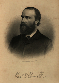
Image, Charles Parnell, c1864, 1864
Parnell was an Irish nationalist and statesman who led the fight for Irish Home Rule in the 1880s. Charles Stewart Parnell was born on 27 June 1846 in County Wicklow into a family of Anglo-Irish Protestant landowners. He studied at Cambridge University and was elected to parliament in 1875 as a member of the Home Rule League (later re-named by Parnell the Irish Parliamentary Party). His abilities soon became evident. In 1878, Parnell became an active opponent of the Irish land laws, believing their reform should be the first step on the road to Home Rule. In 1879, Parnell was elected president of the newly founded National Land League and the following year he visited the United States to gain both funds and support for land reform. In the 1880 election, he supported the Liberal leader William Gladstone, but when Gladstone's Land Act of 1881 fell short of expectations, he joined the opposition. By now he had become the accepted leader of the Irish nationalist movement. Parnell now encouraged boycott as a means of influencing landlords and land agents, and as a result he was sent to jail and the Land League was suppressed. From Kilmainham prison he called on Irish peasants to stop paying rent. In March 1882, he negotiated an agreement with Gladstone - the Kilmainham Treaty - in which he urged his followers to avoid violence. But this peaceful policy was severely challenged by the murder in May 1882 of two senior British officials in Phoenix Park in Dublin by members of an Irish terrorist group. Parnell condemned the murders. In 1886, Parnell joined with the Liberals to defeat Lord Salisbury's Conservative government. Gladstone became prime minister and introduced the first Irish Home Rule Bill. Parnell believed it was flawed but said he was prepared to vote for it. The Bill split the Liberal Party and was defeated in the House of Commons. Gladstone's government fell soon afterwards.(http://www.bbc.co.uk/history/historic_figures/parnell_charles.shtml, accessed 21 January 2014) The Irish National Land League (Irish: Conradh na Talún) was an Irish political organisation of the late 19th century which sought to help poor tenant farmers. Its primary aim was to abolish landlordism in Ireland and enable tenant farmers to own the land they worked on. The period of the Land League's agitation is known as the Land War. Within decades of the league's foundation, through the efforts of William O'Brien and George Wyndham (a descendant of Lord Edward FitzGerald), the 1902 Land Conference produced the Land (Purchase) Act 1903 which allowed Irish tenant farmers buy out their freeholds with UK government loans over 68 years through the Land Commission (an arrangement that has never been possible in Britain itself). For agricultural labourers, D.D. Sheehan and the Irish Land and Labour Association secured their demands from the Liberal government elected in 1905 to pass the Labourers (Ireland) Act 1906, and the Labourers (Ireland) Act 1911, which paid County Councils to build over 40,000 new rural cottages, each on an acre of land. By 1914, 75% of occupiers were buying out their landlords, mostly under the two Acts. In all, under the pre-UK Land Acts over 316,000 tenants purchased their holdings amounting to 15 million acres (61,000 km2) out of a total of 20 million acres (81,000 km2) in the country. Sometimes the holdings were described as "uneconomic", but the overall sense of social justice was undeniable. (http://en.wikipedia.org/wiki/Irish_National_Land_League, accessed 21 January 2014) The Irish National Land League was founded at the Imperial Hotel in Castlebar, the County town of Mayo, on 21 October 1879. At that meeting Charles Stewart Parnell was elected president of the league. Andrew Kettle, Michael Davitt, and Thomas Brennan were appointed as honorary secretaries. This united practically all the different strands of land agitation and tenant rights movements under a single organisation. The two aims of the Land League, as stated in the resolutions adopted in the meeting, were: ...first, to bring out a reduction of rack-rents; second, to facilitate the obtaining of the ownership of the soil by the occupiers. That the object of the League can be best attained by promoting organisation among the tenant-farmers; by defending those who may be threatened with eviction for refusing to pay unjust rents; by facilitating the working of the Bright clauses of the Irish Land Act during the winter; and by obtaining such reforms in the laws relating to land as will enable every tenant to become owner of his holding by paying a fair rent for a limited number of years. Charles Stewart Parnell, John Dillon, Michael Davitt, and others including Cal Lynn then went to America to raise funds for the League with spectacular results. Branches were also set up in Scotland, where the Crofters Party imitated the League and secured a reforming Act in 1886. The government had introduced the first ineffective Land Act in 1870, then the equally inadequate Acts of 1880 and 1881 followed. These established a Land Commission that started to reduce some rents. Parnell together with all of his party lieutenants, including Father Eugene Sheehy known as "the Land League priest", went into a bitter verbal offensive and were imprisoned in October 1881 under the Irish Coercion Act in Kilmainham Jail for "sabotaging the Land Act", from where the No-Rent Manifesto was issued, calling for a national tenant farmer rent strike which was partially followed. Although the League discouraged violence, agrarian crimes increased widely. Typically a rent strike would be followed by evictions by the police, or those tenants paying rent would be subject to a local boycott by League members. Where cases went to court, witnesses would change their stories, resulting in an unworkable legal system. This in turn led on to stronger criminal laws being passed that were described by the League as "Coercion Acts". The bitterness that developed helped Parnell later in his Home Rule campaign. Davitt's views were much more extreme, seeking to nationalise all land, as seen in his famous slogan: "The land of Ireland for the people of Ireland". Parnell aimed to harness the emotive element, but he and his party preferred for tenant farmers to become freeholders on the land they rented, instead of land being vested in "the people".(http://en.wikipedia.org/wiki/Irish_National_Land_League, accessed 21 January 2014)Image of bearded man known as Charles Stewart Parnellballarat irish, parnell, charles parnell, home rule -
 Ringwood and District Historical Society
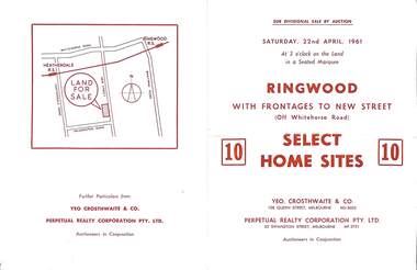
Flyer, Auction sale brochure advertising home sites with frontages to New Street, Ringwood, Victoria - 1961
Advertisement for Sub-divisional sale by auction on Saturday, 22nd April, 1961, with terms of sale of 10 home sites with frontages to New Street, Ringwood, Victoria.Location map showing land for sale on New Street, Ringwood, north of Palmerston Road. Auctioneers in conjunction - Yeo, Crosthwaite & Co., 108 Queen Street Melbourne (Telephone) MU 8605, and Perpetual Realty Corporation Pty. Ltd., 62 Swanston Street, Melbourne (Telephone) MF 3721. -
 City of Moorabbin Historical Society (Operating the Box Cottage Museum)
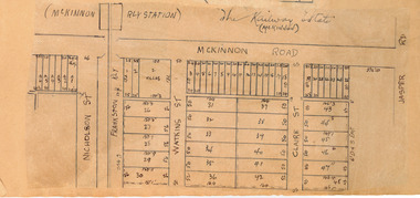
Plan - McKinnon Railway Estate, McKinnon, c 1921
At the end of World War One, there was a renewed interest in residential land and a number of estates opened up in the Municipality of Moorabbin. The train line from the city to Frankston was electrified in 1922 which intensified the sale in the municipality of Moorabbin, particularly land which was in the vicinity of the railway stations.Example of the progress of the Municipality of MoorabbinHand drawn plan of the McKinnon Railway Estate, McKinnonMcKinnon Railway Estate, McKinnon - hand drawn planmckinnon road, watkins street (now bent street), claire street, real estate, mckinnon, moorabbin -
 Tatura Irrigation & Wartime Camps Museum
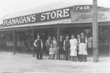
Photograph, Flanagan's Store, 2001
T.Flanagan, b.1869, Bullengarook, via Gisborne. At age 23, went to N.S.W. After 2 years went to Tatura and commenced business in shop built by T.Hogan on land next to Brown & Hogan'a butchery, Hogan Street. Land in 1979 owned by Harold Chambers.flanagan, cook, photograph, people -
 Orbost & District Historical Society
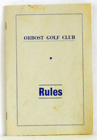
booklet, Snowy River Mail as "Mail" Print, Orbost Golf Club Rules, 1968
Published by the Orbost Golf Club.The golf club was established in 1906 it was originally formed as the Snowy River Golf Club and played on private land near the banks of the Snowy River just to the south of town. In the 1930’s the Golf Club relocated to its present site and was renamed Orbost Golf Club. The land was shared by the Show grounds and Racing Club. Orbost Golf Club later acquired the land outright to provide a permanent home for golfers in Orbost and surrounding district.A thin, 24pp booklet with a grey cover titled "Orbost Golf Club Rules". It contains the rules of the Orbost Golf Club and has a loose sheet with amendments. The cover has blue print.orbost-golf-club recreation sport golf -
 Robin Boyd Foundation
Letter, Harold Lander to Robin Boyd and others. (Crawford Productions), 23.11.1967
Memo from Harold Lander, providing background information for a planning meeting to be held to discuss ‘Hunter’ television series. 'Hunter' is an Australian spy drama which ran from 4 July 1967 – 5 March 1969 on Nine Network. Lander writes about considerations for making the show commercially successful including publicity tactics. Robin Boyd is mentioned on page 9. Lander asks for his suggestion on a new set design for the Independent Surveys office for the show.Crawford Productions and Robin Boyd also explored ideas for other television productions, besides the successful 'The Flying Dogtor" series.Typewritten, carbon copy, foolscap, 11 pages.Black pen mark up on pages 1-9, red pen mark up on pages 1 and 2.hunter, australian television, crawford productions, homicide, nine network -
 City of Kingston
Photograph - Colour, Paul Tresize, 1998
The name Mordialloc was derived from the name Moody Yallock, which comes from the Bunurong language. The Bunurong Peoples are the Traditional Owners of this area. The name means “high water” or “high creek”. In 1839, colonial authorities declared the mouth of the creek, and an additional 830 odd acres as an Aboriginal Reserve, although this proclamation was never gazetted. The reserved land included part of the Carrum Carrum Swamp which was abundant with wild life and natural resources. Regular encroachments, including land sales which began in 1863, were made on the land until 1878 when the Reserve was declared closed, and the land was opened up to land sales. Market gardening and suburban house lots quickly began to develop, and Mordialloc became a renowned picnic and holiday site. Mordialloc Creek is a popular bay side destination for local and visitors, and is a site for boating, kayaking, fishing and swimming, along with many other activities.Colour photograph of Mordialloc Creek, looking out to the bay. Many small fishing and leisure craft are moored on either side of the banks of the creek. To the right hand side can be seen parklands, while the left hand side has a small inlet in which more small crafts are moored.mordialloc, bunurong, traditional owners, suburbs, boats, fishing, waterways -
 City of Kingston
Photograph - Colour, 1998
The name Mordialloc was derived from the name Moody Yallock, which comes from the Bunurong language. The Bunurong Peoples are the Traditional Owners of this area. The name means “high water” or “high creek”. In 1839, colonial authorities declared the mouth of the creek, and an additional 830 odd acres as an Aboriginal Reserve, although this proclamation was never gazetted. The reserved land included part of the Carrum Carrum Swamp which was abundant with wild life and natural resources. Regular encroachments, including land sales which began in 1863, were made on the land until 1878 when the Reserve was declared closed, and the land was opened up to land sales. Market gardening and suburban house lots quickly began to develop, and Mordialloc became a renowned picnic and holiday site. Mordialloc Creek is a popular bay side destination for local and visitors, and is a site for boating, kayaking, fishing and swimming, along with many other activities.Colour photograph of Mordialloc Creek, looking inland.Small fishing and leisure boats are moored on either side of creek, with a view of the Mordialloc Bridge Hotel in the background.mordialloc, bunurong, traditional owners, suburbs, boats, fishing, waterways, hotel -
 City of Kingston
Photograph - Colour, Paul Tresize, 1998
The name Mordialloc was derived from the name Moody Yallock, which comes from the Bunurong language. The Bunurong Peoples are the Traditional Owners of this area. The name means “high water” or “high creek”. In 1839, colonial authorities declared the mouth of the creek, and an additional 830 odd acres as an Aboriginal Reserve, although this proclamation was never gazetted. The reserved land included part of the Carrum Carrum Swamp which was abundant with wild life and natural resources. Regular encroachments, including land sales which began in 1863, were made on the land until 1878 when the Reserve was declared closed, and the land was opened up to land sales. Market gardening and suburban house lots quickly began to develop, and Mordialloc became a renowned picnic and holiday site. Mordialloc Creek is a popular bay side destination for local and visitors, and is a site for boating, kayaking, fishing and swimming, along with many other activities.Colour photograph of Mordialloc Creek, looking inland. Boats are moored on either side of the creek and the Bridge Hotel is visible in the background.mordialloc, bunurong, traditional owners, suburbs, boats, fishing, waterways, hotel -
 City of Kingston
Photograph - Colour, Paul Tresize, 1998
The name Mordialloc was derived from the name Moody Yallock, which comes from the Bunurong language. The Bunurong Peoples are the Traditional Owners of this area. The name means “high water” or “high creek”. In 1839, colonial authorities declared the mouth of the creek, and an additional 830 odd acres as an Aboriginal Reserve, although this proclamation was never gazetted. The reserved land included part of the Carrum Carrum Swamp which was abundant with wild life and natural resources. Regular encroachments, including land sales which began in 1863, were made on the land until 1878 when the Reserve was declared closed, and the land was opened up to land sales. Market gardening and suburban house lots quickly began to develop, and Mordialloc became a renowned picnic and holiday site. Mordialloc Creek is a popular bay side destination for local and visitors, and is a site for boating, kayaking, fishing and swimming, along with many other activities.Colour photograph of Mordialloc Creek with boats moored on both sides of the street and Pompei's boat yard visible on the right hand side of the creek., Main Street and St Brigid's Catholic Church are visible in backgroundmordialloc, bunurong, traditional owners, suburbs, boats, fishing, waterways, hotel, church -
City of Kingston
Photograph - Colour, Paul Tresize, 1998
The name Mordialloc was derived from the name Moody Yallock, which comes from the Bunurong language. The Bunurong Peoples are the Traditional Owners of this area. The name means “high water” or “high creek”. In 1839, colonial authorities declared the mouth of the creek, and an additional 830 odd acres as an Aboriginal Reserve, although this proclamation was never gazetted. The reserved land included part of the Carrum Carrum Swamp which was abundant with wild life and natural resources. Regular encroachments, including land sales which began in 1863, were made on the land until 1878 when the Reserve was declared closed, and the land was opened up to land sales. Market gardening and suburban house lots quickly began to develop, and Mordialloc became a renowned picnic and holiday site. Mordialloc Creek is a popular bay side destination for local and visitors, and is a site for boating, kayaking, fishing and swimming, along with many other activities.Colour photograph of Mordialloc Creek with boats moored on both sides of the street and Pompei's boat yard visible on the right hand side of the creek., Main Street and St Brigid's Catholic Church are visible in background.mordialloc, bunurong, traditional owners, boats, fishing -
 Whitehorse Historical Society Inc.
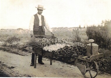
photograph - photocopy, Jones Flower Farm
In 1905 Walter Jones bought twenty five acres of land in Mt Pleasant Road Nunawading South to establish a flower farm. Plants and flowers were transported to the city by rail. In 1957 some of the land was sold to the Education Dept to erect the Nunawading South Primary School.Black and white copy of Walter Jones with a barrow load of flowers.walter jones, jones flower farm. -
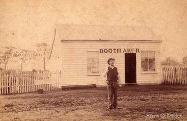 Melton City Libraries
Photograph, William Daley, c.1863
Elizabeth married William Daley. They obtained land on High Street Melton. Their house and bootmaker shop was situated on this block of land. They had two daughters Ann and Elizabeth. Elizabeth had a haberdashery shop and died in 1949. Her sister died in 1933. They are buried at the Melton CemeteryPhotos of Daley in front of his shop and portrait photolocal identities -
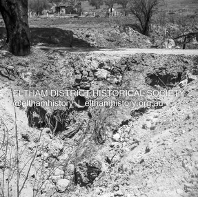 Eltham District Historical Society Inc
Negative - Photograph, J.A. McDonald, Buttermans Track, St Andrews, April 1962
Culvert which discharges onto Crosby's land Circa April 1962Record of various Shire of Eltham infrastructure works undertaken during the period of 1952-1962 involving bridge and road reconstruction projects, sometimes with Eltham Shire Council Project Reference numbers quoted. It was during this period that a number of significant improvements were made to roads and new bridges constructed within the shire that remain in place as of present day (2022). In many situations, the photos provide a tangible visible record of infrastructure that existed throughout the early days of the Shire. The album was put together by or under the direction of the Shire Engineer, J.A. McDonald.1962-04, buttermans track, infrastructure, shire of eltham, st andrews, bridge construction -
 Greensborough Historical Society
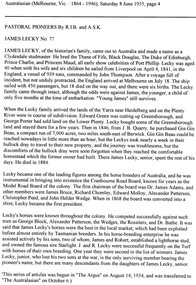
Article - Newspaper Clipping (copy), James Lecky, 08/06/1835
James Lecky was a pioneer horse breeder, initially occupying land in Greensborough1 p. typescriptlecky family, james lecky -
 Greensborough Historical Society
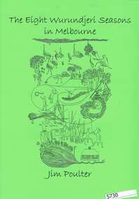
Booklet, Jim Poulter, The Eight Wurundjeri seasons in Melbourne, by Jim Poulter, 2015_
Description of the seasons occurring in Melbourne and their effect on Aboriginal culture and land management.15 p., booklet, illus.aborigines, aborigines victoria, melbourne -
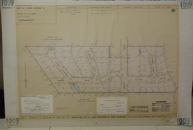 Greensborough Historical Society
Planning document, Subdivision Plan #1009. Corner Allumba Drive and Beales Road Greensborough, 1981_
Plan of Subdivision of land at corner of Allumba Drive and Beales Road Greensborough.An example of hard copy subdivision plans from the Greensborough area. Mainly from the Shire of Diamond Valley era (1964-1994).Plan (2 sheets) mounted on heavy card.Stamped and handwritten Council permissions, dates and other details.subdivision plans, allumba drive, beales road -
Lakes Entrance Regional Historical Society (operating as Lakes Entrance History Centre & Museum)
Photograph, Lakes Post Newspaper, 1/04/2014 12:00:00 AM
Traffic was reduced to single land temporary traffic lights were installedColour photograph showing a Vic Roads staff member standing beside a landslip on the Princes Highway at Jemmys Point Lakes Entrance Victoriabridges -
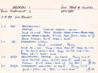 The Beechworth Burke Museum Research Collection
Card (Series) - Index Card, George Tibbits, Corner of Ford and Church Streets, Beechworth, 1976
George Tibbits, University of Melbourne. Faculty of Architecture, Building and Town & Regional PlanningIndex system that support the research for Beechworth : historical reconstruction / [by] George Tibbits ... [et al]Arranged by street names of BeechworthEach index card includes: street name and number of property, image of property, allotment and section number, property owners and dates of ownership, description of the property according to rate records, property floor plan with dimensions.beechworth, george tibbitsbeechworth, george tibbits -
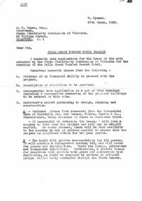 Falls Creek Historical Society
Document - Application For Lease Of Site Selected By S.E.C, 27.03.1963
Bob (Herman) Hymans (a former member of the Royal Netherlands Navy) was born in Bloemendaal, Holland on 30th September 1922. During World War II he fought against the Japanese in the Dutch East Indies (now Indonesia) and was imprisoned in Changi and on the Burma Railway. After gaining qualifications as a Ski Instructor, Bob arrived in Falls Creek in July 1950. Working as an Instructor and Supervisor at Bogong Lodge, Bob decided his future was in accommodation. He was successful in negotiating an indenture for land from the State Electricity Commission (SEC). It took Bob two years to build his Grand Coeur Chalet but, tragically, it was burned down in August 1961. Bob also built the first Chairlift in Australia. This was a single chairlift and the structure was built from wooden electricity poles. He was constantly full of new ideas and proposals for the village. Bob Hymans die on 7th July 2007. This Collection of documents and letters tells the story of Bob's endeavours to develop Falls Creek into the ski village it is today.This item is significant because it documents proposals put forward by Bob Hymans to develop facilities in the Falls Creek Tourist Area.A letter of application from Mr Hymans for the lease of land offered by the State Electricity Commission to develop a tourist hotel. His hotel would provide accommodation for 100 guests. It would contain a dining-room seating 140 and cater for guests and day-visitors. Other facilities included a lounge, public-bar and lounge-bar facilities. A private lounge for reception would also provide guest and convention facilities. His project was designed as a year-round resort hotel. As well as serving as a winter sports hotel, the plan featured indoor facilities including a heated swimming pool, squash courts, bowling alley and sauna bath. Stables, a tennis court and boats would also attract year-round tourism. The budgeted cost was £130,000 plus bowling alley equipment. He planned that construction would commence in October, 1963 and be completed in June, 1965.falls creek tourist area management committee, hymans' hotel plans, falls creek development -
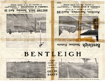 City of Moorabbin Historical Society (Operating the Box Cottage Museum)
Flyer - Bentleigh Station Estate Auction, Coghill & Haughton - W.H. Wood, Bentleigh, c1914
One of the first sales in the district since the land boom which began in 1881when the train line to Mordialloc was built. The land boom came to a halt in the 1890's due to the depression. This sale was also successful as the electrification of the train line from the city to Frankston had been announced.Example of the progress of the Municipality of Moorabbin.Advertising flyer for auction of real estate sales - plan of building blocks for sale - pictures of local area50 Choice Building Blocks adjoining Bentleigh Railway Stationcentre road, mavho street, loranne street, burgess street, bentleigh, bentleigh railway station, real estate, auctions -
 Bendigo Historical Society Inc.
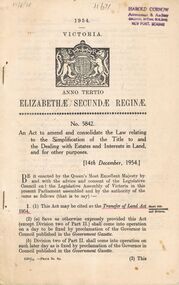
Book - 1954 VICTORIA ANNO TERTIO ELIZABETHÆ SECUNDÆ REGINÆ NO. 5842, 17/8/56
A small book owned by Accountant & Auditor Harold Curnow detailing the "Simplification of Title to and the Dealing with Estates and Interests in land for for other purposes", it also has the date 17/8/56 written in pencil on the top left corner. The first page is written as following. "17/8/56 Harold Curnow Accountant & Auditor Colonial Mutual Building View Point, Bendigo 1954 VICTORIA ANNO TERTIO ELIZABETHÆ SECUNDÆ REGINÆ No. 5842. An Act to amend and colidate the law relating to the Simplification of the title to and the Dealing with Estates and interests in Land and for other purposes. [14th December, 1954.] Be it enacted by the Queen's most Execellent Majesty by and with the advice and consent of the Legislative Council and the Legislative Assembly of Victoria in this present Parliament assembled and by the authority of the same as follows (that is to say) 1. (1) this Act may be cited as the Transfer of Land Act 1954. (Short title commencement and division) (2) (a) Save as otherwise ecpressly provided this act (except Division two of Part II.) shall come into operation on a day to be fixed by proclamation of the Governor in Council published in the Goverment Gazette. (b) Division two of Part II. shall come into operation on such later day as is fixed by proclamation of the Governor in Council published in the Goverment Gazette 6325/55 -Price 3s. 9d. (3) This"victoria -
 Melbourne Tram Museum
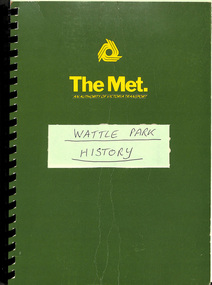
Document - Report, The Met, "Wattle Park", 1989
Report - approx. 90 A4 photocopied sheets, within a green cover preprinted for "The Met", titled "Wattle Park" containing many documents concerned with the history of Wattle Park and its status legally within a black comb binder. Comprises: 1 - Map 2 - two page letter from Tom Roper Minister for Planning and Environment to Jim Kennan Minister for Transport dated 22/11/1988. 3 - two page history 4 - two page extract from the Nov - Dec 1966 issue of MMTB News 5 - 23 pages - handwritten "Notes of Address on early history of Wattle Park given by A. J. Holt to the Box Hill Historical Society Nov. 1986. 6 - 10 page extract of the Act authorising the HTT to acquire the land and extracts from Hansard 7 - 4 page letter by the Office of the Solicitor to The Met Property department 1/12/1986 about the use of the land and charging fees for its use. 8 - 15 page legal advice re the use of the land and its permitted uses. 9 - 13 page follow up advice by P. N. Wikrama dated 20/6/1989 10 - 6 page photocopy of the certificates of title. Each section separated by a green sheet.trams, tramways, wattle park, legal agreements, htt, mmtb, the met, minister for transport -
 Bendigo Military Museum
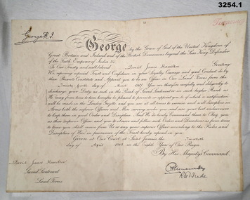
Certificate - CERTIFICATE, OFFICER WW1, 1) 24.3.1917
Items re David James Wallace HAMILTON No 329 . KIA 7.6.1917. Refer Cat No No 2351.5P for his service details..1) Certificate, cardboard, yellowed, folded re David James HAMILTON being for his appointment to 2nd Lieutenant. Printed in black with black pen writing ornate. Stamped seal on one side. .2) Envelope for .1) Paper yellowed with black print..1) Bottom L: "D J Hamilton Second Lieutenant Land Forces Australian Machine Gun Corps" .2) Printed top centre: "ON HIS MAJESTY'S SERVICE" Printed bottom L: "DEPT OF DEFENCE MELBOURNE" Handwritten centre: "Mrs L Hamilton Royal Hotel Williamstown Vic"certificate, officer -
 Bendigo Military Museum
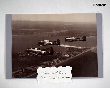
Photograph - PHOTOGRAPH, RAAF WIRRAWAY AIRCRAFT
.1) and .2) depict WW2 RAAF Wirraway aircraft flying in formation. Part of Flight Lieutenant Ian A. 'Joe' Lyons MBE Collection. See Catalogue No. 5374P for details of his service record..1) Black and white photograph of three RAAF aircraft flying in formation over a built-up landscape. Photograph is mounted on mauve coloured cardboard. A handwritten caption is attached to the bottom of the photograph. .2) Black and white photograph of four RAAF aircraft flying in formation over land. Photograph is mounted on mauve coloured cardboard. A handwritten caption is attached to the bottom of the photograph..1) Caption: 'THIS IS A "GEM", "B" FLIGHT AGAIN'. .2) Caption: 'THIS IS THE "BIG DADDY" OF FORMATIONS. HERE YOU SEE "B" FLIGHT IN CLOSE FIGHTING FORMAT'.raaf, wirraway aircraft, ian a. 'joe' lyons, photograph -
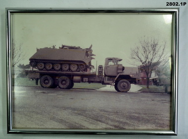 Bendigo Military Museum
Photograph - PHOTOGRAPH, FRAMED & PHOTOGRAPHS, post 1970
.1) Framed coloured photo of tray truck with personal carrier aboard, silver metal frame with glass front & khaki hanging cord. .2) Coloured photo of recovery vehicle towing a troop carrier vehicle. .3) Coloured photo of army vehicle No 12 in bush setting. .4) Coloured photo of land rover under camouflage net in bush setting..1) On stickers on back of frame: "Sgt Jones - APC Lift 9-10-11 Sep - 1984 - Cobram - Hay - 468 klms Trust No 5"photography-photographs, frame accessories, military history, passchendaele barracks trust -
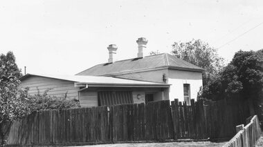 Ringwood and District Historical Society
Photograph, Original Ringwood Police Station built 1988 (undated)
Black and white photograph. Typed beneath photograph, "Original Ringwood Police Station (Brick building). 32 Mt. Dandenong Rd. (Police Station 1888)." Written on backing sheet, "R.H. Building was first station. Site cost 20 pounds in 1888. Mtd. Const. Waters first to occupy it. Building and land sold 1973 for 20.000 32 Mt.Dand. Rd." -
 Federation University Historical Collection
Booklet - Report, Report and Recommendations to the Council of the School of Mines and Industries, Ballarat on the Master Plan for the Mt Helen Development, 11/1968
A master plan for the campus was developed by L.H. Vernon and Associates. Geoff J. Harrison prepared a report and made recommendations on the master plan, including suggestions for improvement. Grey card covered, stapled, foolscap report on the Mount Helen Development. It included 14 typed pages and 6 plans. The report covers: Campus planning, Mt Helen Master Plan, retention of trees, sports fields, student accommodation, student amenities, library, car parking, site, landscape, land use study, Mt Helen Site, L.H. Vernon.mount helen master plan, masterplan, master plan, vernon, g.j. harrison, harrison, education, topography, survey, jd fisher, aa jeffreys, hugh mitchell, john vernon, geoff harrison, mount helen master plan, l.h. vernon, campus plan, mount helen campus -
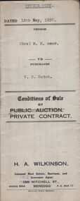 Bendigo Historical Society Inc.
Document - H.A. & S.R. WILKINSON COLLECTION: CONTRACT OF SALE
Conditions of sale by private contract dated 13th May, 1937 between Mrs. M.H. Amor (seller) and V.F. Sutch (buyer) for land situate Hayes Street, Bendigo being lot 2 on plan of subdivision, having a frontage of approx. 57 feet to Hayes Street, by a varying depth, being part of Crown allotment 510 section A. Price 60 pounds.organization, business, h.a. & s.r wilkinson real estate