Showing 178929 items
matching streets
-
 The Beechworth Burke Museum
Photograph
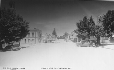
This copy of a postcard from the Rose series depicts Ford Street looking South. This postcard is part of the Rose Series produced by Victorian photographer George Rose’s business, the Rose Stereograph Company. George Rose (1861-1942), is considered one of Australia's best photographers of the late 19th and early 20th centuries. The Rose Stereograph Company was founded in 1880 and became famous for producing stereographs, or stereoviews, which gave the illusion of being in 3D when seen through a hand-held viewer, a big craze of the era. As stereographs lost popularity in the 1920s, Rose switched to production of postcards and decorative cards, and he and the photographers who followed took thousands of scenes around Victoria as well as interstate that became iconic images of Australian life.Black and White photograph (copy) on gloss photographic paper. Obverse: THE ROSE SERIES P.10544 COPYRIGHT FORD STREET, BEECHWORTH, VIC Reverse: BMM7746 PH 147 1998.00059beechworth, rose series, ford street, burke museum, postcard -
 Ringwood and District Historical Society
Newspaper - Clippings, Death of Miss Winifred Thomas of Alexander Avenue, Ringwood - June 1942
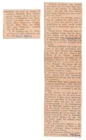
Death notice in local newspaper - Ringwood Mail 18/6/1942, and separate report of Miss Thomas being hit by a car driven by R. Naylor while crossing Station Street, Ringwood.Winifred Elva, beloved second daughter of H.O. and A. Thomas of Alexander Road Ringwood, and much loved sister of Grace,Rhys (deceased), Horace, Cornish, Rita, Elma and Gwen (Mrs Ron Westmore). Miss Thomas was well known in the district and for some years in business in Main Street, Ringwood. She was associated with church work including superintendent of the kindergarten at the Methodist Sunday school and the Junior Christian Endeavor. -
 Bendigo Historical Society Inc.
Administrative record - McDonald's Reef Gold Mining Company Minute Book, 1913 to 1915
McDonalds Reef Gold Mining Company was located at Fryerstown. The registered office of the Company was at High Street, Bendigo. Minute book of the McDonald's Reef Gold Mining Company. Black cover with maroon binding, one hundred and eighty-nine pages, hand written entries dating from Monday June 30th, 1913 to 23rd July 1915. The first meeting of shareholders was held at Scotts Hotel, Collins Street, Melbourne. bendigo, gold mining, shareholders, share transfers, kong meng gold reefs, dargo, margaret roberts collection -
 Sunbury Family History and Heritage Society Inc.
Photograph, Former Yakka Factory
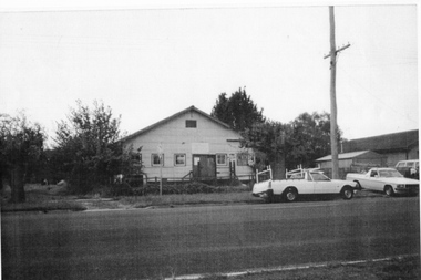
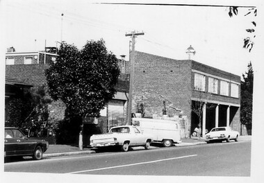
In the 1950s there was a move to bring some light industries into Sunbury. The large building in Barkly Street, which was used to make gloves and other items of clothing was taken over by the Yakka Company and boys shorts were made there. In the 1960s the Yakka Company moved to new and larger premises in Broadmeadows resulting of the closure of the Sunbury factory. A car park which services the business owners and employees from O'Shanassy Street now occupies the site.The Yakka Factory was one of the early manufacturing ventures to be started in Sunbury.A non-digital scanned copy of a coloured photograph of a large shed-like building with two utility trucks parked in the street in front of the building. There are some tall shrubs on either side of the building and a tall electric light pole on the RHS of the picture.He photograph has a narrow cream border.yakka factory, barkly street, manufacturing -
 Federation University Historical Collection
Photograph, Ballarat Post Office and surrounds from the Ballarat Town Hall Tower, 2006, 2006
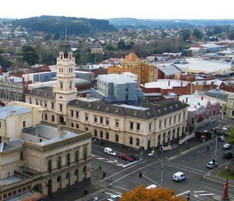
Around 1878 a series of photographs were taken from the newly completed Ballarat Town Hall tower. These photographs replicated the scenes of Ballarat around 135 years later.A series of digital images taken from the Ballarat Town Hall tower by Lisa Gervasoni. Buildings include the Ballarat Post Office, showing the newer buildings of the University of Ballarat's Arts Academy behind it. Streets shown at Sturt Street, Camp Street and Lydiard Street. One black and white image is also printed onto paper. university of ballarat, ballarat townscape, arts academy, camp street, ballarat post office, sturt street, lydiard street, ballarat streetscape -
 Bendigo Historical Society Inc.
Newspaper - JENNY FOLEY COLLECTION: THE LAST BLOCK IN VIEW STREET
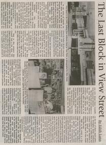
Bendigo Weekly from Friday, August 17, 2001. The last block in View street - by Edith Lunn. The previous articles on View Street in its heyday as a shopping precinct dealt with the two blocks from Barnard Street to McKenzie Street. In the last article looks at the remaining block from McKenzie to View Point. The clip is in a folder.newspaper, bendigo, bendigo weekly -
Bendigo Historical Society Inc.
Photograph - LA TROBE UNIVERSITY BENDIGO COLLECTION: BENDIGO
A black and white photograph of McCrae Street Bendigo in April 1969. There are bicycles and cars parked in front of the businesses which include the Commonwealth Employment Service, Spero's Cafe a butcher and the Bendigo Advertiser. Bridge Street is leading off McCrae Street on the left hand side and the gold statue can be seen at the junction of the two streets. See 3320.100bendigo, streetscape, mccrae street, la trobe university bendigo collection, collection, bendigo, streetscape, mccrae street, bridge street, j.c. burnett, geoff pryor, photo, photos, photograph, photographs, history -
 Bendigo Historical Society Inc.
Document - LONG GULLY HISTORY GROUP COLLECTION: LONG GULLY NAMES STREET BY STREET
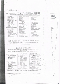
Five pages of copies of residents of streets in Long Gully including Derwent Gully, Sparrowhawk and St Just Point. Numbers beside names are possibly street numbers. Street names have E Side, W Side, N Side or South Side. These pages have been photocopied from a street directory. Date unknown.bendigo, history, long gully history group, the long gully history group - long gully residents street by street, derwent gully, sparrowhawk, st just point -
 Kew Historical Society Inc
Plan, Melbourne and Metropolitan Board of Works, Borough of Kew : Detail Plan No.1580, 1904
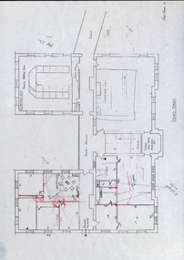
The Melbourne and Metropolitan Board of Works (MMBW) plans were produced from the 1890s to the 1950s. They were crucial to the design and development of Melbourne's sewerage and drainage system. The plans, at a scale of 40 feet to 1 inch (1:480), provide a detailed historical record of Melbourne streetscapes and environmental features. Each plan covers one or two street blocks (roughly six streets), showing details of buildings, including garden layouts and ownership boundaries, and features such as laneways, drains, bridges, parks, municipal boundaries and other prominent landmarks as they existed at the time each plan was produced. (Source: State Library of Victoria)This plan forms part of a large group of MMBW plans and maps that was donated to the Society by the Mr Poulter, City Engineer of the City of Kew in 1989. Within this collection, thirty-five hand-coloured plans, backed with linen, are of statewide significance as they include annotations that provide details of construction materials used in buildings in the first decade of the 20th century as well as additional information about land ownership and usage. The copies in the Public Record Office Victoria and the State Library of Victoria are monochrome versions which do not denote building materials so that the maps in this collection are invaluable and unique tools for researchers and heritage consultants. A number of the plans are not held in the collection of the State Library of Victoria so they have the additional attribute of rarity.Original survey plan, issued by the MMBW to a contractor with responsibility for constructing sewers in the area identified on the plan within the Borough of Kew. The plan was at some stage hand-coloured, possibly by the contractor, but more likely by officers working in the Engineering Department of the Borough and later Town, then City of Kew. The hand-coloured sections of buildings on the plan were used to denote masonry or brick constructions (pink), weatherboard constructions (yellow), and public buildings (grey). The area represented in this detail plan has undergone significant change during the 20th century. The widening of High Street in the 1930s and 1950s involved the shops on the south side of High Street being demolished and later rebuilt to fit the widened street. Another significant loss was the mansion ‘Drayton’ fronting Wellington Street, owned at this stage by Susannah Fenton. Her family name would later to be given to Fenton Way, which was to be built over the grounds of the house following its demolition. The plan of the garden is particularly interesting, containing a batten dome fronting Wellington Street, an ornamental pond, a fountain and a brick and glass conservatory. The notes by the plumbing contractor on this plan are particularly detailed. Pink borders delineate the ownership of the varying parcels of land. Some of the better known owners listed include the real estate agent Cr. Henry de Castres Kellett (bt) and John Padbury, the funeral director. This particular plan provides a clear view of the configuration of the Kew Junction in 1903 and the commercial buildings that surrounded it.melbourne and metropolitan board of works, detail plans, maps - borough of kew, mmbw 1580, cartography -
 Sunbury Family History and Heritage Society Inc.
Photograph, Royal Hotel, Pre 1936
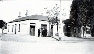
The hotel in the photograph is the original single storey Royal Hotel with its corner entrance. It stood on the south -east corner of Evans and Brook Streets in Sunbury. The original building was damaged by fire in 1936 and a two storey red brick building replaced it on the original site with the hotel entrance facing onto Brook Street. The hotel is in close proximity to the railway station so it was able to offer accommodation to travellers visiting the Asylum.The Royal Hotel is one of two surviving hotels built in Evans Street. Originally there were four hotels built between Station and Brook Streets along Evans Street.A non-digital black and white photograph of a white single story hotel building showing the original corner entrance and three men standing beside it in the street. There are two other entrances on each side and three windows down one side. The iron clad roof has three chimneys.royal hotel, sunbury, hotels, brook street, evans street -
 Warrnambool and District Historical Society Inc.
Document, Accounts, Early and Middle 20th Century
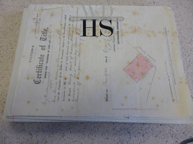
These pages of accounts are from the firm of Mackay Taylor, Lawyers, a prominent firm in Warrnambool for over 100 years. The Warrnambool legal businesses of George Mackay and James Fletcher merged in 1893 and was known as Fletcher and Mackay. In the 1920s Mr Mackay took J. McD Taylor as a partner and the premises at 131 Kepler Street were built about that time, with the firm being known as Mackay and Taylor. After the original partners died there was a succession of partners with the legal firm continuing as Mackay Taylor until the 1990s. These account sheets from a prominent 20th century legal firm in Warrnambool are of considerable importance as they document the legal records of many Warrnambool and district personalities from the early 20th century. The information contained in the sheets will therefore add to the known history of many local people from the past and will be very useful to researchers.These are handwritten accounts for bills to be paid to Mackay Taylor Lawyers for services rendered. The accounts are described in detail and are written on quarto size paper with the requisite red lines already printed on the pages. There are over 100 sheets and they date from 1938 to 1940. There are also two original Certificates of Title for Eva Willis (1916, portion of land in Cramer Street) and Archie Jackson (1924, portion of land in Cramer Street). warrnambool, warrnambool lawyers -
 Northern District School of Nursing. Managed by Bendigo Historical Society Inc.
Photograph - Photo of first year nurses
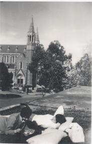
The Northern District School of Nursing opened in 1950 in to address the issues around nurse recruitment, training and education that had previously been hospital based. The residential school was to provide theoretical and in-house education and practical training over three years. The students would also receive practical hands-on training in the wards of associated hospitals. The Northern District School of Nursing operated from Lister House, Rowan Street, Bendigo. It was the first independent school of nursing in Victoria and continued until it closed in 1989.Black and white photo of two nurses, from school 43, in civilian clothes relaxing outside the Hostel in Wattle Street. The Sacred Heart Cathedral is in the background. In biro on reverse - Weekend photo at Wattle Street Hostel. On a separate sheet the following information in biro- At Wattle St. Hostel. Sacred Heart Cathedral in background. Weekend relaxing. L-R 1. Jan Goss 2. Louise Murphy -
 Ringwood and District Historical Society
Plan - Proposed Ringwood East Railway Station, VR Ringwood-Croydon (Dublin Road) - 1923
Technical drawing of "Proposed Station At 16Mls 38Chs 89Lks (Dublin Road)" inluding boundary line, red shaded platform with station buildings, and green shaded possible future "up" track. Surrounding streets include Dublin Road, Patterson Street, and subsequent hand-written additions of Railway Avenue, Lawrence Grove, Stanley Avenue, Wenwood Street, and Lois Street. Land title details of Patterson Street properties mainly illegible.Scale: 40'=1". Possible future (platform) extension for 8 car trains (and) extension for 10 car trains. -
 Federation University Historical Collection
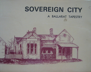
Book, Sovereign City: A Ballarat Tapestry, 1974
Hard covered book of 80 pages with a yellow dust jacket. Many sketches including Armstrong Street, Lydiard Street, Montrose Cottage Eureka Street, Lauderdale, Ballarat Railway Station. Bailey's Mansion, Former Ballarat Gaol, Ballarat Town Hall, Camp Street Police Station. Ballarat East Post Office, Ballarat Synagogue, Lal Lal blast furnace, Sovereign Hill, Mount Buninyong, Dana Street Primary School. non-fictionballarat, buildings, architecture, edward heffernan -
Glenelg Shire Council Cultural Collection
Photograph - Photograph - Julia Street, Portland, 1859
Vern Mc Callum CollectionDigital copy of a monochrome photo of Portland, N 1859 View of buildings on south side of Julia street, between Percy and Bentick streets.photography, vern mccallum, portland cbd -
 Eltham District Historical Society Inc
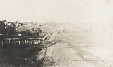
Photograph, Brougham Street, Eltham, early 1900s, 1900s
Colour photograph of a poor quality photograph (in album) of Brougham Street, Eltham looking east from near Susan Street, early 1900seltham, brougham street, wellington street, susan street -
 Eltham District Historical Society Inc
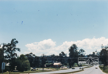
Photograph, M. North, Main Road, Eltham near Fitzsimons Lane Roundabout, Dec 1985, 1/12/85
Two colour photographs of Main Road, ElthamSouth between Falkiner Street and Bolton Street at the roundabout of Fitzsimons Lane, Eltham, Dec 1985Noted on 463B 'See 1934 small black and white snap of flooded bridge and the same two shops. This snap taken from same location, Dec 1985. Old Eltham Park on right of photo The two shops at left (Ansel and Muir) Road ahead crosses new bridge over the Diamond Creek, Eltham Main Road now dual highway, through Lower Plenty to this bridge'main road, eltham, eltham south, fitzsimons lane, round about, falkiner street -
 Federation University Historical Collection
Building Plan, School of Mines Lydiard Street Administration Building, Late 1970s
Office spaces in SMB, Lydiard Street Administration Building at street level. Each of the five photocopies shows a different arrangement of the Council Room.ballarat school of mines, administration building, plans, lydiard street, offices -
Port Melbourne Historical & Preservation Society
Photograph - Walkthrough lane between Princes and Station Streets, Port Melbourne, Pat Grainger, 1998
Taken and annotated by Pat Grainger for the "Lurking in the Lanes" book project and finally donated to the PMH&P Society in 1998Four original colour photographs of walkthrough lane between Princes and Station Streets (one lead-off at Liardet with two into Station Street)built environment - domestic, engineering - roads streets lanes and footpaths -
Port Melbourne Historical & Preservation Society
Photograph - Station Street, Port Melbourne, 1907
Station Street Port Melbourne approximately 1907. Shows Emerald House on corner Station and Raglan Streets. Image was taken from postcard.built environment - domestic, station street, emerald house -
Port Melbourne Historical & Preservation Society
Photograph - Beach Street from demolition site of Housing Commission off Princes Street, Port Melbourne, Peter Libbis, 26 Dec 1990
Colour photograph looking toward Beach Street from housing commission site. Behind crane, corner of Rouse and Princes Streets. 26.12.1990built environment -
Port Melbourne Historical & Preservation Society
Plan - Tramway, Normanby Road, Ingles Street to Boundary Street, Port Melbourne, 14 Mar 1893
Plan of tramway in Normanby Road from Ingles Street to Boundary Street, together with written specification for works attached (Reg 66.2), 1893.A.V. Heath (Town Surveyor) J.J. Bartlett (Mayor)engineering - roads streets lanes and footpaths, transport - tramways, town planning, town clerks, mayors, arthur victor heath, james john bartlett -
 Port Melbourne Historical & Preservation Society
Photograph - Heath Street, Port Melbourne, 1980
B&W photo of Heath Street, east side, looking south towards Spring Street and town hall tower c 1970sbuilt environment - domestic, antonio cannatelli, heath street -
Port Melbourne Historical & Preservation Society
Photograph - Aerial view of Port Melbourne, 1931
Section of aerial photograph of Port Melbourne c1931 (refer item 574), covering Beach almost to Bridge Street and Lagoon to Bay Streetsandridge lagoon, built environment -
Port Melbourne Historical & Preservation Society
Photograph - Graffiti below Graham Street overpass, Port Melbourne, Pat Grainger, 1991
Original colour photograph of graffiti below the Graham Street overpass, taken from Station Street looking West toward the tram linebuilt environment - civic, arts and entertainment - visual arts, graham street -
Port Melbourne Historical & Preservation Society
Photograph - Wesleyan Methodist Church, corner Nott and Graham Streets, Port Melbourne, Douglas Smallpage?, 1960s
Small, original black and white photograph of Wesleyan Methodist Church, corner of Graham and Nott Streets (viewd from Graham Street) 1960sreligion - wesleyan methodist church, doug smallpage (?), stan mclennan, jack mclennan -
Port Melbourne Historical & Preservation Society
Photograph - Group of people in Lalor Street outside Capace's liquor store, Port Melbourne, 1960s
Photo taken outside Capace's liquor store at corner of Lalor and Pool Streets, late 1960s - group of people waiting in Lalor Streetbusiness and traders - wine and spirits, wallace george wale, con talorico, capace - port melbourne wine merchant -
 Charlton Golden Grains Museum Inc
Photograph, 1909 flood
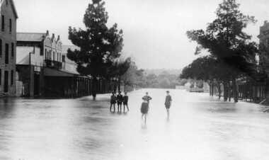
B/W photograph of 1909 flood. Children standing in floodwater in High Street looking West from Corner of Armstrong Street Charlton. -
 Charlton Golden Grains Museum Inc
Photograph, 1972 Flash Flood
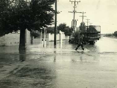
B/W photograph of 1972 flash flood Corner High Street & Armstrong Streets. Man crossing road through flood water. -
 Bendigo Historical Society Inc.
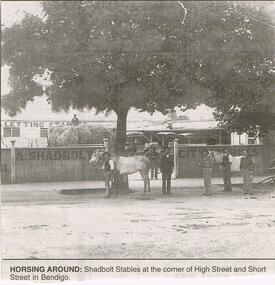
Newspaper - JENNY FOLEY COLLECTION: HORSING AROUND
Bendigo Advertiser "The way we were" from 1999. Horsing around: Shadbolt stables at the corner of High Street and Short Street, Bendigo.newspaper, bendigo advertiser, the way we were